DMVwx
@dmvweatherplus
Weather page mostly focused on events in and around the DMV
ID: 1454187062039650309
29-10-2021 20:43:14
3,3K Tweet
328 Takipçi
566 Takip Edilen
 's Twitter Profile Photo")
 's Twitter Profile Photo")
 on Twitter photo ❄️ Odds rising for one of D.C.’s biggest winter storms in years this weekend
Confidence is growing that we could see one of our biggest winter storms in years between late Saturday and early Monday. Heavy snow and possibly ice are likely, along with bitter, long-lasting cold")
 's Twitter Profile Photo")
 on Twitter photo The National Weather Service (NWS) has issued a Winter Storm Watch and released its first maps that cover snowfall only until 7am Sunday.
Maps that include projected snowfall for the whole storm will be out this evening.
Full article: mocoshow.com/2026/01/22/nws…")
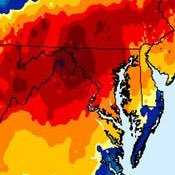
 on Twitter photo High temps here in NW DC topped out around 60 degrees today. Hard to believe we’ll be struggling to break 20 in a couple days… Going to be making a thread later on the upcoming storm and what we can expect in the aftermath. #dcwx #mdwx #vawx")
 's Twitter Profile Photo")
 's Twitter Profile Photo")
 on Twitter photo Tonight marks the beginning of one of the most coldest periods in DC history as a cold front rushes in arctic air.
A reminder that a Cold Weather Advisory is in effect for the ENTIRE region tonight. Wind chill values of -5 to -20 is expected.
Hypothermia frostbite may occur")
 's Twitter Profile Photo")
 on Twitter photo Some VERY impressive snowfall reports today!
BWI: 11.1”
Bentley springs: 11.3”
Cockeysville: 10.0”
Westminster: 9.0”
Bloomfield: 10.2”
Forest Hill: 10.1”
Clarksville: 11.1”
Columbia: 9.7”
Clarksburg: 10.8”
Germantown: 9.0”
Brentwood: 9.0”
Sabillasville: 9.3”
Boonsboro: 9.1”")
 's Twitter Profile Photo")
 on Twitter photo DC roads, 3 days after the storm.
What gives <a href=\"/DCDPW/\">DC Department of Public Works</a>?!?! <a href=\"/311DCgov/\">DC311</a>? Anyone?")
 on Twitter photo NEW: This is shaping up to be one of D.C. longest cold spells in 150 years
D.C. plunged to 13 degrees on Tuesday morning, while many locations in the region dipped into the single digits and below zero.
The frigid morning was part of a punishing cold snap that ramped up")
 on Twitter photo Low of 14 today in Columbia Heights, a fair bit higher than forecast but still quite cold. Many more days of this to come. Roads and sidewalks still in a bad state, if more snow does fall this weekend things will be ugly. #dcwx")
 on Twitter photo When is this \"snowcrete\" nonsense going to finally MELT?
Wouldn't surprise us if some of it is still hanging around in MARCH.
The prolonged cold has largely prevented the frozen conglomeration that fell on Sunday from melting, and there’s no sign of a meaningful thaw or")
 on Twitter photo Takeaways from AFD tonight
- Immediate increase in winds
- Dangerously cold wind chills not seen in 30 years
- Power outages will last for days
- Frostbite in 30 minutes")
 's Twitter Profile Photo")
 on Twitter photo Winds continue to increase this morning with the strongest winds around mid-afternoon. Wind chills continue to fall as well with most locations seeing values well below zero through Sun. AM. Instances of wind damage & power outages remain a concern. #MDwx #VAwx #WVwx #DCwx")
 's Twitter Profile Photo")
@dmvweatherplus
Weather page mostly focused on events in and around the DMV
ID: 1454187062039650309
29-10-2021 20:43:14
3,3K Tweet
328 Takipçi
566 Takip Edilen
 on Twitter photo BY THE NUMBERS! 🥶❄️
DC just had their coldest half-month period (16 days) in THIRTY-TWO years!
Accounting for missing data...since the day before our snow/sleet event (January 24th) though yesterday (February 8th) the average temperature at DCA was 23.1°F.
This passes the")