Donnie (@dharmaintel) 's Twitter Profile
Donnie

@dharmaintel

Even if a snake is not poisonous, it should pretend to be venomous.

ID: 1651225777994604545

calendar_today26-04-2023 14:04:52

145 Tweet

677 Takipçi

18 Takip Edilen

Singh (@duorope) 's Twitter Profile Photo

IndiaToday 's OSINT Team is calling these as "Illegal border Village" near Sela Pass. Quite an incompetent team. Ruining the reputation of a good news channel. indiatoday.in/india/story/us…

<a href="/IndiaToday/">IndiaToday</a> 's OSINT Team is calling these as "Illegal border Village" near Sela Pass. Quite an incompetent team. Ruining the reputation of a good news channel. 
indiatoday.in/india/story/us…
Donnie (@dharmaintel) 's Twitter Profile Photo

The “breached border” lies in POK - this development while concerning, appears to have been Intentionally sprinkled with unsavoury spices - and no, it doesn’t answer any question with permanence

Donnie (@dharmaintel) 's Twitter Profile Photo

Not an exclusive - just an attempt to bring some light to the new road in Shaksgam valley, where it sits and how it’s beyond our control zones, for now. Each development purposely spiced up and sensationalised does us no good.

Not an exclusive - just an attempt to bring some light to the new road in Shaksgam valley, where it sits and how it’s beyond our control zones, for now. 

Each development purposely spiced up and sensationalised does us no good.
Donnie (@dharmaintel) 's Twitter Profile Photo

Again. These are not barracks. These are compact earth built temporary deployment areas with tarps covering. And you can clearly see the training zone near by outlined by tracks in the dirt. Here is more recent image to emphasise the fact ..

Again. These are not barracks. 
These are compact earth built temporary deployment areas with tarps covering. And you can clearly see the training zone near by outlined by tracks in the dirt. 

Here is more recent image to emphasise the fact ..
Abhijit Iyer-Mitra (@iyervval) 's Twitter Profile Photo

Sir please stop spreading #FakeNews. Here’s a news item from 2013 when you ran the government clearly stating the Chinese had denied you access to Sirijap - the area in question. Also they built a full fledged obs/intel base in the area by 2009 - also when you were in power

Sir please stop spreading #FakeNews. Here’s a news item from 2013 when you ran the government clearly stating the Chinese had denied you access to Sirijap - the area in question. Also they built a full fledged obs/intel base in the area by 2009 - also when you were in power
Donnie (@dharmaintel) 's Twitter Profile Photo

A standard operation much like own forces have. These tarmacs for Hptrs are likely to be used for VIP visits or medivac over force concentration as they are less equipped for fast rotation/TAT of hptrs.

Donnie (@dharmaintel) 's Twitter Profile Photo

Adding overhead mapping and some critical facts for clarity of readers, the area mentioned IS NOT along but at least 17kms away from own control areas in a PLA control zone (since 1962), adjacent to EXISTING Chinese settlements - indicating a likely expansion

Adding overhead mapping and some critical facts for clarity of readers, the area mentioned IS NOT along but at least 17kms away from own control areas in a PLA control zone (since 1962), adjacent to EXISTING Chinese settlements - indicating a likely expansion
Donnie (@dharmaintel) 's Twitter Profile Photo

A simple awareness map for those who dont understand the ground situation at Pangong, also for those who take great pleasure in misleading others

A simple awareness map for those who dont understand the ground situation at Pangong, also for those who take great pleasure in misleading others
Donnie (@dharmaintel) 's Twitter Profile Photo

Some facts intentionally ignored on the recent developments surrounding the LAC - The bridge in Pangong, sits in territory held by China since 1962 - The village in Demchok, DOES NOT SIT ALONG the LAC but at least 17-km away, again in territory held by China since 1962

Some facts intentionally ignored on the recent developments surrounding the LAC 

- The bridge in Pangong, sits in territory held by China since 1962 
- The village in Demchok, DOES NOT SIT ALONG the LAC but at least 17-km away, again in territory held by China since 1962
Kyang Thang རྐྱང་ཐང་ (@kyangs_thang) 's Twitter Profile Photo

This is what 60 kms. looks like from the watershed (red line), which is not yet officially our territory on maps (yellow line). By this logic, PLA should be sitting at Hayuliang! PLA is known to come till before the yellow line. IA also patrols up to Hadigara (watershed).

This is what 60 kms. looks like from the watershed (red line), which is not yet officially our territory on maps (yellow line).

By this logic, PLA should be sitting at Hayuliang!

PLA is known to come till before the yellow line. IA also patrols up to Hadigara (watershed).
Alpha Defense™ (@alpha_defense) 's Twitter Profile Photo

#MISINFORMATION : This is the Chinese Side of #PangongTSO. About two-thirds of the lake is under China's control, and about 45 km is under Indian control. The LAC, which runs from north to south, "cuts the western part of the lake, aligned east-west." thelogicalindian.com/fact-check/chi…
Singh (@duorope) 's Twitter Profile Photo

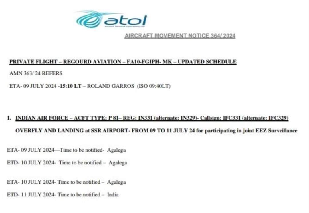
In July, a P-8I of the Indian Navy (IN331) made a stop at Agalega Island as part of a maritime surveillance exercise. lexpress.mu/s/toujours-pas…

In July, a P-8I of the Indian Navy (IN331) made a stop at Agalega Island as part of a maritime surveillance exercise. 
lexpress.mu/s/toujours-pas…
Donnie (@dharmaintel) 's Twitter Profile Photo

1 That "mysterious structure" is a camo covered bunker 2 It was built in AUGUST 2022, your image source about sept 2024 might be incorrect , image attached to show the real date of your image

1 That "mysterious structure" is a camo covered bunker  

2 It was built in AUGUST 2022, your image source about sept 2024 might be incorrect , image attached to show the real date of your image
Donnie (@dharmaintel) 's Twitter Profile Photo

Built in 2022 reported widely in the press long ago - theprint.in/defence/china-… Location is BEYOND FINGER 8 - BEYOND Sirijap !! maps.app.goo.gl/xcQMCLWraTg16C…

Donnie (@dharmaintel) 's Twitter Profile Photo

Regarding the recent controversy on data security within the armed forces, here's an example of how data exposure threatens own assets/infra Image - Strava physical exercise tracking app map of an IAF airbase showing movement tracks complied within the base

Regarding the recent controversy on data security within the armed forces, here's an example of how data exposure threatens own assets/infra 

Image - Strava physical exercise tracking app map of an IAF airbase showing movement tracks complied within the base
Donnie (@dharmaintel) 's Twitter Profile Photo

Aircraft took off at approximately 0600 UTC from Agra, landed at Chandigarh at 0900 UTC ,took off again at 1345 UTC , descending again at 1615UTC - Supporting standard air training missions in the region nothing alarming or new, not 9+ hours but 3 + 2.30 hours

Donnie (@dharmaintel) 's Twitter Profile Photo

Site A - since no one can figure it out - is a buried artillery firing point, there are 5-6 such sites across the LC now Site B - Helipad. Site C - has ALWAYS sustained "human presence" and holds no civil use, its a military lake patrol/forward post and its expanding !

Donnie (@dharmaintel) 's Twitter Profile Photo

Here is an image from 2018, showing the same road on imagery, there seems to be an interpretation error looking at snow/non snow images leading to the assumption that the road in this section is new !

Here is an image from 2018, showing the same road on imagery, there seems to be an interpretation error looking at snow/non snow images leading to the assumption that the road in this section is new !