James O'Connor (@james_o_connor1) 's Twitter Profile
James O'Connor

@james_o_connor1

I'm interested in satellites, cameras, computers and lasers. @satellitevu

ID: 102433075

linkhttp://jamesoconnorkingston.wordpress.com calendar_today06-01-2010 17:47:24

793 Tweet

418 Followers

669 Following

David Bitner (@bitnerd) 's Twitter Profile Photo

Happy #GISDay, the holiday where the even bigger party is the next day. Hope to see lots of y'all tomorrow for #PostGIS day info.crunchydata.com/postgis-day-20…. There's still time to hear me talk about #PgSTAC, @vincentsarago talk about #TiFeatures/#TiMVT and lots of other great talks!

Mathias Disney (@mathiasdisney) 's Twitter Profile Photo

This is a really thoughtful thread that really nails the key issue - what is a university education for? That fundamental Q seems to have a v different A now than it used to

James O'Connor (@james_o_connor1) 's Twitter Profile Photo

I finally listened to this, and it was absolutely superb! I love meeting people like Grega, just so focused on the value and building, but also so down to Earth - cuts through in this format. Thanks Max Lenormand for this, will have to start on the back catalogue I've missed

SparkgeoUK (@sparkgeouk) 's Twitter Profile Photo

Hey folks! Join us at the Spatio-Temporal Asset Catalogue (STAC) UK meet up on 13th June in London. Explore opportunities to collaborate with UK STAC practioners and tap into the wisdom of PSC STAC member - Sparkgeo's James Banting! eventbrite.co.uk/e/spatio-tempo… @Eventbrite

James O'Connor (@james_o_connor1) 's Twitter Profile Photo

UK based EO/geo folks - we're hosting a STAC meetup at SatVu's offices - come along! Great views, great company, great metadata discussions #STAC eventbrite.co.uk/e/spatio-tempo…

Lukas C. H. (@gewoonlukas_) 's Twitter Profile Photo

Now that SpaceX has published the full manifest, here's the final version with the final satellites now also identified: x.com/SpaceX/status/…

Now that SpaceX has published the full manifest, here's the final version with the final satellites now also identified: x.com/SpaceX/status/…
🛰🌍🌊Dr Hayley Evers-King 🇪🇺🇬🇧🇿🇦🇩🇪 (@hayleyeversking) 's Twitter Profile Photo

I see a lot of satellite data, so it takes something quite special for me to go wow...but WOW! Incredible first animations of data from the Lightning Imager aboard EUMETSAT newest satellite #MTGI1! Find out more eumetsat.int/features/anima…

OSGeo IE (@osgeoie) 's Twitter Profile Photo

#FOSS4GUK2023 - Maynooth University - Thursday 7th September Our OSGeoIE event as part of FOSS4G UK Local 2023 happens next week - here is the venue room with lots of comfy seats! Reserve one of those seats now - registration still open uk.osgeo.org/foss4guklocal2…

#FOSS4GUK2023 - Maynooth University - Thursday 7th September 

Our OSGeoIE event as part of FOSS4G UK Local 2023 happens next week - here is the venue room with lots of comfy seats! 

Reserve one of those seats now - registration still open 
uk.osgeo.org/foss4guklocal2…
Sentinel Hub (@sentinel_hub) 's Twitter Profile Photo

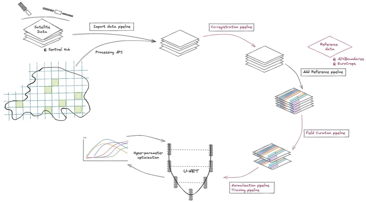
☝️ We just released a new version of our automatic #FieldDelineation on #Sentinel-2 imagery! 🎉 We've improved the AI model, workflow and results and report all the details in our latest blog post ➡️ medium.com/sentinel-hub/a…

☝️ We just released a new version of our automatic #FieldDelineation on #Sentinel-2 imagery! 🎉 We've improved the AI model, workflow and results and report all the details in our latest blog post ➡️  medium.com/sentinel-hub/a…
Isobel Gray (@ij_gray) 's Twitter Profile Photo

#30DayMapChallenge day 1 (a bit late...) Theme: Points In black: areas just licensed for new oil & gas in *phase 1* of the government's 33rd licensing round In yellow: offshore wind bids in government's most recent auction When will they get the point? #decarbonise

#30DayMapChallenge day 1 (a bit late...)
Theme: Points

In black: areas just licensed for new oil & gas in *phase 1* of the government's 33rd licensing round

In yellow: offshore wind bids in government's most recent auction

When will they get the point?
#decarbonise
Wendy Shijia (@shijiawendy) 's Twitter Profile Photo

🎉 #30DayMapChallenge Day2: Lines Line style Mt Everest again, but this time it's interactive! 🔗 my.spline.design/everestlineart…

Isobel Gray (@ij_gray) 's Twitter Profile Photo

Playing catch-up with the #30DayMapChallenge. Day 5's theme was "Analog Map"*, which I took literally, sticking to the country I know best. Drawn freehand from memory, with a colour scheme inspired by our other national drink🥃 *Not to be confused with Day 7 (Navigation)

Playing catch-up with the #30DayMapChallenge. Day 5's theme was "Analog Map"*, which I took literally, sticking to the country I know best. 

Drawn freehand from memory, with a colour scheme inspired by our other national drink🥃

*Not to be confused with Day 7 (Navigation)
ESA Earth Observation (@esa_eo) 's Twitter Profile Photo

🆕🚨We are offering access to satellite-based thermal infrared imaging from HotSat-1. HotSat-1 is the first of a planned constellation of nine satellites, and was the first commercial satellite to offer high-resolution thermal infrared imagery for Earth observation. The

🆕🚨We are offering access to satellite-based thermal infrared imaging from HotSat-1.

HotSat-1 is the first of a planned constellation of nine satellites, and was the first commercial satellite to offer high-resolution thermal infrared imagery for Earth observation. The