GEOlayers (@geolayers) 's Twitter Profile
GEOlayers

@geolayers

Maps for After Effects / Animated maps in Browser GEOLayers.app

ID: 2853392963

linkhttp://aescripts.com/geolayers calendar_today31-10-2014 15:42:30

3,3K Tweet

1,1K Followers

474 Following

MapTiler (@maptiler) 's Twitter Profile Photo

We’ve spun a 🕸️ web map 🕸️ of haunted placenames here: maptiler.link/3LA3B8j #Halloween #Cartography #SpookyMaps #WebMaps

GEOlayers (@geolayers) 's Twitter Profile Photo

#30DayMapChallenge - #Points - Birthplaces of German Chancellors #30DayMapChallenge #Points #Mapping #Cartography #MapArt #GeoData #GIS #SpatialData #DataViz #MapDesign #MapMaker #GeoVisualization #MapChallenge #GeoLayers.app #GeoLayersApp #GeoLayers #GEOlayersCommunity

GEOlayers (@geolayers) 's Twitter Profile Photo

#30DayMapChallenge - #Lines - With GEOlayers.app, animate line features directly in your browser – no After Effects needed. #Mapping #Cartography #MapArt #GeoData #GIS #SpatialData #DataViz #MapDesign #MapMaker #GeoVisualization #GeoLayers MapTiler BOONE

Sam J (@samwise_v) 's Twitter Profile Photo

#30DayMapChallenge Day 2 - Lines And time for my obligatory #joyplot map. This time based on building heights in the Isle of Dogs / Canary Wharf area.

Tom Patterson (@mtnmapper) 's Twitter Profile Photo

Hello/Hola/Olá - My South America Physical Map is now available. You can get it here (for free): shadedrelief.com/south-america/

Hello/Hola/Olá - My South America Physical Map is now available. You can get it here (for free): shadedrelief.com/south-america/
Kenneth Wong (@kenneth_khw) 's Twitter Profile Photo

#30DayMapChallenge Day 3 - Polygons Land use distribution of Mong Kok, Hong Kong Classified into 6 major categories: built structure, open space, carriageway, footway, alleyway, others

#30DayMapChallenge Day 3 - Polygons

Land use distribution of Mong Kok, Hong Kong

Classified into 6 major categories: built structure, open space, carriageway, footway, alleyway, others
GEOlayers (@geolayers) 's Twitter Profile Photo

#30DayMapChallenge - Day 3 - Polygons – focuses on areas: regions, land use, boundaries! Made with GEOlayers.app #Mapping #Cartography #MapArt #GeoData #GIS #SpatialData #DataViz #MapDesign #MapMaker #GeoVisualization #GeoLayers MapTiler BOONE

GEOlayers (@geolayers) 's Twitter Profile Photo

#30DayMapChallenge - Day 4 - My Data – Guess Who Traveled More? Made with GEOlayers.app #Mapping #Cartography #MapArt #GeoData #GIS #SpatialData #DataViz #MapDesign #MapMaker #GeoVisualization #GeoLayers MapTiler BOONE

Tomás Maroni (@maroni_editor) 's Twitter Profile Photo

💙🥰سيدي الحاج أبو بكر الأمين ELAsBa Yes! I downloaded my route as KML from Google My Maps. Then I converted it to GeoJSON (with QGIS), and imported it into After Effects, where I used the #Geolayers plugin to animate the route and create the globe (as well as stylizing it a bit).

MapTiler (@maptiler) 's Twitter Profile Photo

We're supporting Jimmy Pelletier's incredible 40,000 km World Tour! 🌍🚴 He's cycling across 5 continents & 27 countries to raise funds for people with disabilities. Track his journey (Stage 3 in progress!) on the interactive map: maptiler.link/3JDt93Y

GEOlayers (@geolayers) 's Twitter Profile Photo

#30DayMapChallenge - Day 5 - Earth - Made with GEOlayers.app #Mapping #Cartography #MapArt #GeoData #GIS #SpatialData #DataViz #MapDesign #MapMaker #GeoVisualization #GeoLayers MapTiler BOONE

Hemed (@725hemeed) 's Twitter Profile Photo

#30DayMapChallenge Day 6 - Dimension A 3-D Georeferenced Map of Antarctica 🇦🇶 "Antarctica Polar Steriographic" produced by " Common Wealth Australia ",1986 edition 4 #gischat #Antarctica #SouthPole #map #qgis #b3d

#30DayMapChallenge Day 6 - Dimension  A 3-D Georeferenced Map of Antarctica 🇦🇶 "Antarctica Polar Steriographic"  produced by " Common Wealth Australia ",1986 edition 4  #gischat #Antarctica #SouthPole #map #qgis #b3d
Tatiana Pashagina (@viola__alba) 's Twitter Profile Photo

#30DayMapChallenge Day 7 – Accessibility. Toilets🤷‍♀️ Sometimes, it's the most important kind of accessibility🤭 #map #gis #qgis

#30DayMapChallenge Day 7 – Accessibility. Toilets🤷‍♀️ Sometimes, it's the most important kind of accessibility🤭

#map #gis #qgis
Sam J (@samwise_v) 's Twitter Profile Photo

#30DayMapChallenge: Day 7: Accessibility Walking times from Birmingham New Street. Made in #qgis with Ordnance Survey #zoomstack data and using the HERE Technologies maps routing API.
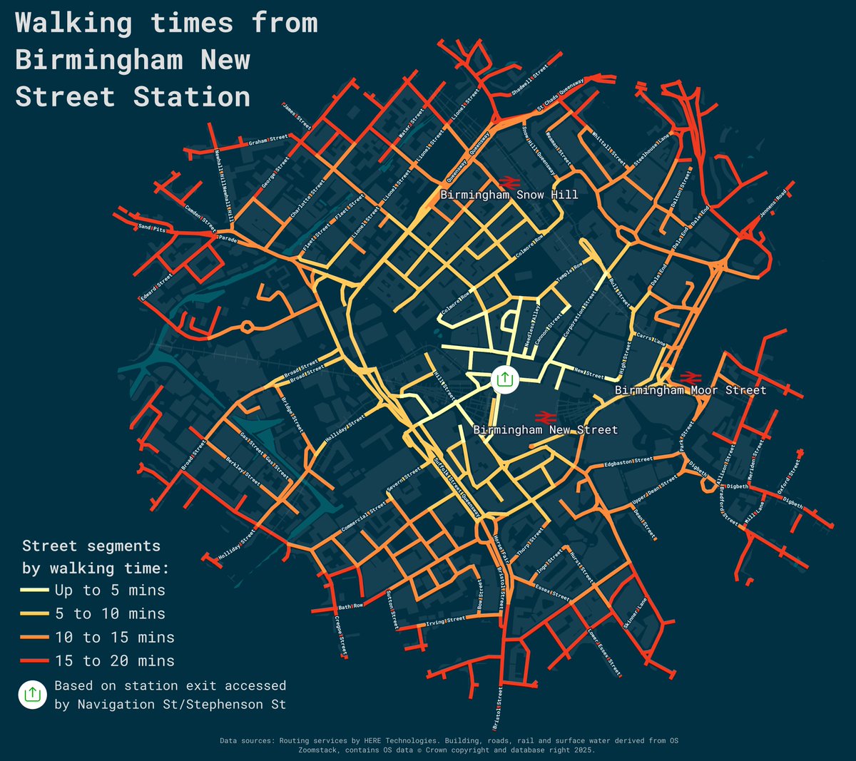
#30DayMapChallenge: Day 7: Accessibility

Walking times from Birmingham New Street. Made in #qgis with <a href="/OrdnanceSurvey/">Ordnance Survey</a> #zoomstack data and using the <a href="/here/">HERE Technologies</a> maps routing API.
MapTiler (@maptiler) 's Twitter Profile Photo

Our latest monthly geocoding update focused mainly on adding streets with address points (now up to 30 million) and points of interest (increased to 58 million). Our database now has nearly 106 million features in total! Explore the spatial search: maptiler.link/3WJumK5

Tomás Maroni (@maroni_editor) 's Twitter Profile Photo

Day 10 — Air Flight routes departing from Atlanta (ATL) and Shanghai (PVG). The busiest air hubs of the United States and China. Mapping the patterns of global air travel. #30DayMapChallenge

Day 10 — Air

Flight routes departing from Atlanta (ATL) and Shanghai (PVG).
The busiest air hubs of the United States and China.

Mapping the patterns of global air travel.

#30DayMapChallenge