Dave Lieb (@davidjlieb) 's Twitter Profile
Dave Lieb

@davidjlieb

Multi-instrumentalist, session musician, performer, composer/songwriter, music teacher, Storm Chaser/Skywarn Spotter, Weather & Aviation enthusiast/geek

ID: 26268519

linkhttp://www.facebook.com/davidjlieb calendar_today24-03-2009 16:29:23

2,2K Tweet

207 Takipçi

529 Takip Edilen

Corin Major 7 (@thecorinashley) 's Twitter Profile Photo

I had tremendous birthday fun yesterday. I played at a surprise party for my pal Jon Lupfer at Q Division Studios with many friends I haven’t seen in ages. The surprise being that Jon’s birthday was in September. It was a gas.

I had tremendous birthday fun yesterday. I played at a surprise party for my pal Jon Lupfer at <a href="/qdivisionstudio/">Q Division Studios</a> with many friends I haven’t seen in ages. The surprise being that Jon’s birthday was in September. It was a gas.
Weather Track US (@weathertrackus) 's Twitter Profile Photo

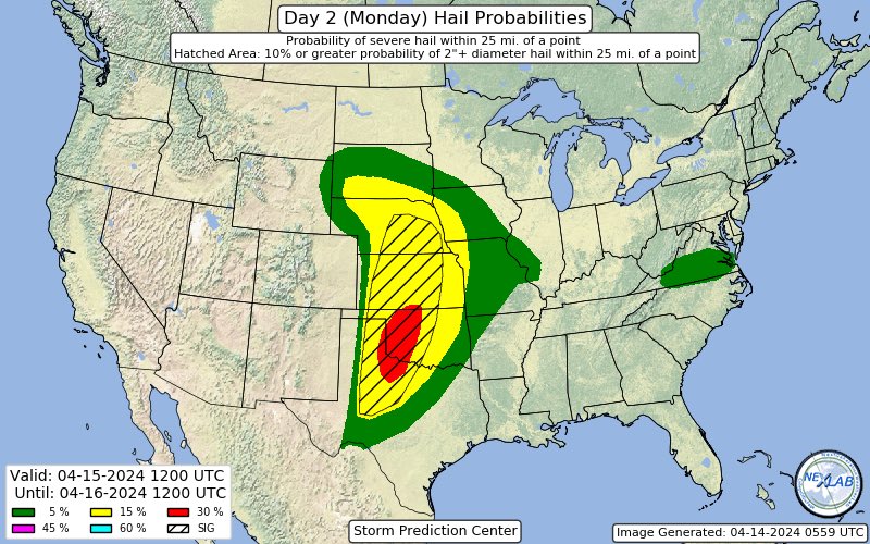
Enhanced Risk of severe storms for Monday across parts of Texas & Oklahoma. All severe hazards are possible. #kswx #okwx #txwx #weather

Enhanced Risk of severe storms for Monday across parts of Texas &amp; Oklahoma.

All severe hazards are possible.

#kswx #okwx #txwx #weather
NWS Storm Prediction Center (@nwsspc) 's Twitter Profile Photo

1:06am CDT #SPC Day1 Outlook Moderate Risk: across parts of North Texas Oklahoma Southeast Kansas and Far Southwest Missouri spc.noaa.gov/products/outlo…

1:06am CDT #SPC Day1 Outlook Moderate Risk: across parts of North Texas Oklahoma Southeast Kansas and Far Southwest Missouri spc.noaa.gov/products/outlo…
NWS Norman (@nwsnorman) 's Twitter Profile Photo

Significant severe weather outbreak is likely late tomorrow afternoon and into the evening across the plains, including our forecast area. Be prepared for potential strong, long-tracked tornadoes, giant hail (3-4 inches), and damaging winds. #okwx #texomawx

Significant severe weather outbreak is likely late tomorrow afternoon and into the evening across the plains, including our forecast area.

Be prepared for potential strong, long-tracked tornadoes, giant hail (3-4 inches), and damaging winds.

#okwx #texomawx
NWS Boston (@nwsboston) 's Twitter Profile Photo

[EF-1 Tornado Confirmed from June 26th] Survey is now completed. The Lincoln to Cumberland RI to North Attleborough MA tornado from late evening on June 26th is rated an EF-1, with maximum winds of 100 mph. Path length 4.3 miles with a maximum width of 100 yards. More details:

[EF-1 Tornado Confirmed from June 26th] Survey is now completed. The Lincoln to Cumberland RI to North Attleborough MA tornado from late evening on June 26th is rated an EF-1, with maximum winds of 100 mph. Path length 4.3 miles with a maximum width of 100 yards. More details:
Hilbert College Men’s Soccer (@hilbert_msoccer) 's Twitter Profile Photo

Congratulations to Carter Burke, Jason Vullo & Cam Murdie on their 3rd team @amcc_sports all conference selection. All 3 helped us to a 4th place finish in conference, our highest ever, these outstanding student athletes get the recognition their stellar play all season deserved

Congratulations to Carter Burke, Jason Vullo &amp; <a href="/MurdieCam/">Cam Murdie</a> on their 3rd team @amcc_sports all conference selection. All 3 helped us to a 4th place finish in conference, our highest ever, these outstanding student athletes get the recognition their stellar play all season deserved
NWS Storm Prediction Center (@nwsspc) 's Twitter Profile Photo

1:01am CDT #SPC Day1 Outlook Moderate Risk: across much of central and eastern Oklahoma into the western Ozarks spc.noaa.gov/products/outlo…

1:01am CDT #SPC Day1 Outlook Moderate Risk: across much of central and eastern Oklahoma into the western Ozarks spc.noaa.gov/products/outlo…
Tucker Antico (@tuckerweather) 's Twitter Profile Photo

Incredible vantage of a WALL CLOUD spotted from Gardner, MA! A tornado did not touch down here, but this storm got awfully close! ▶️ Shot by Eric Hulette (3:14PM)