CARICOOS (@caricoos) 's Twitter Profile
CARICOOS

@caricoos

ID: 20993979

linkhttp://www.caricoos.org calendar_today16-02-2009 15:30:54

424,424K Tweet

1,1K Followers

2 Following

CARICOOS (@caricoos) 's Twitter Profile Photo

Join the IOOS Association and the 11 IOOS Regional Associations today, June 25, as we celebrate the launch of Ocean Data Day! PR Sea Grant #OceanDataDay #DataBelowtheSurface #IOOS #WorldOceanDay #OceanMonth.

Join the IOOS Association and the 11 IOOS Regional Associations today, June 25, as we celebrate the launch of Ocean Data Day! <a href="/SeaGrantPR/">PR Sea Grant</a> #OceanDataDay #DataBelowtheSurface #IOOS #WorldOceanDay #OceanMonth.
Mid-Atlantic Ocean Data Portal (@portalmarco) 's Twitter Profile Photo

Did somebody say #OceanDataDay? The Mid-Atlantic Ocean Data Portal offers 6,000+ maps showing marine life, offshore infrastructure, habitats, fishing, recreation and much more off our coast. Browse it today at portal.midatlanticocean.org

IOOS Association (@ioosassociation) 's Twitter Profile Photo

This #OceanDataDay, explore the full suite of IOOS Data Portals – 11 regional gateways delivering real-time insights that power science, safety, and maritime economy. Visit to find your Region: ioosassociation.org/data-portals/ #OceanData #DataBelowTheSurface #OceanScience #BlueEconomy

This #OceanDataDay, explore the full suite of IOOS Data Portals – 11 regional gateways delivering real-time insights that power science, safety, and maritime economy. Visit to find your Region: ioosassociation.org/data-portals/

#OceanData #DataBelowTheSurface #OceanScience #BlueEconomy
CARICOOS (@caricoos) 's Twitter Profile Photo

As in other US IOOS regions exposed to hurricanes and typhoons, CARICOOS, in collaboration with NOAA/AOML, has commenced the deployment of hurricane gliders in PR and USVI waters. Ocean salinity and temperature data collected by them provide for more accurate hurricane forecasts.

IOOS Association (@ioosassociation) 's Twitter Profile Photo

Real-time data saves lives. The U.S. Coast Guard and local search and rescue integrate surface current data to make location predictions up to 5× more accurate. Happy #OceanDataDay and THANK YOU to #firstresponders! #CGSAR #OceanData #SearchAndRescue #USCoastGuard #DataBelowTheSurface

IOOS Association (@ioosassociation) 's Twitter Profile Photo

How many IOOS-powered assets are monitoring our #coastalwaters? Assets like radar, buoys, gliders, sensors, and more are collecting real-time data to keep communities safe, economies strong, etc. Explore them all: ioosassociation.org/data-portals/ #OceanData #OceanObserving

How many IOOS-powered assets are monitoring our #coastalwaters? Assets like radar, buoys, gliders, sensors, and more are collecting real-time data to keep communities safe, economies strong, etc. Explore them all: ioosassociation.org/data-portals/

#OceanData #OceanObserving
CARICOOS (@caricoos) 's Twitter Profile Photo

Ocean Data- Enhanced Marine Safety: For fishermen, sailors, and ocean sports enthusiasts, real-time ocean data (e.g., wave heights, wind speed, water temperature) provides essential information for planning safe activities on the water.

CARICOOS (@caricoos) 's Twitter Profile Photo

Mobile ocean data to enhance safety and decision-making while on the water. #WorldOceanMonth #OceanDataDay #DataBelowtheSurface #IOOS IOOS Association

Scripps Institution of Oceanography (@scripps_ocean) 's Twitter Profile Photo

This #OceanDataDay, discover how ocean data reveals the health of our seas, while driving action to protect & restore this ecosystem. 🌊 Ocean acidification: bit.ly/3JSHC89 🌊 Ocean deoxygenation: bit.ly/3G9qSfe 🌊 Marine heat waves: bit.ly/40m4rKo

This #OceanDataDay, discover how ocean data reveals the health of our seas, while driving action to protect &amp; restore this ecosystem.

🌊 Ocean acidification: bit.ly/3JSHC89
🌊 Ocean deoxygenation: bit.ly/3G9qSfe
🌊 Marine heat waves: bit.ly/40m4rKo
CARICOOS (@caricoos) 's Twitter Profile Photo

CARICOOS GLIDERS MISSION: HURRICANE SEASON 2025! As the 2025 hurricane season unfolds, CARICOOS is actively deploying underwater gliders to collect real-time ocean data that strengthens hurricane forecasts and supports the safety of Caribbean communities. Stay tuned!

IOOS Association (@ioosassociation) 's Twitter Profile Photo

How do NOAA programs like the Integrated Ocean Observing System (#IOOS) keep people safe - even hundreds of miles from the shore? Download + Share IOOS Association’s newest fact sheet re: inland flooding: ioosassociation.org/wp-content/upl… #ExtremeWeather #OceanData #WeatherPreparedness
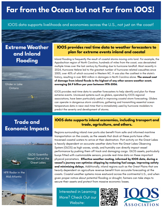
How do <a href="/NOAA/">NOAA</a> programs like the Integrated Ocean Observing System (#IOOS) keep people safe - even hundreds of miles from the shore? Download + Share <a href="/IOOSAssociation/">IOOS Association</a>’s newest fact sheet re: inland flooding: ioosassociation.org/wp-content/upl…

#ExtremeWeather #OceanData #WeatherPreparedness
SECOORA (@secoora) 's Twitter Profile Photo

Last week, USF College of Marine Science Ocean Circulation Lab went out on the R/V Weatherbird to swap the West Florida Shelf real time buoys and non real-time seafloor sensors. Both are vital for hurricane monitoring in the Gulf. #SensorSpotlight #OceanData #IOOS Image Credit: Sam D'Angelo, USF

Last week, <a href="/USFCMS/">USF College of Marine Science</a> Ocean Circulation Lab went out on the R/V Weatherbird to swap the West Florida Shelf real time buoys and non real-time seafloor sensors. Both are vital for hurricane monitoring in the Gulf. 

#SensorSpotlight #OceanData #IOOS

Image Credit: Sam D'Angelo, USF