BJDeming (@bjdeming) 's Twitter Profile
BJDeming

@bjdeming

Here's my bio page: bjdeming.net.

ID: 2460505308

linkhttps://flighttowonder.com calendar_today24-04-2014 00:13:56

6,6K Tweet

91 Followers

367 Following

USGS Volcanoes🌋 (@usgsvolcanoes) 's Twitter Profile Photo

#ESA #Sentinel-1A #interferogram of #Kīlauea showing ground deformation during Sep. 2-14. Signals include dike intrusion between Pauahi and Makaopuhi Craters and rupture of a caldera-bounding fault associated with the M4.3 EQ on September 14. More at ow.ly/OLGr50TnNrK

#ESA #Sentinel-1A #interferogram of #Kīlauea showing ground deformation during Sep. 2-14. Signals include dike intrusion between Pauahi and Makaopuhi Craters and rupture of a caldera-bounding fault associated with the M4.3 EQ on September 14.

More at ow.ly/OLGr50TnNrK
John Cassidy (@earthquakeguy) 's Twitter Profile Photo

Did you feel shaking at 3:22 p.m. PT in the #HaidaGwaii #NorthCoast, northern #VancouverIsland regions? That was a M6.4 #earthquake located south of Haida Gwaii and ~180 km west of Bella Bella. Details/report shaking: earthquakescanada.nrcan.gc.ca/recent/2024/20… Many aftershocks have been recorded.

Did you feel shaking at 3:22 p.m. PT in the #HaidaGwaii #NorthCoast, northern #VancouverIsland regions? 
That was a M6.4 #earthquake located south of Haida Gwaii and ~180 km west of Bella Bella. 
Details/report shaking: earthquakescanada.nrcan.gc.ca/recent/2024/20…
Many aftershocks have been recorded.
John Cassidy (@earthquakeguy) 's Twitter Profile Photo

Aftershocks continue just to the south of #HaidaGwaii, with another 4.2 just a few minutes ago. See live shaking from a nearby seismic station: earthquakescanada.nrcan.gc.ca/stndon/wf-fo/i… If you feel shaking, please repot it here: earthquakescanada.nrcan.gc.ca/dyfi-lavr/inde… Details on the M6.4: earthquakescanada.nrcan.gc.ca/recent/2024/20…

Aftershocks continue just to the south of #HaidaGwaii, with  another 4.2 just a few minutes ago.
See live shaking from a nearby seismic station:
earthquakescanada.nrcan.gc.ca/stndon/wf-fo/i…
If you feel shaking, please repot it here:
earthquakescanada.nrcan.gc.ca/dyfi-lavr/inde…
Details on the M6.4:
earthquakescanada.nrcan.gc.ca/recent/2024/20…
Mineral Cup #MinCup (@mineralcup) 's Twitter Profile Photo

#MinCup24 R1 M16: #Topaz vs. #Spodumene Topaz is a hard, flashy gemstone that is often honey yellow, imperial pink, or rarely deep blue. Pyroxene-group mineral Spodumene is a fascinating blend of workhorse and beauty. VOTE: mineralcup.org/2024/vote/r1m16

hacchan9642 (@hacchan9642) 's Twitter Profile Photo

このところまた活発になったハワイ島キラウエア付近の地震活動、最近(世界時15日から先ほどまで)の震央分布。深さは2km前後が多い。USGS、ハワイ火山観測所の震源データによる。

このところまた活発になったハワイ島キラウエア付近の地震活動、最近(世界時15日から先ほどまで)の震央分布。深さは2km前後が多い。USGS、ハワイ火山観測所の震源データによる。
Stephen Hicks 🇪🇺 (@seismo_steve) 's Twitter Profile Photo

At exactly this time one year ago, a type of seismic signal never seen before started spreading around the world. It lasted for 9 days and it came from Greenland. Just last week, we published our study on what caused it #VLPanniversary science.org/doi/10.1126/sc…

Hawaii Volcanoes NPS (@volcanoes_nps) 's Twitter Profile Photo

Chain of Craters Road is closed to all use due to heightened volcanic activity and gas emissions along the Middle East Rift Zone of Kīlauea. Volcanic Activity Summary from USGS Volcanoes🌋 usgs.gov/volcanoes/kila…

Chain of Craters Road is closed to all use due to heightened volcanic activity and gas emissions along the Middle East Rift Zone of Kīlauea. 

Volcanic Activity Summary from <a href="/USGSVolcanoes/">USGS Volcanoes🌋</a> usgs.gov/volcanoes/kila…
John Cassidy (@earthquakeguy) 's Twitter Profile Photo

Aftershocks of yesterday's M6.5 earthquake offshore #BritishColumbia continue today. 100+ small aftershocks have been detected, and the largest of those (red and orange dots) located. The largest recorded aftershock (at this time) is M4.8. Complete list: earthquakescanada.nrcan.gc.ca/recent/maps-ca…

Aftershocks of yesterday's M6.5 earthquake offshore #BritishColumbia continue today. 100+ small aftershocks have been detected, and the largest of those (red and orange dots) located. The largest recorded aftershock (at this time) is M4.8.
Complete list:
earthquakescanada.nrcan.gc.ca/recent/maps-ca…
BPPTKG (@bpptkg) 's Twitter Profile Photo

Hallo Warga Merapi! Berikut rekapitulasi kejadian APG tanggal 16 September 2024 pukul 18:00 - 24:00 WIB: - Pukul 19.16 WIB, Amplitudo 36 mm, Durasi 106 detik, Jarak luncur 1000 meter, arah ke Barat Daya (Kali Bebeng), Arah angin ke Barat.

Hallo Warga Merapi!
Berikut rekapitulasi kejadian APG tanggal 16 September 2024 pukul 18:00 - 24:00 WIB:

- Pukul 19.16 WIB,
Amplitudo 36 mm, Durasi 106 detik, Jarak luncur 1000 meter, arah ke Barat Daya (Kali Bebeng), Arah angin ke Barat.
USGS Volcanoes🌋 (@usgsvolcanoes) 's Twitter Profile Photo

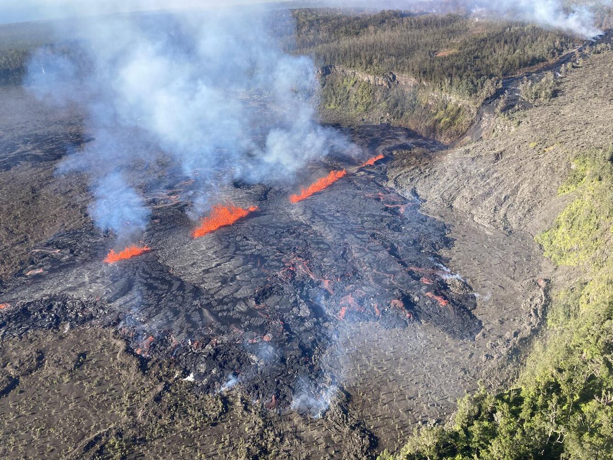
#Kilauea erupted briefly last night in a remote area west of Nāpau Crater on the middle East Rift Zone in Hawaiʻi Volcanoes National Park. Lava eruption started between 9:00-10:00 pm HST (Sep 15, 2024) & has ended. Sulfur dioxide continues to de-gas from vents. Vegetation burned.

James Spann (@spann) 's Twitter Profile Photo

From Steve Glenn “Hi James. Steve the pilot here. Brilliant northern lights over the North Atlantic, flying from London to Memphis”

From Steve Glenn “Hi James. Steve the pilot here. Brilliant northern lights over the North Atlantic, flying from London to Memphis”
USGS Volcanoes🌋 (@usgsvolcanoes) 's Twitter Profile Photo

#Kilauea volcano's middle East Rift Zone eruption resumed late on Sep 16, 2024, and continues this morning within a remote area of Hawaiʻi Volcanoes National Park. During the AM overflight, #HVO geologists observed fountaining & active lava flows on the floor of Nāpau Crater.

#Kilauea volcano's middle East Rift Zone eruption resumed late on Sep 16, 2024, and continues this morning within a remote area of Hawaiʻi Volcanoes National Park. During the AM overflight, #HVO geologists observed fountaining &amp; active lava flows on the floor of Nāpau Crater.
USGS Volcanoes🌋 (@usgsvolcanoes) 's Twitter Profile Photo

#USGS #HVO geologists collect fresh lava at #Kilaueaʻs eruption site in Nāpau Crater this morning. Molten lava goes into bucket, rapidly quenched by water. Fast quench preserves geochemistry, provides clues about conditions in the magmatic system & magma’s pathway to the surface.

BJDeming (@bjdeming) 's Twitter Profile Photo

X translation: "The air was clear today and we could see Mt. Fuji 🗻 In the foreground is the Izu Peninsula." 😍 #volcano