adam j martin (@techfrogg) 's Twitter Profile
adam j martin

@techfrogg

interested in spatial econ, affordable housing, zoning abolition, and combining spatial and graph analytics...

ID: 267222677

calendar_today16-03-2011 14:51:49

1,1K Tweet

422 Takipçi

929 Takip Edilen

adam j martin (@techfrogg) 's Twitter Profile Photo

The plenary sessions for the Esri #DevSummit are free to all. Register to get a reminder to watch the livestream coverage. ow.ly/8wQ050Eh9Jd

The plenary sessions for the Esri #DevSummit are free to all. Register to get a reminder to watch the livestream coverage. ow.ly/8wQ050Eh9Jd
Esri (@esri) 's Twitter Profile Photo

And they're off! Follow along as we track the Red Bull X-Alps athletes in this immersive 3D VR app as they compete to win the world’s toughest adventure race. Experience it here: ow.ly/qPmM50FdSoU #redbullxalps #ArcGISPlatform

Esri (@esri) 's Twitter Profile Photo

With the #ArcGIS Maps SDKs for Unity3D (inactive) and Unreal Engine, you can use game engines to create cost-effective, immersive simulations and realistic urban scenarios. #GDC21 🔹Join the beta program: ow.ly/fLt650Fzj4B 🔹See it in action: ow.ly/5cfW50Fzj4C

adam j martin (@techfrogg) 's Twitter Profile Photo

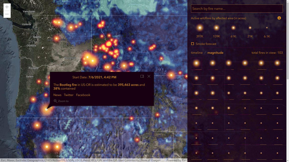
The USA Wildfires app tracks active fires and smoke forecasts in the U.S. Did you know, in the "magnitude" view, each fire's estimated containment is shown as a proportional line beneath its symbol? ow.ly/3M0R102QFKk

The USA Wildfires app tracks active fires and smoke forecasts in the U.S. Did you know, in the "magnitude" view, each fire's estimated containment is shown as a proportional line beneath its symbol? ow.ly/3M0R102QFKk
adam j martin (@techfrogg) 's Twitter Profile Photo

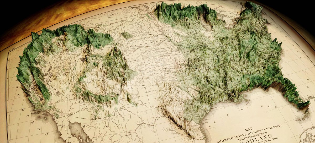
How to make this map of forest density (that mashes up a map from 1883 with modern data) appearing in GIS for Science, Vol 3. ow.ly/7uIR102QFKw #ArcGISPro

How to make this map of forest density (that mashes up a map from 1883 with modern data) appearing in GIS for Science, Vol 3. ow.ly/7uIR102QFKw #ArcGISPro
adam j martin (@techfrogg) 's Twitter Profile Photo

The USGS, Geospatial Information Response Team has been selected to receive a Special Achievement in GIS Award at the 2021 Esri User Conference. The team facilitates coordination and communication of geospatial data and information during disaster events. ow.ly/Ayuu50FClCw

The USGS, Geospatial Information Response Team has been selected to receive a Special Achievement in GIS Award at the 2021 Esri User Conference. The team facilitates coordination and communication of geospatial data and information during disaster events. ow.ly/Ayuu50FClCw
adam j martin (@techfrogg) 's Twitter Profile Photo

ArcGIS GeoBIM will be available later this year, interconnecting ArcGIS with the Autodesk Construction Cloud. GeoBIM projects will link ArcGIS features, to Autodesk records, supporting integrated visualization and querying to improve project delivery. ow.ly/Fakr102QFLq #AEC

adam j martin (@techfrogg) 's Twitter Profile Photo

ArcGIS provides geospatial web services “out of the box” both as open standards-based APIs developed by OGC, as well as advanced ArcGIS API specifications. Here's an overview. ow.ly/tcQR50FClHl

ArcGIS provides geospatial web services “out of the box” both as open standards-based APIs developed by OGC, as well as advanced ArcGIS API specifications. Here's an overview. ow.ly/tcQR50FClHl
adam j martin (@techfrogg) 's Twitter Profile Photo

Amazon recently announced the general availability of Amazon Location Service. Based on Esri and HERE maps, the platform offers enterprise and business customers a feature arsenal to power location functionality. ow.ly/jfzv102QFUz

Amazon recently announced the general availability of Amazon Location Service. Based on Esri and HERE maps, the platform offers enterprise and business customers a feature arsenal to power location functionality. ow.ly/jfzv102QFUz
adam j martin (@techfrogg) 's Twitter Profile Photo

Robert Downey Jr. and Rachel Kropa discuss geodesign and green infrastructure with Esri's Jack Dangermond and Ryan Perkl... Jack never ceases to surprise me! ow.ly/bBjQ102OY6h FootPrint Coalition

Robert Downey Jr. and Rachel Kropa discuss geodesign and green infrastructure with Esri's Jack Dangermond and Ryan Perkl... Jack never ceases to surprise me! ow.ly/bBjQ102OY6h <a href="/fp_coalition/">FootPrint Coalition</a>
adam j martin (@techfrogg) 's Twitter Profile Photo

These maps are a part of a growing collection of map layers in Esri’s ArcGIS Living Atlas of the World accessed under a Creative Commons license (CC-BY-4.0) #opendata #climate #landcover x.com/Esri/status/14…

ArcGIS CityEngine (@cityengine) 's Twitter Profile Photo

Join us at #GTC21 to learn how to create city models in various levels of detail using ArcGIS CityEngine, NVIDIA Omniverse and USD. Register now. nvda.ws/3Az2V8c #NVIDIAOmniverse #GTC21 #MadeinOmniverse #cityengine

Join us at #GTC21 to learn how to create city models in various levels of detail using  <a href="/CityEngine/">ArcGIS CityEngine</a>, <a href="/nvidiaomniverse/">NVIDIA Omniverse</a> and USD.

Register now.
nvda.ws/3Az2V8c

#NVIDIAOmniverse  #GTC21  #MadeinOmniverse #cityengine