Seabed 2030 (@seabed2030) 's Twitter Profile
Seabed 2030

@seabed2030

A global initiative by the Nippon Foundation-GEBCO in relentless pursuit of achieving a complete map of the ocean floor by 2030 🌐 Endorsed by the @UNOceanDec

ID: 875002961956569088

linkhttps://seabed2030.org/ calendar_today14-06-2017 14:52:17

2,2K Tweet

3,3K Takipçi

422 Takip Edilen

Seabed 2030 (@seabed2030) 's Twitter Profile Photo

The latest cohort of the tamy carta, Memorial University & #Seabed2030 internship programme has produced an impressive 40,000 km² of satellite derived bathymetry (SDB) in just eight weeks! 👏 This achievement greatly supports our mission 🗺️ Dive into the details 👉 bit.ly/3Awh23U

Seabed 2030 (@seabed2030) 's Twitter Profile Photo

💡 Innovation is so important in the #hydrography sector. It’s great to see new technology like Kraken Robotics' KATFISH sonar device being used to fill in #data gaps of the seafloor. Read more ➡️ hydro-international.com/content/news/k…

Seabed 2030 (@seabed2030) 's Twitter Profile Photo

🙌 This is what progress looks like. Since 2014 the GEBCO bathymetry Global Map has acquired incredible new #data points thanks to collaborative global efforts. ⛴️ This visual shows a snippet of what we've achieved together. View the global map ➡️ seabed2030.org/our-product

Seabed 2030 (@seabed2030) 's Twitter Profile Photo

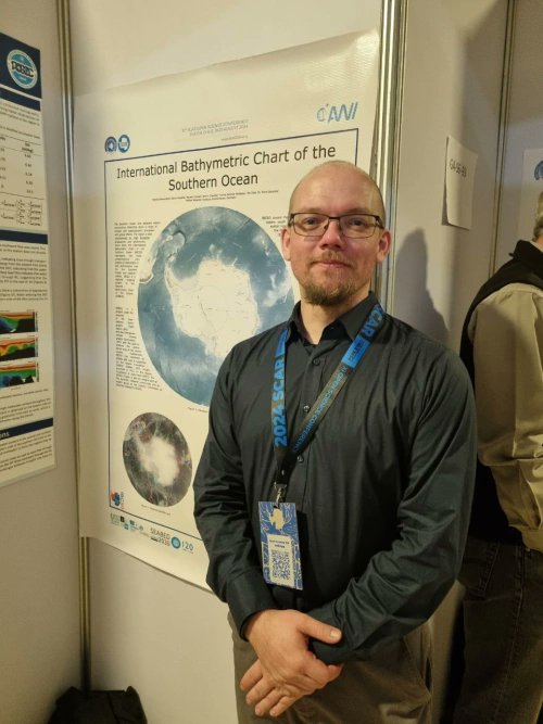
Great to take part in SCAR CHILE 2024!🇨🇱 #SCAR shapes the future of polar research and fosters global collaboration. Speaking at the event Patrick Schwarzbach from our Southern Ocean Center shared an IBCSO update on the need for more data. Learn more: ibcso.org/scar-osc-2024/

Great to take part in <a href="/scarchile2024/">SCAR CHILE 2024</a>!🇨🇱

#SCAR shapes the future of polar research and fosters global collaboration.

Speaking at the event Patrick Schwarzbach from our Southern Ocean Center shared an <a href="/ibcso/">IBCSO</a> update on the need for more data. 

Learn more: ibcso.org/scar-osc-2024/
Seabed 2030 (@seabed2030) 's Twitter Profile Photo

🤔Did you know the #Pacific region incorporates 124 million km2 of #ocean and 39 countries & territories? We value local voices and care about your work. Come share your efforts and join in discussions on 4-6 November. Secure your spot today 👉 survey123.arcgis.com/share/6dc81d59…

🤔Did you know the #Pacific region incorporates 124 million km2 of #ocean and 39 countries &amp; territories?

We value local voices and care about your work. Come share your efforts and join in discussions on 4-6 November.

Secure your spot today 👉 survey123.arcgis.com/share/6dc81d59…
Seabed 2030 (@seabed2030) 's Twitter Profile Photo

🗺️ E/V Nautilus is a key partner helping to map the gaps. Their latest expedition will contribute uncharted #seabed #data that will form part of the GEBCO grid. We’re grateful to the expedition team for their ongoing efforts. Learn more 👉 youtube.com/watch?v=tpbfKf…

Seabed 2030 (@seabed2030) 's Twitter Profile Photo

🌏 Ocean climate models aim to understand and predict future conditions on both small and large spatial scales. Seabed #mapping data can be used to enhance models, improve our understanding of #climate change and inform decisions. 👉 Swipe to learn more about the key benefits.

🌏 Ocean climate models aim to understand and predict future conditions on both small and large spatial scales.

Seabed #mapping data can be used to enhance models, improve our understanding of #climate change and inform decisions.

👉 Swipe to learn more about the key benefits.
Seabed 2030 (@seabed2030) 's Twitter Profile Photo

📣 Calling all businesses By sharing existing bathymetric #data and supporting new data collection initiatives, you can significantly advance our understanding of the #ocean floor. Start contributing👉 seabed2030.org/industry

📣 Calling all businesses

By sharing existing bathymetric #data and supporting new data collection initiatives, you can significantly advance our understanding of the #ocean floor. 

Start contributing👉 seabed2030.org/industry
Seabed 2030 (@seabed2030) 's Twitter Profile Photo

🎙️ Our Director Jamie McMichael-Phillips recently joined this phenomenal Minds Behind Maps #podcast to discuss the #Seabed2030 project and the importance of #ocean mapping. Out now: youtube.com/watch?v=rRi0UY…

Seabed 2030 (@seabed2030) 's Twitter Profile Photo

🚨 ¡Última oportunidad para presentar! 🇫🇯 Sé parte de la 6ª Reunión Anual de Cartografía del Océano Pacífico de Seabed 2030 y habla sobre todo lo relacionado con la cartografía de los fondos marinos. Regístrate ya ➡️ survey123.arcgis.com/share/6dc81d59…

🚨 ¡Última oportunidad para presentar!

🇫🇯 Sé parte de la 6ª Reunión Anual de Cartografía del Océano Pacífico de Seabed 2030 y habla sobre todo lo relacionado con la cartografía de los fondos marinos.

Regístrate ya ➡️ survey123.arcgis.com/share/6dc81d59…
Seabed 2030 (@seabed2030) 's Twitter Profile Photo

🚨 Last chance to present! 🇫🇯 Be a part of the 6th annual Seabed 2030 Pacific Ocean Mapping Meeting and speak about everything and anything around seabed mapping. Register to present now ➡️ survey123.arcgis.com/share/6dc81d59…

🚨 Last chance to present!

🇫🇯 Be a part of the 6th annual Seabed 2030 Pacific Ocean Mapping Meeting and speak about everything and anything around seabed mapping.

Register to present now ➡️ survey123.arcgis.com/share/6dc81d59…