Jonathan O'Brien (@jeobrien_wx) 's Twitter Profile
Jonathan O'Brien

@jeobrien_wx

Fire wx meteorologist @forestservice in SoCal | Fmr @NWS_MountHolly and Hollings @NWSBoston | @PlymouthState alum | Weather | Outdoors | Boston sports |

ID: 3308478845

calendar_today04-06-2015 17:52:30

1,1K Tweet

873 Takipçi

595 Takip Edilen

Jonathan O'Brien (@jeobrien_wx) 's Twitter Profile Photo

In my experience, HRRR wind gusts tend to be quite accurate. If these numbers are in the ballpark, there is devastating wind damage potential on the table for portions of the CA Central Coast, in addition to the much discussed flooding threat. Extremely dangerous storm. #CAwx

In my experience, HRRR wind gusts tend to be quite accurate. If these numbers are in the ballpark, there is devastating wind damage potential on the table for portions of the CA Central Coast, in addition to the much discussed flooding threat. Extremely dangerous storm. #CAwx
Jonathan O'Brien (@jeobrien_wx) 's Twitter Profile Photo

Oof, that is ugly ugly over Nebraska and the Texas panhandle. Massive grass/brush fires running tens of miles west to east amidst record heat and high winds… #Firewx

Jonathan O'Brien (@jeobrien_wx) 's Twitter Profile Photo

Cannot imagine being in (and hope nobody is there) Canadian, TX right now. Literal hell on earth with fire on all sides, if not in the town itself. Horrible. #FireWx

Cannot imagine being in (and hope nobody is there) Canadian, TX right now. Literal hell on earth with fire on all sides, if not in the town itself. Horrible. #FireWx
Jonathan O'Brien (@jeobrien_wx) 's Twitter Profile Photo

Understanding how rarified the air is, I don’t think it’s unfair to compare this Oklahoma storm to the 2013 El Reno storm. Some very similar storm scale dynamics in play. Thankfully it’s in a very rural area overall. Loving all the insane radar loops!

Jonathan O'Brien (@jeobrien_wx) 's Twitter Profile Photo

We’re in much better shape going into this summer than in 2020 (wet/snowy winter, lack of drought) but this also bears watching for Western US #firewx impacts late this summer/fall. Possibly a slow starting fire season that roars to life late on the back of a hot/dry summer…

Jonathan O'Brien (@jeobrien_wx) 's Twitter Profile Photo

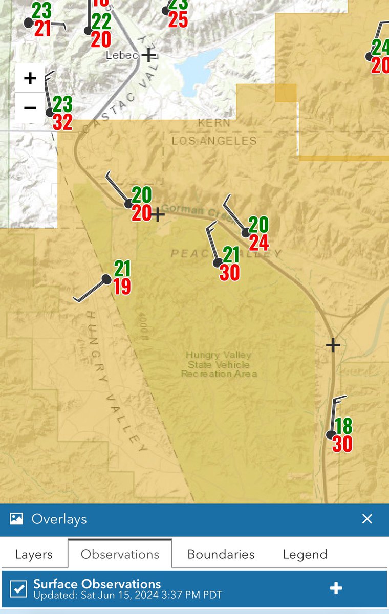
The #postfire is in a precarious spot. High wind warning in effect. RH (green) near 20%. Wind gusts (red) 20-30+ mph and will increase. And two years of rain-driven huge grass/brush fuel load. Many ground and aerial resources on it, but that’s a tough fight.

The #postfire is in a precarious spot. High wind warning in effect. RH (green) near 20%. Wind gusts (red) 20-30+ mph and will increase. And two years of rain-driven huge grass/brush fuel load. Many ground and aerial resources on it, but that’s a tough fight.
Jonathan O'Brien (@jeobrien_wx) 's Twitter Profile Photo

The #postfire looks active already this morning. This is important as grass dominated fires often “lay down” greatly overnight, allowing a big boost in containment. Not so this time with extended burn windows due to high winds/low RH. Another very tough day on the way.

The #postfire looks active already this morning. This is important as grass dominated fires often “lay down” greatly overnight, allowing a big boost in containment. Not so this time with extended burn windows due to high winds/low RH. Another very tough day on the way.
Dr. Daniel Swain (@weather_west) 's Twitter Profile Photo

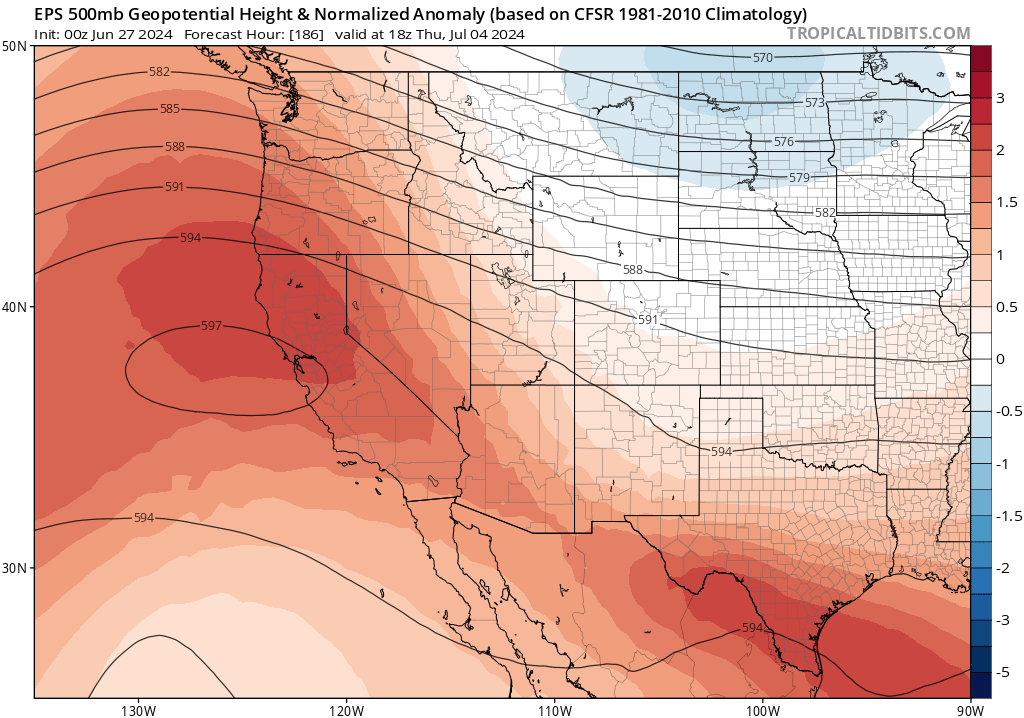
Early signs of potentially major heatwave around 4th of July centered on Northern CA, and this event could bring hot temperatures all the way to the coast (uncommon for early Jul). Early hints at potential for some record-breaking heat & very high grass/brush fire risk. #CAwx

Early signs of potentially major heatwave around 4th of July centered on Northern CA, and this event could bring hot temperatures all the way to the coast (uncommon for early Jul). Early hints at potential for some record-breaking heat & very high grass/brush fire risk. #CAwx
NWS Climate Prediction Center (@nwscpc) 's Twitter Profile Photo

A persistent, dangerous heat wave will likely continue in the West next week. Please stay hydrated and limit time outdoors in the heat! cpc.ncep.noaa.gov

A persistent, dangerous heat wave will likely continue in the West next week. Please stay hydrated and limit time outdoors in the heat! cpc.ncep.noaa.gov
Jonathan O'Brien (@jeobrien_wx) 's Twitter Profile Photo

Smoke plumes abound across CA this afternoon. We have *barely* started this heat and #FireWx event. It is going to be a long and trying next 7-10+ days for the state, both in terms of heat/human health impacts and managing what will likely be many new and existing fires.

Smoke plumes abound across CA this afternoon. We have *barely* started this heat and #FireWx event. It is going to be a long and trying next 7-10+ days for the state, both in terms of heat/human health impacts and managing what will likely be many new and existing fires.
Jonathan O'Brien (@jeobrien_wx) 's Twitter Profile Photo

Just wrapped up 2 weeks IMET’ing on the #ShellyFire in N CA. What an awesome experience - even got a trip up in a helicopter! Best news, against steep odds in brutal terrain, crews kept this one a lot smaller than it could’ve been. Was pushing hard for a few days tho!

Just wrapped up 2 weeks IMET’ing on the #ShellyFire in N CA. What an awesome experience - even got a trip up in a helicopter! Best news, against steep odds in brutal terrain, crews kept this one a lot smaller than it could’ve been. Was pushing hard for a few days tho!
Jonathan O'Brien (@jeobrien_wx) 's Twitter Profile Photo

Radar now showing pronounced column rotation on the #parkfire, backing up visual and camera observations. Extreme fire behavior

Radar now showing pronounced column rotation on the #parkfire, backing up visual and camera observations. Extreme fire behavior