Brian McNoldy (@bmcnoldy) 's Twitter Profile
Brian McNoldy

@bmcnoldy

Senior Research Associate at the Univ. of Miami Rosenstiel School. Hurricanes, climatology, & sea level rise... mostly. 🏳️‍🌈 Born at 333 ppm CO₂. Also on 🦋.

ID: 617299845

linkhttps://bmcnoldy.earth.miami.edu/ calendar_today24-06-2012 15:33:34

18,18K Tweet

28,28K Takipçi

6,6K Takip Edilen

Brian McNoldy (@bmcnoldy) 's Twitter Profile Photo

Here's another update to this chart as of Sep 3. Climatologically, only 35% of the season's ACE has occurred by now. The 2024 #HurricaneSeason's dot will fall somewhere in the orange oval (left side if nothing else forms, right side if the rest of the season goes off the rails).

Here's another update to this chart as of Sep 3. Climatologically, only 35% of the season's ACE has occurred by now.
The 2024 #HurricaneSeason's dot will fall somewhere in the orange oval (left side if nothing else forms, right side if the rest of the season goes off the rails).
Brian McNoldy (@bmcnoldy) 's Twitter Profile Photo

Curious to try out #Bluesky? If you're a #hurricane fanatic, I created a Starter Pack of folks to follow (and happy to add more!): go.bsky.app/88mXQKD

Brian McNoldy (@bmcnoldy) 's Twitter Profile Photo

A big shout-out to Philip Klotzbach and the rest of the team at CSU Atmos Sci for compiling this analysis and discussion. Many of us have been digging into this question and putting out scattered thoughts, but I like this summary and will direct people to it. tropical.colostate.edu/Forecast/2024_…

Brian McNoldy (@bmcnoldy) 's Twitter Profile Photo

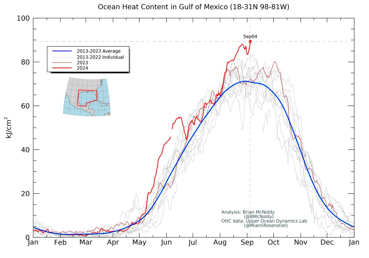
This is pretty amazing: the ocean heat content averaged over the Gulf of Mexico is obliterating previous all-time record highs. It's 126% of average for the date. bmcnoldy.earth.miami.edu/tropics/ohc/

This is pretty amazing: the ocean heat content averaged over the Gulf of Mexico is obliterating previous all-time record highs. It's 126% of average for the date.
bmcnoldy.earth.miami.edu/tropics/ohc/
Naomi Feinstein (@naomifeinstein) 's Twitter Profile Photo

With Labor Day in the rearview mirror, you are probably hoping for the end of the brutal summer heat. Unfortunately, Brian McNoldy has some bad news. miaminewtimes.com/news/when-miam…

Brian McNoldy (@bmcnoldy) 's Twitter Profile Photo

#Summer, defined here to be days when the heat index reaches 90°F+, lasts three weeks longer now (1991-2020 average) compared to four decades ago (1951-1980 average) in #Miami. miaminewtimes.com/news/when-miam… Miami New Times University of Miami Rosenstiel School

#Summer, defined here to be days when the heat index reaches 90°F+, lasts three weeks longer now (1991-2020 average) compared to four decades ago (1951-1980 average) in #Miami. miaminewtimes.com/news/when-miam…
<a href="/miaminewtimes/">Miami New Times</a> <a href="/MiamiRosenstiel/">University of Miami Rosenstiel School</a>
Brian McNoldy (@bmcnoldy) 's Twitter Profile Photo

On Wednesday, #Miami just had its 14th day this year that met the county's heat advisory criteria of a 105F+ heat index for 2+ hours. Combining the heat and humidity, 2024 is shaping up to be the 2nd-muggiest year on record, though well behind crazy 2023. bmcnoldy.earth.miami.edu/mia/

On Wednesday, #Miami just had its 14th day this year that met the county's heat advisory criteria of a 105F+ heat index for 2+ hours. Combining the heat and humidity, 2024 is shaping up to be the 2nd-muggiest year on record, though well behind crazy 2023. 
bmcnoldy.earth.miami.edu/mia/
Brian McNoldy (@bmcnoldy) 's Twitter Profile Photo

The monthly SST data are in for August (NOAA's ERSSTv5), and over the tropical Atlantic, the average SST is still keeping pace with the record-shattering 2023 values. I also highlight the SST in mega-hurricane seasons 2005 and 1933 for reference.

The monthly SST data are in for August (NOAA's ERSSTv5), and over the tropical Atlantic, the average SST is still keeping pace with the record-shattering 2023 values.  I also highlight the SST in mega-hurricane seasons 2005 and 1933 for reference.
Brian McNoldy (@bmcnoldy) 's Twitter Profile Photo

With August's SST data, we now have the next Oceanic Niño Index value, which is just a hair above zero (i.e. still ENSO-neutral). The ONI is defined by a 3-month SST anomaly in the Niño 3.4 region in the equatorial Pacific Ocean. bmcnoldy.earth.miami.edu/tropics/oni/

With August's SST data, we now have the next Oceanic Niño Index value, which is just a hair above zero (i.e. still ENSO-neutral).  The ONI is defined by a 3-month SST anomaly in the Niño 3.4 region in the equatorial Pacific Ocean.
bmcnoldy.earth.miami.edu/tropics/oni/
Brian McNoldy (@bmcnoldy) 's Twitter Profile Photo

7 years ago today, on the morning of September 5, #Irma intensified to a Category 5 hurricane for the first time. It maintained that status for an incredible 78 hours of terror. A collection of satellite & radar loops: bmcnoldy.rsmas.miami.edu/tropics/irma17…

Brian McNoldy (@bmcnoldy) 's Twitter Profile Photo

"Meteorologists predicted a busy Atlantic hurricane season—and a recent lull in activity doesn’t negate that." scientificamerican.com/article/atlant…

Brian McNoldy (@bmcnoldy) 's Twitter Profile Photo

The radar in #Haikou is centered in the eye of powerful #TyphoonYagi... and thankfully it's still up & running (so far)!! 🤞 bmcnoldy.earth.miami.edu/tropics/radar/

Republicans against Trump (@rpsagainsttrump) 's Twitter Profile Photo

New statement from former Vice President Cheney: “In our nation’s 248-year history, there has never been an individual who is a greater threat to our republic than Donald Trump. He tried to steal the last election using lies and violence to keep himself in power after the voters

New statement from former Vice President Cheney:

“In our nation’s 248-year history, there has never been an individual who is a greater threat to our republic than Donald Trump. He tried to steal the last election using lies and violence to keep himself in power after the voters