Amarillo Area OEM (@amarillooem) 's Twitter Profile
Amarillo Area OEM

@amarillooem

This is an official City of Amarillo, Texas Twitter page. Please read our Terms and Conditions by clicking on the “Website Disclaimer” link at amarillo.gov.

ID: 742472908786651140

linkhttp://oem.amarillo.gov calendar_today13-06-2016 21:45:10

1,1K Tweet

1,1K Takipçi

61 Takip Edilen

Amarillo Area OEM (@amarillooem) 's Twitter Profile Photo

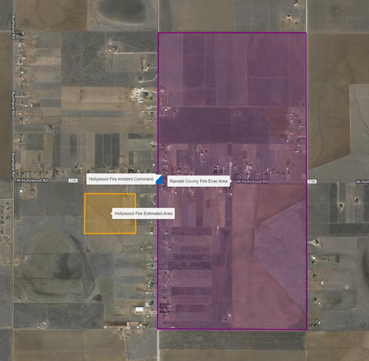
A wildfire is affecting an area that undergoing evacuations bounded by Farmers and 1 mile south of 2186 and between Blessen Rd and Hill Rd. Please evacuate if you are near this area and avoid the area so that units can work the fire.

Amarillo Area OEM (@amarillooem) 's Twitter Profile Photo

The AAOEM EOC is activated for a wildfire causing evacuations in an area bounded by Blessen Rd. and Hill Rd. & Farmers to the north & 1 mile south of 2186 (Hollywood) to the south. Evacuations are voluntary & recommended in this area. Please avoid the area & areas to the south.

The AAOEM EOC is activated for a wildfire causing evacuations in an area bounded by Blessen Rd. and Hill Rd. & Farmers to the north & 1 mile south of 2186 (Hollywood) to the south.
Evacuations are voluntary & recommended in this area. Please avoid the area & areas to the south.
Amarillo Area OEM (@amarillooem) 's Twitter Profile Photo

The wildfire is 70% contained & citizens that were evacuated will be able to return to their homes at 5PM. Amazing work by all fire departments including Randall County FD, Potter County FR, Amarillo FD, Canyon FD, Village of Palisades FD, Village of Lake Tanglewood FD, and Texas

Amarillo Area OEM (@amarillooem) 's Twitter Profile Photo

The Hollywood (Randall Co) wildfire is 70% contained & citizens evacuated will be able to return to their homes at 5PM. Amazing work by all local fire depts - Randall County FD, Potter Co Fire-Rescue, AmarilloFire, Canyon FD, Palisades FD, Lake Tanglewood FD, & Texas A&M Forest Service!!

Amarillo Area OEM (@amarillooem) 's Twitter Profile Photo

Our dispatch centers are getting many calls about the smell of smoke outside. This smoke & smell is from fires in Oklahoma that are being brought into Amarillo via a cold front.

Amarillo Area OEM (@amarillooem) 's Twitter Profile Photo

Extremely strong winds & conditions today including gusts of over 60MPH will make travel very hazardous & could lead to a potentially life-threatening wildfire event. Please do not conduct any activities that could spark a fire outside.

Amarillo Area OEM (@amarillooem) 's Twitter Profile Photo

When sirens sound, will you be ready? 🚨 AAOEM presents its new Series on Sirens! With the arrival of spring, severe weather is always a possibility. We want our residents to be prepared for & the outdoor warning siren system is a primary tool. Episode 1: bit.ly/3K4Y8Qr

Amarillo Area OEM (@amarillooem) 's Twitter Profile Photo

The National Weather Service has issued a Severe Thunderstorm watch for the Amarillo Area until 10PM. Severe weather is likely with baseball-size hail and damaging winds a possibility.

Amarillo Area OEM (@amarillooem) 's Twitter Profile Photo

The Amarillo Area is under a Severe Thunderstorm Watch until 11PM. Tornadoes & baseball-size hail (or larger) is possible. Please stay weather aware!

Amarillo Area OEM (@amarillooem) 's Twitter Profile Photo

Amarillo Area O E M is sounding sirens in Bushland for a hail threat with hail as large as baseballs. Please seek shelter immediately!

Amarillo Area OEM (@amarillooem) 's Twitter Profile Photo

Our area is under a Severe Thunderstorm Watch from now until 11PM. Damaging winds and moderate hail (1.75") are possible. Please stay weather aware!

Amarillo Area OEM (@amarillooem) 's Twitter Profile Photo

The Amarillo area is under a threat of significant flooding with rain forecast in the amount of 2 to 4 inches over the next two days. Palo Duro Canyon is under a Flood Watch. Please do not drive into flooded roadways. Turn around don't drown.

NWS Amarillo (@nwsamarillo) 's Twitter Profile Photo

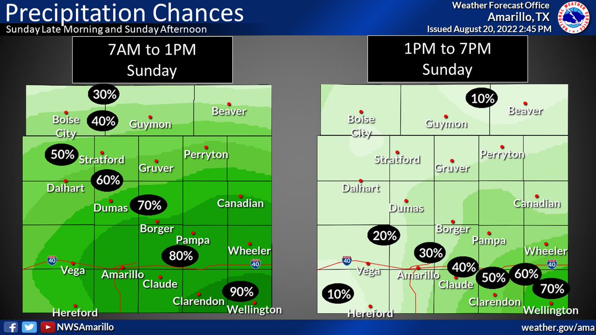
8/20/2022 The chance for rain peaks late tonight into early morning tomorrow. Rain chances will start to dwindle late tomorrow with maybe some lingering showers overnight into early Monday morning. #phwx #okwx #txwx

8/20/2022
The chance for rain peaks late tonight into early morning tomorrow. Rain chances will start to dwindle late tomorrow with maybe some lingering showers overnight into early Monday morning. #phwx #okwx #txwx