Alex Singleton (@alexsingleton) 's Twitter Profile
Alex Singleton

@alexsingleton

Prof GISc at the University of Liverpool; Author of Urban Analytics (amzn.to/2l5txth) bsky.app/profile/alexsi…

ID: 6338922

linkhttp://www.alex-singleton.com calendar_today26-05-2007 11:31:06

6,6K Tweet

4,4K Followers

1,1K Following

University of Liverpool News (@livuninews) 's Twitter Profile Photo

NEWS | Researchers from @InstPopMusic and Geography&Planning have secured a substantial grant for a ground breaking project which will develop an automated system for gathering and analysing live music data to benefit industry partners and policy makers 🎶 👉news.liverpool.ac.uk/2024/11/22/uni…

NEWS | Researchers from @InstPopMusic and <a href="/LivUniGPS/">Geography&Planning</a> have secured a substantial grant for a ground breaking project which will develop an automated system for gathering and analysing live music data to benefit industry partners and policy makers 🎶

👉news.liverpool.ac.uk/2024/11/22/uni…
Alex Singleton (@alexsingleton) 's Twitter Profile Photo

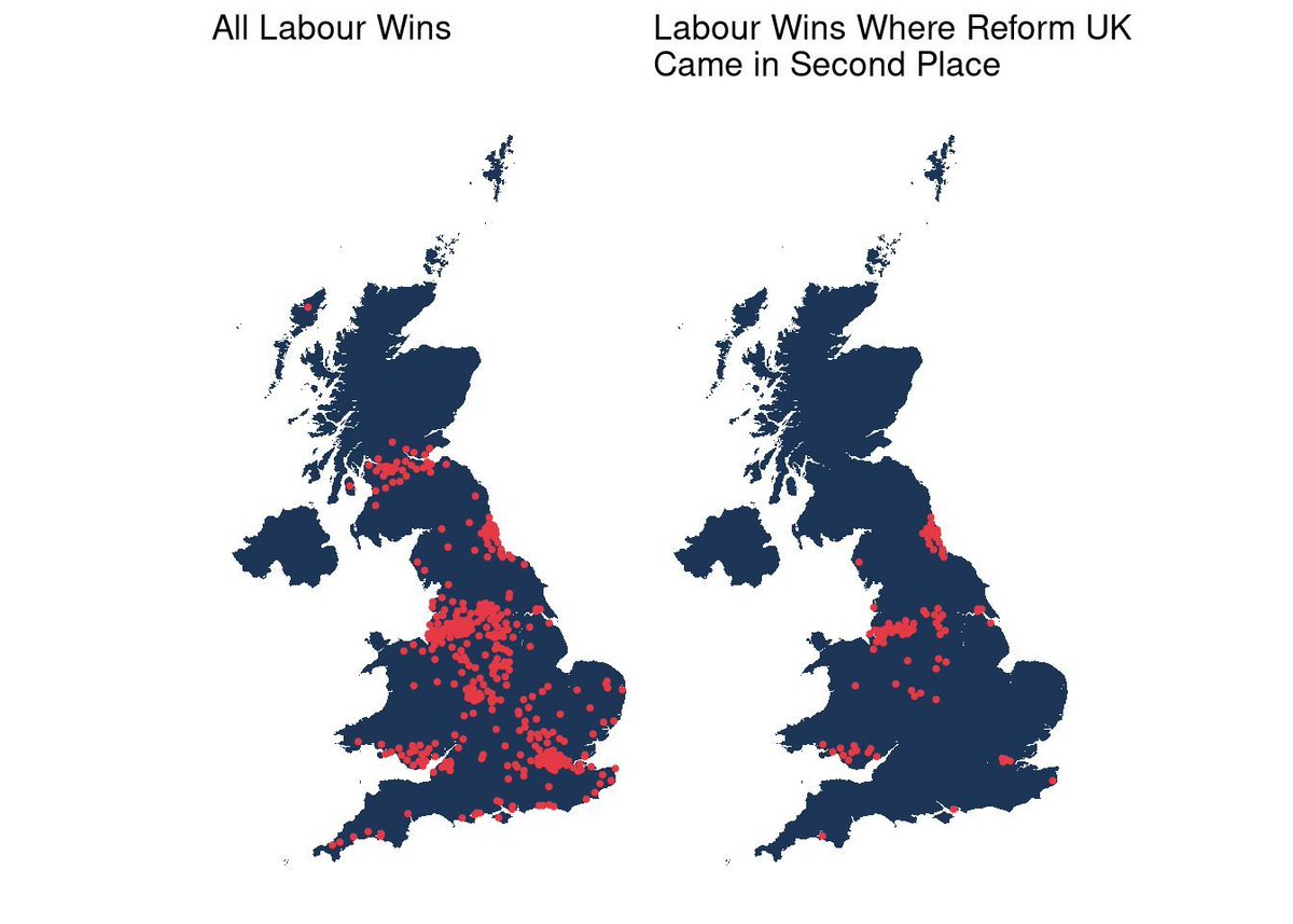
Day 22 #30DayMapChallenge - 2 Colours This map was created in #rstats and features just 2 colours. Left is where Labour were the majority party in the 2024 UK General Election. The map on the right is the subset where the Reform party held second place! buff.ly/4fMLvKn

Day 22 #30DayMapChallenge - 2 Colours
This map was created in #rstats and features just 2 colours. Left is where Labour were the majority party in the 2024 UK General Election. The map on the right is the subset where the Reform party held second place!

buff.ly/4fMLvKn
Alex Singleton (@alexsingleton) 's Twitter Profile Photo

Day 23 #30DayMapChallenge - Memory I have taken a collective view on this topic today. This is a map of cognitive geography and place associations extracted from some work looking at where people talk about on Reddit. buff.ly/4fK7scG

Day 23 #30DayMapChallenge - Memory
I have taken a collective view on this topic today. This is a map of cognitive geography and place associations extracted from some work looking at where people talk about on Reddit.

buff.ly/4fK7scG
Alex Singleton (@alexsingleton) 's Twitter Profile Photo

Day 24 #30DayMapChallenge - Only circular shapes This is another #rstats post which uses Ordnance Survey greenspace data and a simple accessibility measure to map proximity to an allotment in Greater London. The circles are scaled by their proximity. buff.ly/3UO8RqX

Day 24 #30DayMapChallenge - Only circular shapes 

This is another #rstats post which uses Ordnance Survey greenspace data and a simple accessibility measure to map proximity to an allotment in Greater London. The circles are scaled by their proximity.

buff.ly/3UO8RqX
Alex Singleton (@alexsingleton) 's Twitter Profile Photo

Day 25 #30DayMapChallenge - Heat Staying warm is difficult for many people as the price of heating their homes has risen in the UK. In this work we explored the geography of gas consumption trends in the residential sector across England and Wales. buff.ly/3O3G3qD

Day 25 #30DayMapChallenge - Heat
Staying warm is difficult for many people as the price of heating their homes has risen in the UK. In this work we explored the geography of gas consumption trends in the residential sector across England and Wales.

buff.ly/3O3G3qD
Alex Singleton (@alexsingleton) 's Twitter Profile Photo

Day 26 #30DayMapChallenge - Map Projections Today is a quick #rstats exploration that compares areas to explore distortion between two projections - the Eckert IV projection and the Mercator projection. buff.ly/3AtWv0f

Day 26 #30DayMapChallenge - Map Projections

Today is a quick #rstats exploration that compares areas to explore distortion between two projections - the Eckert IV projection and the Mercator projection.

buff.ly/3AtWv0f
Alex Singleton (@alexsingleton) 's Twitter Profile Photo

Day 27 #30DayMapChallenge - Micromapping This is a quick example of using #rstats to produce cartography from OpenStreetMap. In this instance a map is create for my local park. buff.ly/3UOEQqY

Day 27 #30DayMapChallenge - Micromapping
This is a quick example of using #rstats to produce cartography from OpenStreetMap. In this instance a map is create for my local park.

buff.ly/3UOEQqY
Alex Singleton (@alexsingleton) 's Twitter Profile Photo

Day 28 #30DayMapChallenge - The Blue Planet One of the most popular CDRC open data products is our Access to Healthy Assets and Hazards index. This includes a measure of access to bluespace. The blog post contains links to the interactive version. buff.ly/3Z0OLw2

Day 28 #30DayMapChallenge - The Blue Planet
One of the most popular CDRC open data products is our Access to Healthy Assets and Hazards index. This includes a measure of access to bluespace. The blog post contains links to the interactive version.

buff.ly/3Z0OLw2
Alex Singleton (@alexsingleton) 's Twitter Profile Photo

Day 29 #30DayMapChallenge - Overture We have been working with these data quite a bit since they arrived and have created ETL to produce an updatable POI dataset for the UK. This #rstats map illustrates how you can use these data to map coffee shops. buff.ly/4emTH2I

Day 29 #30DayMapChallenge - Overture
We have been working with these data quite a bit since they arrived and have created ETL to produce an updatable POI dataset for the UK. This #rstats map illustrates how you can use these data to map coffee shops.

buff.ly/4emTH2I
Alex Singleton (@alexsingleton) 's Twitter Profile Photo

Day 30 #30DayMapChallenge - Final Map Todays map is an exploration of small area Gross Value Added (GVA) data in England and was an excuse to look at these in the context of retail centres. All #rstats code provided, but a bit rough! buff.ly/3YPe1Ux

Day 30 #30DayMapChallenge - Final Map

Todays map is an exploration of small area Gross Value Added (GVA) data in England and was an excuse to look at these in the context of retail centres. All #rstats code provided, but a bit rough! 

buff.ly/3YPe1Ux
Alex Singleton (@alexsingleton) 's Twitter Profile Photo

🚀 Job Alert!!! 🚀 The first in a series of long term posts within the Geographic Data Service which will launch next year -this one is based in UCL- buff.ly/4fSyChU - and builds on the work that we have done over the past ten years as part of the CDRC. Deadline 12th Dec

🚀 Job Alert!!! 🚀 The first in a series of long term posts within the Geographic Data Service which will launch next year -this one is based in UCL- buff.ly/4fSyChU  - and builds on the work that we have done over the past ten years as part of the CDRC. Deadline 12th Dec
Alex Singleton (@alexsingleton) 's Twitter Profile Photo

Who fancies coming to do a PhD with me in the newly established geods.ac.uk - the topic is "AI and Geodemographics".... UK Students only unfortunately - but a great opportunity to join our exciting team - findaphd.com/phds/project/a…

Alex Singleton (@alexsingleton) 's Twitter Profile Photo

Exciting PhD opportunity alert!!!! 👇👇👇🌶️🌶️geods.ac.uk/2025/04/22/ful…🌶️🌶️ #AI #GIS #DataScientist #GeoAI

Exciting PhD opportunity alert!!!! 👇👇👇🌶️🌶️geods.ac.uk/2025/04/22/ful…🌶️🌶️ #AI #GIS #DataScientist #GeoAI
Cameron Ward (@c_ward_98) 's Twitter Profile Photo

Delighted to share that the 2nd paper from my PhD has now been published in Regional Studies Regional Science! Regional Studies, Regional Science (RSRS) Special thanks to my supervisors for their input Alex Singleton, Caitlin Robinson and Francisco Rowe ✌️. Check it out! 👇👇👇 tandfonline.com/doi/full/10.10….

Alex Singleton (@alexsingleton) 's Twitter Profile Photo

Exciting news today from our Geographic Data Service team - who doesn’t want access to a load of geographic and consumer data: linkedin.com/posts/geograph…

Alex Singleton (@alexsingleton) 's Twitter Profile Photo

If you are in the market for an exciting new data science job, I am recruiting for two Senior Data Scientists at the Geographic Data Service 👇👇👇👇👇 linkedin.com/posts/geograph…