Aaron Serre (@aaronserrewx) 's Twitter Profile
Aaron Serre

@aaronserrewx

UAH Atmospheric Science ‘26 | FSU Alum | @NWSHuntsville Pathways

ID: 888502325157015553

calendar_today21-07-2017 20:53:56

1,1K Tweet

242 Takipçi

356 Takip Edilen

NWS Huntsville (@nwshuntsville) 's Twitter Profile Photo

4:30p⚠️Active Weather Later This Week THURSDAY: Low threat for strong/severe storms, mainly for those south of the TN River between 10am - 7pm. 🧵1/3 #HUNwx

4:30p⚠️Active Weather Later This Week

THURSDAY: Low threat for strong/severe storms, mainly for those south of the TN River between 10am - 7pm. 

🧵1/3
#HUNwx
NWS Birmingham (@nwsbirmingham) 's Twitter Profile Photo

Here is the latest on the severe weather potential for central Alabama over the next few days, in Question and Answer format. #alwx

Here is the latest on the severe weather potential for central Alabama over the next few days, in Question and Answer format. #alwx
National Weather Service (@nws) 's Twitter Profile Photo

❗️🧵This weekend brings the likelihood of dangerous severe weather (details in thread) Preparation should be completed now - before weather strikes: ✅Know your safe place ✅Assemble an emergency kit ✅Write a family plan ✅Practice drills at home and work ✅Have multiple ways

NWS Birmingham (@nwsbirmingham) 's Twitter Profile Photo

When you make your safety plan, don't forget your pets! Take a picture of you AND your pet in case you get separated. And make sure you have them in a place you can easily move them if a storm approaches. Don't forget their medicines and food in your safety kit!

When you make your safety plan, don't forget your pets! Take a picture of you AND your pet in case you get separated. And make sure you have them in a place you can easily move them if a storm approaches. Don't forget their medicines and food in your safety kit!
NWS Huntsville (@nwshuntsville) 's Twitter Profile Photo

715am: Here's our thinking on timing of Round 2 storms later today, give or take an hour. Take the time now to prepare your shelter locations, and have more than 1 way to receive warnings when we issue them later today. Stay safe, and we'll all get through this together! #HUNwx

715am: Here's our thinking on timing of Round 2 storms later today, give or take an hour. Take the time now to prepare your shelter locations, and have more than 1 way to receive warnings when we issue them later today. Stay safe, and we'll all get through this together! #HUNwx
FSU Alert (@fsualert) 's Twitter Profile Photo

This is a Emergency Message for Florida State University Tallahassee Campus. Continue to shelter in place. Police have responded to an active shooter call at the Student Union. Stay alert for more information. Persons in need of immediate emergency ass manager.everbridge.net/pub/1998810670…

FSU Alert (@fsualert) 's Twitter Profile Photo

This is a Emergency Message for Florida State University Tallahassee Campus. Continue to shelter in place. Police have responded to an active shooter call at the Student Union. Stay alert for more information. Persons in need of immediate emergency ass manager.everbridge.net/pub/1986922201…

Aaron Serre (@aaronserrewx) 's Twitter Profile Photo

This is such heartbreaking news to hear at FSU. Thoughts and prayers to all FSU family and friends, as well as those impacted 🙏

Tallahassee Police (@tallypd) 's Twitter Profile Photo

The Florida State University campus has been secured. Multiple law enforcement agencies remain on site for the ongoing investigation. The Student Union & surrounding area are still considered an active crime scene. Individuals should not return to the area for any reason. (1/2)

Florida State University (@floridastate) 's Twitter Profile Photo

Florida State University will hold a Gathering of Unity Vigil at 5 p.m. Friday, April 18, on Langford Green in front of the Unconquered Statue. The FSU community is invited to come together to mourn the victims and everyone who has been affected by this tragedy. This event is an

Florida State University will hold a Gathering of Unity Vigil at 5 p.m. Friday, April 18, on Langford Green in front of the Unconquered Statue. The FSU community is invited to come together to mourn the victims and everyone who has been affected by this tragedy. This event is an
NWS Huntsville (@nwshuntsville) 's Twitter Profile Photo

Okay y'all... we have some bad news. Our radar in Hytop, AL has gone down. Our technicians are aware and we have surrounding radars and research radars helping our radar operators. We are still able to issue warnings and will be here around the clock to keep everyone safe.

Okay y'all... we have some bad news. Our radar in Hytop, AL has gone down. Our technicians are aware and we have surrounding radars and research radars helping our radar operators. We are still able to issue warnings and will be here around the clock to keep everyone safe.
NWS Huntsville (@nwshuntsville) 's Twitter Profile Photo

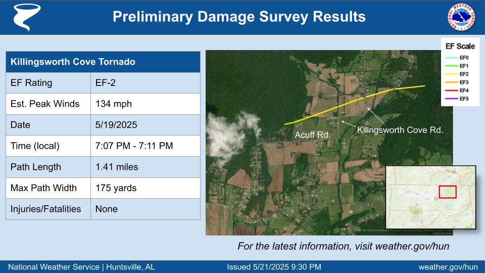
9:30 PM: Preliminary Storm Surveys - Tornadoes in Madison and Limestone Counties, and wind damage in many portions of Colbert, Lauderdale, Lawrence, and Limestone Counties. Additional surveying may necessitate changes to these tornado tracks. #HUNwx

9:30 PM:  Preliminary Storm Surveys - Tornadoes in Madison and Limestone Counties, and  wind damage in many portions of Colbert, Lauderdale, Lawrence, and Limestone Counties.  Additional surveying may necessitate changes to these tornado tracks.  #HUNwx
National Weather Service (@nws) 's Twitter Profile Photo

Over the past 3 days of this eastern U.S. heat wave, hundreds of record highs have been broken from the Plains to the East Coast. Many more are possible today, before a cold front, and showers and storms start to back down the extreme heat. weather.gov/heat

Over the past 3 days of this eastern U.S. heat wave, hundreds of record highs have been broken from the Plains to the East Coast. Many more are possible today, before a cold front, and showers and storms start to back down the extreme heat.

weather.gov/heat
National Weather Service (@nws) 's Twitter Profile Photo

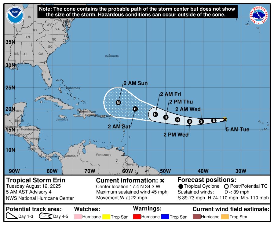
It is still too early to determine what impacts, if any, Erin may bring to the northern Leeward Islands, Bermuda, or the east coast of the United States. As we approach the climatological peak of the hurricane season, this is an opportune time to ensure your preparedness plans

It is still too early to determine what impacts, if any, Erin may bring to the northern Leeward Islands, Bermuda, or the east coast of the United States. As we approach the climatological peak of the hurricane season, this is an opportune time to ensure your preparedness plans