Rob Witter (@witterbanter) 's Twitter Profile
Rob Witter

@witterbanter

skier, runner, dad, earthquake geologist, tweets my own

ID: 286758924

calendar_today23-04-2011 16:53:09

1,1K Tweet

615 Takipçi

297 Takip Edilen

Emily Schwing (@emilyschwing) 's Twitter Profile Photo

Alaska Native leaders are calling on Governor Mike Dunleavy to request a federal disaster declaration to release federal funds to aid in #merbok disaster recovery. A spokesman for Alaska DHS&EM told me they "don't see the need for federal assets to respond to the impacts of the storm.”

Jason "Jay" R. Patton (@patton_cascadia) 's Twitter Profile Photo

#EarthquakeReport for M 7.6 #Sismo #Terremoto #Earthquake offshore of #Colima #Michoacan border en #Mexico PAGER alert estimates lots of damage and Sadly lots of suffering Shaking intensity modeled to abt MMI 8 or 9. No reports exceeding MMI7 yet earthquake.usgs.gov/earthquakes/ev…

#EarthquakeReport for M 7.6 #Sismo #Terremoto #Earthquake offshore of #Colima #Michoacan border en #Mexico

PAGER alert estimates lots of damage and Sadly lots of suffering 

Shaking intensity modeled to abt MMI 8 or 9. No reports exceeding MMI7 yet

earthquake.usgs.gov/earthquakes/ev…
Geosciences at VT (@vtgeosciences) 's Twitter Profile Photo

David Bruce and Jessica DePaolis, PhD students in the Coastal Hazards Lab with Tina Dura, traveled to north-central Chile this summer to describe and measure the 9/16/2015 tsunami deposit. The samples collected will undergo more detailed analyses in the lab this school year. 🧵

David Bruce and Jessica DePaolis, PhD students in the Coastal Hazards Lab with <a href="/diatomdura/">Tina Dura</a>, traveled to north-central Chile this summer to describe and measure the 9/16/2015 tsunami deposit. The samples collected will undergo more detailed analyses in the lab this school year. 🧵
Tina Dura (@diatomdura) 's Twitter Profile Photo

Cascadia paleoseismic fieldwork at the Sixes River in southern Oregon. It’s a dream to be here with the Sixes River OG paleoseismologists Rob Witter and Harvey Kelsey. Our mission is to collect new vibracores for quantitative diatom analysis 🌊

Cascadia paleoseismic fieldwork at the Sixes River in southern Oregon. It’s a dream to be here with the Sixes River OG paleoseismologists Rob Witter and Harvey Kelsey. Our mission is to collect new vibracores for quantitative diatom analysis 🌊
AGU's Eos (@agu_eos) 's Twitter Profile Photo

Tsunami update from Rob Witter Rich Briggs Tina Dura Simon Engelhart USGS Earthquakes USGS Alaska Geosciences at VT. New research indicates that the Aleutians, cradle of Pacific tsunamis, launch dangerous waves every 60–90 years, on average. eos.org/features/seism…
Tina Dura (@diatomdura) 's Twitter Profile Photo

Good thing I’m here on this Cascadia paleoseismology fieldwork, no one else could get this core out of the ground!* Rob Witter @_sourcetosink seismicdave Geosciences at VT #cascadiasubductionzone #tsunamis #earthquakes *Parts of this story may have been exaggerated.

Good thing I’m here on this Cascadia paleoseismology fieldwork, no one else could get this core out of the ground!* <a href="/WitterBanter/">Rob Witter</a> @_sourcetosink <a href="/seismicdave1/">seismicdave</a> <a href="/vtgeosciences/">Geosciences at VT</a> #cascadiasubductionzone #tsunamis #earthquakes 

*Parts of this story may have been exaggerated.
Rob Witter (@witterbanter) 's Twitter Profile Photo

Reconstructing past earthquake upheaval (and coastal subsidence) at Cape Blanco with ⁦Geosciences at VT⁩ paleoseismologists Tina Dura Tina Dura and students David Bruce Dave Farrant and Mike Priddy ⁦@_sourcetosink⁩

Reconstructing past earthquake upheaval (and coastal subsidence) at Cape Blanco with ⁦<a href="/vtgeosciences/">Geosciences at VT</a>⁩ paleoseismologists Tina Dura <a href="/diatomdura/">Tina Dura</a> and students David Bruce <a href="/seismicdave/">Dave Farrant</a> and Mike Priddy ⁦@_sourcetosink⁩
Tina Dura (@diatomdura) 's Twitter Profile Photo

Check out our new article in EOS reviewing over a decade of coastal paleoseismology work along the Alaska-Aleutian subduction zone and how it informs tsunami hazard assessments in the Pacific region 🌊🧵 eos.org/features/seism…

USGS (@usgs) 's Twitter Profile Photo

Pacific coastal communities have experienced several devastating tsunamis over the past few decades. Some of the most dangerous started from earthquakes along Alaska’s Aleutian Islands between 1938-65. Learn more: ow.ly/yzOO50LuCTN #worldtsunamiawarenessday USGS Alaska
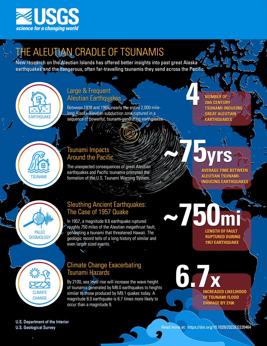
Pacific coastal communities have experienced several devastating tsunamis over the past few decades. Some of the most dangerous started from earthquakes along Alaska’s Aleutian Islands between 1938-65. Learn more: ow.ly/yzOO50LuCTN #worldtsunamiawarenessday <a href="/USGS_Alaska/">USGS Alaska</a>
Harold Tobin (@harold_tobin) 's Twitter Profile Photo

Years in the making, the SZ4D Implementation Plan is out! This is the culmination of the SZ4D and MCS Research Coordination Networks - and also the opening of the next chapter for this massive community effort.

USGS Coastal Change (@usgscoastchange) 's Twitter Profile Photo

"Geologists can't predict exactly when, where, or how big the next earthquake and tsunami might be, but we can use evidence of past tsunamis to figure out how often these events occur, and how large potential future tsunamis might be." Learn more here: ow.ly/C2NJ50M3CEQ

Tina Dura (@diatomdura) 's Twitter Profile Photo

SSA 2024 session alert! Join us in Anchorage for "From Faults to Fjords: Earthquake Evidence in Terrestrial and Subaqueous Environments." We seek presentations that highlight paleoseismic records from all depositional environments/laboratory analyses/ modeling studies/syntheses.

SSA 2024 session alert! Join us in Anchorage for "From Faults to Fjords: Earthquake Evidence in Terrestrial and Subaqueous Environments." We seek presentations that highlight paleoseismic records from all depositional environments/laboratory analyses/ modeling studies/syntheses.