Jeff Berardelli (@weatherprof) 's Twitter Profile
Jeff Berardelli

@weatherprof

WFLA-TV (Tampa Bay) Chief Meteorologist and Climate Specialist. BS Atmospheric Sciences Cornell U. MA Climate Columbia U. Past CBS News NY and Miami, Tampa, WPB

ID: 963157886

linkhttp://WFLA.com calendar_today21-11-2012 21:55:14

38,38K Tweet

47,47K Followers

9,9K Following

Ed Piotrowski (@edpiotrowski) 's Twitter Profile Photo

IS THE 2024 HURRICANE SEASON A BUST? It's time to address the elephant in the room. There's no denying the forecasts from multiple agencies for an extremely active hurricane season are in serious jeopardy. We're near the peak of hurricane season, and we haven't had a named

IS THE 2024 HURRICANE SEASON A BUST?

It's time to address the elephant in the room. There's no denying the forecasts from multiple agencies for an extremely active hurricane season are in serious jeopardy.  We're near the peak of hurricane season, and we haven't had a named
Scott Sistek (@scottseattlewx) 's Twitter Profile Photo

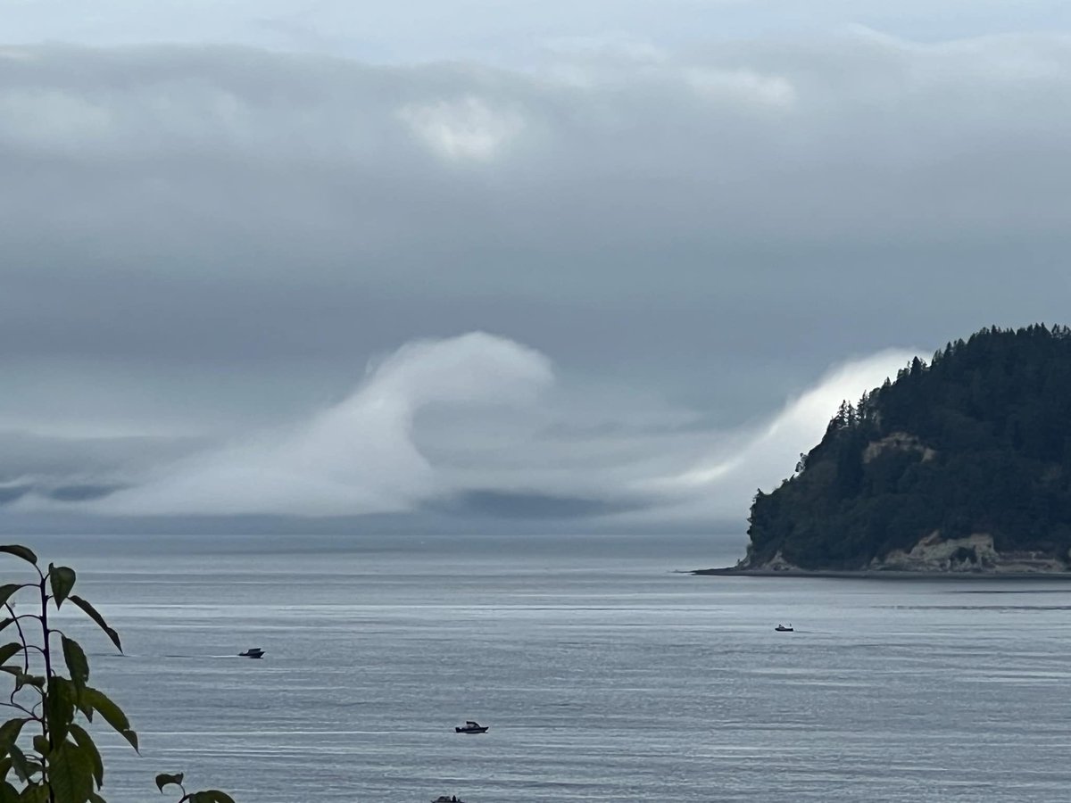
Epic Kelvin-Helmholtz cloud display in the fog Tuesday over Puget Sound just off Whidbey Island 😮 #wawx (Photo courtesy: Jodi Poissant)

Epic Kelvin-Helmholtz cloud display in the fog Tuesday over Puget Sound just off Whidbey Island 😮 #wawx 

(Photo courtesy: Jodi Poissant)
Jeff Berardelli (@weatherprof) 's Twitter Profile Photo

Widespread heavy rain in Tampa/ St Pete today. The winner (or loser) so far is Bay Pines/ Seminole with 7” in just a few hours. Roads are flooded everywhere. Be safe!

Widespread heavy rain in Tampa/ St Pete today. The winner (or loser) so far is Bay Pines/ Seminole with 7” in just a few hours. Roads are flooded everywhere. Be safe!
Jeff Berardelli (@weatherprof) 's Twitter Profile Photo

Are extreme rains increasing? The answer is yes. This analysis shows Tampa but does not include the past two days. You can see the most extreme rain events (green colors) are trending upward significantly as the climate warms. Analysis thanks to Sunil Nagaraj weathersight !!

Are extreme rains increasing? The answer is yes. This analysis shows Tampa but does not include the past two days.
You can see the most extreme rain events (green colors) are trending upward significantly as the climate warms. Analysis thanks to <a href="/sunil_nagaraj/">Sunil Nagaraj</a> <a href="/weathersightio/">weathersight</a> !!
Jeff Berardelli (@weatherprof) 's Twitter Profile Photo

Tonight after Football we reveal the results of an exclusive localized climate change-hurricane WFLA NEWS study done with Dept of Energy. We looked at how hurricane risk will change along the Gulf & SE coast the 2nd half of this century. Even for me, the results were stunning.

Mark Parrington (@m_parrington) 's Twitter Profile Photo

The huge scale of South America #wildfires continues to grow faster than usual towards the typical seasonal peak. 1 Jan to 4 Sept total estimated emissions highest for Bolivia🇧🇴 since 2010 for Brazil🇧🇷 for 2024 in the 22-year #CopernicusAtmosphere GFAS dataset 🧵1/2

The huge scale of South America #wildfires continues to grow faster than usual towards the typical seasonal peak. 1 Jan to 4 Sept total estimated emissions highest for Bolivia🇧🇴 since 2010 for Brazil🇧🇷 for 2024 in the 22-year #CopernicusAtmosphere GFAS dataset 🧵1/2
Jeff Berardelli (@weatherprof) 's Twitter Profile Photo

Talk about whiplash!! After 2 days in a row with top ten hourly rainfall records in Tampa, we now have 59” of rain for the year so far, 9 inches above our normal total yearly rainfall with 4 months left to go. Last year we couldn’t buy a drop of rain with only 24” by this date.

Talk about whiplash!! 
After 2 days in a row with top ten hourly rainfall records in Tampa, we now have 59” of rain for the year so far, 9 inches above our normal total yearly rainfall with 4 months left to go.
Last year we couldn’t buy a drop of rain with only 24” by this date.
Jeff Berardelli (@weatherprof) 's Twitter Profile Photo

What a difference a year makes in Sarasota! To date we’ve had 60”, while last year at this time we only had 20”…3X more! From the driest year on record to likely one of the wettest.

What a difference a year makes in Sarasota! To date we’ve had 60”, while last year at this time we only had 20”…3X more! From the driest year on record to likely one of the wettest.
Jeff Berardelli (@weatherprof) 's Twitter Profile Photo

The air is getting more moist as Earth warms. This is a view of surface moisture (dewpoint) rankings for summer. Blue shading is the highest rankings on record. As a planet, this summer was number 1.