WKRG Grant Skinner(@WKRGgrant) 's Twitter Profileg
WKRG Grant Skinner

@WKRGgrant

Weekend Evening Meteorologist/Digital Reporter @WKRG | Nashville Native | @uofsouthalabama Alum | [email protected]

ID:1281023949044924432

linkhttps://www.wkrg.com/author/grant-skinner/ calendar_today09-07-2020 00:35:45

2,5K Tweets

781 Followers

599 Following

WKRG Grant Skinner(@WKRGgrant) 's Twitter Profile Photo

We are set for another chilly night, but those afternoons will get warmer and warmer in the week ahead. tinyurl.com/3pjrd349
WKRG

We are set for another chilly night, but those afternoons will get warmer and warmer in the week ahead. tinyurl.com/3pjrd349 @WKRG #alwx #flwx #mswx
account_circle
WKRG Grant Skinner(@WKRGgrant) 's Twitter Profile Photo

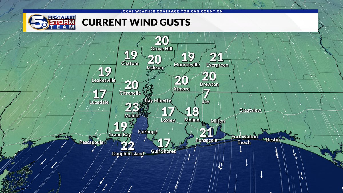
A cooler start with sunny skies and less humidity! Highs will be in the low-to-mid 70's this afternoon. It will be breezy out there with gusts between 15-20 mph. Details below!

MORE: shorturl.at/cqKMT

A cooler start with sunny skies and less humidity! Highs will be in the low-to-mid 70's this afternoon. It will be breezy out there with gusts between 15-20 mph. Details below! MORE: shorturl.at/cqKMT
account_circle
WKRG Grant Skinner(@WKRGgrant) 's Twitter Profile Photo

Tonight will be chilly with wind chills dropping into the upper-30's and low-40's across much of the area! Lots of sunshine and mild temps are in store for Monday, and we will gradually warm up throughout the week.

The latest forecast: tinyurl.com/3pjrd349

Tonight will be chilly with wind chills dropping into the upper-30's and low-40's across much of the area! Lots of sunshine and mild temps are in store for Monday, and we will gradually warm up throughout the week. The latest forecast: tinyurl.com/3pjrd349
account_circle
WKRG Grant Skinner(@WKRGgrant) 's Twitter Profile Photo

A few showers and storms will linger through the early afternoon. Afterwards, skies will clear, and cooler and drier air will be ushered in, setting us up for a beautiful start to the new work week. Full Forecast: tinyurl.com/5dp9smer

A few showers and storms will linger through the early afternoon. Afterwards, skies will clear, and cooler and drier air will be ushered in, setting us up for a beautiful start to the new work week. Full Forecast: tinyurl.com/5dp9smer
account_circle
WKRG Grant Skinner(@WKRGgrant) 's Twitter Profile Photo

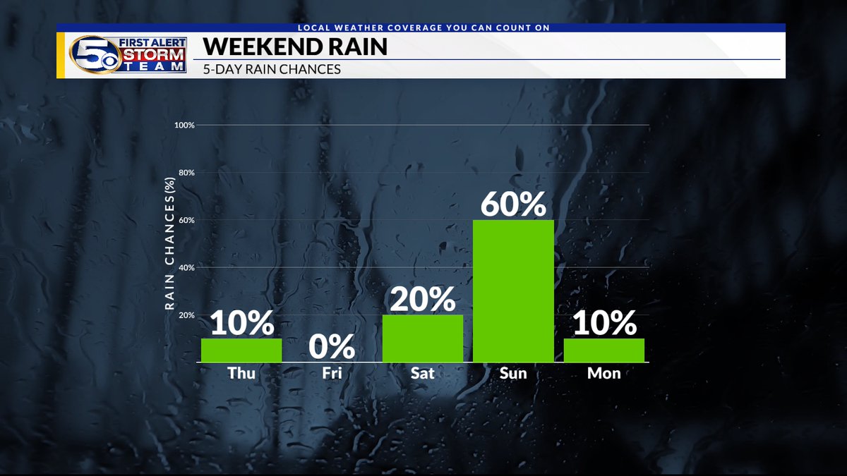
After scattered showers and storms this evening, we will have a brief break before more widespread rain is expected into Sunday morning. By Sunday evening, rain chances drop off, and cooler and drier air returns.

Full Forecast: tinyurl.com/3pjrd349

After scattered showers and storms this evening, we will have a brief break before more widespread rain is expected into Sunday morning. By Sunday evening, rain chances drop off, and cooler and drier air returns. Full Forecast: tinyurl.com/3pjrd349
account_circle
WKRG Grant Skinner(@WKRGgrant) 's Twitter Profile Photo

A Severe T-Storm Warning has been issued until 7:15 p.m. for northern Escambia and Conecuh counties in Alabama. 60 mph wind gusts and quarter size hail are possible.

A Severe T-Storm Warning has been issued until 7:15 p.m. for northern Escambia and Conecuh counties in Alabama. 60 mph wind gusts and quarter size hail are possible.
account_circle
WKRG Grant Skinner(@WKRGgrant) 's Twitter Profile Photo

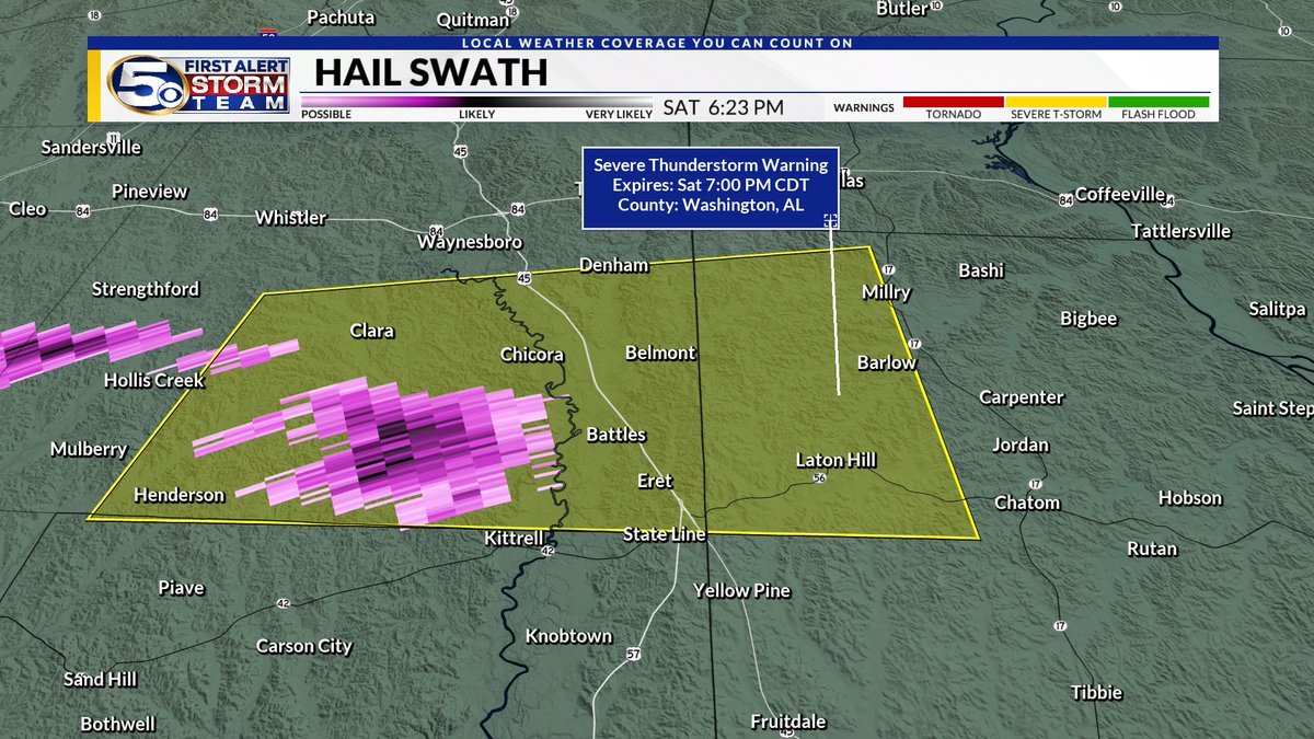
A Severe T-Storm Warning has been issued until 7 p.m. for eastern Wayne county in MS and northwestern Washington county in AL. 60 mph winds and half dollar size hail are possible.

A Severe T-Storm Warning has been issued until 7 p.m. for eastern Wayne county in MS and northwestern Washington county in AL. 60 mph winds and half dollar size hail are possible.
account_circle
WKRG Grant Skinner(@WKRGgrant) 's Twitter Profile Photo

A Severe T-Storm Warning has been issued until 6:30 p.m. for northwestern Escambia, southwestern Conecuh, and southeastern Monroe counties in Alabama. 60 mph wind gusts and half dollar size hail are possible.

A Severe T-Storm Warning has been issued until 6:30 p.m. for northwestern Escambia, southwestern Conecuh, and southeastern Monroe counties in Alabama. 60 mph wind gusts and half dollar size hail are possible.
account_circle
WKRG Grant Skinner(@WKRGgrant) 's Twitter Profile Photo

A Severe T-Storm Warning has been issued until 6 p.m. for northeastern Mobile county. 60 mph wind gusts and half dollar size hail are possible.

A Severe T-Storm Warning has been issued until 6 p.m. for northeastern Mobile county. 60 mph wind gusts and half dollar size hail are possible.
account_circle
WKRG Grant Skinner(@WKRGgrant) 's Twitter Profile Photo

A few storms have developed this afternoon. More scattered rain/storms are possible this evening, but they will mainly stay in our northern counties. More widespread showers are possible into Sun. morning. Gusty winds and small hail are possible. Severe threat is low.

account_circle
WKRG Grant Skinner(@WKRGgrant) 's Twitter Profile Photo

We'll start off mild and muggy with pop-up showers this morning. Chances for scattered showers and storms will increase this afternoon. Full Forecast: tinyurl.com/5dp9smer

We'll start off mild and muggy with pop-up showers this morning. Chances for scattered showers and storms will increase this afternoon. Full Forecast: tinyurl.com/5dp9smer
account_circle
WKRG Grant Skinner(@WKRGgrant) 's Twitter Profile Photo

It has been a beautiful end to this Friday, but a cold front will bring scattered showers and storms this weekend. Fortunately, once the front passes, cooler and drier air will move into place to start next week!

The latest forecast: tinyurl.com/3pjrd349

It has been a beautiful end to this Friday, but a cold front will bring scattered showers and storms this weekend. Fortunately, once the front passes, cooler and drier air will move into place to start next week! The latest forecast: tinyurl.com/3pjrd349
account_circle
WKRG Grant Skinner(@WKRGgrant) 's Twitter Profile Photo

It was another very warm day! We hit 86° in Mobile this afternoon and only dropped to 68° this morning. Tonight will be muggy again ahead of a cold front passing through the area!

It was another very warm day! We hit 86° in Mobile this afternoon and only dropped to 68° this morning. Tonight will be muggy again ahead of a cold front passing through the area!
account_circle
WKRG Grant Skinner(@WKRGgrant) 's Twitter Profile Photo

Happy Friday! After a warm and muggy week, showers and storms return for the weekend. Details below!

MORE: shorturl.at/giR49

Happy Friday! After a warm and muggy week, showers and storms return for the weekend. Details below! MORE: shorturl.at/giR49
account_circle
WKRG Grant Skinner(@WKRGgrant) 's Twitter Profile Photo

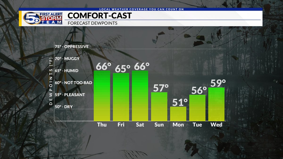
We will end the week on a warm and humid note. Rain chances are still on track to rise this weekend. tinyurl.com/3pjrd349
WKRG

We will end the week on a warm and humid note. Rain chances are still on track to rise this weekend. tinyurl.com/3pjrd349 @WKRG #alwx #mswx #flwx
account_circle
WKRG Grant Skinner(@WKRGgrant) 's Twitter Profile Photo

Starting out with some fog this morning! Once this clears out around mid-morning, those stubborn clouds will stick around. Highs will reach the 80's with just a few sprinkles possible, but changes are coming this weekend. Details below!

MORE: shorturl.at/ikDV3

Starting out with some fog this morning! Once this clears out around mid-morning, those stubborn clouds will stick around. Highs will reach the 80's with just a few sprinkles possible, but changes are coming this weekend. Details below! MORE: shorturl.at/ikDV3
account_circle
WKRG Grant Skinner(@WKRGgrant) 's Twitter Profile Photo

Although the cloud cover will stick around, rain chances will remain quite slim through the rest of the week. A better chance of storms comes this weekend. tinyurl.com/3pjrd349
WKRG

Although the cloud cover will stick around, rain chances will remain quite slim through the rest of the week. A better chance of storms comes this weekend. tinyurl.com/3pjrd349 @WKRG #alwx #mswx #flwx
account_circle
WKRG Grant Skinner(@WKRGgrant) 's Twitter Profile Photo

We are starting out with some patchy fog this morning with mild temps. Highs will top out in the 80's this afternoon with more clouds around and muggy conditions! We cannot rule out a stray shower or two.

MORE: shorturl.at/IJKT3

We are starting out with some patchy fog this morning with mild temps. Highs will top out in the 80's this afternoon with more clouds around and muggy conditions! We cannot rule out a stray shower or two. MORE: shorturl.at/IJKT3
account_circle
WKRG Grant Skinner(@WKRGgrant) 's Twitter Profile Photo

Despite some extra clouds rain chances are looking slim for the the rest of the work week. Our NEXT BIG THING will bring a higher chance of storms this weekend. tinyurl.com/3pjrd349
WKRG

Despite some extra clouds rain chances are looking slim for the the rest of the work week. Our NEXT BIG THING will bring a higher chance of storms this weekend. tinyurl.com/3pjrd349 @WKRG #alwx #mswx #flwx
account_circle