David Tillman (@tillmanweather) 's Twitter Profile
David Tillman

@tillmanweather

Meteorologist at #ABC13, KTRK-TV Houston

ID: 1392425179

linkhttps://www.facebook.com/ABC13DavidTillman calendar_today30-04-2013 16:05:06

5,5K Tweet

15,15K Followers

92 Following

David Tillman (@tillmanweather) 's Twitter Profile Photo

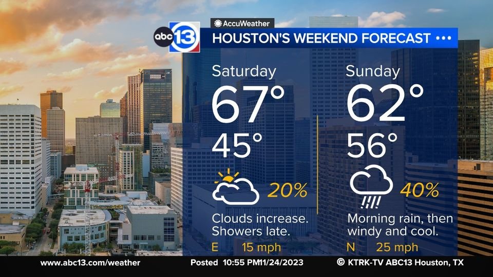
Saturday's weather will be much nicer than Sunday's with mild temps and dry skies until the evening hours. Thunderstorms move in Saturday night ahead of a cold front that pushes through Sunday morning.

Saturday's weather will be much nicer than Sunday's with mild temps and dry skies until the evening hours.  Thunderstorms move in Saturday night ahead of a cold front that pushes through Sunday morning.
Elyse Smith - ABC13 (@abc13elyse) 's Twitter Profile Photo

I don’t know about you, but I’m really excited for this matchup tomorrow! If only the weather was a little better… while we should be drier by kickoff, morning tailgates might be a little damp, drizzly and chilly. ABC13 Houston #WeAreTexans
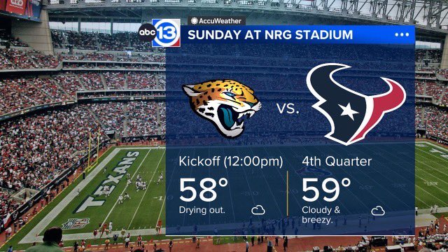
I don’t know about you, but I’m really excited for this matchup tomorrow! If only the weather was a little better… while we should be drier by kickoff, morning tailgates might be a little damp, drizzly and chilly. <a href="/abc13houston/">ABC13 Houston</a> #WeAreTexans
David Tillman (@tillmanweather) 's Twitter Profile Photo

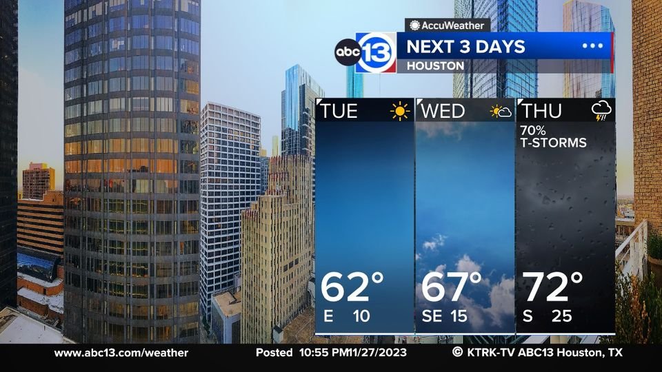
Your Tuesday and Wednesday will feature cold starts and mild afternoon's. It'll be sunny most of that time. Thursday is looking very stormy and severe weather is a possibility. Please keep up with latest forecasts as we approach Thursday.

Your Tuesday and Wednesday will feature cold starts and mild afternoon's.  It'll be sunny most of that time.  Thursday is looking very stormy and severe weather is a possibility.  Please keep up with latest forecasts as we approach Thursday.
David Tillman (@tillmanweather) 's Twitter Profile Photo

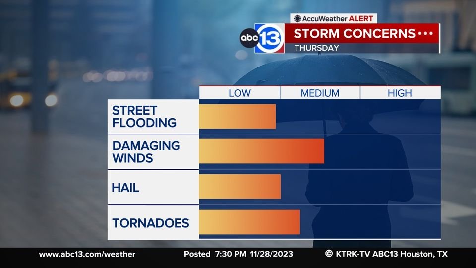
We've designated Thursday an ABC13 Weather Alert Day. Damaging winds and tornadoes will be the main threat with large hail and isolated street flooding a possibility as well. Please keep up with the latest updates as we approach Thursday.

We've designated Thursday an ABC13 Weather Alert Day.  Damaging winds and tornadoes will be the main threat with large hail and isolated street flooding a possibility as well.  Please keep up with the latest updates as we approach Thursday.
David Tillman (@tillmanweather) 's Twitter Profile Photo

Thursday is an ABC13 Weather Alert Day. Severe thunderstorms capable of producing tornadoes, hail, damaging winds, and isolated street flooding will be possible between 9am and 5pm. Please have a way of getting warnings and have a place to take cover if a warning is issued.

Thursday is an ABC13 Weather Alert Day.  Severe thunderstorms capable of producing tornadoes, hail, damaging winds, and isolated street flooding will be possible between 9am and 5pm.  Please have a way of getting warnings and have a place to take cover if a warning is issued.
David Tillman (@tillmanweather) 's Twitter Profile Photo

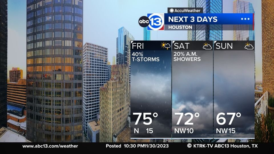
Your 3-Day forecast now includes the weekend. After some scattered storms form Friday afternoon along a cool front, we dry out this weekend. And our temps won't be too warm or cold.

Your 3-Day forecast now includes the weekend.  After some scattered storms form Friday afternoon along a cool front, we dry out this weekend.  And our temps won't be too warm or cold.
David Tillman (@tillmanweather) 's Twitter Profile Photo

Here's your Friday rain chances. Those chances will peak at 40% during the late afternoon hours. Then jump to 90% Friday night. The good news is, there'll be no severe weather, and the rain should be out of here by daybreak on Saturday.

Here's your Friday rain chances.  Those chances will peak at 40% during the late afternoon hours.  Then jump to 90% Friday night.  The good news is, there'll be no severe weather, and the rain should be out of here by daybreak on Saturday.
David Tillman (@tillmanweather) 's Twitter Profile Photo

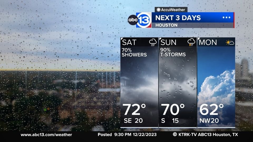
Outside of an isolated shower, your Saturday morning and early afternoon weather should be good enough for shopping. Things change drastically during the late afternoon and evening hours when thunderstorms move in. We raised the rain chance to 90% for Saturday night and Sunday.

Outside of an isolated shower, your Saturday morning and early afternoon weather should be good enough for shopping.  Things change drastically during the late afternoon and evening hours when thunderstorms move in.  We raised the rain chance to 90% for Saturday night and Sunday.
David Tillman (@tillmanweather) 's Twitter Profile Photo

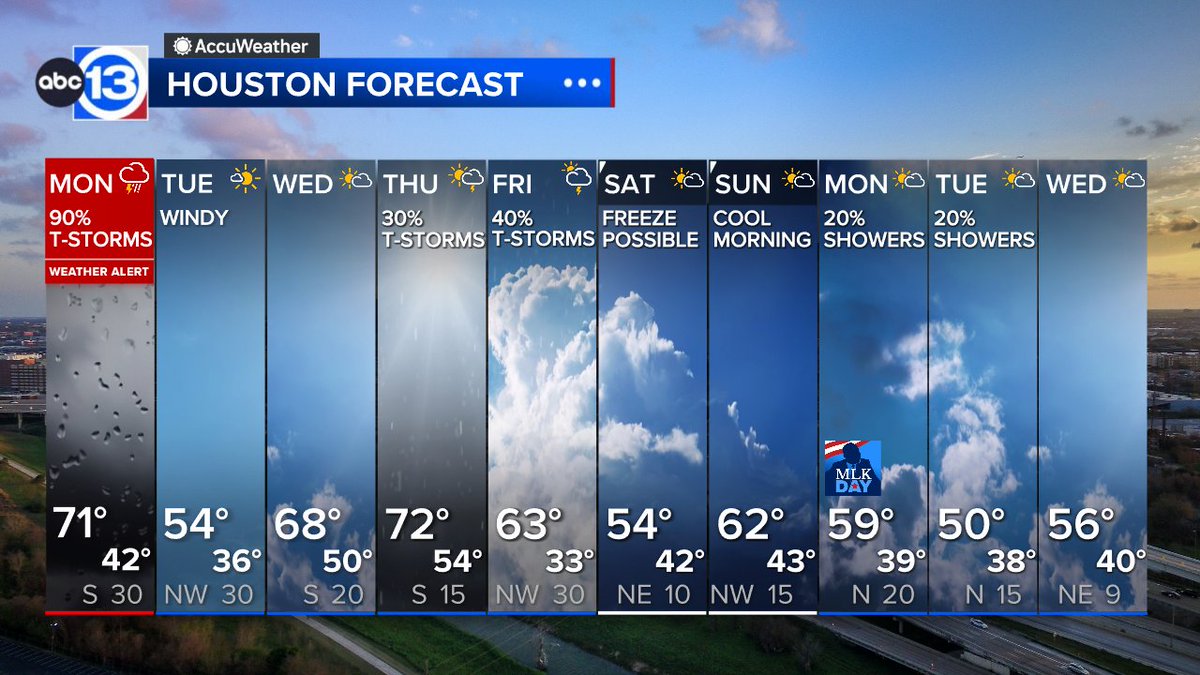
Once we're done with the rain Tuesday night, we have 3 more significant chances over the next 10 days. Keep your umbrella handy!

Once we're done with the rain Tuesday night, we have 3 more significant chances over the next 10 days.  Keep your umbrella handy!
David Tillman (@tillmanweather) 's Twitter Profile Photo

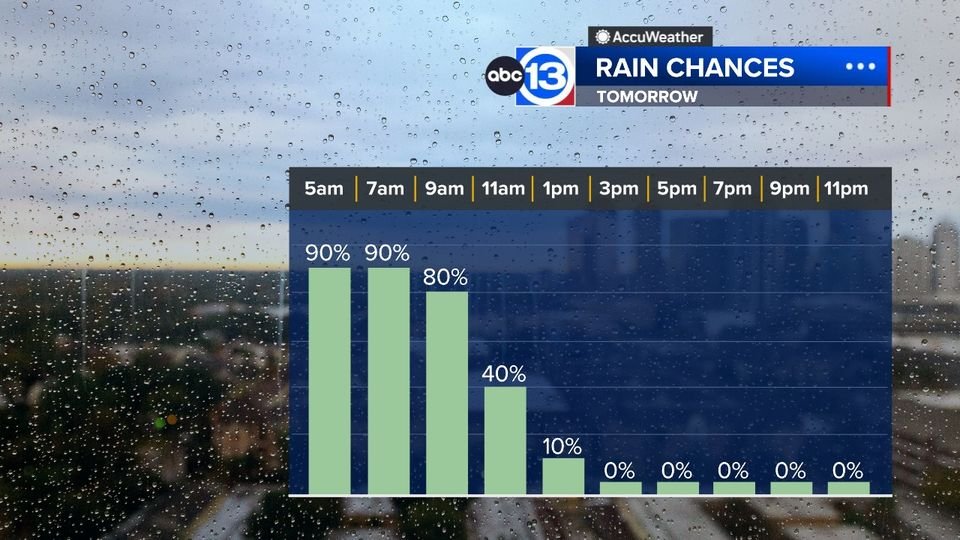
Your Friday morning rush hour is looking very wet. A storm system will move through and give us periods of moderate to heavy rain with claps of thunder, especially between 5am and 9am. Watch out for wet, slick roads with large puddles as you make your way to work or school.

Your Friday morning rush hour is looking very wet.  A storm system will move through and give us periods of moderate to heavy rain with claps of thunder, especially between 5am and 9am.  Watch out for wet, slick roads with large puddles as you make your way to work or school.
Elita Loresca (@abc13elita) 's Twitter Profile Photo

ABC13 Weather Alert Day for the potential for severe t-storms. 2 rounds of these storms forming. #1 this morning, we'll be monitoring the development of supercells capable of producing an isolated strong tornado. #2 arrives along a line of storms. Info: abc13.com/forecast

ABC13 Weather Alert Day for the potential for severe t-storms. 2 rounds of these storms forming. #1 this morning, we'll be monitoring  the development of supercells capable of producing an isolated strong tornado. #2 arrives along a line of storms.

Info: abc13.com/forecast
Elyse Smith - ABC13 (@abc13elyse) 's Twitter Profile Photo

A moment to talk about the heavy rain & flooding. We have reports of swift and high water rescues taking place in our northern counties. Monday you will not want to chance driving through waterlogged roads with how quickly things have escalated tonight. Stay safe! ABC13 Houston
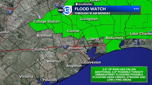
A moment to talk about the heavy rain &amp; flooding. We have reports of swift and high water rescues taking place in our northern counties. Monday you will not want to chance driving through waterlogged roads with how quickly things have escalated tonight. Stay safe! <a href="/abc13houston/">ABC13 Houston</a>
Elita Loresca (@abc13elita) 's Twitter Profile Photo

Heavy downpours and frequent rumbles of thunder have moved into the Bayou City. Be prepared for a messy morning commute. Flooding continues for our northern counties. I'll be monitoring it all for you this morning. LIVE Details: abc13.com/LIVE starting at 4 am

Heavy downpours and frequent rumbles of thunder have moved into the Bayou City. Be prepared for a messy morning commute. Flooding continues for our northern counties. I'll be monitoring it all for you this morning. 

LIVE Details: abc13.com/LIVE starting at 4 am
Elita Loresca (@abc13elita) 's Twitter Profile Photo

Here we go again! Another round of heavy rain & strong/severe storms on the way. A Flood Watch in effect for our northern counties tonight - Thu. night. Rainfall amounts in the watch area: 2-4", isolated amounts between 5-8". Updates: abc13.com/forecast

Here we go again! Another round of heavy rain &amp; strong/severe storms on the way. A Flood Watch in effect for our northern counties tonight - Thu. night. Rainfall amounts in the watch area: 2-4", isolated amounts between 5-8".

Updates: abc13.com/forecast
David Tillman (@tillmanweather) 's Twitter Profile Photo

Thursday is now an ABC13 Weather Alert Day. Flooding rains, especially north of Harris County is the biggest threat but severe winds, large hail, and isolated tornadoes can't be ruled out.

David Tillman (@tillmanweather) 's Twitter Profile Photo

We have two periods of wet weather on the way. Scattered thunderstorms are likely to occur Tuesday and Wednesday of this week. As deep, tropical moisture moves in next week, heavy rain will be possible. Please keep a close eye on the weather as we head into next week.

We have two periods of wet weather on the way.  Scattered thunderstorms are likely to occur Tuesday and Wednesday of this week.  As deep, tropical moisture moves in next week, heavy rain will be possible.  Please keep a close eye on the weather as we head into next week.
David Tillman (@tillmanweather) 's Twitter Profile Photo

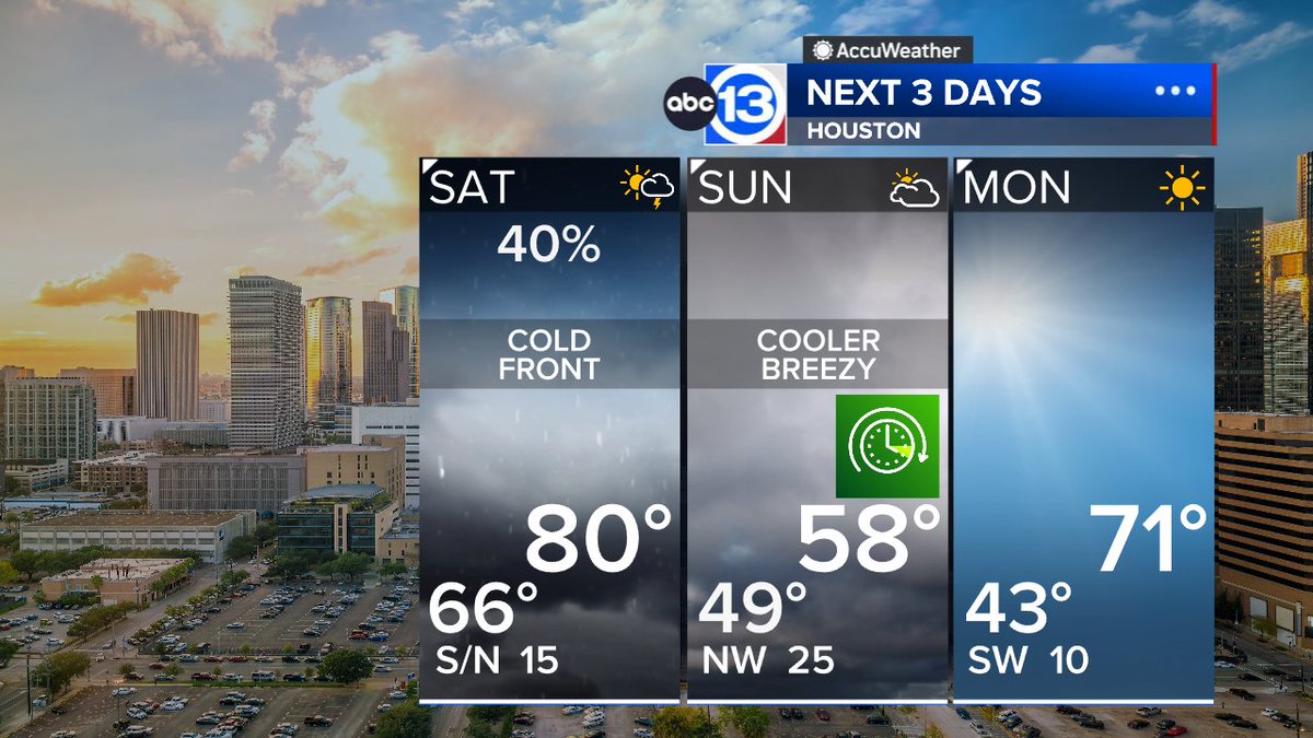
We'll have a few showers and maybe even a thunderstorm around Saturday. The rain will end when a cold front passes during the evening hours. It'll turn windy and cool behind the front, and stay cool and breezy Sunday.

We'll have a few showers and maybe even a thunderstorm around Saturday.  The rain will end when a cold front passes during the evening hours.  It'll turn windy and cool behind the front, and stay cool and breezy Sunday.