Sotiris Valkaniotis(@SotisValkan) 's Twitter Profileg
Sotiris Valkaniotis

@SotisValkan

Consultant Geologist. PostDoc Researcher. Geohazards, Earthquake Geology & Palaeoseismology, Landslides. Remote Sensing Nerd. Military History enthusiast.

ID:438578859

linkhttps://scholar.google.com/citations?user=TxdEgwUAAAAJ&hl=en calendar_today16-12-2011 19:17:25

4,3K Tweets

6,3K Followers

878 Following

国土地理院地理地殻活動研究センター(@GSI_Research) 's Twitter Profile Photo

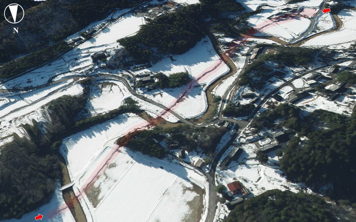
令和6年能登半島地震に伴い、石川県珠洲市若山町に出現した上下変位を伴う線状の地表変状の研究報告を公開しました。
gsi.go.jp/cais/geoinfo-i…

令和6年能登半島地震に伴い、石川県珠洲市若山町に出現した上下変位を伴う線状の地表変状の研究報告を公開しました。 gsi.go.jp/cais/geoinfo-i…
account_circle
Radha Krishna Kavuluru(@iamkrishradha) 's Twitter Profile Photo

HOT UPDATE : ISRO released almost all it's datasets for FREE - for everyone. INDIA now has one of the most progressive & high resolution datasets available for free for it's users.

I just downloaded a dataset from 1990 - 5 YEARS before I was born. What all is free now? 🧵(1/n)

HOT UPDATE : ISRO released almost all it's datasets for FREE - for everyone. INDIA now has one of the most progressive & high resolution datasets available for free for it's users. I just downloaded a dataset from 1990 - 5 YEARS before I was born. What all is free now? 🧵(1/n)
account_circle
Tolga Gorum(@TolgaGorum) 's Twitter Profile Photo

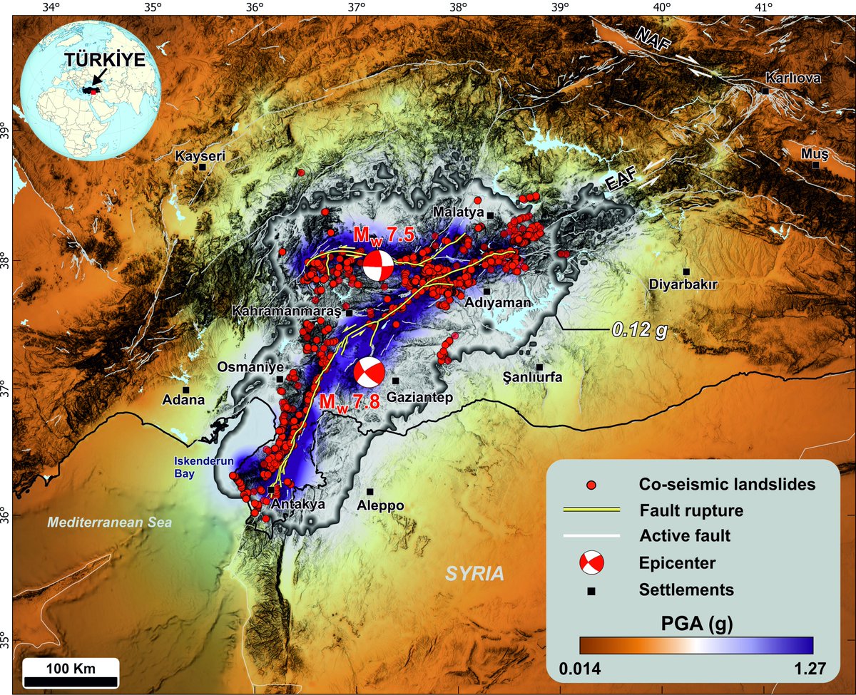
Our article on earthquake-triggered landslides has been published. You can access the article and landslide data by clicking on the link.
sciencedirect.com/science/articl…

Our article on earthquake-triggered landslides has been published. You can access the article and landslide data by clicking on the link. sciencedirect.com/science/articl…
account_circle
Risk and Resilience Assessment Centre DUTh(@riskacduth) 's Twitter Profile Photo

The Geotechnical and Geological hazard team responded immediately to a major landslide that occurred in the mountainous region of Xanthi. Site investigation works included a survey through the use of UAS and the development of a 3D model.

The Geotechnical and Geological hazard team responded immediately to a major landslide that occurred in the mountainous region of Xanthi. Site investigation works included a survey through the use of UAS and the development of a 3D model. #landslide #riskassessment
account_circle
Alba M. Rodríguez Padilla (she/her/ella)(@_absrp) 's Twitter Profile Photo

Pre-print alert! 👋Introducing a probabilistic displacement hazard assessment framework for distributed ruptures from strike-slip earthquakes on immature faults. We are VERY interested in community feedback, Mike Oskin and I are pretty new to PFDHA! eartharxiv.org/repository/vie…

Pre-print alert! 👋Introducing a probabilistic displacement hazard assessment framework for distributed ruptures from strike-slip earthquakes on immature faults. We are VERY interested in community feedback, @mikeoskin and I are pretty new to PFDHA! eartharxiv.org/repository/vie…
account_circle
Seismica(@WeAreSeismica) 's Twitter Profile Photo

Melgar et al. used HR-GNSS and strong motion data to create kinematic rupture models for the Türkiye earthquake doublet. Their results reveal both sub- and super-shear rupture behavior of these events.

Check out doi.org/10.26443/seism… for more details.

account_circle
Patagonian Fossil Turtles 🐢🇦🇷🙋🏻‍♀️🙋🏻‍♂️🇬🇷(@yatachelys) 's Twitter Profile Photo

Μέσα στον πόνο μας που χάσαμε το Βαγιακο μας, βλέπω τι λέτε τώρα πολλοί και πολλές από εσάς στα κανάλια που με φιλοξενήσατε και με βοηθήσατε όσο τον ψάχναμε.

Και ένα έχω να σας πω:
_αγνοουμενοι _Τραγωδια

account_circle
Sotiris Valkaniotis(@SotisValkan) 's Twitter Profile Photo

A preliminary report of liquefaction phenomena triggered by the Feb 6 2023 earthquake in Turkey/Syria can be downloaded via the following link. We mapped 750 sites with liquefaction and lateral spreading using EO zenodo.org/record/7668401 GeorgePapathanassiou

A preliminary report of liquefaction phenomena triggered by the Feb 6 2023 earthquake in Turkey/Syria can be downloaded via the following link. We mapped 750 sites with liquefaction and lateral spreading using EO #earthquake #Turkey #Syria zenodo.org/record/7668401 @gpapatha
account_circle
Prof. Diego Melgar 🌊(@geosmx) 's Twitter Profile Photo

Here's our kinematic model for the Türkiye doublet on a 3D geometry from HR-GNSS and strong motion. Penomenal effort by Prof.Dr. Tuncay Taymaz , Athanassios Ganas, Brendan Crowell and many others. This was a fast and furious multinational work with folks in Türkiye, Greece, and the US (1/n)

account_circle
Sigurjón (Sjonni) Jónsson(@Sjonni_KAUST) 's Twitter Profile Photo

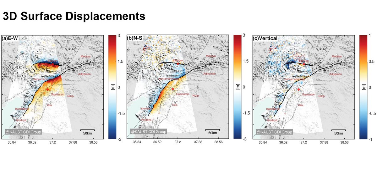
First results of 3D surface displacement derivation for the Turkey earthquake (from Sentinel-1 pixel offsets) showing ~8 m fault offset on the 2nd fault, but limited vertical motions. Processed by @JihongLiu4 at , as part of the CDI and CES_KAUST group efforts

First results of 3D surface displacement derivation for the Turkey earthquake (from Sentinel-1 pixel offsets) showing ~8 m fault offset on the 2nd fault, but limited vertical motions. Processed by @JihongLiu4 at #KAUST, as part of the CDI and @CES_KAUST group efforts
account_circle
Sotiris Valkaniotis(@SotisValkan) 's Twitter Profile Photo

An interesting observation from optical displacement; significant displacement along the NNE-SSW Narli fault, close to the M7.7 epicenter. Displacement mapping shows a previously unmapped ~5km section to the north of Narli F. 🧐twitter.com/SotisValkan/st…

An interesting observation from #Sentinel2 optical displacement; significant displacement along the NNE-SSW Narli fault, close to the M7.7 #earthquake epicenter. Displacement mapping shows a previously unmapped ~5km section to the north of Narli F. 🧐twitter.com/SotisValkan/st…
account_circle
gCent(@gCentBulletin) 's Twitter Profile Photo

M7.8 Turkey (2023.02.06)
M7.5 Turkey (2023.02.06)
earthquake.usgs.gov/earthquakes/ev…

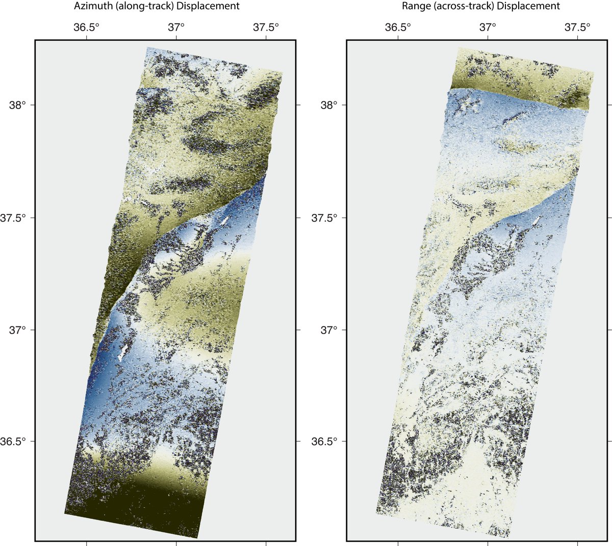
Range and azimuth offsets
ALOS-2 path 78, frame 2850-2890
Imagery courtesy of JAXA and facilitated by NASA

M7.8 Turkey (2023.02.06) M7.5 Turkey (2023.02.06) earthquake.usgs.gov/earthquakes/ev… earthquake.usgs.gov/earthquakes/ev… Range and azimuth offsets ALOS-2 path 78, frame 2850-2890 Imagery courtesy of JAXA and facilitated by NASA
account_circle
Sotiris Valkaniotis(@SotisValkan) 's Twitter Profile Photo

An updated version of fault offset along a ~13km splay section of EAFZ from the Feb 6 M7.7 . Data not clean or accurate but offset follows mapped fault trace. Waiting for raw & new satellite images. post-eq imagery from Maxar Technologies

An updated version of fault offset along a ~13km splay section of EAFZ from the Feb 6 M7.7 #earthquake. Data not clean or accurate but offset follows mapped fault trace. Waiting for raw & new satellite images. post-eq imagery from @Maxar #SatelliteImagery #Turkey #Syria
account_circle
Sotiris Valkaniotis(@SotisValkan) 's Twitter Profile Photo

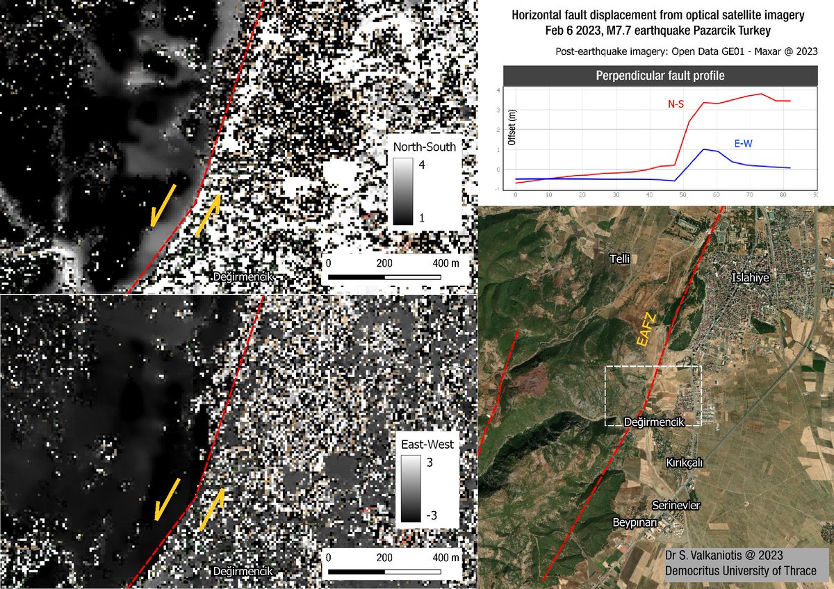
A very crude first look of surface fault offset along the East Anatolian Fault trace from the Feb 6 M7.7 . ~3m of North-South displacement & ~1m of East-West displ. Fast run with post-eq imagery from Maxar Technologies satellite imagery

A very crude first look of surface fault offset along the East Anatolian Fault trace from the Feb 6 M7.7 #earthquake. ~3m of North-South displacement & ~1m of East-West displ. Fast run with post-eq imagery from @Maxar satellite imagery #SatelliteImagery #Earthquake #Turkey #Syria
account_circle