Rhodes Cartography
@rhodesmaps
Maps, mapping, geoviz. No politics.
Fellow @RGS_IBG.
Board member @wmsmapsociety.
Adjunct Professor @georgetownsfs.
@thinkinginspace.bsky.social
ID: 1216100953004351493
http://www.thinkinginspace.net 11-01-2020 20:54:19
1,1K Tweet
6,6K Followers
422 Following


My recent podcast with School of War on Great Power Diplomacy: tinyurl.com/mr3x5dzh. Thanks to Aaron MacLean for an engaging conversation.


*That’s* how you do it. Walking the ground, map in hand. #WWTJ Battle Honours Tours @andyaitcheson


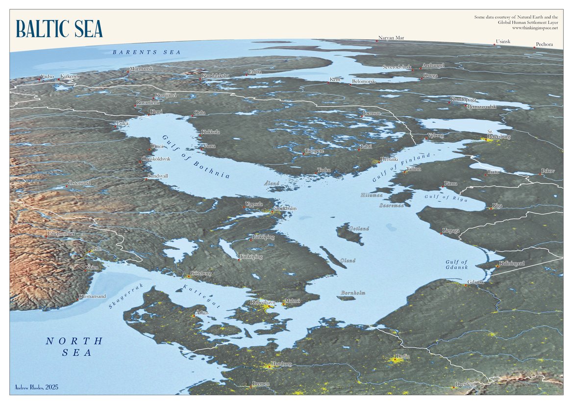
My new map of the Baltic Sea got a strong response last week, especially thanks to the RT by Simon Kuestenmacher. Many seemed to appreciate the fresh perspective on maritime geopolitics, and a few asked for a high-resolution download, so I've posted it here: thinkinginspace.net/f/baltic-sea--…


If you are in London on Nov. 10th, I will be giving a talk at the Royal Geographical Society on 19th century naval history, exploration, and diplomacy in the life of Alexander Macomb Mason. Also online. Information on Royal Geographical Society (with IBG) website: rgs.org/events/upcomin…


I am grateful to Wil Anthony Hay for his thoughtful review of Great Power Diplomacy over the weekend in The Wall Street Journal: wsj.com/arts-culture/b….

So glad to receive my copy of Great Power Diplomacy by Wess Mitchell. It was a worthy challenge to make maps for a range of case studies. I am especially grateful that Wess thought to include a "Note on the Maps": a rare chance to reflect on the interplay of maps and strategy.


Rhodes Cartography I am grateful to Rhodes Cartography for the beautiful, one-of-a-kind maps in Great Power Diplomacy. Strategic cartography of the kind Andrew creates, in the grand tradition of Richard Edes Harrison, has become a lost art in the US.

New Wess Mitchell book (p. 24) "From their perch on the Bosporus, Theodosius and his advisors looked out on a vast estate of dizzying complexity whose frontiers stretched from the Adriatic to the Euphrates and from the Danube to the Nile. In every direction, trouble beckoned."


Rhodes Cartography The kingdom of France had two crucial geopolitical advantages: a big arable northern heartland coursed by deep navigable rivers and imposing natural barriers on every frontier but one.


![LegendesCartographie (@legendescarto) on Twitter photo [ACTUS]
Cette semaine découvrez nos nouvelles cartes, réalisées pour différents projets et à retrouver dès maintenant en librairie.
➡️ Les maîtres du Monde - éditions Eyrolles [ACTUS]
Cette semaine découvrez nos nouvelles cartes, réalisées pour différents projets et à retrouver dès maintenant en librairie.
➡️ Les maîtres du Monde - éditions Eyrolles](https://pbs.twimg.com/media/G3mt85-WoAA63b2.jpg)