NWS Milwaukee (@nwsmilwaukee) 's Twitter Profile
NWS Milwaukee

@nwsmilwaukee

Official Twitter account for the National Weather Service in Milwaukee. Details: weather.gov/twitter

ID: 601715758

linkhttp://weather.gov/milwaukee calendar_today07-06-2012 09:20:10

29,29K Tweet

36,36K Followers

396 Following

NWS Milwaukee (@nwsmilwaukee) 's Twitter Profile Photo

Earlier day showers and thundershowers are pushing east late this afternoon. A cold front is moving through the area, and could help trigger widely scattered showers and thundershowers through 8:00 PM. Severe weather is not expected in any redevelopment.

Earlier day showers and thundershowers are pushing east late this afternoon. A cold front is moving through the area, and could help trigger widely scattered showers and thundershowers through 8:00 PM. Severe weather is not expected in any redevelopment.
NWS Milwaukee (@nwsmilwaukee) 's Twitter Profile Photo

Cooler, Fall-like temperatures will prevail through the end of the work week and first day of the weekend. Scattered showers are expected during the afternoon hours on Friday. Mostly sunny skies prevail through the weekend, with a gradual warming trend expected by Sunday. #wiwx

Cooler, Fall-like temperatures will prevail through the end of the work week and first day of the weekend. Scattered showers are expected during the afternoon hours on Friday. Mostly sunny skies prevail through the weekend, with a gradual warming trend expected by Sunday. #wiwx
NWS Milwaukee (@nwsmilwaukee) 's Twitter Profile Photo

Life threatening waves and currents are expected at Lake Michigan beaches in southeast WI through Saturday afternoon. Stay out of the water and away from dangerous areas like piers and break walls. #swiwx #wiwx

Life threatening waves and currents are expected at Lake Michigan beaches in southeast WI through Saturday afternoon. Stay out of the water and away from dangerous areas like piers and break walls. #swiwx #wiwx
NWS Milwaukee (@nwsmilwaukee) 's Twitter Profile Photo

Scattered showers linger early this evening. They will move south southeast with a brief period of rain before ending. An isolated lightning strike may occur with a storm. A few waterspouts are possible as showers move out over Lake Michigan tonight into Sat. #swiwx #wiwx

Scattered showers linger early this evening. They will move south southeast with a brief period of rain before ending. An isolated lightning strike may occur with a storm. A few waterspouts are possible as showers move out over Lake Michigan tonight into Sat. #swiwx #wiwx
NWS Milwaukee (@nwsmilwaukee) 's Twitter Profile Photo

Cool temperatures are expected into Saturday night, before a warming trend takes hold for next week. Dry conditions are expected this weekend into next week as well. #swiwx #wiwx

Cool temperatures are expected into Saturday night, before a warming trend takes hold for next week. Dry conditions are expected this weekend into next week as well. #swiwx #wiwx
NWS Milwaukee (@nwsmilwaukee) 's Twitter Profile Photo

Life threatening waves and currents are expected at Lake Michigan beaches in southeast WI through this afternoon. Stay out of the water and away from dangerous areas like piers and break walls. #swiwx #wiwx

Life threatening waves and currents are expected at Lake Michigan beaches in southeast WI through this afternoon. Stay out of the water and away from dangerous areas like piers and break walls. #swiwx #wiwx
NWS Milwaukee (@nwsmilwaukee) 's Twitter Profile Photo

Cool temperatures are expected into tonight, before a warming trend takes hold for next week. Dry conditions are expected this weekend into next week as well. #swiwx #wiwx

Cool temperatures are expected into tonight, before a warming trend takes hold for next week. Dry conditions are expected this weekend into next week as well. #swiwx #wiwx
ReadyWisconsin (@readywisconsin) 's Twitter Profile Photo

No power? No problem! An NOAA Weather Radio is always there to warn you about severe weather before it happens. Learn about different alerts so there are no surprises: ow.ly/zbI550Threv #ReadyWI #NPM2024

No power? No problem!

An NOAA Weather Radio is always there to warn you about severe weather before it happens.

Learn about different alerts so there are no surprises: ow.ly/zbI550Threv

#ReadyWI #NPM2024
NWS Milwaukee (@nwsmilwaukee) 's Twitter Profile Photo

A warm and dry week is in store for S WI with high temps in the 70s today then 80s the rest of the week. The warmth will likely continue into mid to late Sept. and possibly longer. #swiwx

A warm and dry week is in store for S WI with high temps in the 70s today then 80s the rest of the week. The warmth will likely continue into mid to late Sept. and possibly longer. #swiwx
NWS Milwaukee (@nwsmilwaukee) 's Twitter Profile Photo

A warmup is expected for this week. Summer-like high temperatures in the 80s will become established by mid-week. Canadian wildfire smoke will lead to hazy conditions tonight and tomorrow.

A warmup is expected for this week. Summer-like high temperatures in the 80s will become established by mid-week. Canadian wildfire smoke will lead to hazy conditions tonight and tomorrow.
NWS Milwaukee (@nwsmilwaukee) 's Twitter Profile Photo

Summer-like temps with low relative humidity will prevail this week. Canadian wildfire smoke will lead to hazy conditions today and possibly on Tuesday. #swiwx

Summer-like temps with low relative humidity will prevail this week. Canadian wildfire smoke will lead to hazy conditions today and possibly on Tuesday. #swiwx
NWS Milwaukee (@nwsmilwaukee) 's Twitter Profile Photo

Above normal temperatures are expected through the remainder of the work week, with highs mainly in the 80s. Skies will be mostly sunny to partly cloudy through Friday, with another round of smoky skies aloft possible on Wednesday. #wiwx

Above normal temperatures are expected through the remainder of the work week, with highs mainly in the 80s. Skies will be mostly sunny to partly cloudy through Friday, with another round of smoky skies aloft possible on Wednesday. #wiwx
NWS Milwaukee (@nwsmilwaukee) 's Twitter Profile Photo

Warm and dry conditions will continue this week. Wildfire smoke from out west, and partly cloudy skies will prevail over S WI during this time. The smoke is expected to remain in the upper atmosphere. #swiwx

Warm and dry conditions will continue this week. Wildfire smoke from out west, and partly cloudy skies will prevail over S WI during this time. The smoke is expected to remain in the upper atmosphere.   #swiwx
NWS Milwaukee (@nwsmilwaukee) 's Twitter Profile Photo

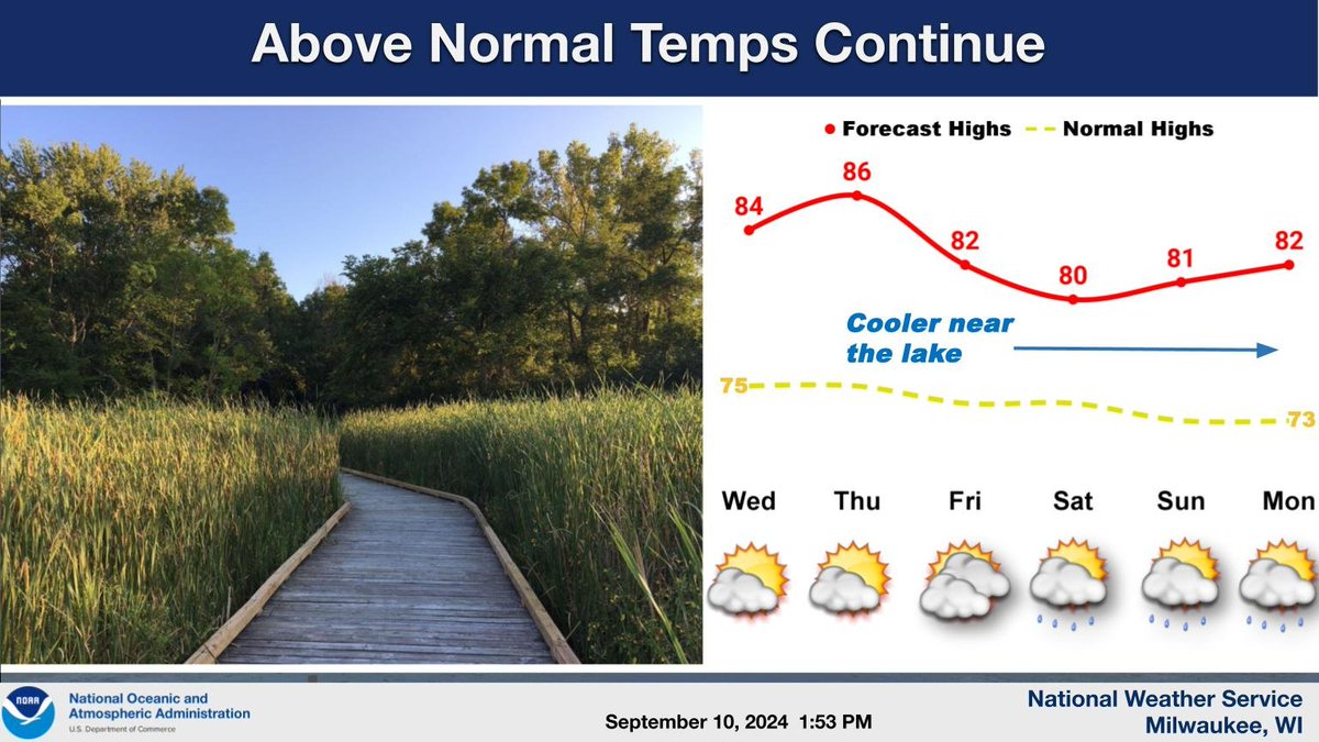
Temperatures will remain above normal through the end of this week and into early next week. Dry weather will persist through Friday, with a small chance for showers and maybe a rumble of thunder Saturday through Monday. #wiwx

Temperatures will remain above normal through the end of this week and into early next week. Dry weather will persist through Friday, with a small chance for showers and maybe a rumble of thunder Saturday through Monday. #wiwx
NWS Milwaukee (@nwsmilwaukee) 's Twitter Profile Photo

2024 Wisconsin Tornado Count Update: Now 45. NWS Twin Cities updated some information regarding the 8/29 tornadoes in west central WI which included extending the path of a MN tornado to SE of Prescott and raising the Beldenville TOR up to an EF-1. #wiwx weather.gov/mkx/wisconsint…

2024 Wisconsin Tornado Count Update: Now 45.  <a href="/NWSTwinCities/">NWS Twin Cities</a> updated some information regarding the 8/29 tornadoes in west central WI which included extending the path of a MN tornado to SE of Prescott and raising the Beldenville TOR up to an EF-1.  #wiwx weather.gov/mkx/wisconsint…