NWS Northern Indiana (@nwsiwx) 's Twitter Profile
NWS Northern Indiana

@nwsiwx

Official Twitter account for the National Weather Service Northern Indiana. Details: weather.gov/twitter

ID: 596680300

linkhttp://weather.gov/iwx calendar_today01-06-2012 18:12:18

40,40K Tweet

28,28K Takipçi

241 Takip Edilen

NWS Northern Indiana (@nwsiwx) 's Twitter Profile Photo

Canadian wildfire smoke continues to move into the Great Lakes region. As smoke particles mix down to the surface, air quality is expected to become unhealthy into the day tomorrow, especially for sensitive groups. Check the current air quality here: fire.airnow.gov

NWS Northern Indiana (@nwsiwx) 's Twitter Profile Photo

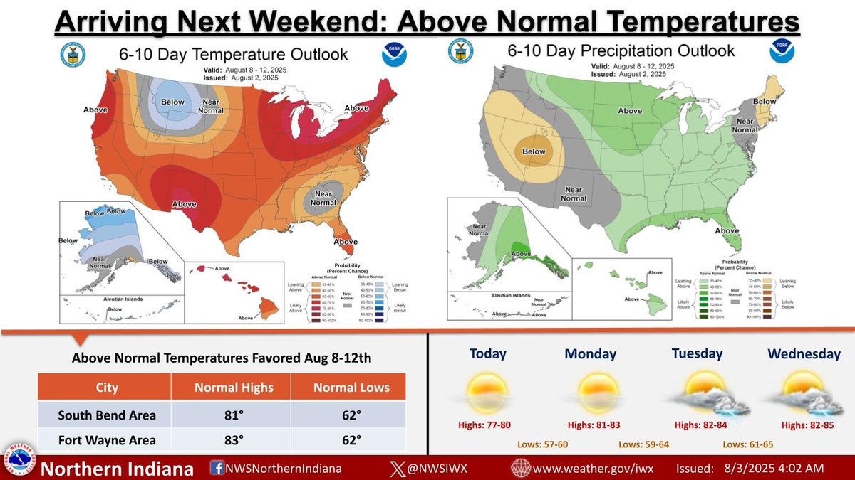
Pleasant weekend weather continues with high creeping closer to 80 this afternoon. The Climate Prediction Center favors above-normal temperatures by next weekend into early next week. There is a slight lean toward above-normal rainfall as well. #inwx #ohwx #miwx

Pleasant weekend weather continues with high creeping closer to 80 this afternoon.  The Climate Prediction Center favors above-normal temperatures by next weekend into early next week. There is a slight lean toward above-normal rainfall as well. #inwx #ohwx #miwx
NWS Northern Indiana (@nwsiwx) 's Twitter Profile Photo

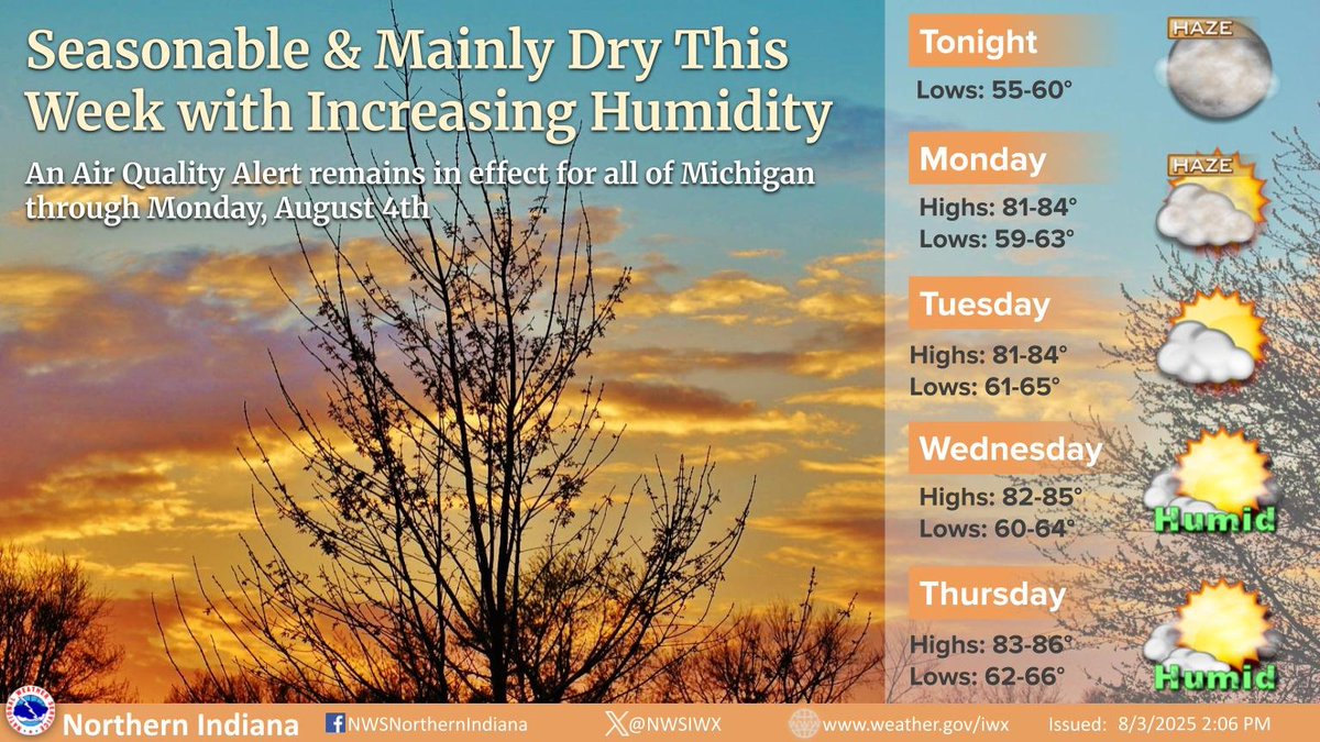
An Air Quality Alert remains in effect through Monday for all of Michigan due to Canadian wildfire smoke. Seasonable temperatures this week with mainly dry conditions (aside from a 20% chance for rain/storms on Tuesday/Wednesday). Humidity increases by midweek. #INwx #MIwx #OHwx

An Air Quality Alert remains in effect through Monday for all of Michigan due to Canadian wildfire smoke. Seasonable temperatures this week with mainly dry conditions (aside from a 20% chance for rain/storms on Tuesday/Wednesday). Humidity increases by midweek. #INwx #MIwx #OHwx
NWS Northern Indiana (@nwsiwx) 's Twitter Profile Photo

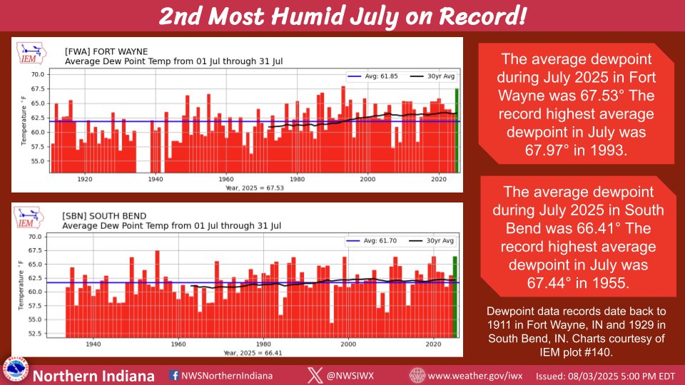
July 2025 ranks as the 2nd most humid July on record for Fort Wayne, IN and South Bend, IN! 🌽🥵🔥 The average dewpoint in Fort Wayne was 67.53°, making it the most humid July since 1993. In South Bend, the average dewpoint was 66.41°, which is the most humid July since 2020.

July 2025 ranks as the 2nd most humid July on record for Fort Wayne, IN and South Bend, IN! 🌽🥵🔥 The average dewpoint in Fort Wayne was 67.53°, making it the most humid July since 1993. In South Bend, the average dewpoint was 66.41°, which is the most humid July since 2020.
NWS Northern Indiana (@nwsiwx) 's Twitter Profile Photo

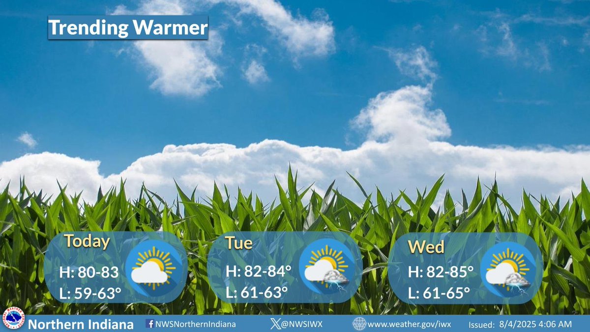
High temperatures will continue to warm in the coming days. There could be a couple, isolated thunderstorms around Tuesday and Wednesday afternoon. Full forecast: weather.gov/iwx #inwx #ohwx #miwx

High temperatures will continue to warm in the coming days. There could be a couple, isolated thunderstorms around Tuesday and Wednesday afternoon. Full forecast: weather.gov/iwx 
#inwx #ohwx #miwx
NWS Northern Indiana (@nwsiwx) 's Twitter Profile Photo

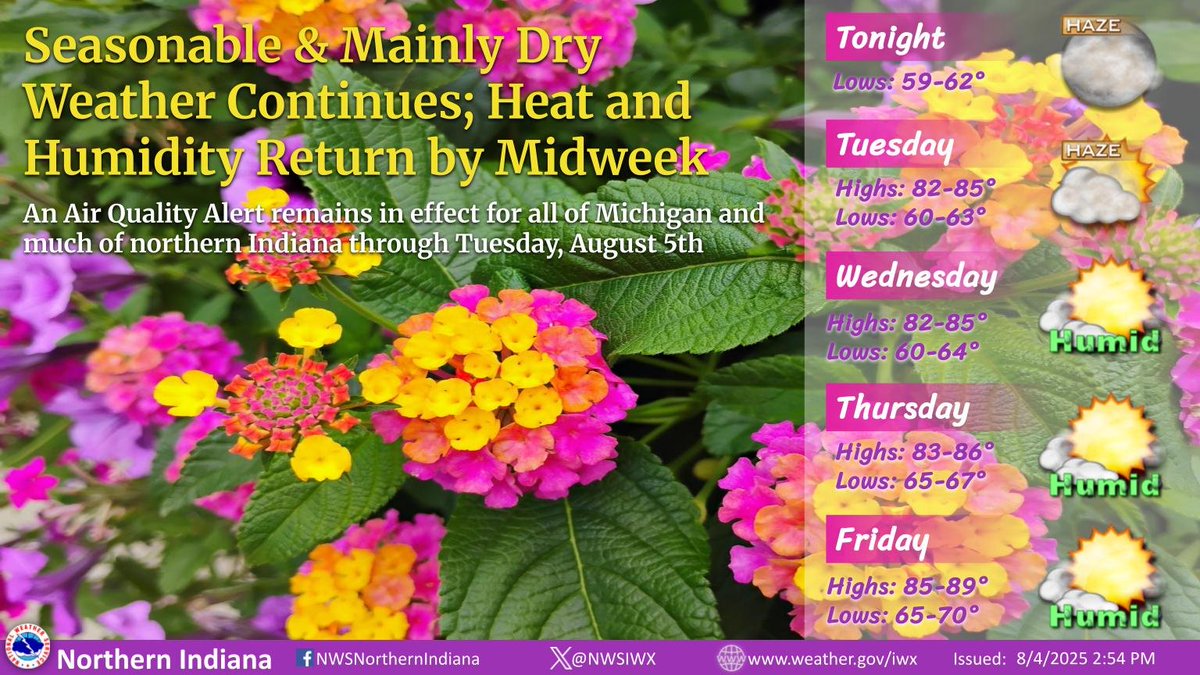
An Air Quality Alert remains in effect through Tuesday for all of Michigan and much of northern Indiana due to Canadian wildfire smoke. Seasonable temperatures continue with mainly dry conditions (20% chances for rain/storms on Tuesday/Wednesday) and increasing humidity midweek.

An Air Quality Alert remains in effect through Tuesday for all of Michigan and much of northern Indiana due to Canadian wildfire smoke. Seasonable temperatures continue with mainly dry conditions (20% chances for rain/storms on Tuesday/Wednesday) and increasing humidity midweek.
National Weather Service (@nws) 's Twitter Profile Photo

Introducing a new series, NOAAstalgia: Picturing Our Past. Every other week, The NOAA Heritage Program will be sharing photos from NOAA's history. In this week's photo, a young woman launches a pilot weather balloon. Women's first professional opportunities in meteorology

Introducing a new series, NOAAstalgia: Picturing Our Past. Every other week, The NOAA Heritage Program will be sharing photos from NOAA's history.

In this week's photo, a young woman launches a pilot weather balloon. Women's first professional opportunities in meteorology
NWS Northern Indiana (@nwsiwx) 's Twitter Profile Photo

Hot and humid weather returns late this week and into mid August. The newest 6-10 Day Temperature Outlook from NWS Climate Prediction Center shows high probabilities of above normal temperatures for the Northeast and Great Lakes regions, as well as much of the western CONUS.
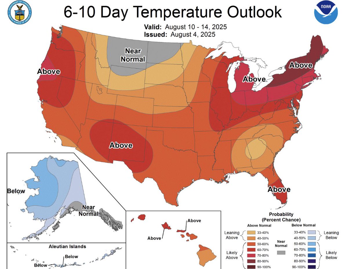
Hot and humid weather returns late this week and into mid August. The newest 6-10 Day Temperature Outlook from <a href="/NWSCPC/">NWS Climate Prediction Center</a> shows high probabilities of above normal temperatures for the Northeast and Great Lakes regions, as well as much of the western CONUS.
NWS Northern Indiana (@nwsiwx) 's Twitter Profile Photo

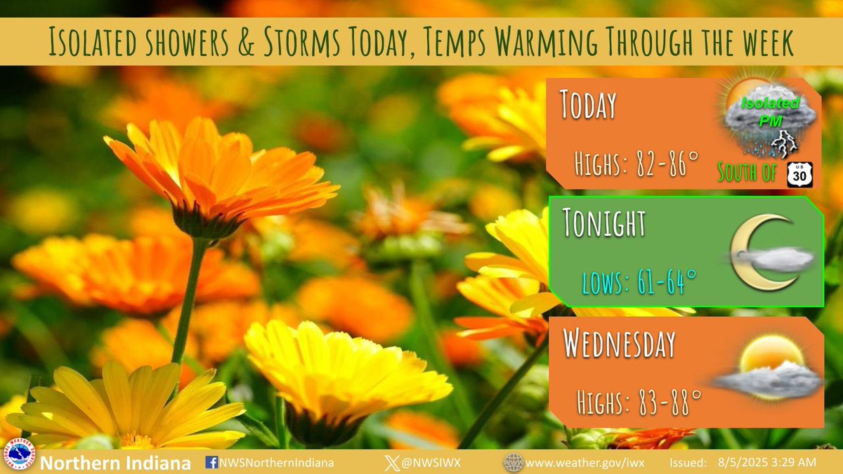
Dry conditions through Wed outside of an isolated shower or storm this afternoon, mainly south of US 30. Temperatures will warm through the work week, with highs in the mid-upper 80s. Lows tonight will be in the low-mid 60s.

Dry conditions through Wed outside of an isolated shower or storm this afternoon, mainly south of US 30. Temperatures will warm through the work week, with highs in the mid-upper 80s.  Lows tonight will be in the low-mid 60s.
NWS Northern Indiana (@nwsiwx) 's Twitter Profile Photo

The NWS is working with National Integrated Heat Health Information System to raise awareness about extreme heat. Every Tuesday during the month of August, we will share information and heat safety tips relating to a specific topic. Today's topic is staying cool outside during extreme heat! #HeatSafety #CoolDownTuesday

The NWS is working with <a href="/HeatGov/">National Integrated Heat Health Information System</a> to raise awareness about extreme heat. Every Tuesday during the month of August, we will share information and heat safety tips relating to a specific topic. Today's topic is staying cool outside during extreme heat! #HeatSafety #CoolDownTuesday
NWS Northern Indiana (@nwsiwx) 's Twitter Profile Photo

Staying cool during extreme heat is important! During a heat wave, practice heat safety wherever you are. Heat related deaths and illnesses are preventable! #CoolDownTuesday #NIHHIS #HeatSafety National Integrated Heat Health Information System

Staying cool during extreme heat is important! During a heat wave, practice heat safety wherever you are. Heat related deaths and illnesses are preventable! #CoolDownTuesday #NIHHIS #HeatSafety <a href="/HeatGov/">National Integrated Heat Health Information System</a>
NWS Northern Indiana (@nwsiwx) 's Twitter Profile Photo

Warm temperatures can quickly rise to dangerous levels - especially in the summer and in parked cars. Stay #WeatherReady and don’t underestimate the heat! #CoolDownTuesday #NIHHIS #HeatSafety National Integrated Heat Health Information System
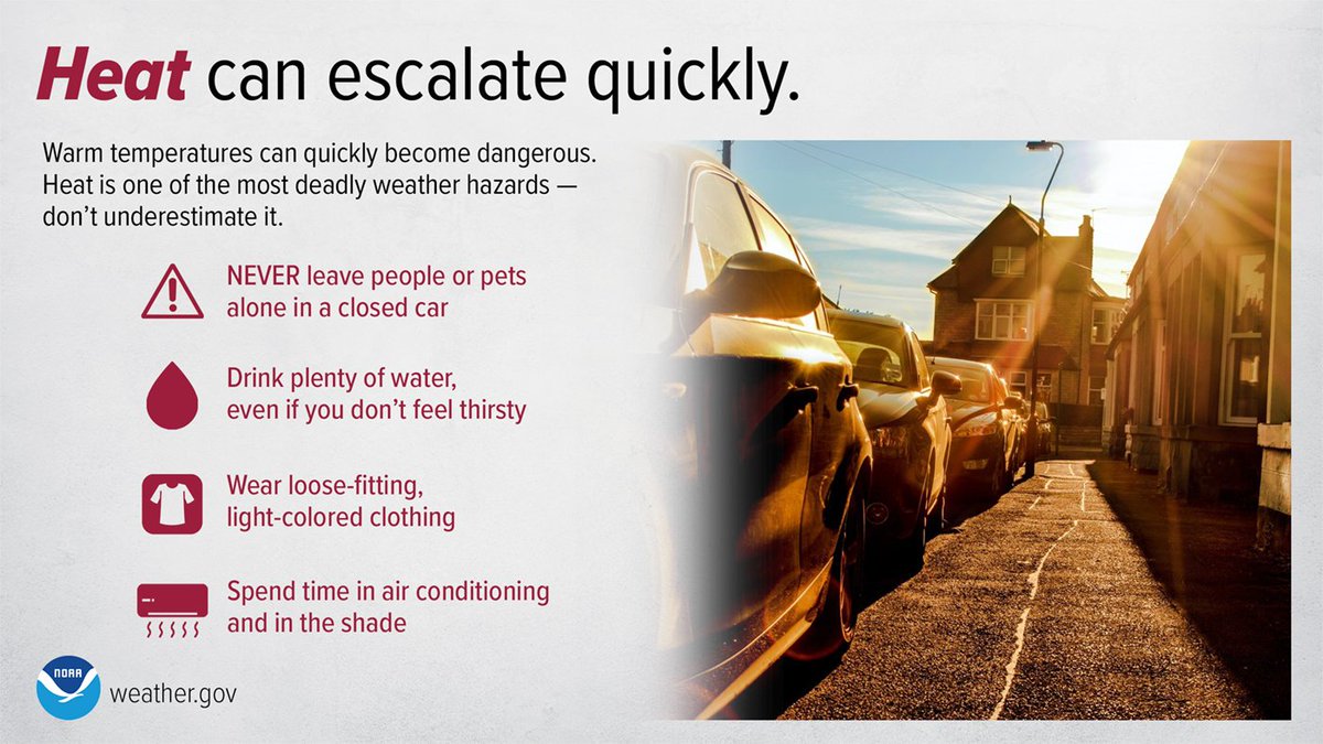
Warm temperatures can quickly rise to dangerous levels - especially in the summer and in parked cars. Stay #WeatherReady and don’t underestimate the heat! #CoolDownTuesday #NIHHIS #HeatSafety <a href="/HeatGov/">National Integrated Heat Health Information System</a>
NWS Northern Indiana (@nwsiwx) 's Twitter Profile Photo

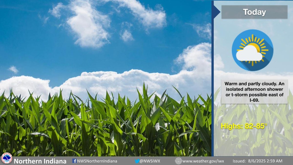
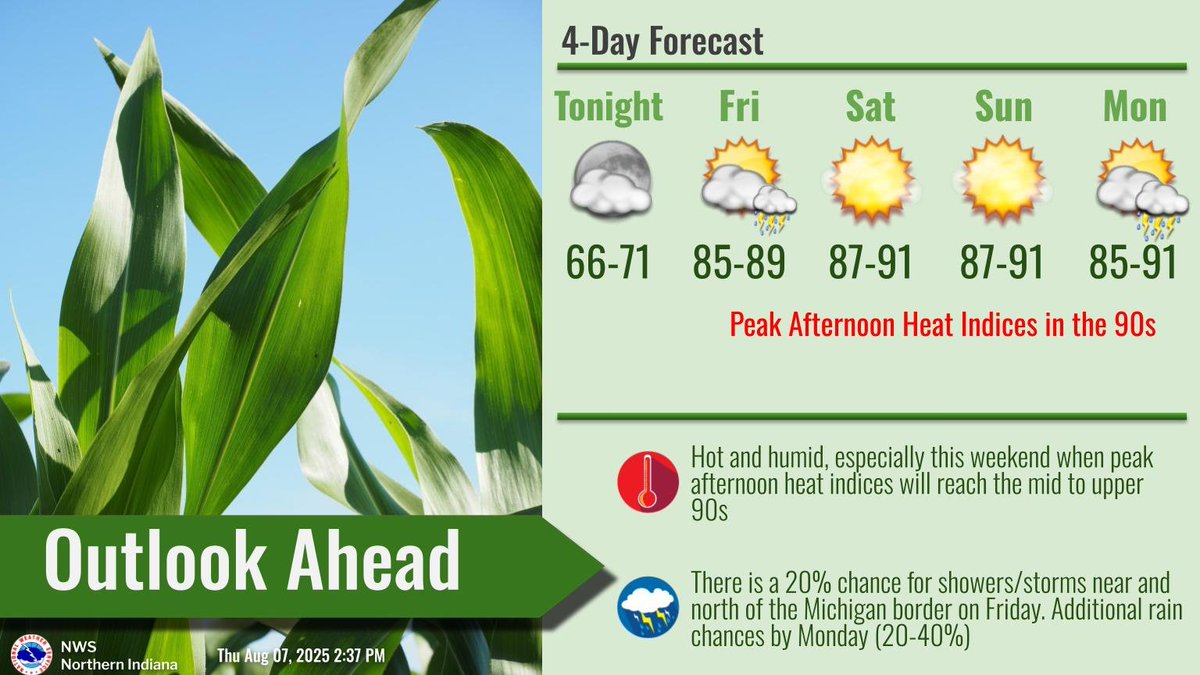
An isolated shower or storm is possible this evening south of US Route 24. An isolated thunderstorm is also possible Wednesday afternoon across northwest Ohio. Heat and humidity slowly build through the week. Peak afternoon heat indices by Thursday may reach around 90.

An isolated shower or storm is possible this evening south of US Route 24.  An isolated thunderstorm is also possible Wednesday afternoon across northwest Ohio.  Heat and humidity slowly build through the week.  Peak afternoon heat indices by Thursday may reach around 90.
NWS Northern Indiana (@nwsiwx) 's Twitter Profile Photo

Stay safe in the heat! Limit outdoor activities. Drink plenty of water and avoid alcohol. Wear light-colored clothing and sunscreen. Work outdoors early or very late in the day. #CoolDownTuesday #NIHHIS #HeatSafety National Integrated Heat Health Information System

Stay safe in the heat! Limit outdoor activities. Drink plenty of water and avoid alcohol. Wear light-colored clothing and sunscreen. Work outdoors early or very late in the day.  #CoolDownTuesday #NIHHIS #HeatSafety <a href="/HeatGov/">National Integrated Heat Health Information System</a>
NWS Northern Indiana (@nwsiwx) 's Twitter Profile Photo

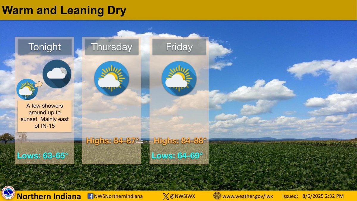
Some showers and maybe an isolated thunderstorm will be around this afternoon before dissipating around sunset. Dry weather remains, though, through the end of the week with slightly above normal temperatures and some humidity around.

Some showers and maybe an isolated thunderstorm will be around this afternoon before dissipating around sunset. Dry weather remains, though, through the end of the week with slightly above normal temperatures and some humidity around.
NWS Northern Indiana (@nwsiwx) 's Twitter Profile Photo

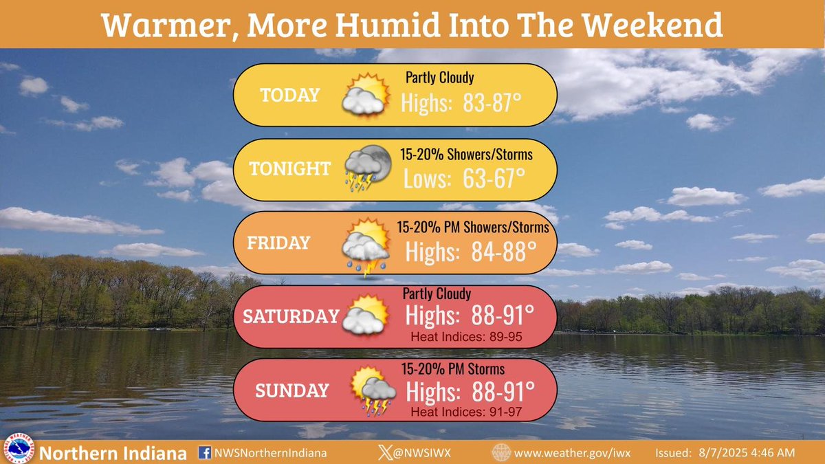
Getting warmer and more humid into the weekend. Dry weather expected for a majority of the area over the next several days. A few slight chances for showers/t-storms tonight, Friday afternoon, and again Sunday afternoon. #INwx #MIwx #OHwx

Getting warmer and more humid into the weekend. Dry weather expected for a majority of the area over the next several days. A few slight chances for showers/t-storms tonight, Friday afternoon, and again Sunday afternoon. #INwx #MIwx #OHwx
NWS Northern Indiana (@nwsiwx) 's Twitter Profile Photo

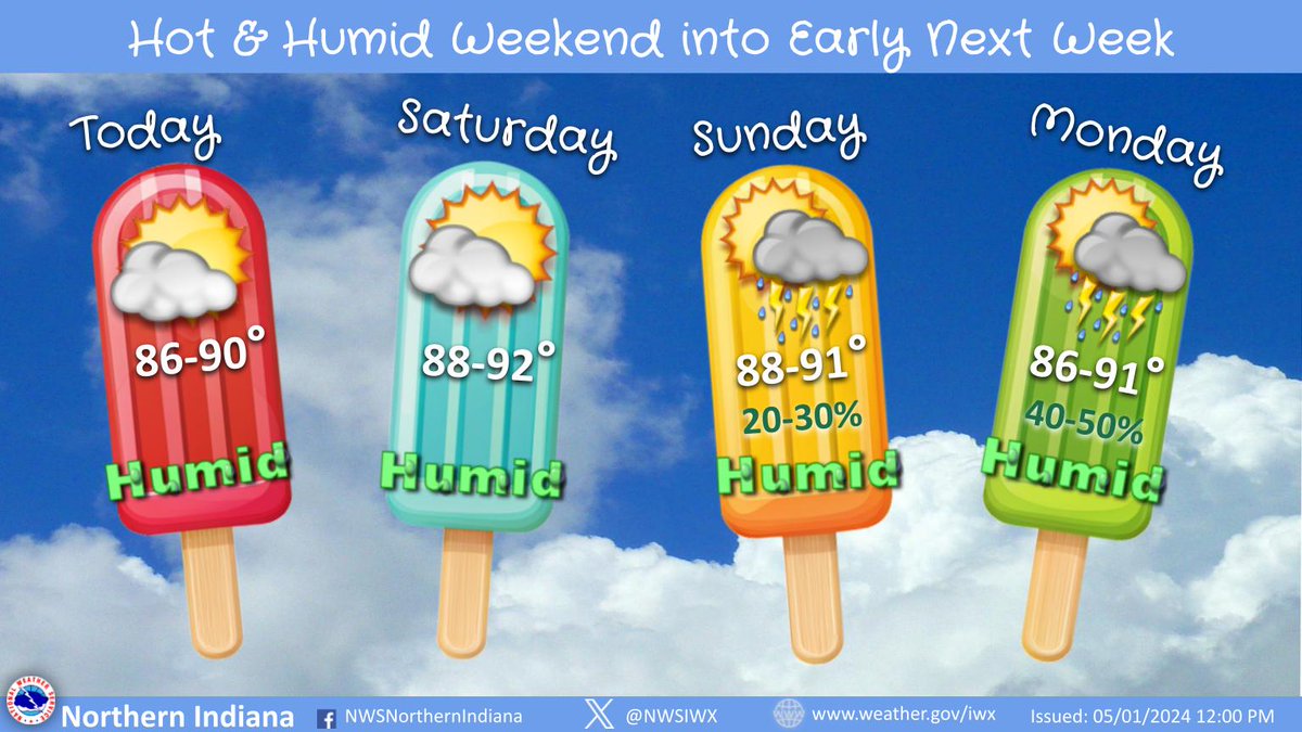
A hot and humid August weekend is ahead with peak heat indices in the mid 90s. The first half of the weekend will be dry before chances for scattered rain/storms return Sunday and Monday. Stay hydrated and don't forget sunscreen if you're planning to spend time outdoors!

A hot and humid August weekend is ahead with peak heat indices in the mid 90s. The first half of the weekend will be dry before chances for scattered rain/storms return Sunday and Monday. Stay hydrated and don't forget sunscreen if you're planning to spend time outdoors!
NWS Northern Indiana (@nwsiwx) 's Twitter Profile Photo

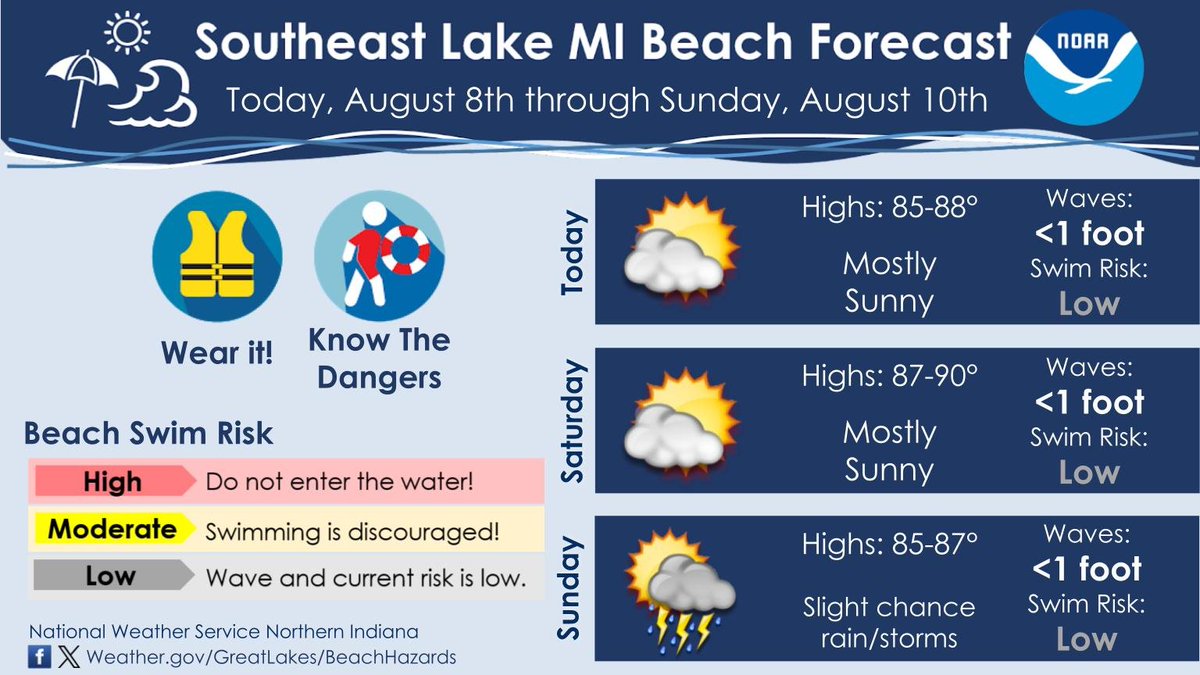
Heading to the beaches of southeast Lake Michigan today or over the weekend? Good news! The swim risk will be low over the next few days! Always use caution in and around the water, especially as there could still be currents or steep drop offs you can't clearly see.

Heading to the beaches of southeast Lake Michigan today or over the weekend? Good news! The swim risk will be low over the next few days! Always use caution in and around the water, especially as there could still be currents or steep drop offs you can't clearly see.