NASAEarthdata (@nasaearthdata) 's Twitter Profile
NASAEarthdata

@nasaearthdata

Discover NASA Earth science data, information, services and tools. Have questions? [email protected] Verification: nasa.gov/socialmedia

ID: 2282667775

linkhttps://earthdata.nasa.gov calendar_today08-01-2014 21:58:39

6,6K Tweet

40,40K Takipçi

399 Takip Edilen

NASAEarthdata (@nasaearthdata) 's Twitter Profile Photo

New data release! 🛰️ April 2025 global surface air temp & precipitation data is available. Learn more about this monthly assessment of anomalies and extremes: earthdata.nasa.gov/data/alerts-ou… #EarthData #precipitation #NASA

New data release!
🛰️ April 2025 global surface air temp & precipitation data is available.
Learn more about this monthly assessment of anomalies and extremes: earthdata.nasa.gov/data/alerts-ou…
#EarthData #precipitation #NASA
NASA Earth (@nasaearth) 's Twitter Profile Photo

Severe storms unleashed hail, wind and tornadoes across the U.S. Midwest and Mid-Atlantic on May 16, 2025. Satellites revealed some of the damage in the wake of the storms, like this #Landsat view of a tornado track in southern Illinois. go.nasa.gov/4dvDmdh

Severe storms unleashed hail, wind and tornadoes across the U.S. Midwest and Mid-Atlantic on May 16, 2025. Satellites revealed some of the damage in the wake of the storms, like this #Landsat view of a tornado track in southern Illinois. go.nasa.gov/4dvDmdh
NASAEarthdata (@nasaearthdata) 's Twitter Profile Photo

Some ECOsystem Spaceborne Thermal Radiometer Experiment on Space Station (ECOSTRESS) data products will no longer be available through the Earthdata Search beginning May 30, 2025. Learn more: earthdata.nasa.gov/data/alerts-ou…

NASAEarthdata (@nasaearthdata) 's Twitter Profile Photo

New Data Release 🛰️ The OPERA Project Level 3 displacement product is now available. It provides actionable land surface change data while making satellite radar data more accessible to a broad range of users. Read more about the release at earthdata.nasa.gov/news/opera-pro… #NASAdata #SAR

New Data Release 🛰️
The OPERA Project Level 3 displacement product is now available. It provides actionable land surface change data while making satellite radar data more accessible to a broad range of users.
Read more about the release at earthdata.nasa.gov/news/opera-pro…
#NASAdata #SAR
NASAEarthdata (@nasaearthdata) 's Twitter Profile Photo

🌎 Worldview Image of the Week 📸 This week's image, captured by the VIIRS instrument aboard the Suomi NPP platform, shows starkly different chlorophyll a concentrations within the Great Salt Lake. Read more and view an interactive image at earthdata.nasa.gov/news/worldview…

🌎 Worldview Image of the Week 📸
This week's image, captured by the VIIRS instrument aboard the Suomi NPP platform, shows starkly different chlorophyll a concentrations within the Great Salt Lake.
Read more and view an interactive image at earthdata.nasa.gov/news/worldview…
NASA Landsat (@nasa_landsat) 's Twitter Profile Photo

Did you know there are 190 confirmed impact craters on Earth? #Landsat 8 captured an image of the Goyder impact structure in Australia—discovered in the 1990s—overlaid on a digital elevation model to give a sense of the topography. 🛰️ go.nasa.gov/3H6oPbP

Did you know there are 190 confirmed impact craters on Earth? 

#Landsat 8 captured an image of the Goyder impact structure in Australia—discovered in the 1990s—overlaid on a digital elevation model to give a sense of the topography. 🛰️

go.nasa.gov/3H6oPbP
NASA Earth (@nasaearth) 's Twitter Profile Photo

Ready for a puzzler? 🧩 Tell us the location of this satellite image and why it is interesting. We’ll share the answer at 1pm ET. Hint: find the blue glow!

Ready for a puzzler? 🧩
Tell us the location of this satellite image and why it is interesting. We’ll share the answer at 1pm ET. 

Hint: find the blue glow!
NASAEarthdata (@nasaearthdata) 's Twitter Profile Photo

On Rachel Carson Day, we honor a legacy of environmental awareness and science-driven action. Dive into how NASA continues that work by tracking the health of rivers and streams from space. earthdata.nasa.gov/topics/terrest… #RachelCarsonDay #EarthScience #Environment

NASAEarthdata (@nasaearthdata) 's Twitter Profile Photo

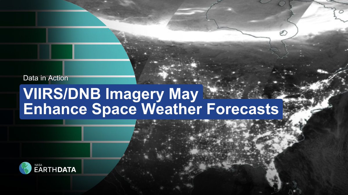
In a new Data-in-Action story, learn how VIIRS Day/Night Band imagery was used to differentiate between nighttime lights signals and light contamination from aurorae and how these products may enhance space weather forecasts. Read more: go.nasa.gov/3Z764eD

In a new Data-in-Action story, learn how VIIRS Day/Night Band imagery was used to differentiate between nighttime lights signals and light contamination from aurorae and how these products may enhance space weather forecasts. 
Read more: go.nasa.gov/3Z764eD
NASAEarthdata (@nasaearthdata) 's Twitter Profile Photo

More commercial datasets are now available through NASA’s SNWG Earthdata Search Portal! Access high-resolution imagery and radar data to support environmental monitoring, disaster response, and more. Learn more here: earthdata.nasa.gov/news/additiona…

More commercial datasets are now available through NASA’s SNWG Earthdata Search Portal!
Access high-resolution imagery and radar data to support environmental monitoring, disaster response, and more.

Learn more here: earthdata.nasa.gov/news/additiona…
NASAEarthdata (@nasaearthdata) 's Twitter Profile Photo

🌊Need near real-time flood data? The VIIRS Flood Product provides global flood insights and will support continuity as the MODIS instruments reach end of life. Learn more and access the data at earthdata.nasa.gov/news/blog/moni… #EarthScience #FloodData #VIIRS

🌊Need near real-time flood data?
The VIIRS Flood Product provides global flood insights and will support continuity as the MODIS instruments reach end of life.
Learn more and access the data at earthdata.nasa.gov/news/blog/moni…
#EarthScience #FloodData #VIIRS
NASAEarthdata (@nasaearthdata) 's Twitter Profile Photo

Learn more about BlackSky's high-resolution and very-high-resolution electro-optical imagery available through NASA's Commercial Satellite Data Acquisition Program in the latest NASA CSDA program Vendor Focus webinar: go.nasa.gov/3ZitRZ6

Learn more about BlackSky's high-resolution and very-high-resolution electro-optical imagery available through NASA's Commercial Satellite Data Acquisition Program in the latest NASA CSDA program Vendor Focus webinar: go.nasa.gov/3ZitRZ6
NASAEarthdata (@nasaearthdata) 's Twitter Profile Photo

The "Discover and Access the OPERA-DISP Dataset Using ASF DAAC’s Displacement Portal" data training webinar is now available online. Learn more about NASA’s JPL OPERA InSAR-derived surface displacement measurements product. go.nasa.gov/4kuU7YA #SAR

The "Discover and Access the OPERA-DISP Dataset Using ASF DAAC’s Displacement Portal" data training webinar is now available online. Learn more about NASA’s JPL OPERA InSAR-derived surface displacement measurements product.  go.nasa.gov/4kuU7YA
#SAR
NASAEarthdata (@nasaearthdata) 's Twitter Profile Photo

NASA offers many tools to help you access and get the most out of NASA Earth observation data. But which tool is the right one for you and your objectives? This chart is designed to help you identify the correct tool for the data you need: earthdata.nasa.gov/data/tools/whi…

NASA offers many tools to help you access and get the most out of NASA Earth observation data. But which tool is the right one for you and your objectives? This chart is designed to help you identify the correct tool for the data you need: earthdata.nasa.gov/data/tools/whi…
NASAEarthdata (@nasaearthdata) 's Twitter Profile Photo

Important announcement: NASA is consolidating its 400+ social media accounts as part of an agency-wide effort to streamline communication. As a result, this account will become inactive. Stay tuned for additional information. Learn more about NASA's social media consolidation: