Kirk 🇺🇸 Hinz | BAM ⚡️Weather (@met_khinz) 's Twitter Profile
Kirk 🇺🇸 Hinz | BAM ⚡️Weather

@met_khinz

Relationship Executive & Senior Meteorologist: @BAMwxcom + @clarity_wx | 📧 [email protected] | Phil 4:13

ID: 270313622

linkhttp://bamwx.com calendar_today22-03-2011 11:41:51

66,66K Tweet

10,10K Followers

886 Following

BAM Weather (@bam_weather) 's Twitter Profile Photo

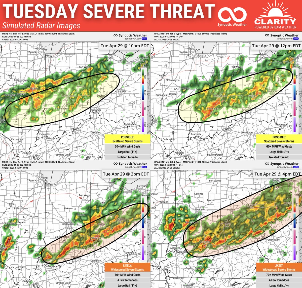
SEVERE WEATHER THREAT UPDATE: Timing has sped up with storms moving along the I-70 corridor tomorrow morning. Damaging winds, large hail and an isolated tornado possible. A more intense wind and higher tornado threat will shift south in the afternoon. Full forecast video

SEVERE WEATHER THREAT UPDATE:
Timing has sped up with storms moving along the I-70 corridor tomorrow morning. Damaging winds, large hail and an isolated tornado possible.

A more intense wind and higher tornado threat will shift south in the afternoon. Full forecast video
Kirk 🇺🇸 Hinz | BAM ⚡️Weather (@met_khinz) 's Twitter Profile Photo

Be sure to tune into the live at BAM Weather, but you can stay ahead of the forecast with our Clarity platform! Sign up for the Home (personal) subscription, today! bamwx.com/claritypackages

BAM Weather (@bam_weather) 's Twitter Profile Photo

"How's the weather shaping ahead for #plant25 progress?" "Will there be a #drought this summer?" "What years are we tracking weather closest to right now?" We answer all these & more in our multi-day commodity ag weather updates. DM / email me at [email protected] for more

"How's the weather shaping ahead for #plant25 progress?"

"Will there be a #drought this summer?"

"What years are we tracking weather closest to right now?"

We answer all these & more in our multi-day commodity ag weather updates. DM / email me at Kirk@bamwx.com for more
Kirk 🇺🇸 Hinz | BAM ⚡️Weather (@met_khinz) 's Twitter Profile Photo

From our team at BAM Weather If you looked at the forecast earlier this week, you probably expected a warm and sunny weekend. However, a cut-off upper-level low is now expected to stall over the Ohio Valley, disrupting those plans with cooler temperatures and periods of rain
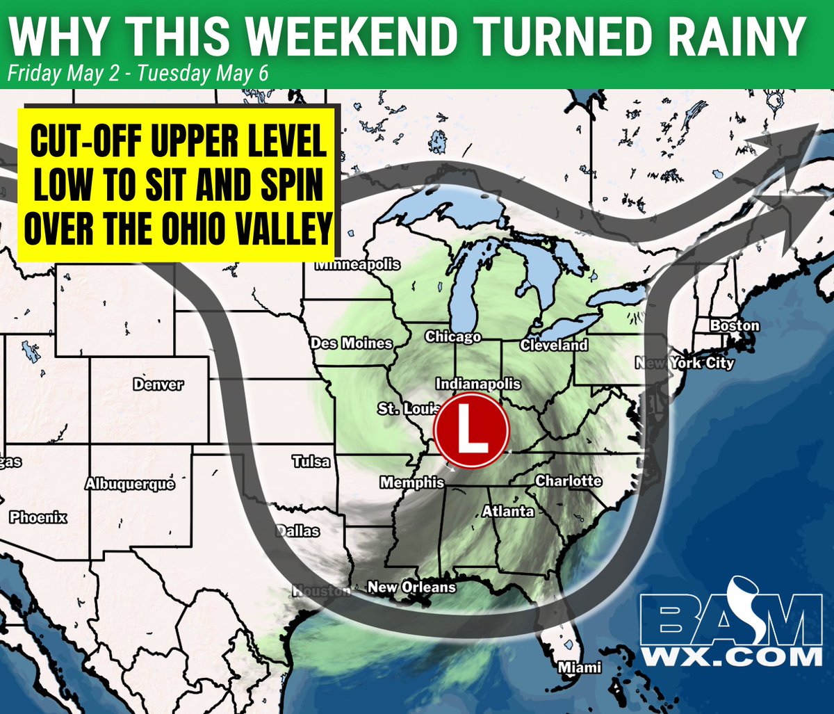
From our team at <a href="/bam_weather/">BAM Weather</a> 

If you looked at the forecast earlier this week, you probably expected a warm and sunny weekend. However, a cut-off upper-level low is now expected to stall over the Ohio Valley, disrupting those plans with cooler temperatures and periods of rain
BAM Weather (@bam_weather) 's Twitter Profile Photo

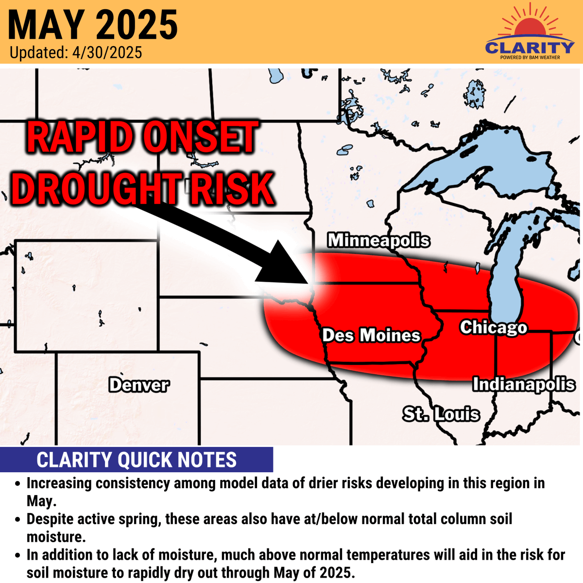
Much above normal temperatures + dryness the next 10 days + below normal soil moisture already = conditions are ripe to rapidly dry out. We highlighted an area we were most concerned about this last week and data picking up on it well. We'll go into full details in our

Much above normal temperatures + dryness the next 10 days + below normal soil moisture already = conditions are ripe to rapidly dry out. 

We highlighted an area we were most concerned about this last week and data picking up on it well. 

We'll go into full details in our
BAM Weather (@bam_weather) 's Twitter Profile Photo

Drier conditions building into the Ag Belt--perfect for planting... BUT will it become too dry? The latest details in our Long Range video on YouTube! youtube.com/watch?v=rlY3Oi… #agwx #plant25

BAM Weather (@bam_weather) 's Twitter Profile Photo

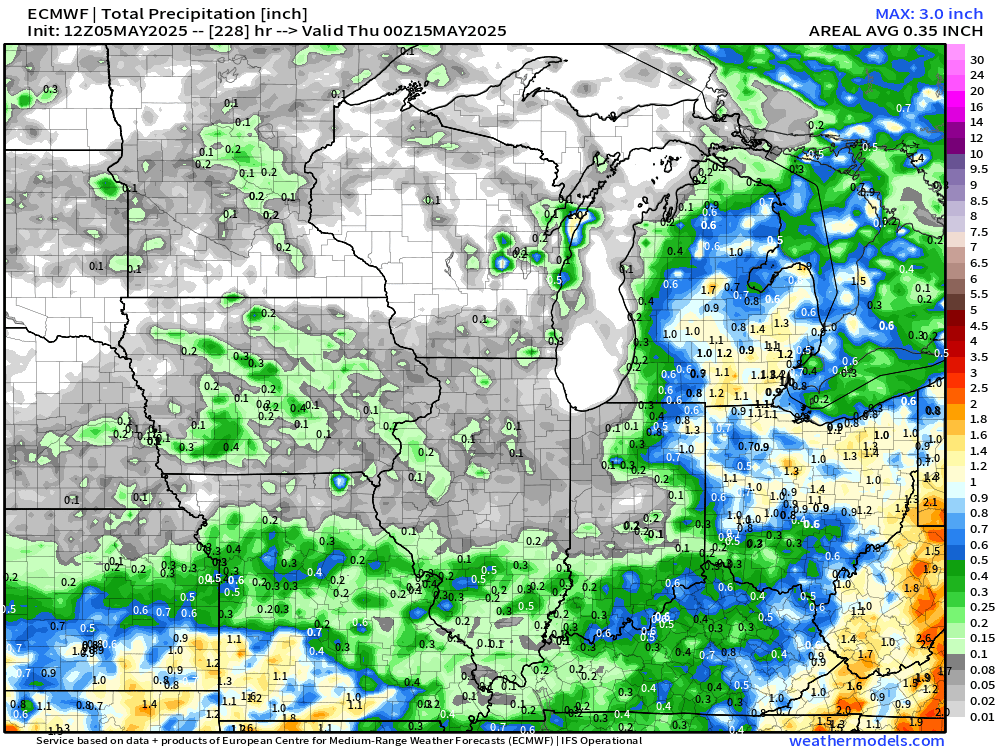
Mid-day data continues to indicate little moisture opportunities the next ~10-11 days across the Corn Belt. *Fantastic* planting conditions ahead, but the question is, will the rains turn back on late May? Some signals in there for the potential but questions remain about how

Mid-day data continues to indicate little moisture opportunities the next ~10-11 days across the Corn Belt. 

*Fantastic* planting conditions ahead, but the question is, will the rains turn back on late May? Some signals in there for the potential but questions remain about how
BAM Weather (@bam_weather) 's Twitter Profile Photo

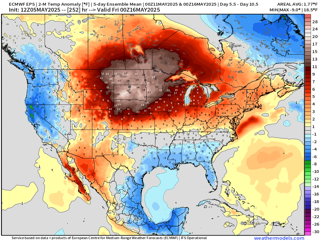
No doubt about it - soil moisture will start evaporating quick with temperatures 10 - 15F+ above normal this time of the year. Things may "feel" quite a bit different 10 days from now.

No doubt about it - soil moisture will start evaporating quick with temperatures 10 - 15F+ above normal this time of the year. Things may "feel" quite a bit different 10 days from now.
Kirk 🇺🇸 Hinz | BAM ⚡️Weather (@met_khinz) 's Twitter Profile Photo

From our team at BAM Weather We continue to eye Friday for potential more WIDESPREAD #severeweather risks across the Ohio Valley with Thursday's threat being more scattered/isolated in the Ohio Valley. The latest storm progression analysis below ⚠
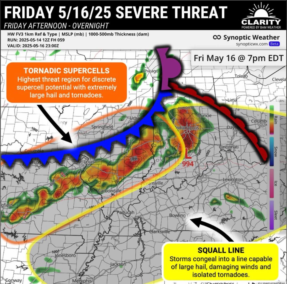
From our team at <a href="/bam_weather/">BAM Weather</a>

We continue to eye Friday for potential more WIDESPREAD #severeweather risks across the Ohio Valley with Thursday's threat being more scattered/isolated in the Ohio Valley.

The latest storm progression analysis below ⚠
Kirk 🇺🇸 Hinz | BAM ⚡️Weather (@met_khinz) 's Twitter Profile Photo

From our team BAM Weather 🚨SEVERE WEATHER UPDATE (5/16/25): Widespread, significant severe weather is likely across S. Indiana, N. Kentucky and S Illinois this afternoon. General timing will be 4PM - 11PM from west to east. Timing for Indy Metro likely 7 - 9PM timeframe.
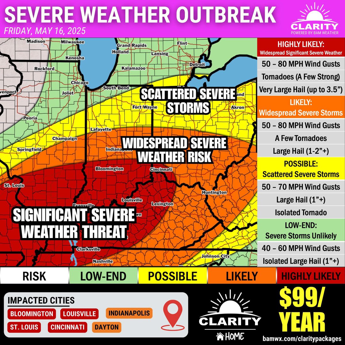
From our team <a href="/bam_weather/">BAM Weather</a> 

🚨SEVERE WEATHER UPDATE (5/16/25): 

Widespread, significant severe weather is likely across S. Indiana, N. Kentucky and S Illinois this afternoon. General timing will be 4PM - 11PM from west to east. Timing for Indy Metro likely 7 - 9PM timeframe.
Ralph Reiff (@ralphreiff2) 's Twitter Profile Photo

I’ve evaluated, discussed, and visited weather industry companies. BAM Weather is my choice. Realtime chat with a meteorologist adds an expert to your team. High Performance… it all matters.

I’ve evaluated, discussed, and visited weather industry companies.  <a href="/bam_weather/">BAM Weather</a> is my choice.  Realtime chat with a meteorologist adds an expert to your team.  High Performance… it all matters.
BAM Weather (@bam_weather) 's Twitter Profile Photo

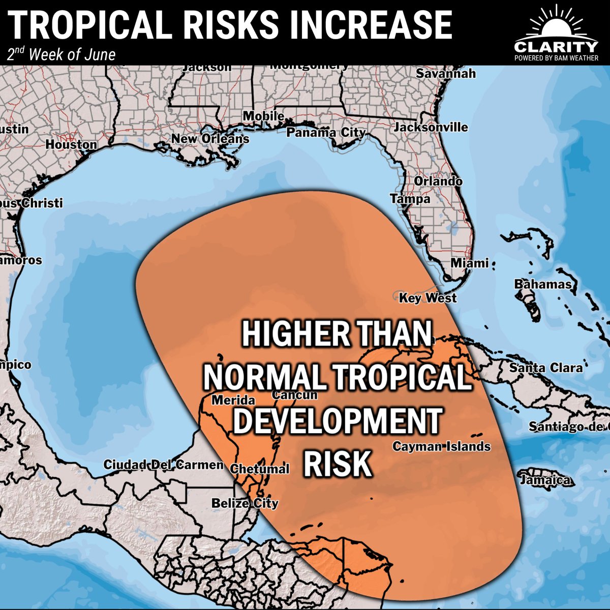
We need to monitor the second week of June for increasing tropical development risks in the Caribbean and Gulf. Favorable tropical forcing would indicate an increased risk and model data is beginning to hint at the idea as well.

We need to monitor the second week of June for increasing tropical development risks in the Caribbean and Gulf.

Favorable tropical forcing would indicate an increased risk and model data is beginning to hint at the idea as well.
BAM Weather (@bam_weather) 's Twitter Profile Photo

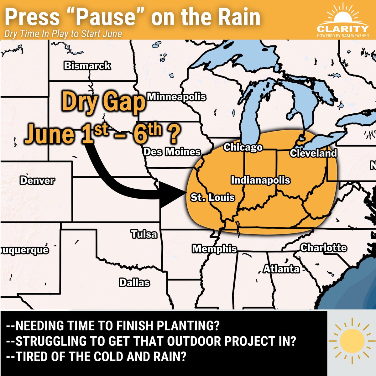
Some lingering, isolated showers can't be ruled out, but in general we are cautiously optimistic in regards to a gap in the active pattern 😁. Don't worry, we all muttered "we'll believe it when we see it" today as well when looking at models 🤣🤣 but seriously guys it looks good

Some lingering, isolated showers can't be ruled out, but in general we are cautiously optimistic in regards to a gap in the active pattern 😁. Don't worry, we all muttered "we'll believe it when we see it" today as well when looking at models 🤣🤣 but seriously guys it looks good
BAM Weather (@bam_weather) 's Twitter Profile Photo

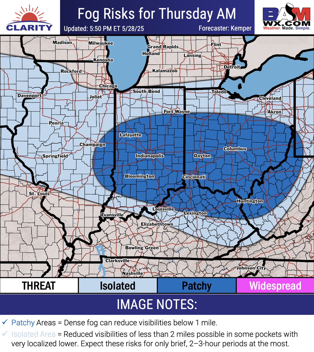
Be on ALERT 🚨 Patchy fog is in the forecast for many of us throughout the Ohio Valley tomorrow morning. Reduced visibilities off less than 1 mile will be likely for those located in the "Patchy" zone. Early morning patchy fog raises hazardous concerns for the morning commute.

Be on ALERT 🚨

Patchy fog is in the forecast for many of us throughout the Ohio Valley tomorrow morning. Reduced visibilities off less than 1 mile will be likely for those located in the "Patchy" zone.

Early morning patchy fog raises hazardous concerns for the morning commute.
BAM Weather (@bam_weather) 's Twitter Profile Photo

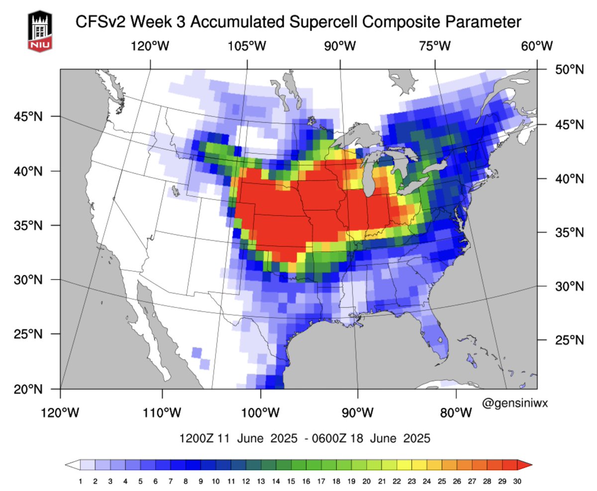
We're not done with severe weather yet..in-fact June could be one of the most active severe weather Junes we have witnessed in decades. The week 2 and week 3 forecasts are very aggressive for conducive environments for severe weather outbreaks. June overall is looking like a

We're not done with severe weather yet..in-fact June could be one of the most active severe weather Junes we have witnessed in decades. 

The week 2 and week 3 forecasts are very aggressive for conducive environments for severe weather outbreaks. 

June overall is looking like a
BAM Weather (@bam_weather) 's Twitter Profile Photo

Today, Michael Clark and Bret Walts unpack a common misconception: Weather hardware isn’t always the solution—and it might actually be costing you more. 🔗 YouTube: youtube.com/watch?v=HBasU9… 🔗Spotify: open.spotify.com/episode/6r4JNr… 🔗Apple Podcasts: podcasts.apple.com/us/podcast/how…

Today, Michael Clark and Bret Walts unpack a common misconception: Weather hardware isn’t always the solution—and it might actually be costing you more. 

🔗 YouTube: youtube.com/watch?v=HBasU9…

🔗Spotify: open.spotify.com/episode/6r4JNr…

🔗Apple Podcasts: podcasts.apple.com/us/podcast/how…
BAM Weather (@bam_weather) 's Twitter Profile Photo

🐿Alvin is official as of today! First named storm of the year in the E Pacific will weaken as it approaches Baja California Sur, with only locally heavier rainfall of 2"+ along the southern tip. NO US Impacts, but the start of the Atlantic Season is in a few days! 🌀

🐿Alvin is official as of today! First named storm of the year in the E Pacific will weaken as it approaches Baja California Sur, with only locally heavier rainfall of 2"+ along the southern tip.

NO US Impacts, but the start of the Atlantic Season is in a few days! 🌀
Kirk 🇺🇸 Hinz | BAM ⚡️Weather (@met_khinz) 's Twitter Profile Photo

⚠️30s on June 1st? 📉This wild spring continues across the Great Lakes & Ohio Valley, with the coldest start to meteorological summer in decades for many. 🎯 Don’t miss today’s Weeks Ahead commodity report at BAM Weather for details on what’s in store ahead. #AGwx #natgas
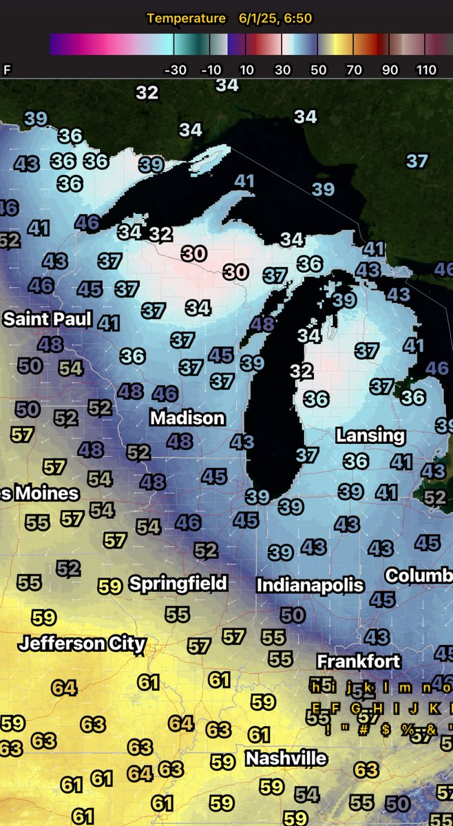
⚠️30s on June 1st?

📉This wild spring continues across the Great Lakes &amp; Ohio Valley, with the coldest start to meteorological summer in decades for many. 

🎯 Don’t miss today’s Weeks Ahead commodity report at <a href="/bam_weather/">BAM Weather</a> for details on what’s in store ahead.

#AGwx #natgas
Kirk 🇺🇸 Hinz | BAM ⚡️Weather (@met_khinz) 's Twitter Profile Photo

From our team at BAM Weather A pattern flip is coming and it's one that will feature more of a classic summertime upper level flow. A ridge of high pressure will develop in the central plains and turn very hot, while this happens the jet stream will divert up and over the