UNT Emergency Management (@meangreenready) 's Twitter Profile
UNT Emergency Management

@meangreenready

Be #MeanGreenReady! Our mission is to create a culture of readiness by ensuring the #UNT community is actively involved in emergency preparedness 💚💪🦅

ID: 2450343793

linkhttps://linktr.ee/meangreenready calendar_today17-04-2014 19:48:17

5,5K Tweet

4,4K Takipçi

2,2K Takip Edilen

UNT Emergency Management (@meangreenready) 's Twitter Profile Photo

The #UNT at Frisco campus is now under Severe Thunderstorm Warning! Hail and strong winds are the main threats. Take action: Seek shelter inside a sturdy building. Visit weather.gov/fwd for more information.

The #UNT at Frisco campus is now under Severe Thunderstorm Warning! Hail and strong winds are the main threats. Take action: Seek shelter inside a sturdy building. 

Visit weather.gov/fwd for more information.
UNT Emergency Management (@meangreenready) 's Twitter Profile Photo

A severe thunderstorm watch has been issued for parts of Texas until 4 AM that includes all UNT campuses. This storm is a particularly dangerous situation. Please stay WEATHER AWARE #UNT

A severe thunderstorm watch has been issued for parts of Texas until 4 AM that includes all UNT campuses. This storm is a particularly dangerous situation. 
Please stay WEATHER AWARE #UNT
UNTEagleAlert (@unteaglealert) 's Twitter Profile Photo

Eagle Alert! A Particularly Dangerous Situation watch has been issued for the UNT campuses and Discovery Park in Denton. Threats may include strong and violent tornadoes and high winds. Stay weather aware and indoors.

UNTEagleAlert (@unteaglealert) 's Twitter Profile Photo

Eagle Alert! A Particularly Dangerous Situation watch has been issued for the UNT campuses in Frisco. Threats may include strong and violent tornadoes and high winds. Stay weather aware and indoors. manager.everbridge.net/pub/2056775549…

UNT Emergency Management (@meangreenready) 's Twitter Profile Photo

Both #UNT campuses in Denton and Frisco are under a Severe Thunderstorm Warning! Hail and strong winds are the main threats. Take action: Seek shelter inside a sturdy building. Visit weather.gov/fwd for more information.

Both #UNT campuses in Denton and Frisco are under a Severe Thunderstorm Warning! 

Hail and strong winds are the main threats. Take action: Seek shelter inside a sturdy building. 

Visit weather.gov/fwd for more information.
UNTEagleAlert (@unteaglealert) 's Twitter Profile Photo

Eagle Alert! A SEVERE THUNDERSTORM WARNING with HIGH WIND has been issued for the UNT campus and Discovery Park in Denton. SEEK SHELTER IMMEDIATELY in an interior room on the lowest level of the nearest building. Avoid windows and glass. Remain inside until further notice.

UNT Facilities (@untfacilities) 's Twitter Profile Photo

June is National Safety Month, and here at UNT, we are always working to keep our campus community safe! Shoutout to our incredible partners over at UNT Emergency Management for working with our team to maintain and improve our safety features around campus💚

NWS Fort Worth (@nwsfortworth) 's Twitter Profile Photo

Morning showers and storms will gradually decrease through the day Friday, with most precipitation likely gone around sunset. A few storms may contain cloud to ground lightning and gusty winds, but severe weather is not expected. #ctxwx #texomawx #dfwwx

Morning showers and storms will gradually decrease through the day Friday, with most precipitation likely gone around sunset. A few storms may contain cloud to ground lightning and gusty winds, but severe weather is not expected. #ctxwx #texomawx #dfwwx
NWS Fort Worth (@nwsfortworth) 's Twitter Profile Photo

Temperatures will climb to above-normal values by the middle of next week as high pressure strengthens overhead. There will be a chance of storms along the Red River, with a 10-20% chance of these storms making it south to the I-20 corridor on Sunday. #texomawx #dfwwx #ctxwx

Temperatures will climb to above-normal values by the middle of next week as high pressure strengthens overhead. There will be a chance of storms along the Red River, with a 10-20% chance of these storms making it south to the I-20 corridor on Sunday. #texomawx #dfwwx #ctxwx
Texas Division of Emergency Management (@tdem) 's Twitter Profile Photo

☔️Rainfall continues to pose a serious flood threat across parts of Texas. Monitor local forecast information, ensure you have a way to receive information from local officials, and never drive through flooded roads Flood Safety Info: ready.gov/floods #txwx

☔️Rainfall continues to pose a serious flood threat across parts of Texas.

Monitor local forecast information, ensure you have a way to receive information from local officials, and never drive through flooded roads

Flood Safety Info: ready.gov/floods

#txwx
NWS Fort Worth (@nwsfortworth) 's Twitter Profile Photo

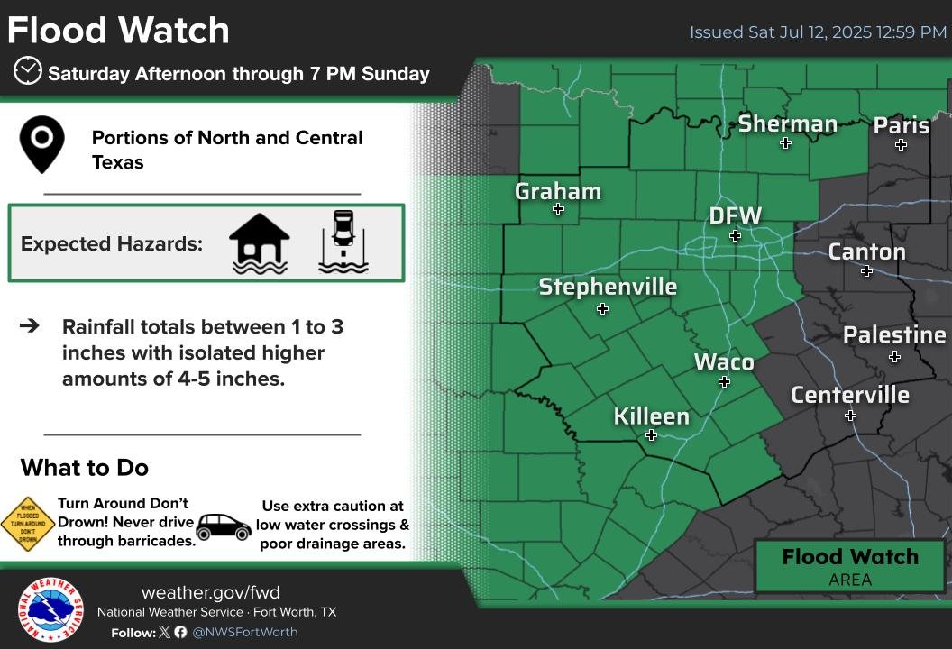
The Flood Watch has been extended to include areas along/near the I-35 of Central TX this afternoon until 7 PM Sunday. Rainfall totals of 1-3 inches, with isolated higher amounts of 4-5 inches. Remain weather aware, and never drive through flooded roads.

The Flood Watch has been extended to include areas along/near the I-35 of Central TX this afternoon until 7 PM Sunday. Rainfall totals of 1-3 inches, with isolated higher amounts of 4-5 inches. Remain weather aware, and never drive through flooded roads.
NWS Fort Worth (@nwsfortworth) 's Twitter Profile Photo

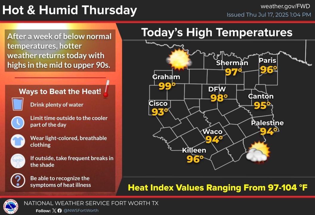
Hot and humid conditions are expected today with high temperatures in the mid to upper 90s and afternoon heat index values ranging from 97 to 104 degrees. Practice proper heat safety if spending extended periods of time outdoors! #txwx #dfwwx #ctxwx

Hot and humid conditions are expected today with high temperatures in the mid to upper 90s and afternoon heat index values ranging from 97 to 104 degrees. Practice proper heat safety if spending extended periods of time outdoors! #txwx #dfwwx #ctxwx
UNT Emergency Management (@meangreenready) 's Twitter Profile Photo

Heads Up #UNT! Temperatures will be in the mid to upper 90s by the end of the week and into the weekend. Make sure to practice heat safety wherever you are!

Heads Up #UNT!

Temperatures will be in the mid to upper 90s by the end of the week and into the weekend. Make sure to practice heat safety wherever you are!
UNT Emergency Management (@meangreenready) 's Twitter Profile Photo

Heads up #UNT! A controlled burn is scheduled to take place at UNT's Discovery Park in the east field (Pollinative Prairie) on July 30th from 10am to 12pm. These burns play a vital role in maintaining healthy ecosystems by re-seeding wildflowers and minimizing invasive species.

Heads up #UNT!

A controlled burn is scheduled to take place at UNT's Discovery Park in the east field (Pollinative Prairie) on July 30th from 10am to 12pm.

These burns play a vital role in maintaining healthy ecosystems by re-seeding wildflowers and minimizing invasive species.
UNT Emergency Management (@meangreenready) 's Twitter Profile Photo

Last week, our Associate Director, Corey, spoke at #CampusSafety2025 in Austin alongside UT's Derek Trabon on risk & resilience for campus safety pros. @meangreenready x UT Security and Emergency Management #highereducation #safety #resilience #emergencymanagement

Last week, our Associate Director, Corey, spoke at #CampusSafety2025 in Austin alongside UT's Derek Trabon on risk & resilience for campus safety pros.

@meangreenready x <a href="/UTAustinSEM/">UT Security and Emergency Management</a> 

#highereducation #safety #resilience #emergencymanagement
UNT Emergency Management (@meangreenready) 's Twitter Profile Photo

Good morning, #Eagles! As a reminder, Denton FD is expected to conduct a 2-hour controlled burn today at #UNT's Discovery Park Pollinative Prairie at 10am. Plan ahead for disruptions and closures during this event. #untparking #untfacilities #untcontrolledburn #meangreenready

Good morning, #Eagles!

As a reminder, Denton FD is expected to conduct a 2-hour controlled burn today at #UNT's Discovery Park Pollinative Prairie at 10am.

Plan ahead for disruptions and closures during this event.

#untparking #untfacilities #untcontrolledburn #meangreenready
UNT Emergency Management (@meangreenready) 's Twitter Profile Photo

It's kickoff time! For this #NationalPreparednessMonth think of preparing for disasters like you would for game day! Make a plan, gather some resources, and make your emergency contact list! Let's #GMG!

It's kickoff time! For this #NationalPreparednessMonth think of preparing for disasters like you would for game day! Make a plan, gather some resources, and make your emergency contact list! Let's #GMG!
UNT Emergency Management (@meangreenready) 's Twitter Profile Photo

Heads up, #Eagles! The National Weather Service (NWS) is predicting that a cold front coming through tonight will bring a few strong to severe storms. For tonight's weather event the primary threat to #UNT will be large hail and high winds. Stay weather aware and be #prepared!

Heads up, #Eagles!

The National Weather Service (NWS) is predicting that a cold front coming through tonight will bring a few strong to severe storms. For tonight's weather event the primary threat to #UNT will be large hail and high winds. 

Stay weather aware and be #prepared!