
LINZ Data Service (@linzlds) 's Twitter Profile
LINZ Data Service

@linzlds

The LINZ Data Service provides free & open access to LINZ's land & sea data. ToU: bit.ly/1Qg7yXD. Follow @LandInfoNZ for LINZ latest news & announcements

ID: 316232211

linkhttp://data.linz.govt.nz/ calendar_today13-06-2011 04:09:00

1,1K Tweet

2,2K Followers

306 Following

LINZ Data Service (@linzlds) 's Twitter Profile Photo

🏞️Discover the beautiful South Wairarapa District like never before! 📸We've just published a new 0.075m urban imagery covering Featherston, Greytown, Lake Ferry, Mangatoetoe, Martinborough, Ngawi, Pirinoa, and Whatarangi. 🚀Check it out on data.linz.govt.nz/layer/122157 (Image: Ngawi)

🏞️Discover the beautiful South Wairarapa District like never before! 📸We've just published a new 0.075m urban imagery covering Featherston, Greytown, Lake Ferry, Mangatoetoe, Martinborough, Ngawi, Pirinoa, and Whatarangi.
🚀Check it out on data.linz.govt.nz/layer/122157 (Image: Ngawi)
LINZ Data Service (@linzlds) 's Twitter Profile Photo

🙌Day 3 of new data drops and we’ve saved a stunner. Feast your eyes on Aoraki/Mount Cook & Cameron Glacier in breathtaking detail👀 (images attached). This completes the final piece of the Canterbury LiDAR release! Dive into the data: data.linz.govt.nz/layer/111133 #OpenData #LiDAR

🙌Day 3 of new data drops and we’ve saved a stunner. Feast your eyes on Aoraki/Mount Cook & Cameron Glacier in breathtaking detail👀 (images attached). This completes the final piece of the Canterbury LiDAR release! Dive into the data:  data.linz.govt.nz/layer/111133 
#OpenData #LiDAR
LINZ Data Service (@linzlds) 's Twitter Profile Photo

🌟Fresh imagery🥳We've published high-res aerial photos of Napier (5cm) & Hawke's Bay (10cm), covering 790 sq km!📸Captured by Central Hawke's Bay District Council, Hastings District Council & Napier City Council. Explore on LDS: data.linz.govt.nz/layer/122220 data.linz.govt.nz/layer/122219

🌟Fresh imagery🥳We've published high-res aerial photos of Napier (5cm) & Hawke's Bay (10cm), covering 790 sq km!📸Captured by Central Hawke's Bay District Council, Hastings District Council & Napier City Council. 
Explore on LDS: 
data.linz.govt.nz/layer/122220 data.linz.govt.nz/layer/122219
LINZ Data Service (@linzlds) 's Twitter Profile Photo

🌾✨Explore the rural landscapes of Hawke's Bay! Our new dataset features aerial photos at 25cm resolution, covering an area of 16,562 sq km. It's a part of the North Island Weather Event (NIWE) to support resilience and recovery. Access it now👉data.linz.govt.nz/layer/122218 #OpenData

🌾✨Explore the rural landscapes of Hawke's Bay! Our new dataset features aerial photos at 25cm resolution, covering an area of 16,562 sq km. It's a part of the North Island Weather Event (NIWE) to support resilience and recovery. 
Access it now👉data.linz.govt.nz/layer/122218
#OpenData
LINZ Data Service (@linzlds) 's Twitter Profile Photo

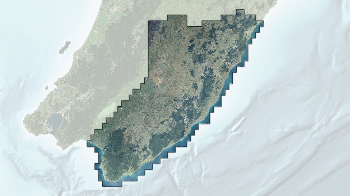
📸New aerial imagery for rural Wellington is also available! 🌄Captured at a high-resolution of 25 cm, this dataset covers 5,794 square kilometers and supports NIWE work. You can view or download it on the LDS: data.linz.govt.nz/layer/122234 #OpenData #NIWE #AerialPhotos #wellington

📸New aerial imagery for rural Wellington is also available! 🌄Captured at a high-resolution of 25 cm, this dataset covers 5,794 square kilometers and supports NIWE work. You can view or download it on the LDS: data.linz.govt.nz/layer/122234
#OpenData #NIWE #AerialPhotos #wellington
LINZ Data Service (@linzlds) 's Twitter Profile Photo

🌄New 20cm rural aerial imagery of the Eastern Bay of Plenty is now available, covering 8,195 sq km, thanks to BOPLASS Ltd. This resource is invaluable for councils, iwi, and emergency services. Dive in to explore! 👉data.linz.govt.nz/layer/122168 #OpenData #AerialPhotos

🌄New 20cm rural aerial imagery of the Eastern Bay of Plenty is now available, covering 8,195 sq km, thanks to BOPLASS Ltd. This resource is invaluable for councils, iwi, and emergency services. 
Dive in to explore! 👉data.linz.govt.nz/layer/122168
#OpenData #AerialPhotos
LINZ Data Service (@linzlds) 's Twitter Profile Photo

🙌A roundup of this week's 5 new Aerial Imagery📸: - Hawke's Bay 10cm data.linz.govt.nz/layer/122219 - Napier 5cm data.linz.govt.nz/layer/122220 - Rural Hawke's Bay 25cm data.linz.govt.nz/layer/122218 - Rural Wellington 25cm data.linz.govt.nz/layer/122234 - Bay of Plenty East 20cm data.linz.govt.nz/layer/122168
🙌A roundup of this week's 5 new Aerial Imagery📸:  
- Hawke's Bay 10cm data.linz.govt.nz/layer/122219
- Napier 5cm data.linz.govt.nz/layer/122220
- Rural Hawke's Bay 25cm data.linz.govt.nz/layer/122218
- Rural Wellington 25cm data.linz.govt.nz/layer/122234
- Bay of Plenty East 20cm data.linz.govt.nz/layer/122168
LINZ Data Service (@linzlds) 's Twitter Profile Photo

🌟Fresh from above! Tauranga 0.1m Urban Aerial Photos (0.1m GSD) is now live. This vibrant new dataset covers about 312 sq km of the Bay of Plenty region. Can you guess where the images were captured? Explore it on LDS: data.linz.govt.nz/layer/122412 on Basemap: basemaps.linz.govt.nz/@-37.7179635,1…

🌟Fresh from above! Tauranga 0.1m Urban Aerial Photos (0.1m GSD) is now live. This vibrant new dataset covers about 312 sq km of the Bay of Plenty region. Can you guess where the images were captured?
Explore it on LDS: data.linz.govt.nz/layer/122412
on Basemap: basemaps.linz.govt.nz/@-37.7179635,1…
LINZ Data Service (@linzlds) 's Twitter Profile Photo

📢New data drop! We've just published the final imagery for Northland 0.3m Rural Aerial Photo (2023-2025) 📸 Part of the North Island Weather Event project, now available on LDS: data.linz.govt.nz/layer/120064 and Basemaps: basemaps.linz.govt.nz/@-35.4248681,1… #OpenData #AerialImagery #Northland

📢New data drop! We've just published the final imagery for Northland 0.3m Rural Aerial Photo (2023-2025) 📸
Part of the North Island Weather Event project, now available on LDS: data.linz.govt.nz/layer/120064
and Basemaps: basemaps.linz.govt.nz/@-35.4248681,1…
#OpenData #AerialImagery #Northland
LINZ Data Service (@linzlds) 's Twitter Profile Photo

📸Just released the latest 24/25 aerial imagery of the Tasman region!🌄This 0.25m imagery covers approximately 5590km² of the upper South Island. Check it out on Basemaps: basemaps.linz.govt.nz/@-41.3118099,1… and on LDS: data.linz.govt.nz/layer/122529-t… (Image: Bell Island and Best Island) #OpenData
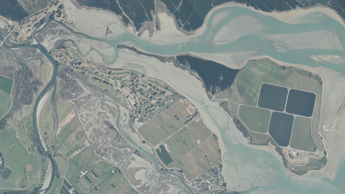
📸Just released the latest 24/25 aerial imagery of the Tasman region!🌄This 0.25m imagery covers approximately 5590km² of the upper South Island. Check it out on Basemaps: basemaps.linz.govt.nz/@-41.3118099,1… 
and on LDS: data.linz.govt.nz/layer/122529-t…
(Image: Bell Island and Best Island) #OpenData
LINZ Data Service (@linzlds) 's Twitter Profile Photo

New urban imagery has just been published for Carterton. 📸Check it out on LINZ Data Service and LINZ Basemaps. Thanks to Carterton District Council for making this happen! #opendata 📍data.linz.govt.nz/layer/122651-c… 📍basemaps.linz.govt.nz/v1/link/carter… (Image: Hockey Wairarapa, Carterton)

New urban imagery has just been published for Carterton. 📸Check it out on LINZ Data Service and LINZ Basemaps. Thanks to Carterton District Council for making this happen! #opendata 
📍data.linz.govt.nz/layer/122651-c…
📍basemaps.linz.govt.nz/v1/link/carter…
(Image: Hockey Wairarapa, Carterton)
LINZ Data Service (@linzlds) 's Twitter Profile Photo

🤩Wow! Check out the new 4cm urban imagery just published for Waimakariri. Now available on LDS and LINZ Basemaps. Thanks to Waimakariri District Council 🙌#opendata Check it out here: data.linz.govt.nz/layer/122655-w… basemaps.linz.govt.nz/v1/link/waimak… (Image: Cricket being played at Rangiora Recreation Ground)
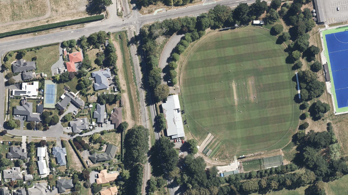
🤩Wow! Check out the new 4cm urban imagery just published for Waimakariri. Now available on LDS and LINZ Basemaps. Thanks to <a href="/waimakariridc/">Waimakariri District Council</a> 🙌#opendata
Check it out here: 
data.linz.govt.nz/layer/122655-w…
basemaps.linz.govt.nz/v1/link/waimak…
(Image: Cricket being played at Rangiora Recreation Ground)
LINZ Data Service (@linzlds) 's Twitter Profile Photo

🚨New Data! Part 2 of the Auckland LiDAR datasets (2024) is now live on LDS: data.linz.govt.nz/layer/122580/ 🌋 This dataset covers 3,507 km² of Auckland, including stunning elevation data of Rangitoto Island’s lava flows and surrounding terrain. (PC Image: Rangitoto Island stylised DEM)

🚨New Data! Part 2 of the Auckland LiDAR datasets (2024) is now live on LDS: data.linz.govt.nz/layer/122580/ 🌋
This dataset covers 3,507 km² of Auckland, including stunning elevation data of Rangitoto Island’s lava flows and surrounding terrain.
(PC Image: Rangitoto Island stylised DEM)
LINZ Data Service (@linzlds) 's Twitter Profile Photo

🚁Explore Auckland in stunning detail! 📸The updated high-res 7.5cm urban imagery captured by Auckland Council (Auckland Council) now has full region coverage! Check it out now on: 🔗data.linz.govt.nz/layer/121752 🗺️basemaps.linz.govt.nz/v1/link/auckla…  📍Image: Parakai #opendata #auckland #aerialimagery
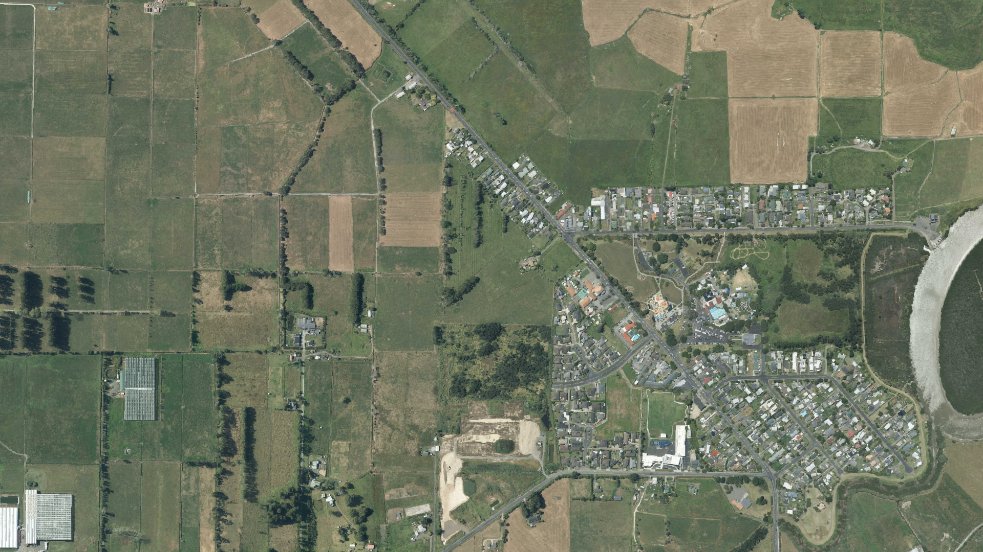
🚁Explore Auckland in stunning detail! 📸The updated high-res 7.5cm urban imagery captured by Auckland Council (<a href="/AklCouncil/">Auckland Council</a>) now has full region coverage! Check it out now on:
🔗data.linz.govt.nz/layer/121752
🗺️basemaps.linz.govt.nz/v1/link/auckla… 
📍Image: Parakai
#opendata #auckland #aerialimagery
LINZ Data Service (@linzlds) 's Twitter Profile Photo

📸The updated 2025 urban aerial photos (0.075m GSD) for Upper Hutt and Hutt City are now live on Basemaps and LDS!  Check them out and see what’s changed from above! 🚁✨ 🔗LDS: bit.ly/4mdsDat 🗺️(Upper Hutt): basemaps.linz.govt.nz/@-41.1208359,1… 🗺️(Hutt City): basemaps.linz.govt.nz/@-41.2323801,1…

📸The updated 2025 urban aerial photos (0.075m GSD) for Upper Hutt and Hutt City are now live on Basemaps and LDS!  Check them out and see what’s changed from above! 🚁✨
🔗LDS: bit.ly/4mdsDat
🗺️(Upper Hutt): basemaps.linz.govt.nz/@-41.1208359,1…
🗺️(Hutt City): basemaps.linz.govt.nz/@-41.2323801,1…
LINZ Data Service (@linzlds) 's Twitter Profile Photo

🚨West Coast LiDAR is now complete! The final block of data has landed, bringing full regional coverage. And Aoraki/Mt Cook is fully captured across both West Coast & Canterbury 🏔️✨ Explore now👉data.linz.govt.nz/layer/110163 Images: Top-down & Oblique views of Aoraki/Mt Cook #OpenData

🚨West Coast LiDAR is now complete! The final block of data has landed, bringing full regional coverage. And Aoraki/Mt Cook is fully captured across both West Coast &amp; Canterbury 🏔️✨
Explore now👉data.linz.govt.nz/layer/110163
Images: Top-down &amp; Oblique views of Aoraki/Mt Cook
#OpenData
LINZ Data Service (@linzlds) 's Twitter Profile Photo

The Masterton 0.075m Urban Aerial Photos (2025) are now live on LDS and Basemaps. Explore the latest high-res imagery and see how the urban landscape has evolved since the last update in 2021. 🔗LDS: data.linz.govt.nz/layer/122713-m… 🗺️Basemaps: basemaps.linz.govt.nz/@-41.0210406,1… (Images: Masterton)
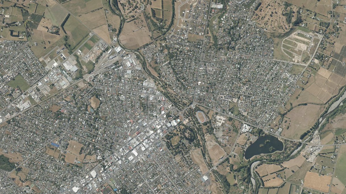
The Masterton 0.075m Urban Aerial Photos (2025) are now live on LDS and Basemaps. Explore the latest high-res imagery and see how the urban landscape has evolved since the last update in 2021.
🔗LDS: data.linz.govt.nz/layer/122713-m…
🗺️Basemaps: basemaps.linz.govt.nz/@-41.0210406,1…
(Images: Masterton)
LINZ Data Service (@linzlds) 's Twitter Profile Photo

🚁New urban aerial imagery is now live for the West Coast! Explore detailed 7.5cm photos from: ▶️Grey data.linz.govt.nz/layer/122667-g… ▶️Westland data.linz.govt.nz/layer/122670-w… ▶️Buller data.linz.govt.nz/layer/122596-b… More imagery coming this summer. 📍Image: Runanga (Grey dataset) #OpenData #WestCoast
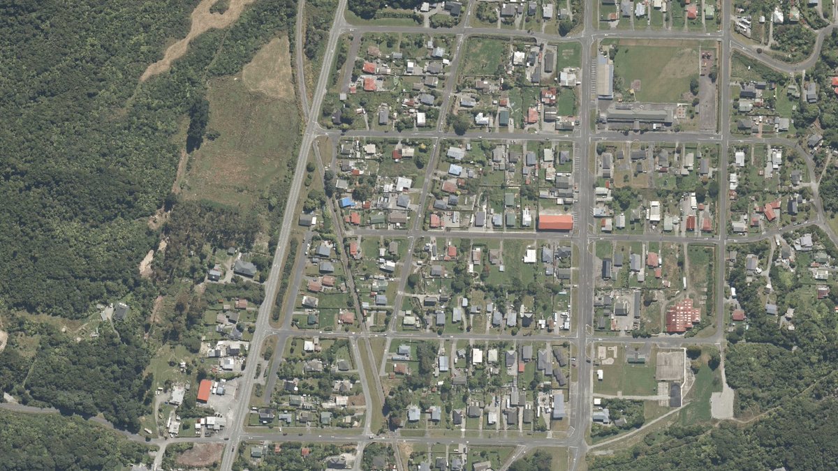
🚁New urban aerial imagery is now live for the West Coast! Explore detailed 7.5cm photos from:
▶️Grey data.linz.govt.nz/layer/122667-g…
▶️Westland data.linz.govt.nz/layer/122670-w…
▶️Buller data.linz.govt.nz/layer/122596-b…
More imagery coming this summer. 
📍Image: Runanga (Grey dataset)
#OpenData #WestCoast
LINZ Data Service (@linzlds) 's Twitter Profile Photo

📢New this week: New NZ Property Boundaries dataset now on LDS and ArcGIS REST - our best representation of property boundaries in NZ 🏠🗺️ Start using it on LDS: data.linz.govt.nz/layer/122657 ArcGIS Online: arcgis.com/home/item.html…

📢New this week: New NZ Property Boundaries dataset now on LDS and ArcGIS REST - our best representation of property boundaries in NZ 🏠🗺️
Start using it on LDS: data.linz.govt.nz/layer/122657
ArcGIS Online: arcgis.com/home/item.html…
LINZ Data Service (@linzlds) 's Twitter Profile Photo

📸Fresh aerial views over Banks Peninsula is now live on LDS! This new 25cm rural imagery, captured by Environment Canterbury, features stunning detail over Akaroa. ⛵️🌄 Check it out here👉data.linz.govt.nz/layer/122717-c… 👀More imagery coming soon 📍Images: Akaroa #OpenData #Canterbury #AerialImagery

📸Fresh aerial views over Banks Peninsula is now live on LDS! This new 25cm rural imagery, captured by <a href="/ECan/">Environment Canterbury</a>, features stunning detail over Akaroa. ⛵️🌄
Check it out here👉data.linz.govt.nz/layer/122717-c…
👀More imagery coming soon
📍Images: Akaroa
#OpenData #Canterbury #AerialImagery