Katie Dupree(@Katiethatwxlady) 's Twitter Profileg
Katie Dupree

@Katiethatwxlady

Community Impact Manager @VDEM. Part-time meteorologist @8News. Wife, mom, cat lady. ⛅️⚡️🌪❄️

ID:249398002

calendar_today08-02-2011 23:47:17

14,8K Tweets

3,9K Followers

1,5K Following

VDOT(@VaDOT) 's Twitter Profile Photo

Our 511 cameras show how different the weather conditions are across Virginia this morning. Before any travel, motorists should check weather forecasts & 511Virginia.org road conditions for your entire route.
📷 US 522 at WVa state line
📷I-95 near NC state line

Our 511 cameras show how different the weather conditions are across Virginia this morning. Before any travel, motorists should check weather forecasts & 511Virginia.org road conditions for your entire route. 📷 US 522 at WVa state line 📷I-95 near NC state line
account_circle
National Guard(@USNationalGuard) 's Twitter Profile Photo

Today, more than 5,200 National Guard members continue to support Hurricane Ian response efforts. Guardsmen from the FloridaNationalGuard and 7 other states have rescued 1,900 people and 50 pets.

account_circle
Katie Dupree(@Katiethatwxlady) 's Twitter Profile Photo

Alright, APStylebook...let's settle this once and for all. When using 'commonwealth' in reference to a particular state, i.e., 'The Commonwealth (of Virginia) will continue to...' should commonwealth be capitalized, as it is a proper noun?

account_circle
Virginia Department of Emergency Management(@VDEM) 's Twitter Profile Photo

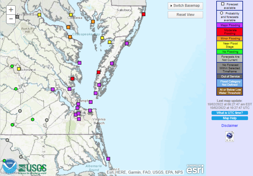
❗️Moderate-major flooding is expected along VA’s coast and rivers through Tuesday.

Water will be 2-3ft above ground level in some areas.

🚧Numerous roads will be impassable.

🚫📱Don't drive through flooded roads, and keep updated on the forecast. weather.gov/akq/

❗️Moderate-major flooding is expected along VA’s coast and rivers through Tuesday. Water will be 2-3ft above ground level in some areas. 🚧Numerous roads will be impassable. 🚫📱Don't drive through flooded roads, and keep updated on the forecast. weather.gov/akq/
account_circle
NWS Wakefield(@NWSWakefieldVA) 's Twitter Profile Photo

A coastal low phases with the remnants of Ian and lingers off the coast through midweek bringing widespread rain and increasing, gusty NNE winds. Water levels rise beginning later today with Major Coastal Flooding expected Monday. Elevated water levels continue into midweek.

A coastal low phases with the remnants of Ian and lingers off the coast through midweek bringing widespread rain and increasing, gusty NNE winds. Water levels rise beginning later today with Major Coastal Flooding expected Monday. Elevated water levels continue into midweek.
account_circle
Katie Dupree(@Katiethatwxlady) 's Twitter Profile Photo

PARENTS: does your child have a warm rain jacket that fits? They're going to need one, especially tomorrow & Tuesday. 🌬🧥☔️ Full forecast ➡️bit.ly/3SN250V

PARENTS: does your child have a warm rain jacket that fits? They're going to need one, especially tomorrow & Tuesday. 🌬🧥☔️ Full forecast ➡️bit.ly/3SN250V
account_circle
NWS Wakefield(@NWSWakefieldVA) 's Twitter Profile Photo

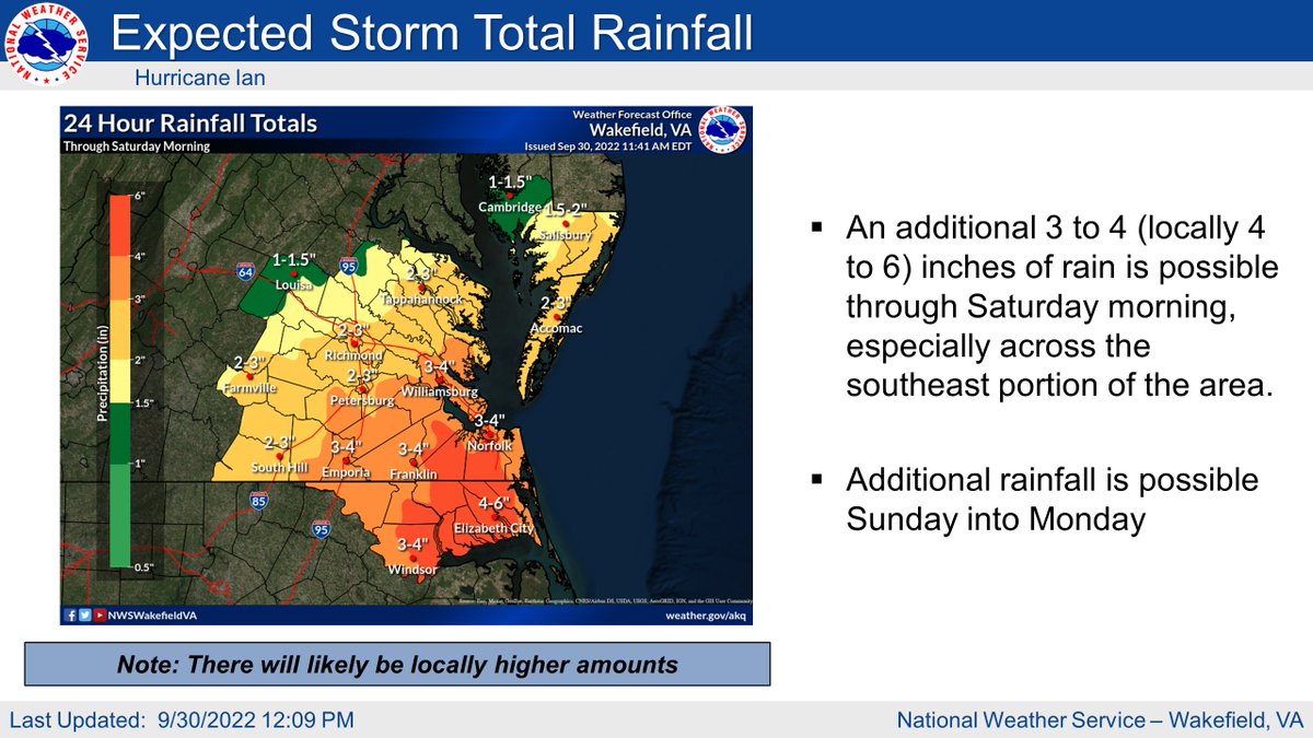
There is now a Moderate Risk of Excessive Rainfall/Flash Flooding for southern portions of our forecast area. We are expecting an additional 3 to 4' (locally 4 to 6') of rain which will lead to instances of flash flooding. The heaviest rain fall this afternoon through tonight

There is now a Moderate Risk of Excessive Rainfall/Flash Flooding for southern portions of our forecast area. We are expecting an additional 3 to 4' (locally 4 to 6') of rain which will lead to instances of flash flooding. The heaviest rain fall this afternoon through tonight
account_circle
Katie Dupree(@Katiethatwxlady) 's Twitter Profile Photo

Tornado threat🌪 in is greatest
tonight and overnight.

Don’t miss 🆘 alerts🚨 because you’re sleeping!

iPhone: go to Settings>Alerts. Make sure you’ve enabled alerts and selected “Always Play Sound”—you’ll get alerts even if your phone’s on silent. Virginia Department of Emergency Management

Tornado threat🌪 in #VA is greatest tonight and overnight. Don’t miss 🆘 alerts🚨 because you’re sleeping! iPhone: go to Settings>Alerts. Make sure you’ve enabled alerts and selected “Always Play Sound”—you’ll get alerts even if your phone’s on silent. @VDEM
account_circle
Katie Dupree(@Katiethatwxlady) 's Twitter Profile Photo

Along with excessive rain and strong winds, there's also a
🌪 TORNADO 🌪 threat with remnants of . NWS Storm Prediction Center puts the best chance in SE . Threat is greatest later this evening and overnight.

Tornadoes are dangerous at any time, but particularly at night. ❗️📱📺📻

Along with excessive rain and strong winds, there's also a 🌪 TORNADO 🌪 threat with remnants of #Ian. @NWSSPC puts the best chance in SE #VA. Threat is greatest later this evening and overnight. Tornadoes are dangerous at any time, but particularly at night. ❗️📱📺📻
account_circle
Katie Dupree(@Katiethatwxlady) 's Twitter Profile Photo

🌀🌧Rain from is arriving in Virginia, and it could cause flooding.

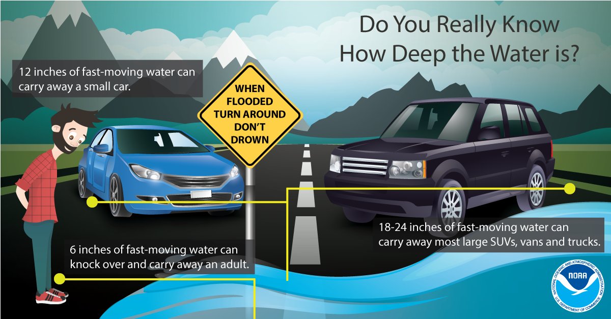
Did you know 1.5-2 feet of water can carry away large SUVs, vans, & trucks?

If you don't know how deep the water is, don't go in it!

Turn Around, Don't Drown! ⚠️

🌀🌧Rain from #Ian is arriving in Virginia, and it could cause flooding. Did you know 1.5-2 feet of water can carry away large SUVs, vans, & trucks? If you don't know how deep the water is, don't go in it! Turn Around, Don't Drown! ⚠️
account_circle
ABC News(@ABC) 's Twitter Profile Photo

Hurricane Ian, a Category 4 with 155 mph winds, is nearing record-breaking wind levels.

Only four hurricanes have ever made landfall in the continental U.S. with winds over 155 mph. abcn.ws/3SFoLAl

Hurricane Ian, a Category 4 with 155 mph winds, is nearing record-breaking wind levels. Only four hurricanes have ever made landfall in the continental U.S. with winds over 155 mph. abcn.ws/3SFoLAl
account_circle
Katie Dupree(@Katiethatwxlady) 's Twitter Profile Photo

Here’s the latest forecast for .

It’s looking increasingly likely that Virginia will see heavy rain from the remnants of this storm.

Are you and your family prepared if there is a flood?

📝Make a plan.
🆘Build a kit.
📱Stay informed.

account_circle
Katie Dupree(@Katiethatwxlady) 's Twitter Profile Photo

Looking forward to being a panelist representing meteorology & Emergency Management at Mid-Atlantic ChaserCon! @MChasercon

account_circle