Kimberly Miller (@kmillerweather) 's Twitter Profile
Kimberly Miller

@kmillerweather

Real estate and growth reporter for The Palm Beach Post. Certificate in Weather Forecasting, Penn State. Surfer, dog walker. University of Arizona.

ID: 3300649631

linkhttp://www.palmbeachpost.com/news calendar_today27-05-2015 17:24:26

11,11K Tweet

4,4K Takipçi

1,1K Takip Edilen

Chris Wicklund Auroras (@wickydubs2) 's Twitter Profile Photo

For you hurricane hunters / general public. The recent cuts for NHC has downed 2 flight directors who help fly the Air Force into hurricanes. The cuts according to NOAA staffers might make flights once or zero times per day instead of the two rounds they make per day for data.

For you hurricane hunters / general public. The recent cuts for NHC has downed 2 flight directors who help fly the Air Force into hurricanes. 

The cuts according to NOAA staffers might make flights once or zero times per day instead of the two rounds they make per day for data.
National Hurricane Center (@nhc_atlantic) 's Twitter Profile Photo

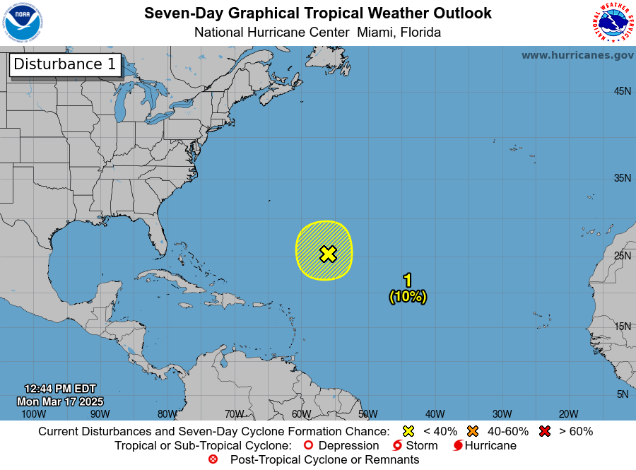
1220 pm EDT March 17: A non-tropical low located about 700 miles northeast of the northern Leeward Islands is producing gale-force winds and a large area of disorganized showers and thunderstorms. Additional development is not expected as it moves into an environment of strong

1220 pm EDT March 17:  A non-tropical low located about 700 miles  northeast of the northern Leeward Islands is producing gale-force winds and a large area of disorganized showers and thunderstorms.  Additional development is not expected as it moves into an environment of strong
Kimberly Miller (@kmillerweather) 's Twitter Profile Photo

Can a billionaire buy a public street in West Palm Beach? And, are you plagued by 'middle class eye roll syndrome' or MCERS? Find out in The Dirt! palmbeachpost.com/story/news/202… via The Palm Beach Post

Philip Klotzbach (@philklotzbach) 's Twitter Profile Photo

For those wondering how Colorado State University became a #hurricane forecast hotspot despite being in a landlocked state, here's a podcast that we recorded last year: source.colostate.edu/how-did-the-pr…

Craig Setzer, CCM (@craigsetzer) 's Twitter Profile Photo

South Florida atmosphere supports storms that could produce hail this afternoon. Already happened this morning just up the road.

NOAA Climate.gov (@noaaclimate) 's Twitter Profile Photo

La Niña has ended, and the tropical Pacific is now in a neutral state—neither La Niña nor El Niño. Without those patterns influencing the atmosphere, it’s harder to anticipate seasonal shifts in rain or temperatures. Neutral likely lasts through fall. climate.gov/news-features/…

NWS Miami (@nwsmiami) 's Twitter Profile Photo

GOES-19 Imagery (NOAA Satellites) of our area this afternoon shows widespread low level cumulus clouds as a weak front continues to move southward away from the region. The drought across our region will continue to worsen as no rainfall is forecast over the next 7 days.

Kimberly Miller (@kmillerweather) 's Twitter Profile Photo

Don't try to pet an alligator when you're drunk and other tips on how to avoid getting bitten by Florida's favorite reptile. palmbeachpost.com/story/news/202… via The Palm Beach Post

South Florida Water Management District (@sfwmd) 's Twitter Profile Photo

🌞💧It's not quite summer yet, but in Central and Southern Florida the temperatures are already rising and we are experiencing very dry conditions. Use these #WaterConservation tips year-round: Embrace FL-Friendly Landscaping Use a smart irrigation controller Find & fix leaks

Adrian Linares (@adrianlinares28) 's Twitter Profile Photo

Wow! NWS Miami Never thought I’d ever see my backyard in Lake Worth Florida covered in quarter size hail. The sounds you here in the video is hail hitting my webcam. Peak gusts 53 mph. #FLwx

Andy Hazelton (@andyhazelton) 's Twitter Profile Photo

With the continued drought in South Florida, the rural area just south of Homestead and Florida City continues to be a hotspot for wildfires. Second time in recent months that a fire has closed the roads into and out of the Keys.

Andy Hazelton (@andyhazelton) 's Twitter Profile Photo

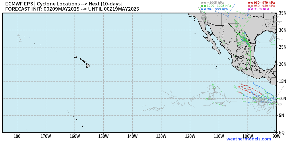
Not surprisingly, GFS has dropped its long range fantasy Caribbean storm. It seems likely that any development in the next couple weeks will be on the East Pacific side of Central America. Pretty typical for this time of year.

Not surprisingly, GFS has dropped its long range fantasy Caribbean storm. It seems likely that any development in the next couple weeks will be on the East Pacific side of Central America. Pretty typical for this time of year.
NWS Miami (@nwsmiami) 's Twitter Profile Photo

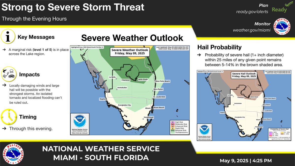
May 9 @ 4:30 PM - Locally damaging winds and large hail will be possible with the strongest storms through this evening with a focus around Lake Okeechobee. An isolated tornado and localized flooding can’t be ruled out. #FLwx

May 9 @ 4:30 PM - Locally damaging winds and large hail will be possible with the strongest storms through this evening with a focus around Lake Okeechobee. An isolated tornado and localized flooding can’t be ruled out. #FLwx
NHC_TAFB (@nhc_tafb) 's Twitter Profile Photo

The first #TropicalWave of 2025 has been analyzed for the 18z Surface Analysis map! While tropical cyclone development is not anticipated with this wave at this time, these waves can still produce heavy rain & gusty winds. For more info, visit hurricanes.gov/marine! #marinewx

NWS Miami (@nwsmiami) 's Twitter Profile Photo

It'll be another hot day across South Florida today with forecast afternoon high temperatures in the 90s and feels-like temperatures in the 100-105°F range this afternoon. Be sure to hydrate, take breaks in cool places, and limit outdoor activities from 10am-4pm if possible!

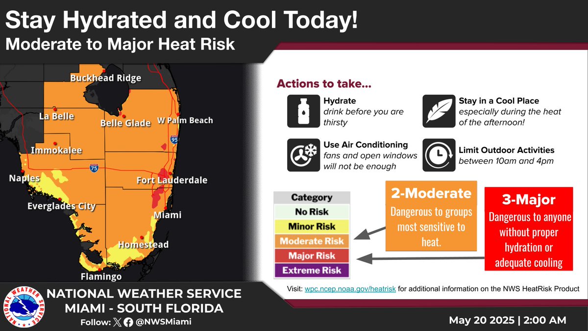
It'll be another hot day across South Florida today with forecast afternoon high temperatures in the 90s and feels-like temperatures in the 100-105°F range this afternoon. Be sure to hydrate, take breaks in cool places, and limit outdoor activities from 10am-4pm if possible!
NWS Miami (@nwsmiami) 's Twitter Profile Photo

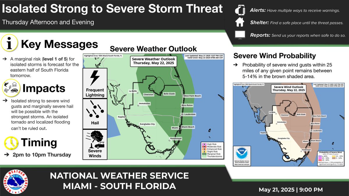
*Heads Up* Outlook: Isolated strong to severe storms will be possible tomorrow from 2pm-10pm across the eastern half of South Florida. Hazards with the strongest storms: - Strong to severe wind gusts - Small to marginally severe hail - Frequent lightning - Localized flooding

*Heads Up* Outlook: Isolated strong to severe storms will be possible tomorrow from 2pm-10pm across the eastern half of South Florida.

Hazards with the strongest storms:
- Strong to severe wind gusts
- Small to marginally severe hail
- Frequent lightning
- Localized flooding
David Zierden (@flclimatecenter) 's Twitter Profile Photo

After a wet spell a couple weeks ago, hot and dry weather returned to Florida and moderate (D1) to extreme (D3) continues across the peninsula....

After a wet spell a couple weeks ago, hot and dry weather returned to Florida and moderate (D1) to extreme (D3) continues across the peninsula....
FL Division of Emergency Management (@flsert) 's Twitter Profile Photo

🌀The 2025 Atlantic Hurricane Season officially begins this Sunday, June 1! The season runs through November 30, & throughout it, you may hear or see some unfamiliar weather terms. Learn more about tropical weather terms below so you can best act & prepare before a storm.

🌀The 2025 Atlantic Hurricane Season officially begins this Sunday, June 1!

The season runs through November 30, & throughout it, you may hear or see some unfamiliar weather terms.

Learn more about tropical weather terms below so you can best act & prepare before a storm.
National Hurricane Center (@nhc_atlantic) 's Twitter Profile Photo

A non-tropical low is expected to form on Thursday, but likely inland over the Carolinas—reducing chances for tropical or subtropical development. Formation chances have dropped to near 0%, but heavy rain & flash flooding are still possible along the SE coast through Thursday.

A non-tropical low is expected to form on Thursday, but likely inland over the Carolinas—reducing chances for tropical or subtropical development.  

Formation chances have dropped to near 0%, but heavy rain & flash flooding are still possible along the SE coast through Thursday.
Bryan Norcross (@bryannorcrosstv) 's Twitter Profile Photo

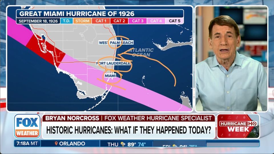
WHAT CAN WE LEARN FROM HURRICANE HISTORY? What if the great hurricanes of the past happened again? How do you judge how bad they would be today? And which ones would be included on the list of the most damaging if they happened again? Here my report on FOX Weather.
WHAT CAN WE LEARN FROM HURRICANE HISTORY? What if the great hurricanes of the past happened again? How do you judge how bad they would be today? And which ones would be included on the list of the most damaging if they happened again? Here my report on <a href="/foxweather/">FOX Weather</a>.