Matt AKA Fuzzy (@fuzzywx) 's Twitter Profile
Matt AKA Fuzzy

@fuzzywx

Weather nerd since I was 3 years old. hero's are @ReedTimmerUSA @MikeMorganKFOR, @TornadoGreg. Huge fan of @stormfrontfreak WWE fan. @stormfrontfreak YT Mod

ID: 4305568934

calendar_today20-11-2015 22:43:50

33,33K Tweet

1,1K Followers

5,5K Following

Simon Brewer (@simonstormrider) 's Twitter Profile Photo

Think Juston Drake agrees with me that the past 3 years (2023-2025) have been absolutely incredible for tornadoes as storm chasers. And to think next year, 2026, could potentially be another big year would be insane! #tornadoes

Think <a href="/JustonStrmRider/">Juston Drake</a> agrees with me that the past 3 years (2023-2025) have been absolutely incredible for tornadoes as storm chasers. And to think next year, 2026, could potentially be another big year would be insane! #tornadoes
Matthew Cappucci (@matthewcappucci) 's Twitter Profile Photo

For our Spanish-speaking audience in the Caribbean, I’ve been working to produce a second set of graphics so Mauricio, our bilingual editor, can produce a Spanish-language forecast. Check out our Español tab in the MyRadar Weather app!

BobbiStorm (@bobbistorm) 's Twitter Profile Photo

NHC raised intensity forecast to 130 MPH (5 days from now) til then she's struggles. A house divided against itself rarely gets anywhere. At some 1 center is left-in theory if end game Major Cane verifies. Checkback tomorrow if forecast verifies she'll be 48 miles further ...

Josh Morgerman (@icyclone) 's Twitter Profile Photo

Enjoying a quiet night in the Bay. Steeling myself for what I know is going to be a tough expedition to I Don't Know Where to chase I Don't Know What. But sometimes the best course of action is just be still & observe—like right now. Too soon to make a move. #MELISSA

Enjoying a quiet night in the Bay. Steeling myself for what I know is going to be a tough expedition to I Don't Know Where to chase I Don't Know What. But sometimes the best course of action is just be still &amp; observe—like right now. Too soon to make a move. #MELISSA
Aaron Jayjack (@aaronjayjack) 's Twitter Profile Photo

There have been a few times in my career where I've looked at a tornado that I'm intercepting and I've thought "Wow. That is an EF5." None stand out to me more than the July 2023 Didsbury, Alberta tornado. As I made my way toward two destroyed homes I said to myself "that's an

Josh Morgerman (@icyclone) 's Twitter Profile Photo

When you're bugging out at the hurricane models, remember that winds at 850 mb are *not* surface winds and therefore not representative of intensity. Refer to the 10 m view for surface winds.

Storm Front Freaks Network “⭐️⭐️⭐️⭐️⭐️” (@stormfrontfreak) 's Twitter Profile Photo

ONE DAY UNTIL THE PODCAST FINALE!!! Don’t miss it! Thursday 10/23 @ 9pmET/8pmCT LIVE on YT. See our profile for link! Surprise guests and amazing video compilations. Oh, and drinking. Come prepared.

ONE DAY UNTIL THE PODCAST FINALE!!!

Don’t miss it!  Thursday 10/23 @ 9pmET/8pmCT LIVE on YT.  See our profile for link!

Surprise guests and amazing video compilations. Oh, and drinking.  Come prepared.
Collin Gross (@collingrosswx) 's Twitter Profile Photo

A blocking high will keep #Melissa in the Caribbean longer. Why does this matter? The storm will be over exceptionally high ocean heat content, enough to support a high end hurricane. And as shear lessens this weekend, conditions will be prime for rapid intensification.

A blocking high will keep #Melissa in the Caribbean longer. Why does this matter? The storm will be over exceptionally high ocean heat content, enough to support a high end hurricane. And as shear lessens this weekend, conditions will be prime for rapid intensification.
Max Velocity (@maxvelocitywx) 's Twitter Profile Photo

Concerning trends continue for upcoming Hurricane Melissa, which is set to become a Category 4 or 5 hurricane near Jamaica and Cuba... I cannot stress enough how devastating this hurricane could be to these islands. This hurricane will move VERY slowly near Jamaica for the next

Concerning trends continue for upcoming Hurricane Melissa, which is set to become a Category 4 or 5 hurricane near Jamaica and Cuba...

I cannot stress enough how devastating this hurricane could be to these islands. This hurricane will move VERY slowly near Jamaica for the next
Matthew Cappucci (@matthewcappucci) 's Twitter Profile Photo

11 PM Update – MAJOR hurricane is likely by Sunday into Monday. After struggling/stalling through Friday, Melissa is expected to rapidly intensify over the weekend, likely into a Category 4+ hurricane. What we're showing you is the Google DeepMind AI model – which has exhibited

11 PM Update – MAJOR hurricane is likely by Sunday into Monday. After struggling/stalling through Friday, Melissa is expected to rapidly intensify over the weekend, likely into a Category 4+ hurricane.

What we're showing you is the Google DeepMind AI model – which has exhibited
Simon Brewer (@simonstormrider) 's Twitter Profile Photo

OTD 25 years ago, October 22, 2000, I saw my first tornado over the Southeast-side of Oklahoma City, OK with Jim Bishop. Saw powerflashes from a tornado near Crossroads Mall. Later, we were hit by possibly the same circulation northeast of the mall. #OKwx


OTD 25 years ago, October 22, 2000, I saw my first tornado over the Southeast-side of Oklahoma City, OK with <a href="/StormgasmJim/">Jim Bishop</a>.
Saw powerflashes from a tornado near Crossroads Mall. Later, we were hit by possibly the same circulation northeast of the mall. #OKwx

Max Velocity (@maxvelocitywx) 's Twitter Profile Photo

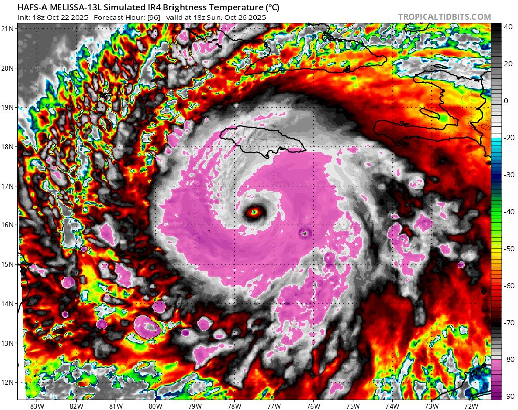
HAFS Hurricane Model continues to show Melissa as an incredibly powerful hurricane near Jamaica on Sunday... It's rare that a hurricane model shows a sub-900mb hurricane being forecasted 3+ days in advance like this. This upcoming hurricane could cause catastrophic impacts to

HAFS Hurricane Model continues to show Melissa as an incredibly powerful hurricane near Jamaica on Sunday...

It's rare that a hurricane model shows a sub-900mb hurricane being forecasted 3+ days in advance like this. This upcoming hurricane could cause catastrophic impacts to
Brady Harris (@stormcat5_) 's Twitter Profile Photo

We need to keep a CLOSE eye on any westward or southward jogs from #Melissa in the coming days. Right now, Melissa’s ticket north is a Trough that'll move over the U.S. early next week. At the moment, the U.S. isn’t in the discussion for direct impacts, BUT if future Hurricane