Scott Jankowski (@eyewalladdict) 's Twitter Profile
Scott Jankowski

@eyewalladdict

Hurricane chaser and amateur hurricane research scientist.

ID: 1810750211159203840

linkhttp://www.youtube.com/@eyewalladdict calendar_today09-07-2024 18:57:56

330 Tweet

98 Followers

131 Following

Weather Monitor (@weathermonitors) 's Twitter Profile Photo

BREAKING: Massive Glacier Collapse in Blatten, Valais (Switzerland) – May 28, 2025 Over 3.5 million m³ of ice, rock, and snow collapsed from the Birch Glacier, putting 9 million tons of pressure on the glacier. The entire village of Blatten (approx. 300 people) was evacuated in

Danilo Evangelista (@daniloevan11) 's Twitter Profile Photo

Tropical Storm Alvin has now formed in the eastern pacific. It is expected 60 mph within the next 24 hours before weakening as it moves northward this weekend. No major impacts to Mexico expected...

Tropical Storm Alvin has now formed in the eastern pacific. It is expected 60 mph within the next 24 hours before weakening as it moves northward this weekend. No major impacts to Mexico expected...
IPTCWC (@iptcwc) 's Twitter Profile Photo

Cyclonic Storm #Two-NI Advisory #1: New tropical storm forms, makes landfall in #Bangladesh. Max sustained winds are at 35kts (40mph). Heavy to torrential rains and strong winds to occur while the system moves inland. Click on cone and discussion for more information.

Cyclonic Storm #Two-NI Advisory #1: New tropical storm forms, makes landfall in #Bangladesh. Max sustained winds are at 35kts (40mph). Heavy to torrential rains and strong winds to occur while the system moves inland. Click on cone and discussion for more information.
Mike Masco (@mikemasco) 's Twitter Profile Photo

🌋BREAKING NEWS… MT ETNA IN SICILY HAS ERUPTED #MountEtna shown here is sending plumes of volcanic ash into the air above #Sicily and forcing tourists to flee as seismic activity surged, according to Italy officials. This is Europe’s tallest and most active #volcano

Backpirch Weather (@backpirchcrew) 's Twitter Profile Photo

18 years ago today, an unprecedented storm emerged from the glaring ripples of the Arabian Sea. At 165 MPH, Super Cyclonic Storm Gonu was the most powerful Arabian Cyclone ever recorded. Officially, his peak intensity was 920 mbar, but the JTWC estimated 898 MBAR to be the

18 years ago today, an unprecedented storm emerged from the glaring ripples of the Arabian Sea.

At 165 MPH, Super Cyclonic Storm Gonu was the most powerful Arabian Cyclone ever recorded. Officially, his peak intensity was 920 mbar, but the JTWC estimated 898 MBAR to be the
Philip Klotzbach (@philklotzbach) 's Twitter Profile Photo

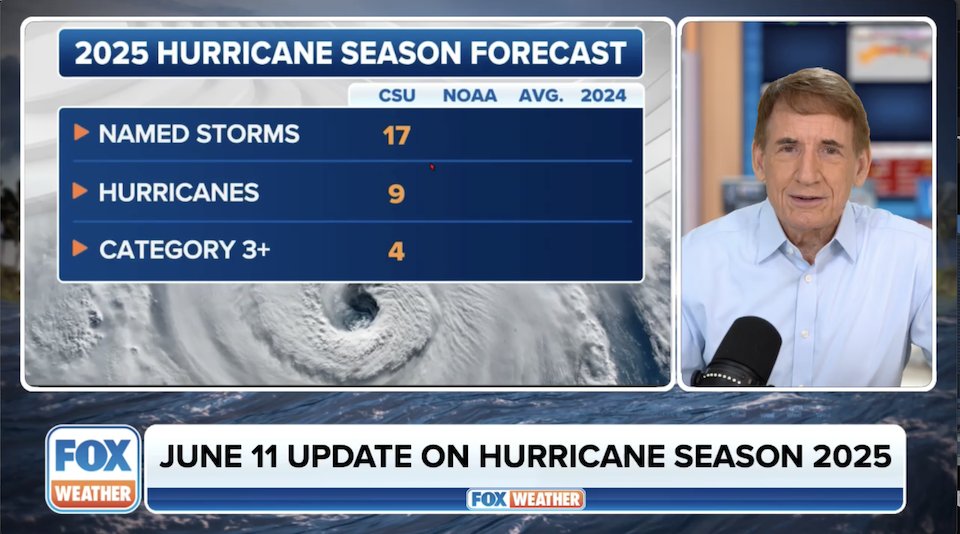
Atlantic seasonal #hurricane forecast update from Colorado State University continues call for an above-normal season: 17 named storms, 9 hurricanes & 4 major hurricanes. Relatively warm Atlantic and likely absence of #ElNino are the primary factors. tropical.colostate.edu/Forecast/2025-…

Atlantic seasonal #hurricane forecast update from <a href="/ColoradoStateU/">Colorado State University</a> continues call for an above-normal season: 17 named storms, 9 hurricanes &amp; 4 major hurricanes. Relatively warm Atlantic and likely absence of #ElNino are the primary factors.

tropical.colostate.edu/Forecast/2025-…
Bryan Norcross (@bryannorcrosstv) 's Twitter Profile Photo

VIDEO TROPICAL UPDATE on the updated hurricane season forecast from Colorado State plus the state of the season this point. youtu.be/ViVdhjJYDTU

VIDEO TROPICAL UPDATE on the updated hurricane season forecast from Colorado State plus the state of the season this point. youtu.be/ViVdhjJYDTU
Backpirch Weather (@backpirchcrew) 's Twitter Profile Photo

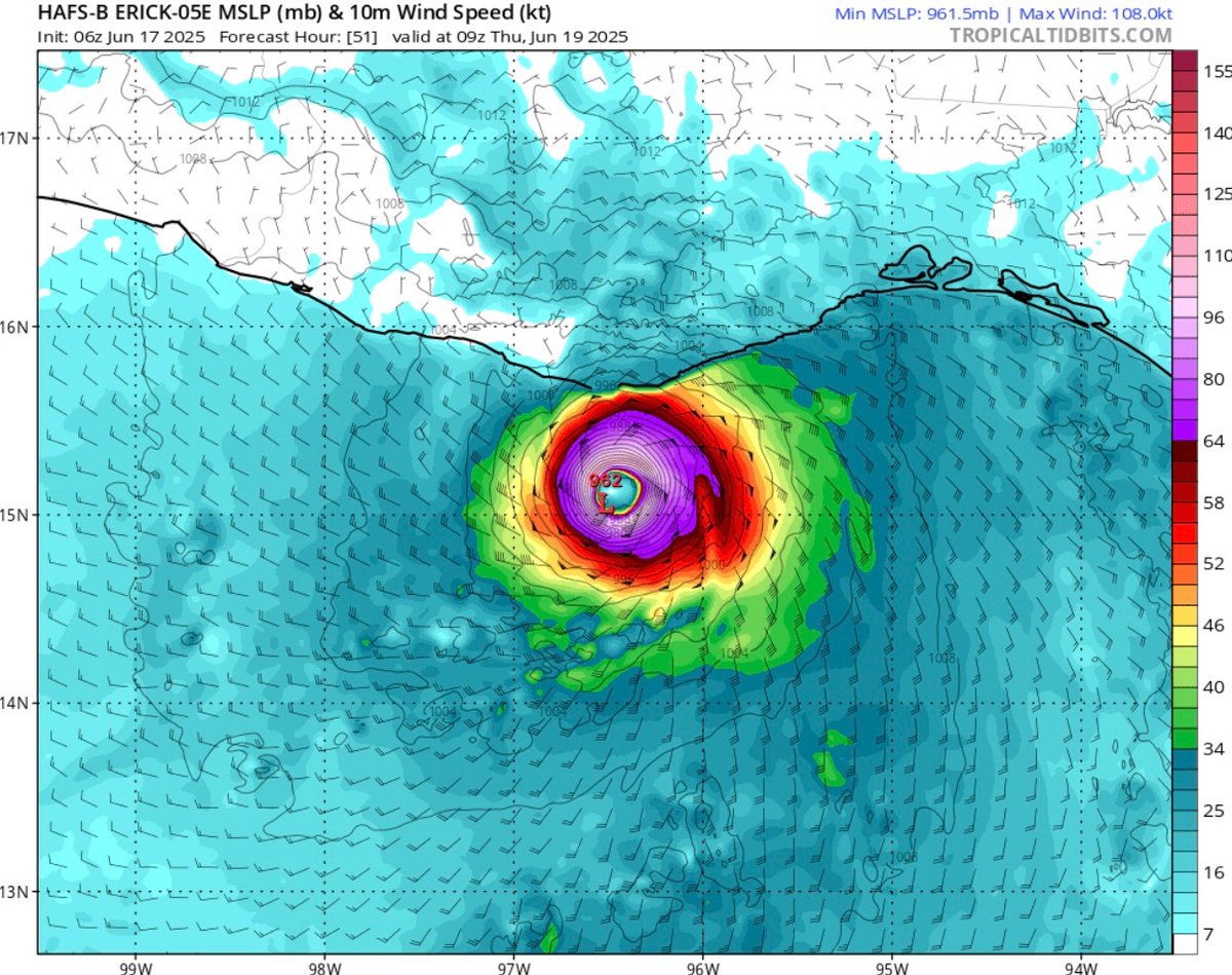
Three of the four primary Hurricane models are now forecasting #Erick to be a Major Hurricane at landfall. The latest NHC cone reflects this with a 110+ mph prediction for when the storm strikes Mexico. Rapid intensification is unfortunately looking more and more likely.

Three of the four primary Hurricane models are now forecasting #Erick to be a Major Hurricane at landfall. The latest NHC cone reflects this with a 110+ mph prediction for when the storm strikes Mexico. 

Rapid intensification is unfortunately looking more and more likely.
Danilo Evangelista (@daniloevan11) 's Twitter Profile Photo

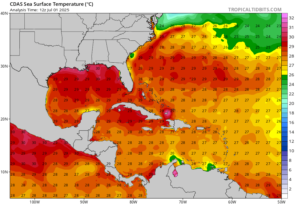
Whatever does develop will certainly have no problem drawing enough fuel for it to intensify. Water temps widespread at 29-30C across the northern gulf and off the SE coast of the US. 🔥🔥🔥🌀

Whatever does develop will certainly have no problem drawing enough fuel for it to intensify. Water temps widespread at 29-30C across the northern gulf and off the SE coast of the US. 🔥🔥🔥🌀
Paul Dellegatto⚡️FOX (@paulfox13) 's Twitter Profile Photo

Can you believe it's been 21 years since #Charley?? Hurricane Charley made landfall as a CAT 4 hurricane on this date in 2004 near Cayo Costa, FL. The same spot that Ian made landfall three years ago. Charley was one of FOUR hurricanes to hit Florida that year, others were

Weather Monitor (@weathermonitors) 's Twitter Profile Photo

BREAKING : Hurricane Erin Intensifies. By August 16, Erin has become a Category 5 hurricane with winds of 160 mph, ranking among the earliest and strongest Atlantic storms on record.

David Paul (@metdavidpaul) 's Twitter Profile Photo

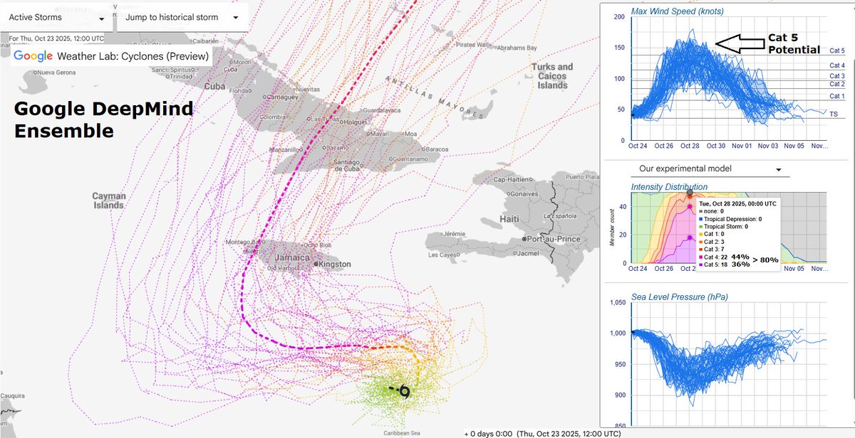
Latest Google DeepMind Ensemble here for TS Melissa. As shear relaxes this weekend, I'm expecting a period of rapid intensification. A whopping 80% of the members show Cat 4 or 5. Personally, I've been thinking Cat 5 all along by sometime Sunday/Monday. The eventual track, after

Latest Google DeepMind Ensemble here for TS Melissa. As shear relaxes this weekend, I'm expecting a period of rapid intensification. A whopping 80% of the members show Cat 4 or 5. Personally, I've been thinking Cat 5 all along by sometime Sunday/Monday. The eventual track, after
Backpirch Weather (@backpirchcrew) 's Twitter Profile Photo

Just as feared, Melissa is going absolutely nuclear S of Jamaica, with spine-chillingly cold convection sheathing the eyewall in deep, swirling drifts of thunderstorms. This is the type of stuff you normally see in the West Pacific. The type of stuff that monsters are born

Andy Hazelton (@andyhazelton) 's Twitter Profile Photo

Cool visualizations of our flights into Hurricane Melissa, with some comments from the crew members: reuters.com/graphics/STORM…