Esri (@esri) 's Twitter Profile
Esri

@esri

Esri builds #ArcGIS, the leading location intelligence and spatial analytics software for mapping, 3D GIS, imagery, and geospatial app development.

ID: 16132791

linkhttps://www.esri.com/ calendar_today04-09-2008 18:19:09

20,20K Tweet

194,194K Followers

69,69K Following

Overture Maps Foundation (@overturemaps) 's Twitter Profile Photo

By integrating GERS, Esri joined FEMA's USA Structures with Overture Buildings. This enabled detailed visualization of building occupancy and 3D representations, unlocking new use cases in thematic mapping and 3D analysis. Read the case study: hubs.ly/Q02GvKVJ0

By integrating GERS, <a href="/Esri/">Esri</a> joined FEMA's USA Structures with Overture Buildings. 

This enabled detailed visualization of building occupancy and 3D representations, unlocking new use cases in thematic mapping and 3D analysis. 

Read the case study: hubs.ly/Q02GvKVJ0
Esri (@esri) 's Twitter Profile Photo

Want to make art with ArcGIS? Learn how to make a woodcut print (or linocut), using ArcGIS Pro. Esri cartographer Heather Smith shows you how. esri.social/lgvT50SMo1m #ArcGISPro #Maps

Want to make art with ArcGIS? Learn how to make a woodcut print (or linocut), using ArcGIS Pro. Esri cartographer Heather Smith shows you how. esri.social/lgvT50SMo1m

#ArcGISPro #Maps
Esri (@esri) 's Twitter Profile Photo

Maps are powerful. They can spark curiosity, entertain, provide insight, and even drive people to take action that unites our world. Explore a gallery of inspiring maps. esri.social/GBQt50SOITh ⏰ π˜›π˜©π˜¦ 𝘞𝘰𝘳𝘭π˜₯ 𝘊𝘭𝘰𝘀𝘬, 𝘎𝘦𝘦 𝘍𝘦𝘳𝘯𝘒𝘯π˜₯𝘰 #Maps #EsriUC2024

Maps are powerful. They can spark curiosity, entertain, provide insight, and even drive people to take action that unites our world. Explore a gallery of inspiring maps. esri.social/GBQt50SOITh

⏰  π˜›π˜©π˜¦ 𝘞𝘰𝘳𝘭π˜₯ 𝘊𝘭𝘰𝘀𝘬, 𝘎𝘦𝘦 𝘍𝘦𝘳𝘯𝘒𝘯π˜₯𝘰

#Maps #EsriUC2024
ArcGIS StoryMaps (@arcgisstorymaps) 's Twitter Profile Photo

Approximately 570 million farms are scattered across the world's croplands and rangelands. How are those farms and commodities distributed? And what are their impacts? Explore #agriculture by the numbers, and beyond, in the August 2024 #StoryScape: esri.social/3Cof50SRei9

Esri (@esri) 's Twitter Profile Photo

Explore the application of spatial data science to uncover hidden patterns and improve predictive modeling. Join our free spatial data science MOOC starting August 28. πŸ”ΉRegister here: esri.social/Zj7B50SPGTU #DeepLearning #GIS Esri Training

Esri (@esri) 's Twitter Profile Photo

Did you know? πŸ€” The median age of Americans is at an all-time high. Updated age data gives new insight on the increase of the U.S. population older than 65+. esri.social/xbaF50SQetO #Demographics #Census

Did you know? πŸ€” The median age of Americans is at an all-time high. Updated age data gives new insight on the increase of the U.S. population older than 65+. esri.social/xbaF50SQetO

#Demographics #Census
Esri (@esri) 's Twitter Profile Photo

Give your maps some flair! ✨ Learn how to give your area of interest a peeled edge effect using ArcGIS Pro. esri.social/X3k450SQqHm #ArcGISPro #Cartography

Give your maps some flair! ✨ Learn how to give your area of interest a peeled edge effect using ArcGIS Pro. esri.social/X3k450SQqHm

#ArcGISPro #Cartography
Esri (@esri) 's Twitter Profile Photo

GIS Day is 100 days away! 🌎 Celebrate 25 years of this special day on November 20. Get all the details you need to plan your event here: esri.social/nBye50SUebW #GISDay

GIS Day is 100 days away! 🌎 Celebrate 25 years of this special day on November 20. Get all the details you need to plan your event here: esri.social/nBye50SUebW

#GISDay
Esri (@esri) 's Twitter Profile Photo

Explore the Great Barrier Reef, Papua New Guinea, and more with the Locators! 🌴Join them on an adventure in Oceania as they solve real-world problems using maps, technology, and spatial thinking. πŸ”ΈGet the book: esri.social/9Huu50STsVK #SpatialThinking #Geography Esri GIS Education

Explore the Great Barrier Reef, Papua New Guinea, and more with the Locators! 🌴Join them on an adventure in Oceania as they solve real-world problems using maps, technology, and spatial thinking.

πŸ”ΈGet the book: esri.social/9Huu50STsVK

#SpatialThinking #Geography <a href="/GISEd/">Esri GIS Education</a>
Esri (@esri) 's Twitter Profile Photo

Discover the unique world of endemic species! 🐾 From tiny caves to vast continents, these creatures are essential for maintaining biodiversity. esri.social/750l50SU48z #StoryMaps ArcGIS StoryMaps

Esri (@esri) 's Twitter Profile Photo

Discover how digital twin and 3D modeling technology reveals insights about life in the ancient city of Pompeii. Archaeologists Allison Emerson and Alex Elvis Badillo explain in the Esri & The Science of Where Podcast. 🎧 Listen: esri.social/jhYs50SU7j4 #DigitalTwin #Podcast

Discover how digital twin and 3D modeling technology reveals insights about life in the ancient city of Pompeii. Archaeologists Allison Emerson and Alex Elvis Badillo explain in the Esri &amp; The Science of Where Podcast.

🎧 Listen: esri.social/jhYs50SU7j4

#DigitalTwin #Podcast
Esri (@esri) 's Twitter Profile Photo

Join millions of scientists & naturalists worldwide in utilizing the powerful iNaturalist network to share detailed information about the biodiversity & species around them. 🌱 Now available in Beta within ArcGIS Living Atlas. esri.social/ZBiV50SZBlz #LivingAtlas #Biodiversity

Esri (@esri) 's Twitter Profile Photo

Love vintage maps? πŸ—ΊοΈ Create your own vintage-style basemap in ArcGIS Pro using layers from Living Atlas. esri.social/JZzc50T1iUA #ArcGISPro #LivingAtlas

Love vintage maps? πŸ—ΊοΈ Create your own vintage-style basemap in ArcGIS Pro using layers from Living Atlas. esri.social/JZzc50T1iUA

#ArcGISPro #LivingAtlas
Esri (@esri) 's Twitter Profile Photo

Explore a collection of beautiful 3D animated maps showcasing how The Power of Where can tackle the why, when, how, and who of many a major challenge - from finding the ideal place for a pet hotel to saving the world. 🌎 esri.social/B2Un50T2vtA #GIS #Maps

Explore a collection of beautiful 3D animated maps showcasing how The Power of Where can tackle the why, when, how, and who of many a major challenge - from finding the ideal place for a pet hotel to saving the world. 🌎 esri.social/B2Un50T2vtA

#GIS #Maps
Esri (@esri) 's Twitter Profile Photo

You don't need to be a superhero to have superpowers. πŸ¦ΈπŸ»β€β™€οΈ The Sentinel-1 Explorer lets you see Earth in incredible detail through clouds and wildfire smoke. So hang up your cape and let's get started. esri.social/SfpZ50T3qZO #Imagery #RemoteSensing

Esri (@esri) 's Twitter Profile Photo

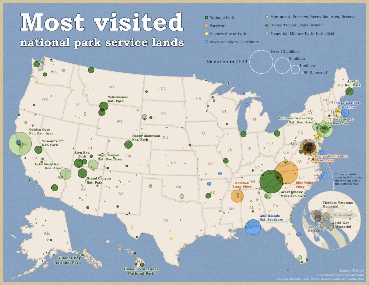
See how this map of National Park Service lands lets you visualize multiple variables at once. πŸ—ΊοΈ Very demure, very mindful. Learn how to use the new β€œquantity by category” capability in ArcGIS Pro. esri.social/Gn5J50T8Qsp #Cartocreativity #ArcGISPro

See how this map of <a href="/NatlParkService/">National Park Service</a> lands lets you visualize multiple variables at once. πŸ—ΊοΈ Very demure, very mindful. 

Learn how to use the new β€œquantity by category” capability in ArcGIS Pro. esri.social/Gn5J50T8Qsp

#Cartocreativity #ArcGISPro
Esri (@esri) 's Twitter Profile Photo

In Germany, the city of Stuttgart's Smart City Concept aims to improve urban planning with a cutting-edge 3D city model with help from GeoFly GmbH. esri.social/MIfw50T5jUt #3D #ArcGISReality πŸ”Έπ˜‹π˜ͺ𝘨π˜ͺ𝘡𝘒𝘭 𝘚𝘢𝘳𝘧𝘒𝘀𝘦 π˜”π˜°π˜₯𝘦𝘭 𝘧𝘰𝘳 𝘚𝘡𝘢𝘡𝘡𝘨𝘒𝘳𝘡⁠

In Germany, the city of Stuttgart's Smart City Concept aims to improve urban planning with a cutting-edge 3D city model with help from GeoFly GmbH. esri.social/MIfw50T5jUt

#3D #ArcGISReality

πŸ”Έπ˜‹π˜ͺ𝘨π˜ͺ𝘡𝘒𝘭 𝘚𝘢𝘳𝘧𝘒𝘀𝘦 π˜”π˜°π˜₯𝘦𝘭 𝘧𝘰𝘳 𝘚𝘡𝘢𝘡𝘡𝘨𝘒𝘳𝘡⁠
Esri (@esri) 's Twitter Profile Photo

Embark on a marvelous journey to the depths of the ocean with Dr. Dawn Wright + @deepseadawn.bsky.social πŸ‡ΊπŸ‡¦ to Challenger Deep, and learn the importance of ocean mapping. 🌊 Available now in paperback and ebook! ow.ly/UMuT50Tbeyq #ChallengerDeep #Mapping

Embark on a marvelous journey to the depths of the ocean with <a href="/deepseadawn/">Dr. Dawn Wright + @deepseadawn.bsky.social πŸ‡ΊπŸ‡¦</a> to Challenger Deep, and learn the importance of ocean mapping. 🌊 Available now in paperback and ebook! ow.ly/UMuT50Tbeyq

#ChallengerDeep #Mapping
ArcGIS StoryMaps (@arcgisstorymaps) 's Twitter Profile Photo

Are you an Esri Storyteller of the Year? Enter the 2024 ArcGIS #StoryMaps Competition to showcase your skills and innovative ideas for improving the world β€” from green cities to education to disaster response. Get started with a few simple tips: esri.social/anjc50TfNe2

Are you an <a href="/Esri/">Esri</a> Storyteller of the Year?

Enter the 2024 ArcGIS #StoryMaps Competition to showcase your skills and innovative ideas for improving the world β€” from green cities to education to disaster response.
 
Get started with a few simple tips: esri.social/anjc50TfNe2
Esri (@esri) 's Twitter Profile Photo

We are celebrating the work of Scripps Institution of Oceanography to understand coral reef ecology with the help of #ArcGISPro. πŸ”ΈRead more about their #100IslandChallenge here: esri.social/oyoJ50TgKQn