Chase Wilson (@dualdoppler) 's Twitter Profile
Chase Wilson

@dualdoppler

Meteorologist/Radar Analyst @tnvalleyweather • I have an X-band, and I’m not afraid to use it • Working to fill the TN Valley Radar Gap

ID: 1422656753209073670

linkhttp://tnvalleyweather.com calendar_today03-08-2021 20:33:01

3,3K Tweet

3,3K Followers

409 Following

Chase Wilson (@dualdoppler) 's Twitter Profile Photo

Every bit of a VIOLENT TORNADO moving towards Langdon and Plevna, KS this evening. We can only hope it dodges and weaves between these small towns

Every bit of a VIOLENT TORNADO moving towards Langdon and Plevna, KS this evening. We can only hope it dodges and weaves between these small towns
Chase Wilson (@dualdoppler) 's Twitter Profile Photo

Hard to say if it was a tornado or not (sure looked like one) but definitely at least an anticyclonic gustnado on COW2 just a few moments ago. Congrats on your first anticyclonic vortex hole, Doppler on Wheels (DOW) COW2! They grow up so fast.
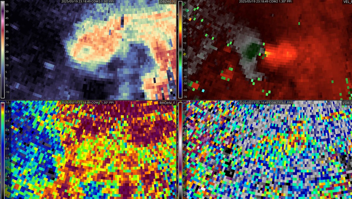
Hard to say if it was a tornado or not (sure looked like one) but definitely at least an anticyclonic gustnado on COW2 just a few moments ago. Congrats on your first anticyclonic vortex hole, <a href="/DOWFacility/">Doppler on Wheels (DOW)</a> COW2! They grow up so fast.
Chase Wilson (@dualdoppler) 's Twitter Profile Photo

On this day 12 years ago, the last EF-5 rated tornado impacted Moore, Oklahoma. Multiple nearby radars captured this tornado from start to end, including OU’s PX1000 mobile radar at very high spatiotemporal resolution (20 second samples at 30m resolution!) -

Chase Wilson (@dualdoppler) 's Twitter Profile Photo

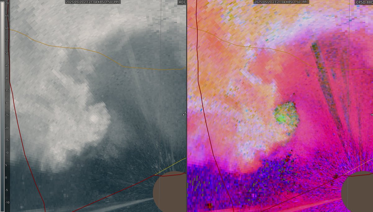
Monochrome reflectivity and dual-pol RGB where R = Zdr, G = dBz, B = CC from the UAH ARMOR Radar reveals the true structure of the significant tornado that prompted a tornado emergency earlier this evening in Madison, AL

Monochrome reflectivity and dual-pol RGB where R = Zdr, G = dBz, B = CC from the UAH ARMOR Radar reveals the true structure of the significant tornado that prompted a tornado emergency earlier this evening in Madison, AL
Chase Wilson (@dualdoppler) 's Twitter Profile Photo

Aerial views today from Tanner, AL and Killingsworth Cove Rd. Alabama, where several intense tornadoes touched down yesterday evening. Several areas of mass treefall and cycloidal markings are present amongst the damaged areas

Aerial views today from Tanner, AL and Killingsworth Cove Rd. Alabama, where several intense tornadoes touched down yesterday evening. Several areas of mass treefall and cycloidal markings are present amongst the damaged areas
Chase Wilson (@dualdoppler) 's Twitter Profile Photo

Some more aerial shots I got earlier this afternoon near Tanner, AL. That homeowner sure got lucky! Several intense subvortices were present in the greater circulation of the tornado, one of which here hit Reed Timmer, PhD

Some more aerial shots I got earlier this afternoon near Tanner, AL. That homeowner sure got lucky! Several intense subvortices were present in the greater circulation of the tornado, one of which here hit <a href="/ReedTimmerUSA/">Reed Timmer, PhD</a>
Chase Wilson (@dualdoppler) 's Twitter Profile Photo

Fresh satellite imagery from the last few days shows the massive scar across Daniel Boone National Forest from the EF4 tornado on May 16th, between Somerset and London, Kentucky as clear as day -

Fresh satellite imagery from the last few days shows the massive scar across Daniel Boone National Forest from the EF4 tornado on May 16th, between Somerset and London, Kentucky as clear as day -
Chase Wilson (@dualdoppler) 's Twitter Profile Photo

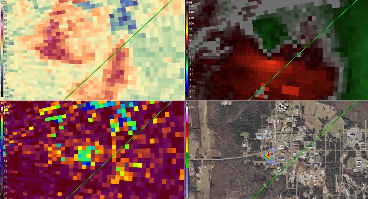
It would appear the ARMOR radar at Huntsville International Airport just captured a tornado on Redstone Arsenal, with a TDS at several points over the last 30 mins and couplet near the Missile Defense Agency buildings -

It would appear the ARMOR radar at Huntsville International Airport just captured a tornado on Redstone Arsenal, with a TDS at several points over the last 30 mins and couplet near the Missile Defense Agency buildings -
Chase Wilson (@dualdoppler) 's Twitter Profile Photo

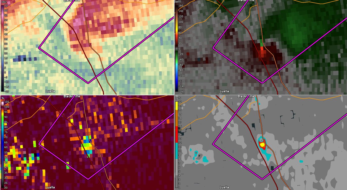
Robust - but certainly very tiny - supercell produced a tornado SE of Atlanta 15 mins ago, with a clear TDS and tight couplet nonetheless:

Robust - but certainly very tiny - supercell produced a tornado SE of Atlanta 15 mins ago, with a clear TDS and tight couplet nonetheless:
Chase Wilson (@dualdoppler) 's Twitter Profile Photo

Data continues to stream in from RaXPol from just west of Norman, Oklahoma - looks like they caught the tornado that occurred ~20 mins ago near Newcastle at close range

Data continues to stream in from RaXPol from just west of Norman, Oklahoma - looks like they caught the tornado that occurred ~20 mins ago near Newcastle at close range