DroneDeploy (@dronedeploy) 's Twitter Profile
DroneDeploy

@dronedeploy

All your photos, maps and models – from the air to the ground – in one place. #realitycapture

ID: 1407123218

linkhttps://bit.ly/3wGnY8X calendar_today06-05-2013 08:00:03

10,10K Tweet

34,34K Followers

762 Following

DroneDeploy (@dronedeploy) 's Twitter Profile Photo

DroneDeploy’s January 2025 update changes the game for RTK. 1️⃣ In-Flight RTK: RTK connections now happen after takeoff. 2️⃣ RTK Network Expansion: 8,000+ new base stations. Read the full product release: bit.ly/4ggSUBh #rtk #droneflight #dronemapping #accuracy

Suffolk Construction (@suffolkbuilds) 's Twitter Profile Photo

Innovative projects, like the Electric Central Utility Plant (eCUP) at DFW Airport, demand an innovative approach. Brad Brown, President of our TX region, and his team have applied more tech pilots to the project than any other Suffolk job in the country: linkedin.com/pulse/dfw-airp…

Innovative projects, like the Electric Central Utility Plant (eCUP) at <a href="/DFWAirport/">DFW Airport</a>, demand an innovative approach. Brad Brown, President of our TX region, and his team have applied more tech pilots to the project than any other Suffolk job in the country: linkedin.com/pulse/dfw-airp…
Cesium (@cesiumjs) 's Twitter Profile Photo

Siloed approaches to #AEC lead to delays and increased costs. DroneDeploy enables stakeholders to examine the entire life cycle of a project, using #3DTiles & Cesium ion Self-Hosted to make massive photogrammetry datasets manageable and accessible. hubs.li/Q0355pW30

DroneDeploy (@dronedeploy) 's Twitter Profile Photo

The Precon Manager’s Guide to Photo Documentation breaks down how to use aerial and ground reality capture to eliminate blind spots, win more bids and keep projects on track from day one. Download now: bit.ly/3EIeykZ #preconstruction #construction #ebook

DroneDeploy (@dronedeploy) 's Twitter Profile Photo

Your budget’s worst enemy? The unknown. DroneDeploy gives owners and precon teams a up-to-date, unbiased site view to prevent costly change orders and delays. Learn how to lock in cost certainty from day one ➡️ bit.ly/41ujy5H #preconstruction #tech

GEODNET (@geodnet_) 's Twitter Profile Photo

GEODNET Foundation and DroneDeploy have partnered to offer 10,000 RTK stations globally, bringing precision to drone-based surveying for construction, mining, and energy industries. With access to GEODNET's network, DroneDeploy users can now achieve centimeter-level accuracy

GEODNET Foundation and <a href="/DroneDeploy/">DroneDeploy</a> have partnered to offer 10,000 RTK stations globally, bringing precision to drone-based surveying for construction, mining, and energy industries.

With access to GEODNET's network, DroneDeploy users can now achieve centimeter-level accuracy
DroneDeploy (@dronedeploy) 's Twitter Profile Photo

Missed our DeployDay in Dallas, TX last week? Don't worry, we've got another one coming up in Phoenix, AZ at Andretti Indoor Karting and Games. Spots are filling up fast, save yours here: bit.ly/3DbxA2N #deploydays #events #construction #constructiontech

Missed our DeployDay in Dallas, TX last week? 

Don't worry, we've got another one coming up in Phoenix, AZ at Andretti Indoor Karting and Games. 

Spots are filling up fast, save yours here: bit.ly/3DbxA2N

#deploydays #events #construction #constructiontech
DroneDeploy (@dronedeploy) 's Twitter Profile Photo

The clock is ticking – Early Bird pricing for Horizons 2025 ends March 31! Save your spot: bit.ly/3DkCHxz #realitycapture #horizons2025 #drones #robotics #ai #techevents

DroneDeploy (@dronedeploy) 's Twitter Profile Photo

Spending hours on site walks to capture data with no context? DroneDeploy cuts your documentation time in half with integrated drone and 360 capture Learn how to start capturing: bit.ly/4fYRJGL #realitycapture #preconstruction #construction #constructiontech

Aydin Hutchison 🇦🇺🦘🐨 (@aydinskybrew) 's Twitter Profile Photo

Love using #DroneDeploy for point cloud mapping what about you? When flying jobs for my dad's company I tend to use DroneDeploy to setup maps & missions for #geological works. What’s your go-to software for mapping? Drop a reply! 👇 #drones #mapping

Energy Drone & Robotics Coalition (@enrgdrone) 's Twitter Profile Photo

These days, drones are doing the heavy lifting. This week’s article looks at how companies like DroneDeploy, ExxonMobil, ComEd, and others are using drones. 👀 Read the full story about the changing landscape of infrastructure inspections: hubs.la/Q03bknX-0

DroneDeploy (@dronedeploy) 's Twitter Profile Photo

Yet another successful DeployDay for the books - this time the team landed in Perth, Australia 🇦🇺 Want to check out a DeployDay for yourself? Register for our next one on March 26th in Phoenix, AZ: bit.ly/3DbxA2N #delpoyday #realitycapture #technology #techevents

Yet another successful DeployDay for the books - this time the team landed in Perth, Australia 🇦🇺 

Want to check out a DeployDay for yourself? Register for our next one on March 26th in Phoenix, AZ: bit.ly/3DbxA2N

#delpoyday #realitycapture #technology #techevents
DroneDeploy (@dronedeploy) 's Twitter Profile Photo

If you’re planning to attend Horizons 2025, now’s the time to grab a ticket. Early bird pricing ends March 31st. After that, ticket prices go up. Lock in your spot today: bit.ly/4i8jLRA #Horizons2025 #technology #techevents #drones #AI #innovation

If you’re planning to attend Horizons 2025, now’s the time to grab a ticket. 

Early bird pricing ends March 31st. After that, ticket prices go up. 

Lock in your spot today: bit.ly/4i8jLRA

#Horizons2025 #technology #techevents #drones #AI #innovation
DroneDeploy (@dronedeploy) 's Twitter Profile Photo

Remote oversight isn't a nice-to-have. It's a competitive edge. Skanska USA is cutting the wasted miles and miscommunication by using DroneDeploy’s 360 captures to confirm jobsite readiness – remotely: bit.ly/4c3eoRB #construction #constructiontech

Mapbox (@mapbox) 's Twitter Profile Photo

DroneDeploy is a global leader in reality capture, providing innovative mapping and site documentation tools using drones, robotics, 360 cameras, and 3D LiDAR. Industries from construction to agriculture rely on DroneDeploy to analyze data, streamline operations, and make
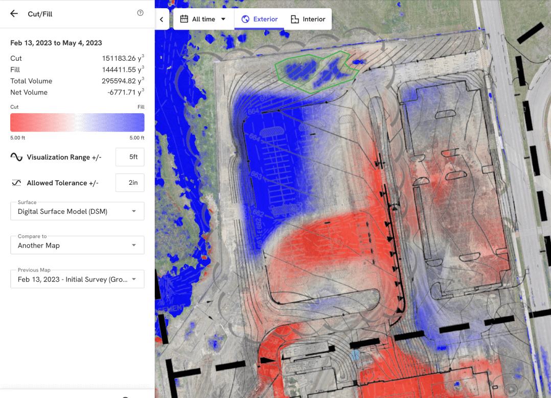
<a href="/DroneDeploy/">DroneDeploy</a> is a global leader in reality capture, providing innovative mapping and site documentation tools using drones, robotics, 360 cameras, and 3D LiDAR. Industries from construction to agriculture rely on DroneDeploy to analyze data, streamline operations, and make
Energy Drone & Robotics Coalition (@enrgdrone) 's Twitter Profile Photo

See DroneDeploy at Booth 711 during #EDRS2025. Explore automated asset inspections with DJI Dock 2 & 3, ground robots & 360 cameras—all powered by their Unified Reality Capture Platform. 📍 Register now! hubs.la/Q03n42Mv0 #DroneDeploy #RealityCapture #UAV #AssetInspection

See <a href="/DroneDeploy/">DroneDeploy</a> at Booth 711 during #EDRS2025. Explore automated asset inspections with DJI Dock 2 &amp; 3, ground robots &amp; 360 cameras—all powered by their Unified Reality Capture Platform.
📍 Register now! hubs.la/Q03n42Mv0
#DroneDeploy #RealityCapture #UAV #AssetInspection