CopPhil (@copphil) 's Twitter Profile
CopPhil

@copphil

The #CopPhil Centre is an initiative funded by the @EU_Commission and is implemented by @esa, in partnership with @PhilSpaceAgency and @DOSTphl

#GlobalGateway

ID: 1829549544071122944

linkhttps://linktr.ee/copphilcentre calendar_today30-08-2024 16:00:38

56 Tweet

32 Takipçi

42 Takip Edilen

EU Civil Protection & Humanitarian Aid 🇪🇺 (@eu_echo) 's Twitter Profile Photo

Typhoon Trami has claimed at least 85 lives and caused widespread destruction in the Philippines. EU humanitarian aid teams are on the ground to assess the needs and help deliver emergency assistance. Our thoughts go out to all those affected by the storm. #KristinePH

Typhoon Trami has claimed at least 85 lives and caused widespread destruction in the Philippines.

EU humanitarian aid teams are on the ground to assess the needs and help deliver emergency assistance.

Our thoughts go out to all those affected by the storm.

#KristinePH
Women+ in Geospatial (@geospatialwomen) 's Twitter Profile Photo

Explore Jobs, Grants & Scholarships, PhDs & Post-docs, Trainee & Entry-Level Positions, Internships & Fellowships, Events & Courses in our latest edition of Women+ in Geospatial Rising– everything you need to kick-start your career in #geospatial. 👇 linkedin.com/posts/women-in…

Explore Jobs, Grants & Scholarships, PhDs & Post-docs, Trainee & Entry-Level Positions, Internships & Fellowships, Events & Courses in our latest edition of Women+ in Geospatial Rising– everything you need to kick-start your career in #geospatial.
👇
linkedin.com/posts/women-in…
Disasters Charter (@disasterschart) 's Twitter Profile Photo

These maps use data from #Sentinel1, #Sentinel2, and the #RCmSatellites to estimate the extent of flooding in the Bicol region after #TyphoonTrami: bit.ly/4hlaq98 #KristinePH

These maps use data from #Sentinel1, #Sentinel2, and the #RCmSatellites to estimate the extent of flooding in the Bicol region after #TyphoonTrami: bit.ly/4hlaq98
#KristinePH
UNDRR (@undrr) 's Twitter Profile Photo

What is the impact of human presence on #flooding? Changes in hydrological processes & extreme events are connected with human actions altering river basins globally. This report explores related impact of urbanisation trends: 👉ow.ly/7zAN50TYhIP #NoNaturalDisasters

UNDRR (@undrr) 's Twitter Profile Photo

📈 Increasing economic inequality is significantly influencing countries' vulnerability to natural hazards. This study from NatureSustainability analyses income inequality and flood disasters in 67 middle- and high-income countries over 18 years. ➡️ ow.ly/BaFc50SAsQT
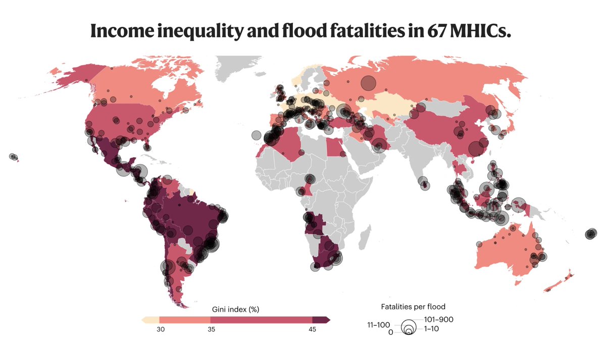
📈 Increasing economic inequality is significantly influencing countries' vulnerability to natural hazards. 

This study from <a href="/naturesustainab/">NatureSustainability</a> analyses income inequality and flood disasters in 67 middle- and high-income countries over 18 years.  ➡️ ow.ly/BaFc50SAsQT
Copernicus EU (@copernicuseu) 's Twitter Profile Photo

The Del Carmen Mangrove Reserve on Siargao Island in the 🇵🇭, visible in this #Sentinel2 image, was designated a Ramsar Site of International Importance. Spanning nearly 4,900 hectares, the reserve forms the country's largest contiguous mangrove forest. copernicus.eu/en/media/image…

The Del Carmen Mangrove Reserve on Siargao Island in the 🇵🇭, visible in this #Sentinel2 image, was designated a Ramsar Site of International Importance. 

Spanning nearly 4,900 hectares, the reserve forms the country's largest contiguous mangrove forest.

copernicus.eu/en/media/image…
Copernicus EMS (@copernicusems) 's Twitter Profile Photo

#DYK that over 80% of #Manila 🇵🇭 residents live in one- or two-story buildings❓ ➡️This makes them highly vulnerable to coastal #flooding 🌊 Our #GHSL🧑‍🤝‍🧑🛰️ Urban Centre Database provides key insights to support disaster preparedness Read more at👇 arcgis.jrc.ec.europa.eu/portal/apps/st…

#DYK that over 80% of #Manila 🇵🇭 residents live in one- or two-story buildings❓

➡️This makes them highly vulnerable to coastal #flooding 🌊

Our #GHSL🧑‍🤝‍🧑🛰️ Urban Centre Database provides key insights to support disaster preparedness

Read more at👇
arcgis.jrc.ec.europa.eu/portal/apps/st…
Philippine Space Agency (@philspaceagency) 's Twitter Profile Photo

IN PHOTOS: Training Course on Downstream Data Utilization 💻 The Philippine Space Agency (PhilSA) successfully completed its Training Course on Downstream Data Utilization for educators, researchers, and professionals from 25 to 29 November 2024 in Quezon City.

IN PHOTOS: Training Course on Downstream Data Utilization 💻

The Philippine Space Agency (PhilSA) successfully completed its Training Course on Downstream Data Utilization for educators, researchers, and professionals from 25 to 29 November 2024 in Quezon City.
CopPhil (@copphil) 's Twitter Profile Photo

🌏The 🇪🇺 #GlobalGateway CopPhil programme joined Ateneo de Manila University students to discuss using #EarthObservation for disaster risk reduction #DRR! 🛰️From satellite data to space governance, students explored how #Copernicus transforms DRR in 🇵🇭 Read more: copphil.philsa.gov.ph/news/copphil-t…
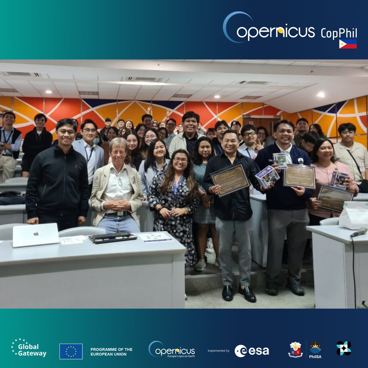
🌏The 🇪🇺 #GlobalGateway CopPhil programme joined <a href="/ateneodemanilau/">Ateneo de Manila University</a> students to discuss using #EarthObservation for disaster risk reduction #DRR!

🛰️From satellite data to space governance, students explored how #Copernicus transforms DRR in 🇵🇭

Read more: copphil.philsa.gov.ph/news/copphil-t…
CopPhil (@copphil) 's Twitter Profile Photo

#DYK that last week’s launch of #Copernicus #Sentinel1C will bring several benefits to the #Philippines 🇵🇭? Learn more about local applications of #Sentinel1 data and our related pilot services and activities 👇 Bit.ly/4g4ROt0 #GlobalGateway

#DYK that last week’s launch of #Copernicus #Sentinel1C will bring several benefits to the #Philippines 🇵🇭?

Learn more about local applications of #Sentinel1 data and our related pilot services and activities 👇
Bit.ly/4g4ROt0

#GlobalGateway
CopPhil (@copphil) 's Twitter Profile Photo

Earlier this month, the #CopPhil Technical Assistance joined the Humanitarian OpenStreetMap Team Telemapathon to discuss how Copernicus EU data🛰️ informs multi-hazard risk assessments, building disaster resilience in the #Philippines 🇵🇭 Read more👇 copphil.philsa.gov.ph/news/copphil-t… #GlobalGateway #OpenStreetMap

Earlier this month, the #CopPhil Technical Assistance joined the <a href="/hotosm/">Humanitarian OpenStreetMap Team</a> Telemapathon to discuss how <a href="/CopernicusEU/">Copernicus EU</a> data🛰️ informs multi-hazard risk assessments, building disaster resilience in the #Philippines 🇵🇭

Read more👇
copphil.philsa.gov.ph/news/copphil-t…

#GlobalGateway #OpenStreetMap
UN Biodiversity (@unbiodiversity) 's Twitter Profile Photo

🌿 Nature-based solutions are attracting ever more interest as a way to reduce disaster risks while providing environmental and economic benefits. 🌎 Explore further ➡️ ow.ly/ROno50UnC9G #NatureBasedSolutions via UNDRR

🌿 Nature-based solutions are attracting ever more interest as a way to reduce disaster risks while providing environmental and economic benefits. 🌎

Explore further ➡️ ow.ly/ROno50UnC9G 
#NatureBasedSolutions 

via <a href="/UNDRR/">UNDRR</a>
CopPhil (@copphil) 's Twitter Profile Photo

📢 CopPhil is now on Facebook! Stay up to date on our activities and events by joining the community: facebook.com/copphil/ And don’t forget to follow us on LinkedIn!👇 linkedin.com/company/copphi… #GlobalGateway

📢 CopPhil is now on Facebook!

Stay up to date on our activities and events by joining the community: facebook.com/copphil/

And don’t forget to follow us on LinkedIn!👇 linkedin.com/company/copphi…

#GlobalGateway
Copernicus Marine (@cmems_eu) 's Twitter Profile Photo

Discover the #EUDigitalOceanPavilion at #UNOC3❗️ 🪸Dive into an immersive experience in the ENGAGE Area 🌊Explore the #EUDTO in the DECIDE Area 🎙️Hear from leading experts in the INSPIRE Area 3 areas to learn about #OurOcean & the impact & progress of marine science