Convective Chronicles
@convchronicles
One-stop shop for in-depth forecast discussions and case studies for upcoming and past severe weather events across the United States.
ID: 1511478794632286230
https://www.youtube.com/ConvectiveChronicles 05-04-2022 23:00:11
4,4K Tweet
10,10K Followers
781 Following
 's Twitter Profile Photo")
Not all satellite bands are created equal. ⚡ Band 2: visible red → sharpest detail 🌡️ IR: colder tops = stronger storms 💧 Water vapor: track troughs & ridges Convective Chronicles breaks down how to actually use them in the field. 🎬 Link in replies!
 on Twitter photo Not all satellite bands are created equal.
⚡ Band 2: visible red → sharpest detail
🌡️ IR: colder tops = stronger storms
💧 Water vapor: track troughs & ridges
<a href=\"/ConvChronicles/\">Convective Chronicles</a> breaks down how to actually use them in the field.
🎬 Link in replies!")
 on Twitter photo Supercells likely this afternoon/evening from SW KS to TX Panhandle, where SPC outlines Slight Risk (level 2/5). Convergence along differential heating zone should lead to storm initiation by late afternoon; very large hail main threat, w/ low-end damaging wind/brief tornado risk")
 on Twitter photo Tornado north of Laverne, OK a few mins ago. #okwx")
 on Twitter photo Awesome structure on the tornado-warned supercell east of Follett, TX, as the sun was setting this evening. #txwx #okwx")
 on Twitter photo LINK: youtube.com/watch?v=JWs26O…
In-depth meteorological breakdown of the March 14, 2025, prolific tornado outbreak from the Midwest to the Southeast. We'll discuss the incredible synoptics behind this event and some additional reasons why this was such a high-end outbreak.")
 on Twitter photo Strong to severe storms are expected from eastern Colorado into the Oklahoma/Texas Panhandles this afternoon and evening, where SPC has outlined a Slight Risk (level 2/5). The main threat will be large to very large hail and perhaps isolated damaging wind gusts.")
 on Twitter photo Today is the statistical peak of the Atlantic hurricane season, yet we have no storms or even areas of interest to track! This is due to a background pattern that's been quite hostile for developing waves, despite warm sea-surface temperatures & low wind shear in the Caribbean.")
In episode 7 of Chase & Explain, Aaron Jayjack Jack shows how: ✅ Early Kansas storms delivered wedges ✅ Oklahoma’s tornado-driven MOD risk busted ✅ Why multiple chase days matter 🎬 Full breakdown inside the Chaser Academy. Link in profile
 on Twitter photo The Chaser Academy now has:
✅ 6 full training modules
✅ Dozens of real-chase breakdowns
✅ Q&A sessions with pro chasers
✅ New content dropping monthly
All for just $19/month.
🎓 Learn smarter. Chase better.
➡️ Join now! Link in profile!")
 on Twitter photo NHC has identified an area to watch in Atlantic. Wave expected to emerge off African coast tomorrow; atmospheric conditions may be favorable enough for this system to develop. Only 30% chance within 7 days per NHC, but good model support for some kind of tropical development.")
📡 Radar gets the glory, but satellite gives the early signals. Convective Chronicles breaks it down: ☑️ Visible imagery for storm features ☑️ Infrared for storm intensity ☑️ Water vapor for upper-level dynamics Watch now–link in replies!
 on Twitter photo 📡 Radar gets the glory, but satellite gives the early signals.
<a href=\"/ConvChronicles/\">Convective Chronicles</a> breaks it down:
☑️ Visible imagery for storm features
☑️ Infrared for storm intensity
☑️ Water vapor for upper-level dynamics
Watch now–link in replies!")
🛰️ New podcast episode! Want sharper chase targets? Convective Chronicles teaches you how to: ⚡ Spot horizontal convective rolls (cloud streets) 🌡️ Use IR to pick the strongest storms ☁️ Identify above-anvil cirrus plumes 🎧 Listen now–link in replies!
 on Twitter photo 🛰️ New podcast episode!
Want sharper chase targets? <a href=\"/ConvChronicles/\">Convective Chronicles</a> teaches you how to:
⚡ Spot horizontal convective rolls (cloud streets)
🌡️ Use IR to pick the strongest storms
☁️ Identify above-anvil cirrus plumes
🎧 Listen now–link in replies!")
 on Twitter photo Severe storms, incl supercells, ongoing in E UT/W CO this AM as deep trough rolls in. This is Southwest \"transition season,\" when remnant monsoon moisture interacts w/ strong Pacific troughs, yielding regionally robust severe wx. Today, hail/wind main risks E UT/W CO to E AZ/W NM")
Satellite isn’t just pretty pictures—it’s a forecasting weapon. In this episode Convective Chronicles breaks down: 🌪️ Cloud streets & lingering stability 📊 IR imagery for storm intensity ☁️ Above-anvil plumes = powerhouse storms 🎙️ Listen now! Links in replies!
 on Twitter photo Satellite isn’t just pretty pictures—it’s a forecasting weapon.
In this episode <a href=\"/ConvChronicles/\">Convective Chronicles</a> breaks down:
🌪️ Cloud streets & lingering stability
📊 IR imagery for storm intensity
☁️ Above-anvil plumes = powerhouse storms
🎙️ Listen now! Links in replies!")
 's Twitter Profile Photo")
 on Twitter photo Three additional shots from the tornado in San Juan County Utah today! Source is unknown but posted by Daniel Woodruff on FB #utwx")
 on Twitter photo Severe storms expected along cold front over large expanse of the Plains today. The most intense activity should focus ahead of surface low across ND, where highest tornado threat exists, & along NE/KS border, where steeper lapse rates aloft may yield greater large hail potential")
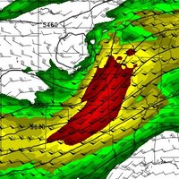
 on Twitter photo An additional area of heightened severe potential has been added across southwest Kansas/northwest Oklahoma into the northeast Texas Panhandle by the SPC with their latest update. Here, severe storms with a large hail and damaging wind threat are possible this afternoon/evening.")