Betty Davis(@BettyDavisWPLG) 's Twitter Profileg
Betty Davis

@BettyDavisWPLG

Chief Meteorologist at WPLG-TV in Miami

ID:1032700918247174144

calendar_today23-08-2018 18:47:40

2,1K Tweets

2,8K Followers

1,2K Following

Betty Davis(@BettyDavisWPLG) 's Twitter Profile Photo

South FL’s weather will be nice & warm this weekend. Let’s get out & do something fun! Join me for a great community event— Sunday, April 21– GOSPELFEST at Little Haiti Cultural Center . Get your free ticket arshtcenter.org/best-available…

South FL’s weather will be nice & warm this weekend. Let’s get out & do something fun! Join me for a great community event— Sunday, April 21– GOSPELFEST at Little Haiti Cultural Center #Miami. Get your free ticket arshtcenter.org/best-available…
account_circle
Justin Rosenberg(@JustinR56195283) 's Twitter Profile Photo

Betty Davis: Good Evening Betty. Yeah I want to share this Beautiful Picture Of Today's Solar Eclipse which I took from The Promanade Mall in The City Of Coconut Creek.
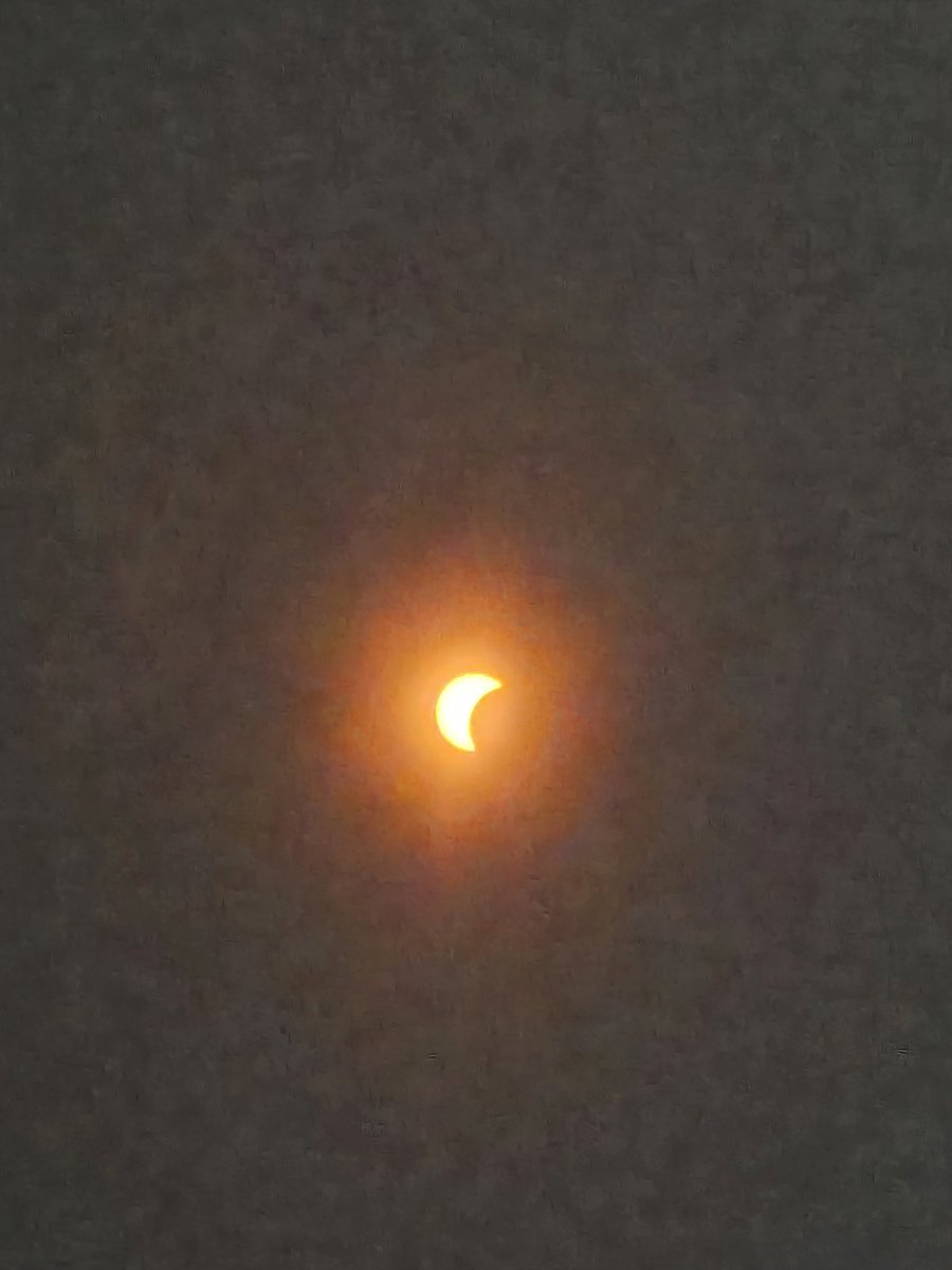
@BettyDavisWPLG: Good Evening Betty. Yeah I want to share this Beautiful Picture Of Today's Solar Eclipse which I took from The Promanade Mall in The City Of Coconut Creek.
account_circle
Betty Davis(@BettyDavisWPLG) 's Twitter Profile Photo

Winter ends with a sizzle for South Florida! March 18, 2024 is one for the record books. Miami and Fort Lauderdale set new record high temperatures for the date!

account_circle
Betty Davis(@BettyDavisWPLG) 's Twitter Profile Photo

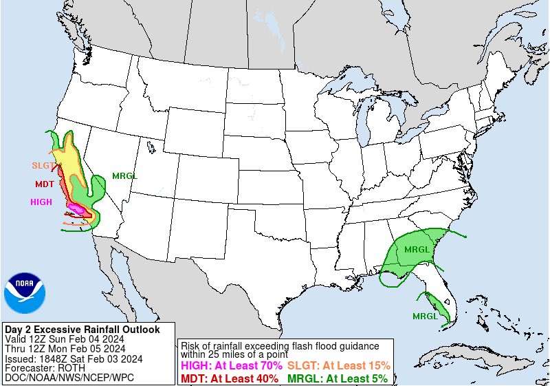
⛈️⛈️While California preps for heavy rain & potentially life-threatening flash flooding, South FL is set to break its dry streak. Rain returns Sunday- CAN’T RULE OUT STRONG TO SEVERE STORMS! Main threat: damaging wind or tornado. MIA’s last measurable rain on 1/22, FLL 1/14.

⛈️⛈️While California preps for heavy rain & potentially life-threatening flash flooding, South FL is set to break its dry streak. Rain returns Sunday- CAN’T RULE OUT STRONG TO SEVERE STORMS! Main threat: damaging wind or tornado. MIA’s last measurable rain on 1/22, FLL 1/14.
account_circle
Betty Davis(@BettyDavisWPLG) 's Twitter Profile Photo

TOASTY TO CHILLY-- The last weekend of January 2024 will be warm for South Florida. Then, get ready to 'chill' after a cold front sweeps the region Sunday night. Brace for low temperatures in the 50s next week! Dade

account_circle
Betty Davis(@BettyDavisWPLG) 's Twitter Profile Photo

Tuesday will be windy! Plus, there is severe weather potential for Florida, including a marginal risk for , , & the Keys. Main threats: damaging wind gusts & tornadoes. It appears a line of storms will reach the area Tuesday night.

account_circle
Betty Davis(@BettyDavisWPLG) 's Twitter Profile Photo

🌪️ NWS Miami storm survey expected on Sunday in Fort Lauderdale- Las Olas Blvd. area. Here’s another video of the tornado (captured just before 6pm Saturday) — with a brief play-by-play— from one observer.
🎥Teri Goldsmith

account_circle
Betty Davis(@BettyDavisWPLG) 's Twitter Profile Photo

The first weekend of 2024 brings a bevy of changes for South Florida. Saturday: Warm, breezy with a round of gusty rain. Showers/storms will be monitored for damaging wind gusts or a brief tornado. Sunday: Turning cooler with a dreary vibe.

account_circle
Betty Davis(@BettyDavisWPLG) 's Twitter Profile Photo

A storm system will move eastward across the U.S. this Christmas weekend. It appears South Florida will remain outside the main rain event associated with the 'weather maker' through Christmas day. Temps will be near seasonable.

account_circle
Betty Davis(@BettyDavisWPLG) 's Twitter Profile Photo

FLOOD WATCH— coastal/metro Flooding possible from bouts of heavy rain Wednesday through Thursday morning.
How much forecast? 2 to 5”.. some spots may top 7” Get updates here local10.com/weather/
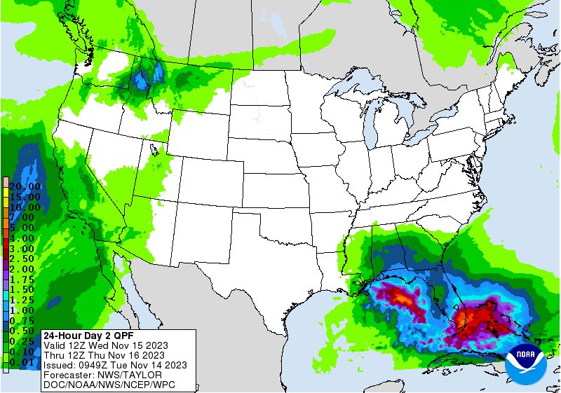
FLOOD WATCH— coastal/metro #MiamiDade #Broward #PalmBeach Flooding possible from bouts of heavy rain Wednesday through Thursday morning. How much forecast? 2 to 5”.. some spots may top 7” Get updates here local10.com/weather/
account_circle
Betty Davis(@BettyDavisWPLG) 's Twitter Profile Photo

REFRESH, ANYONE? -- After a hot end to October (Miami hit 90°F on Halloween), South Florida gets a refresh to start November! NNE breezes build & bring relatively cooler conditions to Miami-Dade/Broward. Marine conditions will deteriorate.

account_circle
Betty Davis(@BettyDavisWPLG) 's Twitter Profile Photo

Almost time & it’s FREE! Celebrate the 15th anniversary of Free Gospel Sundays at the Arsht Center with me & my cohost Calvin Hughes Starring Tasha Page-Lockhart live on OCT 29th at 5pm. First-access passes are FREE and available now at arshtcenter.org. Arsht Center

Almost time & it’s FREE! Celebrate the 15th anniversary of Free Gospel Sundays at the Arsht Center with me & my cohost @CalvinWPLG Starring Tasha Page-Lockhart live on OCT 29th at 5pm. First-access passes are FREE and available now at arshtcenter.org. @ArshtCenter #Miami
account_circle
Betty Davis(@BettyDavisWPLG) 's Twitter Profile Photo

WAIT FOR IT-- A cold front appears to have its sights set on South Florida! Until it clears, plan for high temperatures in the 90s in for the rest of the week. Records could fall! Refreshing lows in the 60s will be appreciated next week.

account_circle
Betty Davis(@BettyDavisWPLG) 's Twitter Profile Photo

DRY SEASON VIBES-- Less rain, ample sun is the trend for the rest of the week for South Florida. Low rain chances are apropos, considering the fixed calendar end date for rainy season is October 15th. Dade

account_circle
Betty Davis(@BettyDavisWPLG) 's Twitter Profile Photo

SEPTEMBER SHOWERS-- A stormier weather pattern is ahead for South Florida as a stalled front lingers over the sunshine state. Dade

account_circle