ArcGIS Urban (@arcgisurban) 's Twitter Profile
ArcGIS Urban

@arcgisurban

ArcGIS Urban is a web-based 3D planning experience that enables communities to make smart decisions for urban development. #UrbanPlanning #3D #SmartCities

ID: 1005147442470273024

linkhttps://www.esri.com/en-us/arcgis/products/arcgis-urban/overview calendar_today08-06-2018 17:59:59

453 Tweet

1,1K Followers

38 Following

ArcGIS Urban (@arcgisurban) 's Twitter Profile Photo

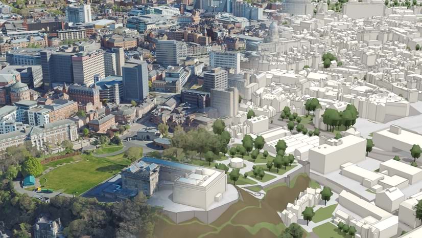
Nottingham, UK uses #ArcGISUrban to evaluate development proposals—dropping buildings into a digital twin to assess visual impact, site capacity, and negotiate height and floor space. 🏙️📐 #ArcGISUrban #DigitalTwin #UrbanPlanning 🔗 ow.ly/lP6r50W1xQM

Nottingham, UK uses #ArcGISUrban to evaluate development proposals—dropping buildings into a digital twin to assess visual impact, site capacity, and negotiate height and floor space. 🏙️📐
#ArcGISUrban #DigitalTwin #UrbanPlanning
🔗 ow.ly/lP6r50W1xQM
ArcGIS Urban (@arcgisurban) 's Twitter Profile Photo

Urban forests are increasingly becoming recognized as infrastructure, deserving the same critical attention as other vital investments. Geospatial planning tools are crucial resources for urban planners to organize and guide preservation efforts. ow.ly/9X8r50W2AZw

Urban forests are increasingly becoming recognized as infrastructure, deserving the same critical attention as other vital investments. Geospatial planning tools are crucial resources for urban planners to organize and guide preservation efforts. ow.ly/9X8r50W2AZw
ArcGIS Urban (@arcgisurban) 's Twitter Profile Photo

In the new Reinventing Planning podcast,we sit down with Jason Jordan, Principal for Public Affairs at the APA to explore how federal decisions shape local and regional planning efforts. ow.ly/pM3930sN7PX

In the new Reinventing Planning podcast,we sit down with Jason Jordan, Principal for Public Affairs at the APA to explore how federal decisions shape local and regional planning efforts. ow.ly/pM3930sN7PX
ArcGIS Urban (@arcgisurban) 's Twitter Profile Photo

#UC2025 is just around the corner! Be sure to check out the Community Development showcase and explore the recommended sessions, available for both in-person and virtual attendance. ow.ly/hZIP50WlXTo

#UC2025 is just around the corner! Be sure to check out the Community Development showcase and explore the recommended sessions, available for both in-person and virtual attendance. ow.ly/hZIP50WlXTo
ArcGIS Urban (@arcgisurban) 's Twitter Profile Photo

🚀 New in #ArcGISUrban (July 2025)! – Add 2D site plan blueprints directly to scenarios – Set default scenarios to highlight active proposals – Copy metrics between plans + save analyses with new analysis mode Full update: ow.ly/olb250WvvYe

🚀 New in #ArcGISUrban (July 2025)!
– Add 2D site plan blueprints directly to scenarios
– Set default scenarios to highlight active proposals
– Copy metrics between plans + save analyses with new analysis mode
Full update: ow.ly/olb250WvvYe
ArcGIS Urban (@arcgisurban) 's Twitter Profile Photo

Urban XR has evolved. Introducing XR Viewer: a new beta that takes what we started with Urban XR and pushes it further, bringing Urban models and web scenes into fully immersive extended reality. Watch the UC plenary clip to see it in action! ow.ly/MEmS50Wxng0

Urban XR has evolved. Introducing XR Viewer: a new beta that takes what we started with Urban XR and pushes it further, bringing Urban models and web scenes into fully immersive extended reality. Watch the UC plenary clip to see it in action! ow.ly/MEmS50Wxng0
ArcGIS Urban (@arcgisurban) 's Twitter Profile Photo

Did you know you can go from concept to detailed 3D, all in one workflow, with ArcGIS Urban and CityEngine? Start with early-stage massing, add realistic building facades and streets in CityEngine, and bring it back to Urban to see it in full city context. ow.ly/eSXH50Wxnlj

ArcGIS Urban (@arcgisurban) 's Twitter Profile Photo

#ArcGISEnterprise unveiled updates for scalability, security, and decision-making at #EsriUC2025. Highlights include immersive XR, real-time data, new beta features, and more. Check out the full list and start transforming your workflows today! Read now ➡️ow.ly/4AcI30sOYQz

#ArcGISEnterprise unveiled updates for scalability, security, and decision-making at #EsriUC2025. Highlights include immersive XR, real-time data, new beta features, and more. Check out the full list and start transforming your workflows today!

Read now ➡️ow.ly/4AcI30sOYQz
ArcGIS Urban (@arcgisurban) 's Twitter Profile Photo

Nottingham uses a 3D digital twin to transform urban planning. 🏙️ Planners drop proposed buildings into a virtual model to test visual impact, site capacity & negotiate height/space. The result? Faster approvals, better design, & more public transparency. ow.ly/TGgP50WIR75

Nottingham uses a 3D digital twin to transform urban planning. 🏙️ Planners drop proposed buildings into a virtual model to test visual impact, site capacity & negotiate height/space. The result? Faster approvals, better design, & more public transparency. ow.ly/TGgP50WIR75
ArcGIS Urban (@arcgisurban) 's Twitter Profile Photo

See how proposals fit into the bigger picture. 🌆 By setting and viewing project scenarios in both city overviews and plan views, planners get full context for smarter decisions, faster approvals, and clearer communication. ow.ly/FVj350WISzI

ArcGIS Urban (@arcgisurban) 's Twitter Profile Photo

The 2025 Planning Directors Summit is now open for registration! Join your peers in West Palm Beach, Florida, to talk housing, economic mobility, comprehensive planning, and more. Request to attend here: ow.ly/FfyJ30sP7WS

The 2025 Planning Directors Summit is now open for registration! Join your peers in West Palm Beach, Florida, to talk housing, economic mobility, comprehensive planning, and more. Request to attend here: ow.ly/FfyJ30sP7WS
ArcGIS Urban (@arcgisurban) 's Twitter Profile Photo

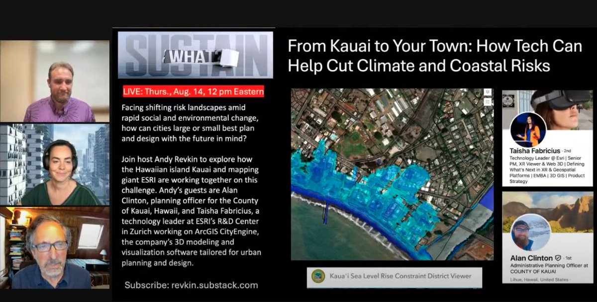
Join host Andy Revkin on #SustainWhat with Alan Clinton (Kauai County, Hawaii) & Taisha Fabricius (Esri Zurich) for a conversation on the future of urban planning & design. ow.ly/xvY050WJMpz

Join host Andy Revkin on #SustainWhat with Alan Clinton (Kauai County, Hawaii) & Taisha Fabricius (Esri Zurich) for a conversation on the future of urban planning & design. ow.ly/xvY050WJMpz
ArcGIS Urban (@arcgisurban) 's Twitter Profile Photo

Tired of not being able to view architectural models in their real-world context? With ArcGIS Urban Projects, cities can manage designs from concept to BIM, and explore real-time impacts—so everyone can see what’s being built, and why. ow.ly/HGoe50WOesh

ArcGIS Urban (@arcgisurban) 's Twitter Profile Photo

Learn how to build and share sites with ArcGIS Hub—perfect for showcasing your ArcGIS Urban content to stakeholders—using new workspaces, event tools, and searchable data catalogs. 📅 Join the webinar to see what's new on Sept 25! ow.ly/wXP250WQzw4

Learn how to build and share sites with ArcGIS Hub—perfect for showcasing your ArcGIS Urban content to stakeholders—using new workspaces, event tools, and searchable data catalogs. 📅 Join the webinar to see what's new on Sept 25! ow.ly/wXP250WQzw4
ArcGIS Urban (@arcgisurban) 's Twitter Profile Photo

The City of Dickinson, Texas, used a 3D GIS to innovate urban planning. A geospatial-powered immersive experience helped city leaders communicate the value of vertical growth and mixed-use development. ow.ly/LoB750WOf92

The City of Dickinson, Texas, used a 3D GIS to innovate urban planning. A geospatial-powered immersive experience helped city leaders communicate the value of vertical growth and mixed-use development. ow.ly/LoB750WOf92
ArcGIS Urban (@arcgisurban) 's Twitter Profile Photo

If you haven’t heard: #ArcGISUrban, #CityEngine, and all the tools planning departments need are now bundled into one user type, Professional Plus. See what this means for your team: ow.ly/gHSh50WPyh2

If you haven’t heard: #ArcGISUrban, #CityEngine, and all the tools planning departments need are now bundled into one user type, Professional Plus. See what this means for your team: ow.ly/gHSh50WPyh2
ArcGIS Urban (@arcgisurban) 's Twitter Profile Photo

Magna, Utah—featured in Disney films—is now the focus of a tech-driven revitalization. Using drone data and digital twins, planners are reimagining its historic core for a more connected, livable future. ow.ly/vs8B50WQzPa

Magna, Utah—featured in Disney films—is now the focus of a tech-driven revitalization. Using drone data and digital twins, planners are reimagining its historic core for a more connected, livable future. ow.ly/vs8B50WQzPa
ArcGIS Urban (@arcgisurban) 's Twitter Profile Photo

In this episode of the Reinventing Planning podcast, Keith Cooke (Esri) is joined by speakers Rodney Chatman, AICP, and Nicole Galasso, AICP as they discuss two very different projects in Pinellas County, Florida and how #GIS is an integral part of each. ow.ly/xlCl50WPA6u

In this episode of the Reinventing Planning podcast, Keith Cooke (Esri) is joined by speakers Rodney Chatman, AICP, and Nicole Galasso, AICP as they discuss two very different projects in Pinellas County, Florida and how #GIS is an integral part of each. ow.ly/xlCl50WPA6u
ArcGIS Urban (@arcgisurban) 's Twitter Profile Photo

Visualize zoning envelopes as transparent boundaries to show height limits. It's a quick way to spot redevelopment opportunities or catch proposals that aren’t compliant. Learn how: ow.ly/6g7850WWTmH

ArcGIS Urban (@arcgisurban) 's Twitter Profile Photo

"ArcGIS Urban and CityEngine allow us to transform abstract design ideas into a format that resonates with our community." — Rachel Nettles, City of Mesa See how these tools help the city bring their plans to life: ow.ly/X58050WWU8C

"ArcGIS Urban and CityEngine allow us to transform abstract design ideas into a format that resonates with our community." — Rachel Nettles, City of Mesa
See how these tools help the city bring their plans to life: ow.ly/X58050WWU8C