Meteorologist Amber Alexander (@amberawx) 's Twitter Profile
Meteorologist Amber Alexander

@amberawx

@IowaEverywhere Meteorologist. Human mom and Corgi mom. @UNLincoln Meteorology/Climatology Grad. Proud Ally.

ID: 2276386670

linkhttp://facebook.com/amberalexanderweather/ calendar_today04-01-2014 17:08:36

18,18K Tweet

6,6K Followers

1,1K Following

IowaEverywhere (@iowaeverywhere) 's Twitter Profile Photo

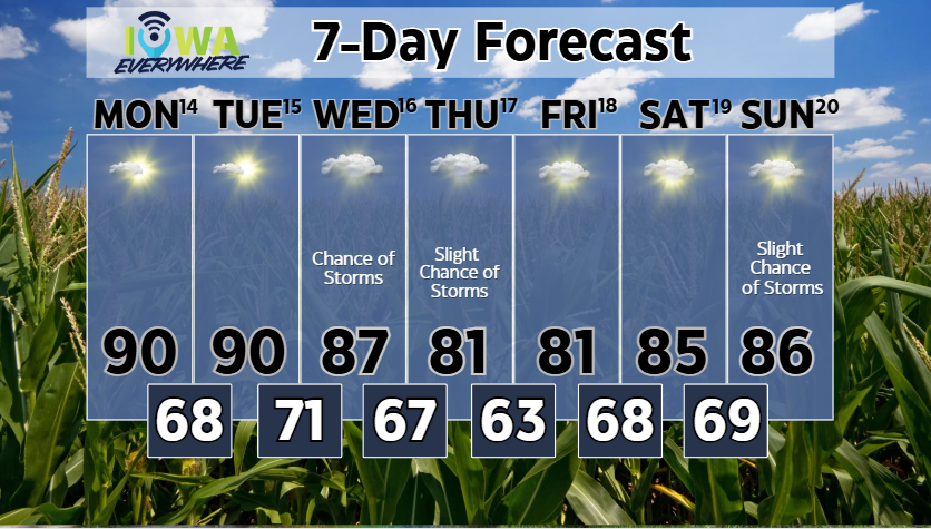
We're halfway through July and the forecast is looking very July-like this week. The work week will start off sunny and humid with highs around 90°. A few mid-week storms are expected with winds shifting north late Wednesday. That will keep highs in the low 80s for Thursday and

We're halfway through July and the forecast is looking very July-like this week. The work week will start off sunny and humid with highs around 90°. A few mid-week storms are expected with winds shifting north late Wednesday. That will keep highs in the low 80s for Thursday and
IowaEverywhere (@iowaeverywhere) 's Twitter Profile Photo

There are storm chances across central Iowa for the weekend, but most will be limited to the mornings. Meteorologist Meteorologist Amber Alexander is here to break down the central Iowa 3-day forecast.

IowaEverywhere (@iowaeverywhere) 's Twitter Profile Photo

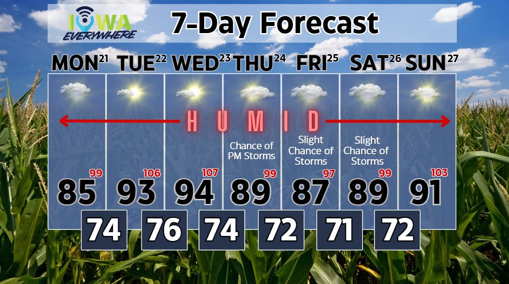
DANGEROUS HEAT is expected across central Iowa this week. Meteorologist Amber Alexander says a massive ridge at the mid-levels of the atmosphere will boost highs into the upper 80s to mid-90s this week and with south winds (and a lot of mature corn) humidity will be HIGH! Red

DANGEROUS HEAT is expected across central Iowa this week. Meteorologist Amber Alexander says a massive ridge at the mid-levels of the atmosphere will boost highs into the upper 80s to mid-90s this week and with south winds (and a lot of mature corn) humidity will be HIGH!

Red
IowaEverywhere (@iowaeverywhere) 's Twitter Profile Photo

A stationary boundary will bring storm chances across central and southern Iowa late Friday, but once clouds clear, we'll be left with the sunshine, heat, and high humidity for the rest of the weekend. It will feel like the low 90s on Friday, the upper 90s on Saturday, around

IowaEverywhere (@iowaeverywhere) 's Twitter Profile Photo

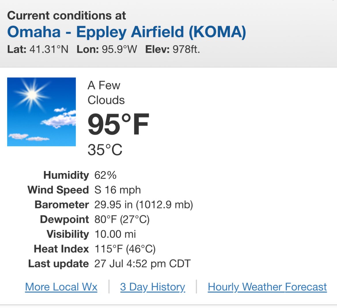
The heat and humidity will be absolutely horrendous over the next two days, with feel-like temperatures between 105 and 115°. A cold front will move through late Tuesday, bringing chances for showers and thunderstorms Tuesday night through Wednesday. Once the rain clears, we'll

The heat and humidity will be absolutely horrendous over the next two days, with feel-like temperatures between 105 and 115°.
A cold front will move through late Tuesday, bringing chances for showers and thunderstorms Tuesday night through Wednesday.
Once the rain clears, we'll
IowaEverywhere (@iowaeverywhere) 's Twitter Profile Photo

Meteorologist Meteorologist Amber Alexander has an update to today's weather. Note: Extreme heat is still expected this afternoon. A complex of storms starting across South Dakota will bring a threat of 70mph+ winds into Iowa tonight. Timing looks to be after 7 PM with the strongest storms

Meteorologist <a href="/AmberAwx/">Meteorologist Amber Alexander</a> has an update to today's weather. 
Note: Extreme heat is still expected this afternoon. 
A complex of storms starting across South Dakota will bring a threat of 70mph+ winds into Iowa tonight. Timing looks to be after 7 PM with the strongest storms
Meteorologist Amber Alexander (@amberawx) 's Twitter Profile Photo

A few snapshots of the wind field from this storm system developing over SE South Dakota as of 9:15 PM on 7/28. Wind gusts have ranged from 60-87mph with 1-3” limbs broken and shingles blown off a house. Looking at the colors, the pink and beige/yellow spots are where the radar

Meteorologist Amber Alexander (@amberawx) 's Twitter Profile Photo

9:45 PM and storms are now mainly in Nw Iowa. Power lines were reported down in Rock Valley. Isolated tornadoes are possible with this line, but the biggest threat is straight-line winds over 60mph. This line is currently moving east at 60 mph. That puts it around Pocahontas,

IowaEverywhere (@iowaeverywhere) 's Twitter Profile Photo

High pressure is in control of the weather pattern, and with the exception of a little smoke on Friday, the weekend looks fantastic if you want to get outside and hang out. Meteorologist Meteorologist Amber Alexander is here with the weekend forecast:

IowaEverywhere (@iowaeverywhere) 's Twitter Profile Photo

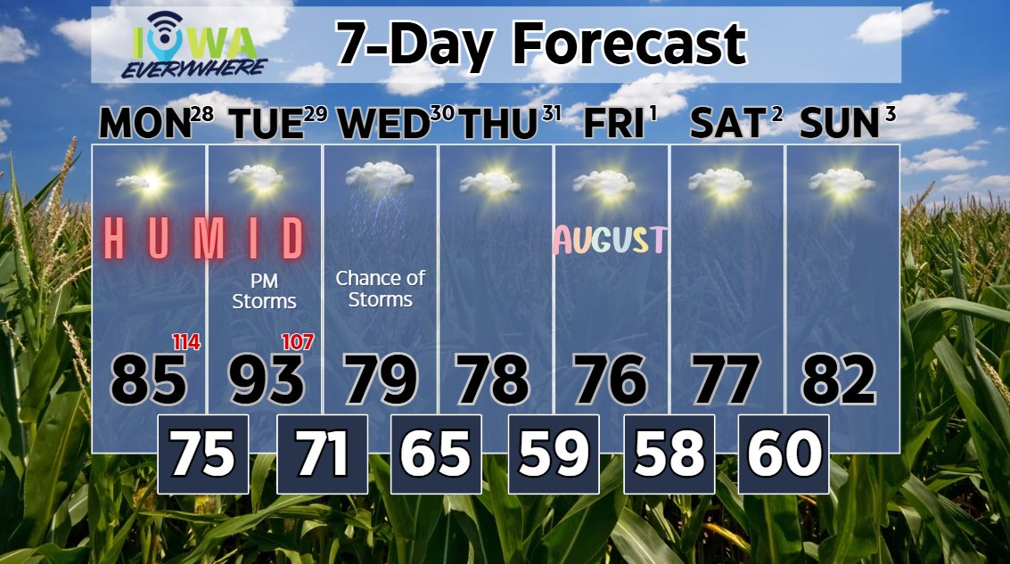
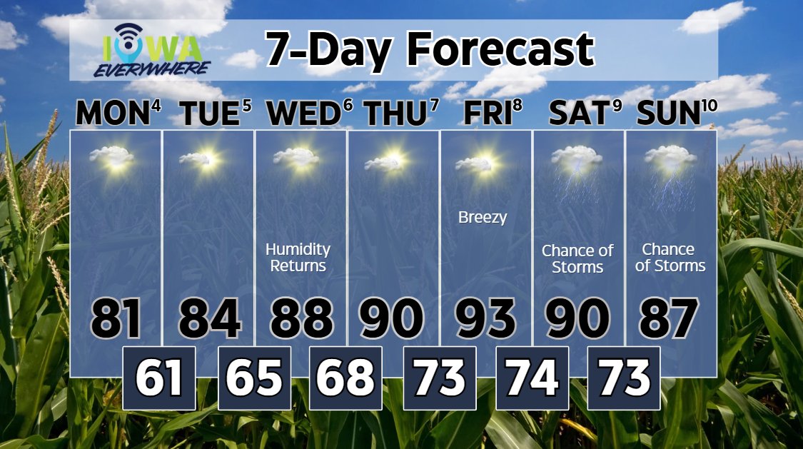
August is here, and while the last few days have been on the cooler side, the summer heat and humidity will return by mid-week. Highs will climb from the low 80s on Monday to the upper 80s on Wednesday and low 90s for the rest of the week. The work week stays dry with storm

August is here, and while the last few days have been on the cooler side, the summer heat and humidity will return by mid-week. Highs will climb from the low 80s on Monday to the upper 80s on Wednesday and low 90s for the rest of the week.
The work week stays dry with storm
IowaEverywhere (@iowaeverywhere) 's Twitter Profile Photo

An active pattern means storm chances will linger across Iowa over the weekend. But Friday does look fairly dry, just hot and humid. Meteorologist Meteorologist Amber Alexander has the details:

IowaEverywhere (@iowaeverywhere) 's Twitter Profile Photo

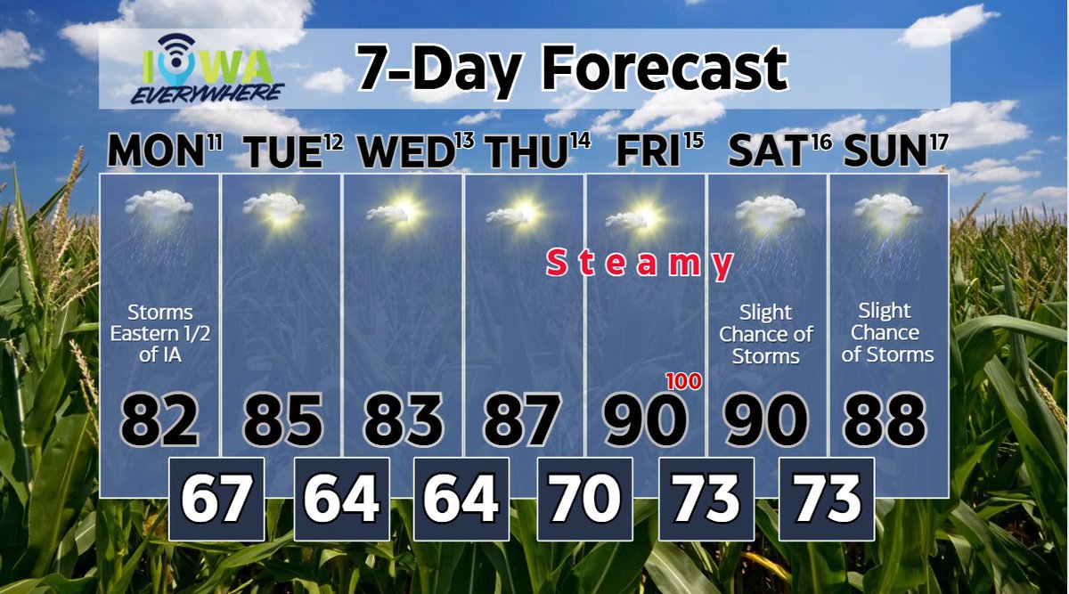
If you're headed to the Iowa State Fair 🌽 this week, most of the week will be fairly typical for August in Iowa. Some things worth noting: -A cold front stalls over the Eastern 1/2 of Iowa tonight, keeping storm chances through Monday. ⛈️ -The mid-week won't be terribly hot, but

If you're headed to the Iowa State Fair 🌽 this week, most of the week will be fairly typical for August in Iowa.
Some things worth noting:
-A cold front stalls over the Eastern 1/2 of Iowa tonight, keeping storm chances through Monday. ⛈️
-The mid-week won't be terribly hot, but
IowaEverywhere (@iowaeverywhere) 's Twitter Profile Photo

It's Thursday and I'm back for another weekend forecast. It's of course the last weekend of the Iowa State Fair and we're in for a HOT one. Highs will be in the 90s over the next few days, but it will feel like 100-110 during the afternoon. Isolated storm chances will remain

IowaEverywhere (@iowaeverywhere) 's Twitter Profile Photo

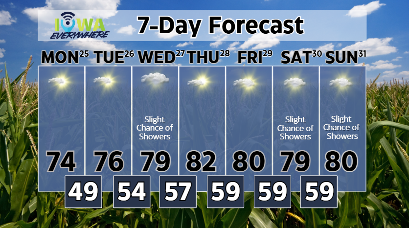
For the last week of August, it's looking like a MILD week of weather. Highs will be in the mid 70s to start the week, but increase to the low 80s starting Thursday. Overall high pressure will be in control most days with a weak wave bringing a slight chance of rain on Friday and

For the last week of August, it's looking like a MILD week of weather. Highs will be in the mid 70s to start the week, but increase to the low 80s starting Thursday. Overall high pressure will be in control most days with a weak wave bringing a slight chance of rain on Friday and
IowaEverywhere (@iowaeverywhere) 's Twitter Profile Photo

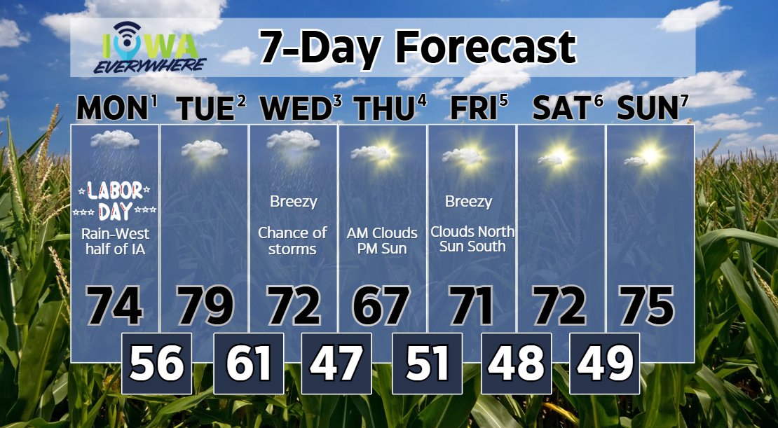
We hope you're enjoying your Labor Day weekend! ⛈️Early week -- Chances for RAIN will hang around the western half of Iowa through the Labor Day holiday, but we'll see some peeks of sun on Tuesday, bumping highs up near 80. 🍂Mid-week -- A deeper wave will dig in over the Midwest

We hope you're enjoying your Labor Day weekend!
⛈️Early week -- Chances for RAIN will hang around the western half of Iowa through the Labor Day holiday, but we'll see some peeks of sun on Tuesday, bumping highs up near 80.
🍂Mid-week -- A deeper wave will dig in over the Midwest