Andrew Shipley(@AShipleyWX) 's Twitter Profileg
Andrew Shipley

@AShipleyWX

@fox4now Meteorologist|Retired Student-Athlete|@FloridaTech Alumni|FMR @cbs4rgv, @KEZI9, & @NewsCenter1|Jesus+Nothing=Everything

ID:400472437

linkhttps://www.fox4now.com/andrew-shipley calendar_today29-10-2011 02:56:37

32,4K Tweets

2,2K Followers

6,9K Following

FFS Caloosahatchee(@FFS_cafc) 's Twitter Profile Photo

Location: Lee County, Cape Coral, Southeast Yucca Pens area.
Size Est. 3 Fires. Approximately 23 Acres total.
Containment: 100% Mop-up procedures in progress.
Number of units on scene: 3 FFS Tractor-Plows, local Fire Department, Aircraft in the area.

Location: Lee County, Cape Coral, Southeast Yucca Pens area. Size Est. 3 Fires. Approximately 23 Acres total. Containment: 100% Mop-up procedures in progress. Number of units on scene: 3 FFS Tractor-Plows, local Fire Department, Aircraft in the area.
account_circle
Fox 4 News(@Fox4Now) 's Twitter Profile Photo

Here's another reason why you should always lock your car! Florida Highway Patrol says this bear tried to break into a trooper's car.

Here's FHP's description of the 'suspect':

NAME: Unknown
ADDRESS: Unknown
AGE: Unknown
ALIAS: Teddy
WEIGHT: 500 plus pounds

📹: FHP SWFL

account_circle
Fox 4 News(@Fox4Now) 's Twitter Profile Photo

HEADS UP IF YOU'RE IN THE SOUTHEAST CAPE - CCPD is warning residents to avoid the area near SE 22nd Place and SE 32nd Terrace due to an underground propane tank leak. (10:10PM)

HEADS UP IF YOU'RE IN THE SOUTHEAST CAPE - CCPD is warning residents to avoid the area near SE 22nd Place and SE 32nd Terrace due to an underground propane tank leak. (10:10PM)
account_circle
NWS Climate Prediction Center(@NWSCPC) 's Twitter Profile Photo

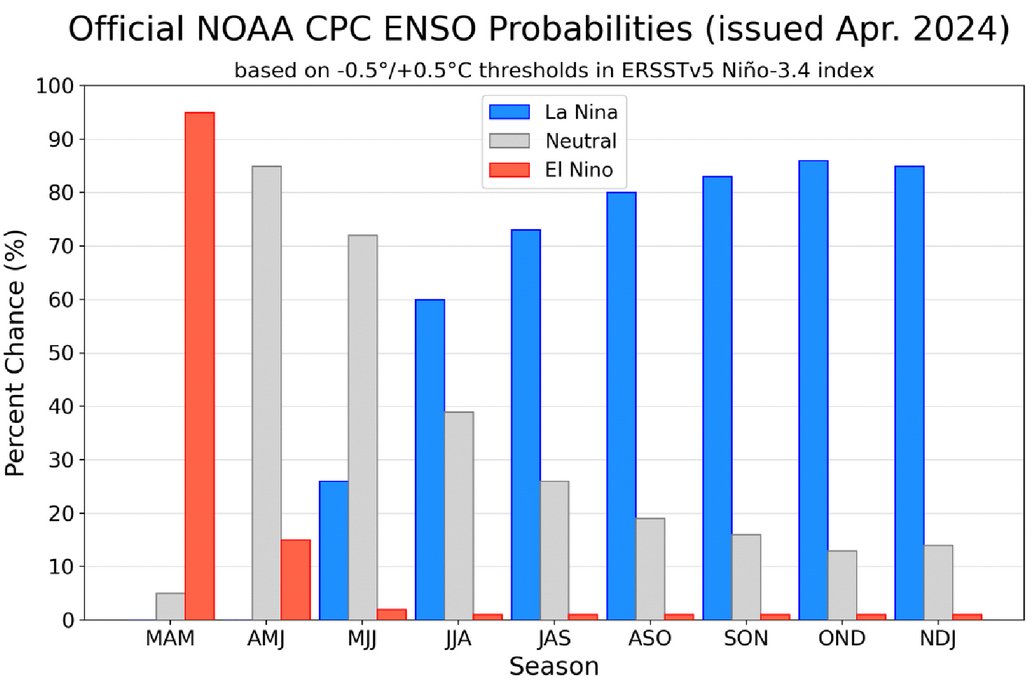
A transition from El Niño to -neutral is likely by April-June 2024 (85% chance), with the odds of La Niña developing by June-August 2024 (60% chance). An Advisory and Watch remain in effect. cpc.ncep.noaa.gov/products/analy…

A transition from El Niño to #ENSO-neutral is likely by April-June 2024 (85% chance), with the odds of La Niña developing by June-August 2024 (60% chance). An #ElNino Advisory and #LaNina Watch remain in effect. cpc.ncep.noaa.gov/products/analy…
account_circle
R A W S A L E R T S(@rawsalerts) 's Twitter Profile Photo

🚨 : As a confirmed large damaging tornado passes through as strong storms are passing through part of Florida this afternoon

📌 |

This afternoon, strong to severe storms are currently passing through the Florida area. The National Weather Service…

account_circle
Katie Walls(@KatieWallsTV) 's Twitter Profile Photo

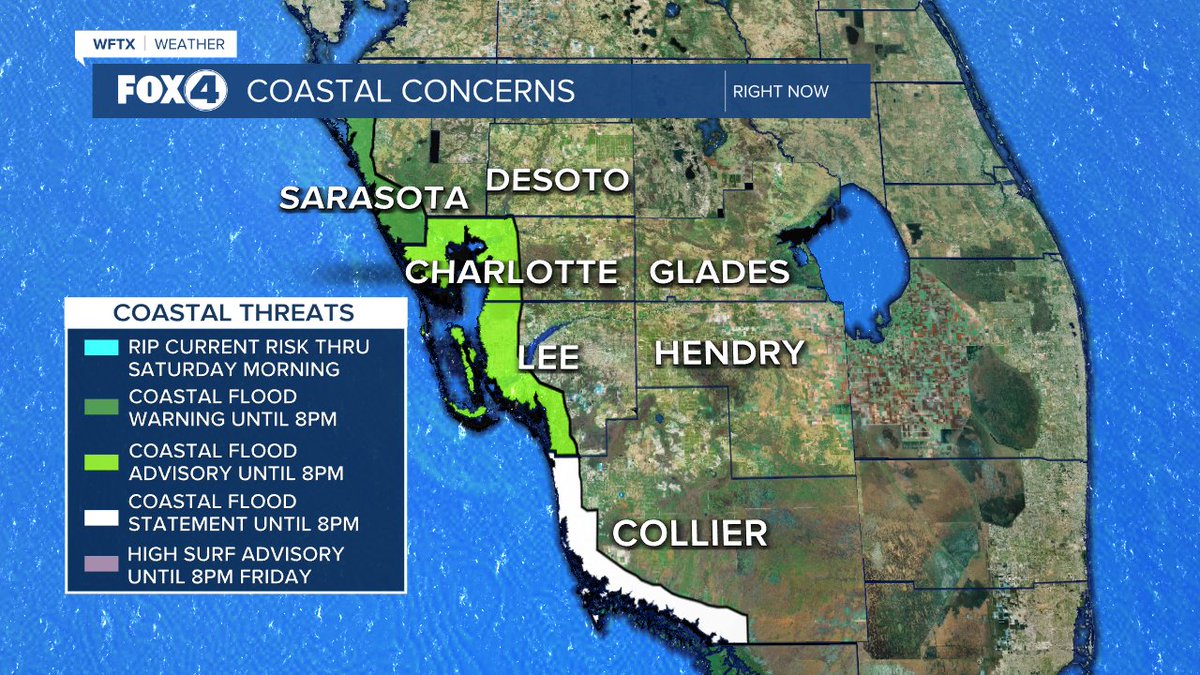
COASTAL CONCERNS CONTINUE: Coastal flooding is expected to be significant from Sarasota county northward. Minor coastal flooding is expected for Charlotte, Lee and Collier through this evening. Rip currents and high surf will continue through tomorrow.

COASTAL CONCERNS CONTINUE: Coastal flooding is expected to be significant from Sarasota county northward. Minor coastal flooding is expected for Charlotte, Lee and Collier through this evening. Rip currents and high surf will continue through tomorrow. #flwx
account_circle
FFS Caloosahatchee(@FFS_cafc) 's Twitter Profile Photo

Location: Collier County, 6th Ave NE. and Everglades Blvd.
Size Est: 10 Acres.
Containment: 100% Mop-up Operation in progress. Number of units on scene: 2 FFS Tractor-Plows, 1 Aircraft, and local Fire Department.

Location: Collier County, 6th Ave NE. and Everglades Blvd. Size Est: 10 Acres. Containment: 100% Mop-up Operation in progress. Number of units on scene: 2 FFS Tractor-Plows, 1 Aircraft, and local Fire Department.
account_circle
Katie Walls(@KatieWallsTV) 's Twitter Profile Photo

PARTIAL SOLAR ECLIPSE THIS AFTERNOON: SWFL may not be in the path of totality but we (along with the contiguous 48) will still enjoy a partial solar eclipse, viewable with 'eclipse' glasses or homemade projectors. The sun will be 52.6% obscured by the moon's shadow.

PARTIAL SOLAR ECLIPSE THIS AFTERNOON: SWFL may not be in the path of totality but we (along with the contiguous 48) will still enjoy a partial solar eclipse, viewable with 'eclipse' glasses or homemade projectors. The sun will be 52.6% obscured by the moon's shadow.
account_circle
Andrew Shipley(@AShipleyWX) 's Twitter Profile Photo

Well that’s blue-green algae. My girlfriend’s dad just sent me this video from Moody Creek. Lee DOH issued a health alert yesterday. Calusa Waterkeeper Fox 4 News

account_circle
Katie Walls(@KatieWallsTV) 's Twitter Profile Photo

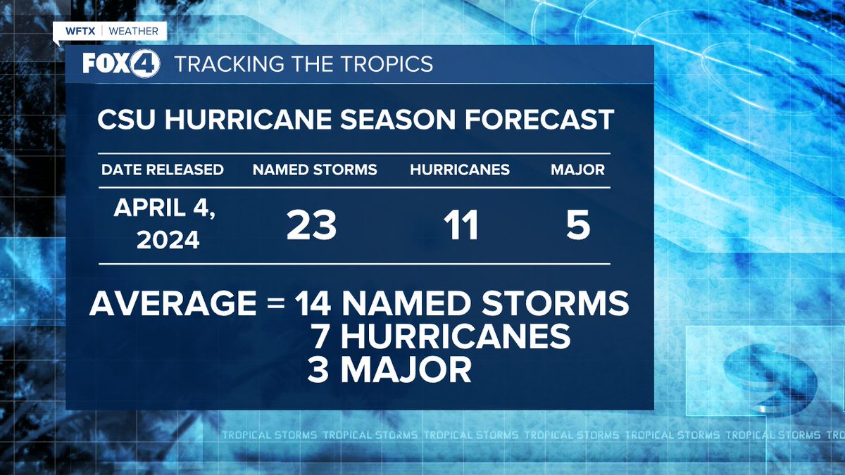
2024 HURRICANE OUTLOOK: Exceptionally warm sea-surface temperatures and a transition to La Nina are expected to lead to a very active hurricane season, which begins June 1. It doesn't necessarily mean that we'll take a direct hit, but now is the time to begin preparing.

2024 HURRICANE OUTLOOK: Exceptionally warm sea-surface temperatures and a transition to La Nina are expected to lead to a very active hurricane season, which begins June 1. It doesn't necessarily mean that we'll take a direct hit, but now is the time to begin preparing. #flwx
account_circle
Andrew Shipley(@AShipleyWX) 's Twitter Profile Photo

I went out to a recovering mangrove in Estero Bay with researchers from FGCU to see how it is recovering Post-Ian and to learn more about what these mangroves mean for way of life in SWFL!

fox4now.com/news/local-new…

account_circle
Philip Klotzbach(@philklotzbach) 's Twitter Profile Photo

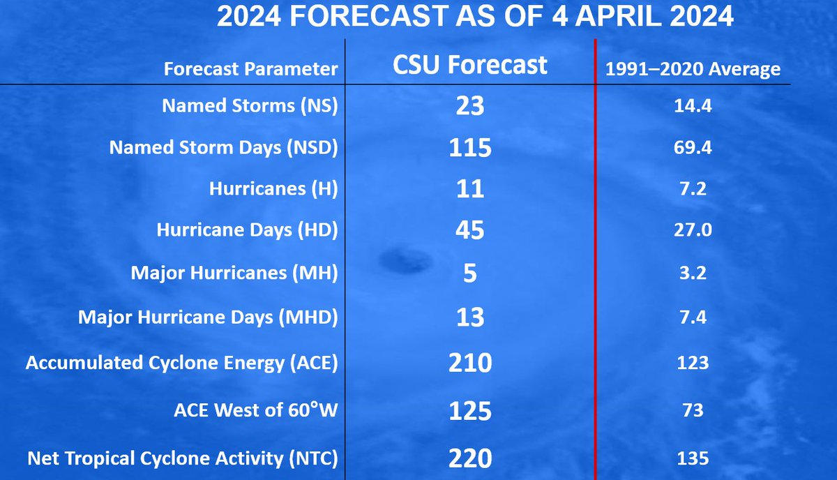
Atlantic seasonal forecast from Colorado State University calls for very active season: 23 named storms, 11 hurricanes & 5 major hurricanes. Extremely warm tropical Atlantic and likely are the primary reasons.

tropical.colostate.edu/Forecast/2024-…

Atlantic seasonal #hurricane forecast from @ColoradoStateU calls for very active season: 23 named storms, 11 hurricanes & 5 major hurricanes. Extremely warm tropical Atlantic and likely #LaNina are the primary reasons. tropical.colostate.edu/Forecast/2024-…
account_circle
Katie Walls(@KatieWallsTV) 's Twitter Profile Photo

HOUR-BY-HOUR TIME-LINE: Showers and storms will continue to weaken as they push into SWFL. Lightning and gusty wind will remain our primary threats, but our overall severe threat is low. Storms wind down by midnight with cooler, drier air filtering in overnight.

account_circle