UTDallasOEM (@utd_oemcp) 's Twitter Profile
UTDallasOEM

@utd_oemcp

#UTDallas Office of Emergency Management - UT Dallas OEM is creating a culture of emergency preparedness and response across the campus of UT Dallas.

ID: 2377371924

linkhttps://risk-safety.utdallas.edu/emergency-preparedness-and-response-programs/emergency-management/ calendar_today07-03-2014 16:49:21

349 Tweet

665 Takipçi

119 Takip Edilen

NWS Fort Worth (@nwsfortworth) 's Twitter Profile Photo

Isolated thunderstorms may occur this evening, followed more widespread showers & storms overnight into Monday. A few severe storms are possible, mainly overnight/Monday morning. #texomawx #ctxwx #dfwwx Damaging winds is the main severe threat, along with a few brief tornadoes.

Isolated thunderstorms may occur this evening, followed more widespread showers & storms overnight into Monday. A few severe storms are possible, mainly overnight/Monday morning. #texomawx #ctxwx #dfwwx Damaging winds is the main severe threat, along with a few brief tornadoes.
NCTCOG Emergency Preparedness (@nctcogep) 's Twitter Profile Photo

Congratulations Tiffany Parker(UT Dallas) for earning your CEM and walking the stage tonight at the International Association of Emergency Managers (IAEM) 2024 conference in Colorado Springs! We celebrate you and all your success in EM, congrats!!

Congratulations Tiffany Parker(UT Dallas) for earning your CEM and walking the stage tonight at the International Association of Emergency Managers (IAEM) 2024 conference in Colorado Springs! We celebrate you and all your success in EM, congrats!!
NWS Fort Worth (@nwsfortworth) 's Twitter Profile Photo

[12/24 11:05 AM] Heavy rainfall has moved into portions of northwest Dallas County, southwest Collin County, and southeast Denton County. Roadways may become flooded in locations like Plano, Carrollton, and Allen. Take caution if driving! #dfwwx #txwx

NWS Fort Worth (@nwsfortworth) 's Twitter Profile Photo

Another round of storms will impact North and Central Texas today. A few storms may be severe, particularly in East Texas. Storms will move east of the area by sunset. #texomawx #ctxwx #dfwwx #etxwx

Another round of storms will impact North and Central Texas today. A few storms may be severe, particularly in East Texas. Storms will move east of the area by sunset. #texomawx #ctxwx #dfwwx #etxwx
NWS Fort Worth (@nwsfortworth) 's Twitter Profile Photo

After a foggy start Saturday morning, storms are expected to develop east of Hwy 281 between 10AM-3PM. There is a low chance for severe storms capable of producing large hail and damaging winds along/east of I-35. All storm activity should push into East TX by Saturday evening.

After a foggy start Saturday morning, storms are expected to develop east of Hwy 281 between 10AM-3PM. There is a low chance for severe storms capable of producing large hail and damaging winds along/east of I-35. All storm activity should push into East TX by Saturday evening.
NWS Fort Worth (@nwsfortworth) 's Twitter Profile Photo

Severe Thunderstorm Watch #717 is in effect until noon today. Hail up to 2 inches in diameter is the primary threat. #dfwwx #ctxwx #etxwx #texomawx

Severe Thunderstorm Watch #717 is in effect until noon today. Hail up to 2 inches in diameter is the primary threat. #dfwwx #ctxwx #etxwx #texomawx
ERCOT (@ercot_iso) 's Twitter Profile Photo

ERCOT is monitoring the cold weather approaching Texas and will keep Texans informed on grid conditions through our various communication channels. Grid conditions are expected to be normal. For regular updates, follow ERCOT’s official social media channels and continue to

ERCOT is monitoring the cold weather approaching Texas and will keep Texans informed on grid conditions through our various communication channels. Grid conditions are expected to be normal. For regular updates, follow ERCOT’s official social media channels and continue to
NWS Fort Worth (@nwsfortworth) 's Twitter Profile Photo

It is going to be cold next week! Overnight lows in the 20s. 🥶 Wind chills in the teens each morning. Bundle up! 🧥 Cold temps will stick around for several days. 🕐

It is going to be cold next week! 

Overnight lows in the 20s. 🥶
Wind chills in the teens each morning. Bundle up! 🧥
Cold temps will stick around for several days. 🕐
NWS Fort Worth (@nwsfortworth) 's Twitter Profile Photo

⚠️Tuesday AM Update⚠️: Most likely snow amounts of 3-6" are across North TX (now highest north of I-20/near the Red River), with Central TX likely to see 0-1" snow, as well as icing up to 0.10" . Travel impacts are likely Thursday into Friday! 🚗 #dfwwx #ctxwx #txwx

⚠️Tuesday AM Update⚠️: Most likely snow amounts of 3-6" are across North TX (now highest north of I-20/near the Red River), with Central TX likely to see 0-1" snow, as well as icing up to 0.10" . Travel impacts are likely Thursday into Friday! 🚗  #dfwwx #ctxwx #txwx
NWS Fort Worth (@nwsfortworth) 's Twitter Profile Photo

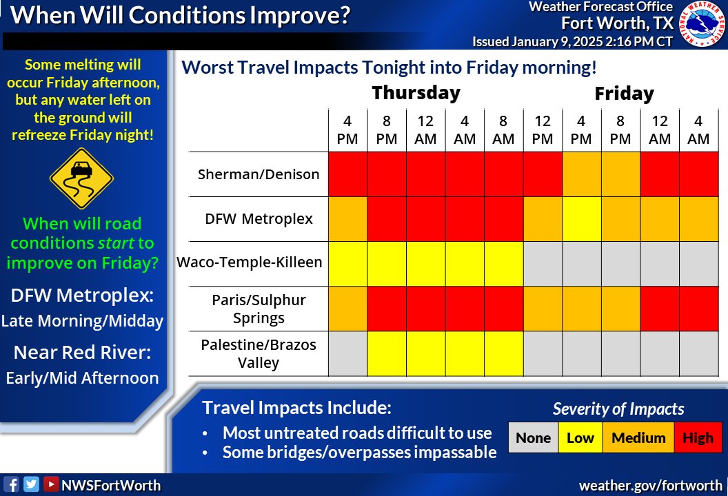
⚠️Travel conditions will be their WORST tonight into Friday morning. ⚠️Any water on the roads refreezes Friday night with hazardous travel again Sat. morning! When will things start to improve? DFW: Late morning/midday Friday Red River: early/mid afternoon Friday #dfwwx #txwx

⚠️Travel conditions will be their WORST tonight into Friday morning. ⚠️Any water on the roads refreezes Friday night with hazardous travel again Sat. morning!

When will things start to improve? 
DFW: Late morning/midday Friday
Red River: early/mid afternoon Friday #dfwwx #txwx
NWS Fort Worth (@nwsfortworth) 's Twitter Profile Photo

🥶Black ice will lead to hazardous driving conditions tonight into Saturday morning! 🧊 Some melting will occur this afternoon, however travel conditions will rapidly deteorate tonight as temps plummet into the teens and 20s quickly refreezing any liquid on the roadways. #txwx

🥶Black ice will lead to hazardous driving conditions tonight into Saturday morning! 🧊

Some melting will occur this afternoon, however travel conditions will rapidly deteorate tonight as temps plummet into the teens and 20s quickly refreezing any liquid on the roadways. #txwx
NWS Fort Worth (@nwsfortworth) 's Twitter Profile Photo

There may be some light snow early next week, but the bigger concern will be frigid weather for multiple days following Friday night's arctic front. Bundle up and protect pets, pipes, plants an people! #texomawx #ctxwx #dfwwx

There may be some light snow early next week, but the bigger concern will be frigid weather for multiple days following Friday night's arctic front. Bundle up and protect pets, pipes, plants an people! #texomawx #ctxwx #dfwwx
NWS Fort Worth (@nwsfortworth) 's Twitter Profile Photo

Despite a gradual warming trend, cold nights will continue through the end of the workweek. Above-normal temperatures and a chance of rain can be expected this weekend. #ctxwx #texomawx #dfwwx

Despite a gradual warming trend, cold nights will continue through the end of the workweek. Above-normal temperatures and a chance of rain can be expected this weekend. #ctxwx #texomawx #dfwwx
NWS Fort Worth (@nwsfortworth) 's Twitter Profile Photo

Rain chances will increase Wednesday and continue through Thursday afternoon. A few strong to severe storms are possible Wednesday night into Thursday morning, which is also when the heaviest rain will occur. Be prepared for interruptions to outdoor activities! #dfwwx #ctxwx

Rain chances will increase Wednesday and continue through Thursday afternoon.  A few strong to severe storms are possible Wednesday night into Thursday morning, which is also when the heaviest rain will occur. Be prepared for interruptions to outdoor activities! #dfwwx #ctxwx
UTDallasOEM (@utd_oemcp) 's Twitter Profile Photo

The outdoor warning system was activated by City of Richardson and other neighboring jurisdictions for incoming high wind of 70+ mph. Stay indoors, tune to local media.

NWS Fort Worth (@nwsfortworth) 's Twitter Profile Photo

Rain chances returntonight & Saturday with a cold front. Lightning & brief heavy rain are the main threats, although there is a low potential for a strong to severe storm or two. Take it slow on wet roads and plan for interruptions to outdoor activities. #texomawx #ctxwx #dfwwx

Rain chances returntonight & Saturday with a cold front. Lightning & brief heavy rain are the main threats, although there is a low potential for a strong to severe storm or two. Take it slow on wet roads and plan for interruptions to outdoor activities. #texomawx #ctxwx #dfwwx
NWS Fort Worth (@nwsfortworth) 's Twitter Profile Photo

A 🔥RED FLAG WARNING 🔥 is now in effect for ALL of North and Central Texas from 7 AM to 9 PM Friday! Take extra caution to AVOID any activities that could start wildfires! 🚫🔥 Heed all warnings and burn bans from local officials! #dfwwx #ctxwx #txwx

A 🔥RED FLAG WARNING 🔥 is now in effect for ALL of North and Central Texas from 7 AM to 9 PM Friday! 

Take extra caution to AVOID any activities that could start wildfires! 🚫🔥 Heed all warnings and burn bans from local officials! #dfwwx #ctxwx #txwx
NWS Fort Worth (@nwsfortworth) 's Twitter Profile Photo

A High Wind Warning & Wind Advisory is in effect for Friday from 7 AM to 7 PM, with areas of blowing dust expected as well. Be VERY careful tomorrow especially if driving! ⚠️ High Wind Warning: gusts up to 65 mph. Wind Advisory: gusts up to 50 mph. #dfwwx #ctxwx #txwx

A High Wind Warning & Wind Advisory is in effect for Friday from 7 AM to 7 PM, with areas of blowing dust expected as well. Be VERY careful tomorrow especially if driving! ⚠️

High Wind Warning: gusts up to 65 mph.
Wind Advisory: gusts up to 50 mph.
#dfwwx #ctxwx #txwx
UTDallasOEM (@utd_oemcp) 's Twitter Profile Photo

Comets, Collin and Dallas counties are under a burn ban today. All outdoor fires are strictly prohibited during this time.

Comets, Collin and Dallas counties are under a burn ban today. All outdoor fires are strictly prohibited during this time.
UTDallasOEM (@utd_oemcp) 's Twitter Profile Photo

🚨 Join Us This Saturday! 🚨 Enjoy free food, exciting raffles, and get up close with emergency vehicles! 🚒🚑 📅 Date: This Saturday 4/12 ⌛️ Time: 11am - 3pm 📍 Location: UT Dallas Visitor Center/Lot J Bring your family and friends for a fun and informative day! 👪

🚨 Join Us This Saturday! 🚨

Enjoy free food, exciting raffles, and get up close with emergency vehicles! 🚒🚑

📅 Date: This Saturday 4/12
⌛️ Time: 11am - 3pm
📍 Location: UT Dallas Visitor Center/Lot J

Bring your family and friends for a fun and informative day! 👪