Kalin Mitchell(@KalinMitchelCTV) 's Twitter Profileg
Kalin Mitchell

@KalinMitchelCTV

Chief Meteorologist for @CTVAtlantic. West coast to east coast story. Worked the weather from mountains, prairies, lakes, and coasts. Husband and father.

ID:51205716

linkhttps://atlantic.ctvnews.ca/ calendar_today26-06-2009 20:11:26

19,9K Tweet

17,7K Takipçi

1,0K Takip Edilen

Kalin Mitchell(@KalinMitchelCTV) 's Twitter Profile Photo

WATCH: Tuesday rain totals in the Maritimes and a risk of patchy frost in northwestern New Brunswick by early Thursday morning: atlantic.ctvnews.ca/video/c2930959…

account_circle
Kalin Mitchell(@KalinMitchelCTV) 's Twitter Profile Photo

Rain/downpours clearing Cape Breton by around 10 PM. A diminished risk of t-storms with the scattered showers moving into northwest NB by then as well.

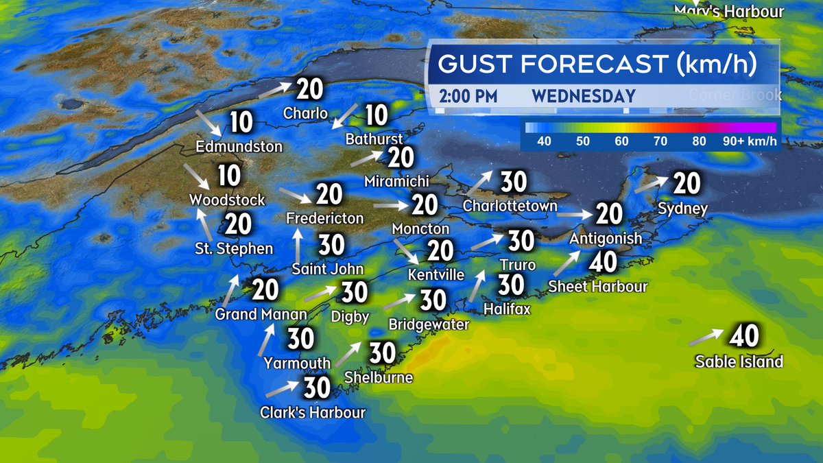
Cloudy periods and patchy fog/drizzle tonight. Clearing to mix sun & cloud on Wed. Blustery SW wind but down compared to today.

Rain/downpours clearing Cape Breton by around 10 PM. A diminished risk of t-storms with the scattered showers moving into northwest NB by then as well. Cloudy periods and patchy fog/drizzle tonight. Clearing to mix sun & cloud on Wed. Blustery SW wind but down compared to today.
account_circle
Kalin Mitchell(@KalinMitchelCTV) 's Twitter Profile Photo

Rain continues to move through. A few areas still to watch for thunderstorms Tuesday afternoon and evening. More here: atlantic.ctvnews.ca/rain-and-thund…

account_circle
Kalin Mitchell(@KalinMitchelCTV) 's Twitter Profile Photo

Increasing cloudiness tonight. Chance of showers northern/western NB. Patchy fog/drizzle possible elsewhere.

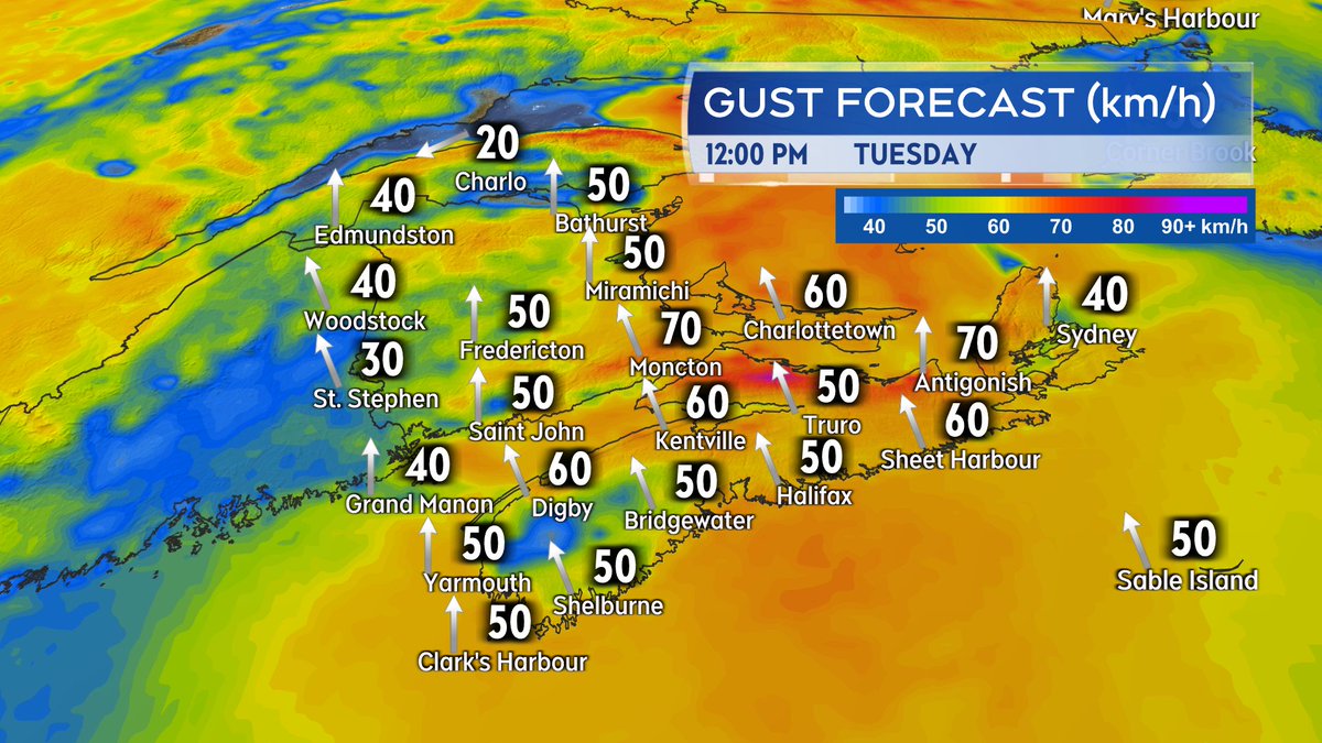
Rounds of rain and showers move west-to-east on Tuesday. A risk of thunderstorms within the rain. Be weather aware. A gusty southerly wind accompanies the wet weather.

Increasing cloudiness tonight. Chance of showers northern/western NB. Patchy fog/drizzle possible elsewhere. Rounds of rain and showers move west-to-east on Tuesday. A risk of thunderstorms within the rain. Be weather aware. A gusty southerly wind accompanies the wet weather.
account_circle
Kalin Mitchell(@KalinMitchelCTV) 's Twitter Profile Photo

This is a circumhorizontal arc. The rainbow like appearance created by the refraction of sunlight by tiny ice crystals that comprise high cloud such as cirrus clouds. Typically located further away from the suns position in the sky than a sun halo.

account_circle
Kalin Mitchell(@KalinMitchelCTV) 's Twitter Profile Photo

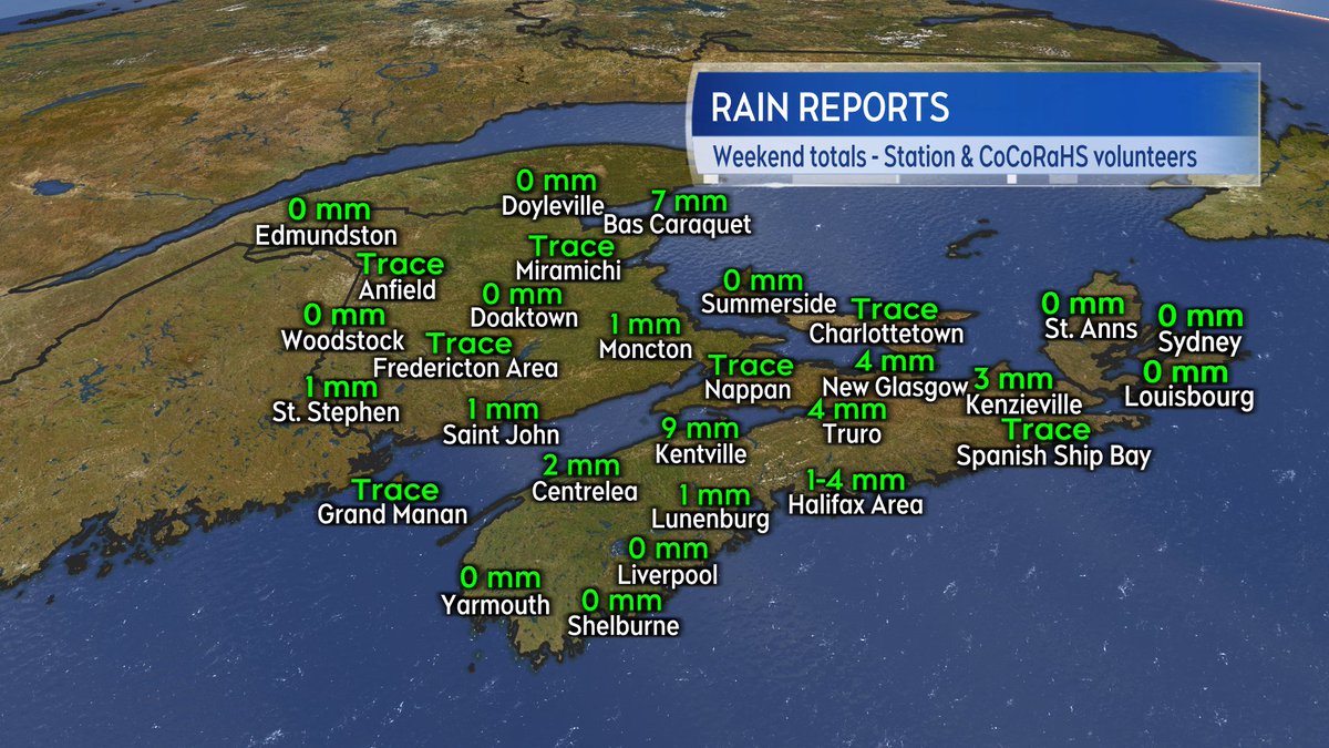
Only a few millimetres of rain reported here and there around the region this past weekend due to some scattered showers.

Wet weather more widespread on Tuesday. More on that here: atlantic.ctvnews.ca/maritime-weath…

Only a few millimetres of rain reported here and there around the region this past weekend due to some scattered showers. Wet weather more widespread on Tuesday. More on that here: atlantic.ctvnews.ca/maritime-weath…
account_circle
Kalin Mitchell(@KalinMitchelCTV) 's Twitter Profile Photo

Previous Tornado watches/t-storm warnings in NB have ended.

A chance of isolated thunderstorms for NB and PEI this evening. A chance of isolated thunderstorms for NS this evening and overnight.

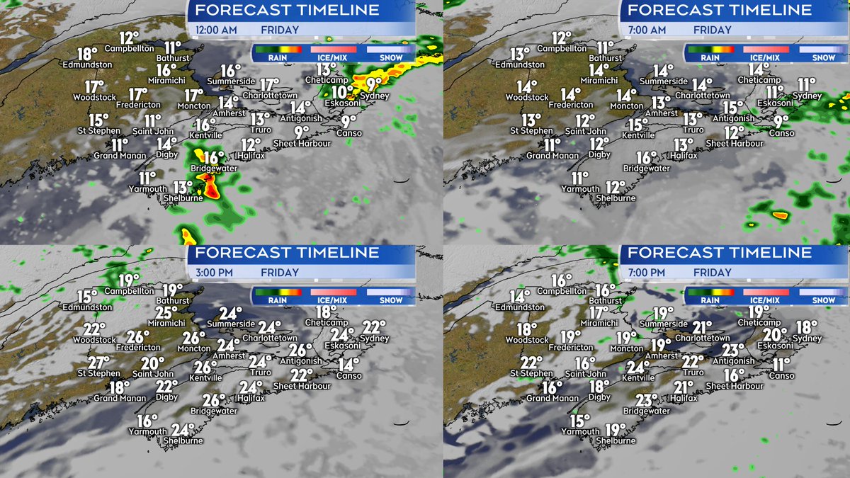
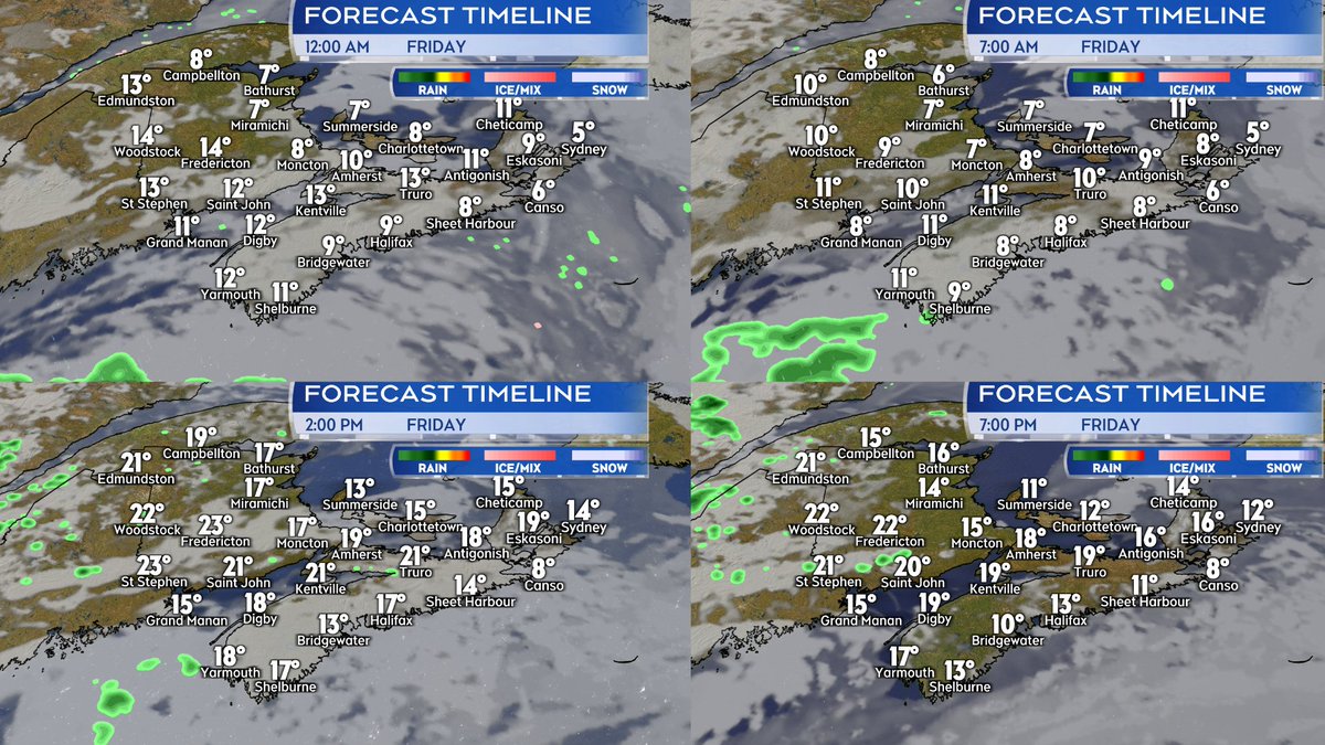
Mixed sun and cloud with isolated showers for Friday. Still very warm for late May.

Previous Tornado watches/t-storm warnings in NB have ended. A chance of isolated thunderstorms for NB and PEI this evening. A chance of isolated thunderstorms for NS this evening and overnight. Mixed sun and cloud with isolated showers for Friday. Still very warm for late May.
account_circle
Kalin Mitchell(@KalinMitchelCTV) 's Twitter Profile Photo

A number of severe thunderstorms continue to move west-to-east across NB. Severe Thunderstorm Watch/Warnings continues.

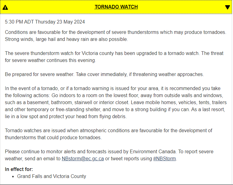
A Tornado Watch issued for Victoria County NB. The situation with t-storms can change quickly. Latest watch/warnings always at: weather.gc.ca

A number of severe thunderstorms continue to move west-to-east across NB. Severe Thunderstorm Watch/Warnings continues. A Tornado Watch issued for Victoria County NB. The situation with t-storms can change quickly. Latest watch/warnings always at: weather.gc.ca
account_circle
Kalin Mitchell(@KalinMitchelCTV) 's Twitter Profile Photo

My understanding is that we will be streaming the Canadian Hurricane Centre briefing at atlantic.ctvnews.ca, starting at 1 PM.

account_circle
Kalin Mitchell(@KalinMitchelCTV) 's Twitter Profile Photo

Busy day for weather. The National Hurricane Center of the NOAA has released their 2024 forecast for the Atlantic hurricane season. Expected to be very active.

More on that here: atlantic.ctvnews.ca/more/national-…

Canadian Hurricane Centre with a briefing on the season this afternoon.

account_circle
Kalin Mitchell(@KalinMitchelCTV) 's Twitter Profile Photo

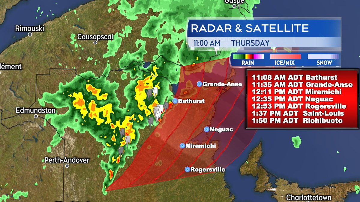
Line of broken t-storms continues across northern NB. Along with lighting they are producing downpours. A Severe Thunderstorm Watch issued by EC.

Line moving eastward at about 50-60 km/h. That will take it towards some of the eastern-most communities of NB over next 2-3 hours.

Line of broken t-storms continues across northern NB. Along with lighting they are producing downpours. A Severe Thunderstorm Watch issued by EC. Line moving eastward at about 50-60 km/h. That will take it towards some of the eastern-most communities of NB over next 2-3 hours.
account_circle
Kalin Mitchell(@KalinMitchelCTV) 's Twitter Profile Photo

Feeling like a summer evening for many communities in the region.

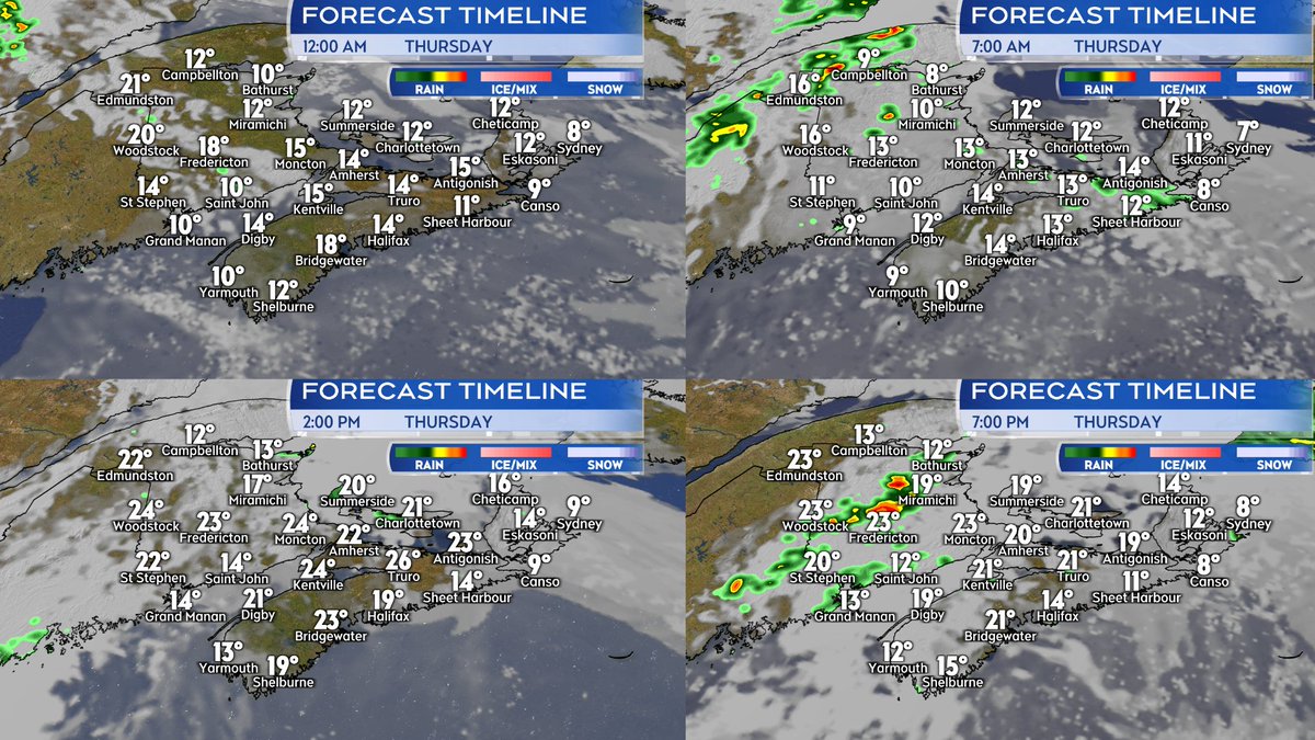
Mild, partly cloudy, and with fog patches tonight. Rounds of rain/showers come across NB tomorrow, very intermittent but a higher chance of t-storms with them. Chance of showers PEI and eastern NS through the day.

Feeling like a summer evening for many communities in the region. Mild, partly cloudy, and with fog patches tonight. Rounds of rain/showers come across NB tomorrow, very intermittent but a higher chance of t-storms with them. Chance of showers PEI and eastern NS through the day.
account_circle
Kalin Mitchell(@KalinMitchelCTV) 's Twitter Profile Photo

Shelf cloud. Usually associated with convective weather, the type of weather that gives us pop-up showers/t-storms. Doesn't always come along with rain reaching the ground or an active t-storm. This might have been what was left of a t-storm that moved across PEI hours earlier.

account_circle
Kalin Mitchell(@KalinMitchelCTV) 's Twitter Profile Photo

Isolated showers ending this evening. A few clouds and fog patches overnight, mild temperatures.

A mix of sun and cloud Wed. Quite warm and a touch humid away from areas directly exposed to ocean breezes. A chance of spotty PM showers/small t-storms.

atlantic.ctvnews.ca/more/warm-may-…

Isolated showers ending this evening. A few clouds and fog patches overnight, mild temperatures. A mix of sun and cloud Wed. Quite warm and a touch humid away from areas directly exposed to ocean breezes. A chance of spotty PM showers/small t-storms. atlantic.ctvnews.ca/more/warm-may-…
account_circle
Kalin Mitchell(@KalinMitchelCTV) 's Twitter Profile Photo

Broken showers and small t-storms in southern NB and parts of northern mainland NS will end later this evening. Rest of the night partly cloudy with patchy fog.

Mixed sun and cloud tomorrow. Cooler where an easterly wind blows onshore. Other areas could reach low-mid twenties.

Broken showers and small t-storms in southern NB and parts of northern mainland NS will end later this evening. Rest of the night partly cloudy with patchy fog. Mixed sun and cloud tomorrow. Cooler where an easterly wind blows onshore. Other areas could reach low-mid twenties.
account_circle