

Ujaval Gandhi(@spatialthoughts) 's Twitter Profile Photo

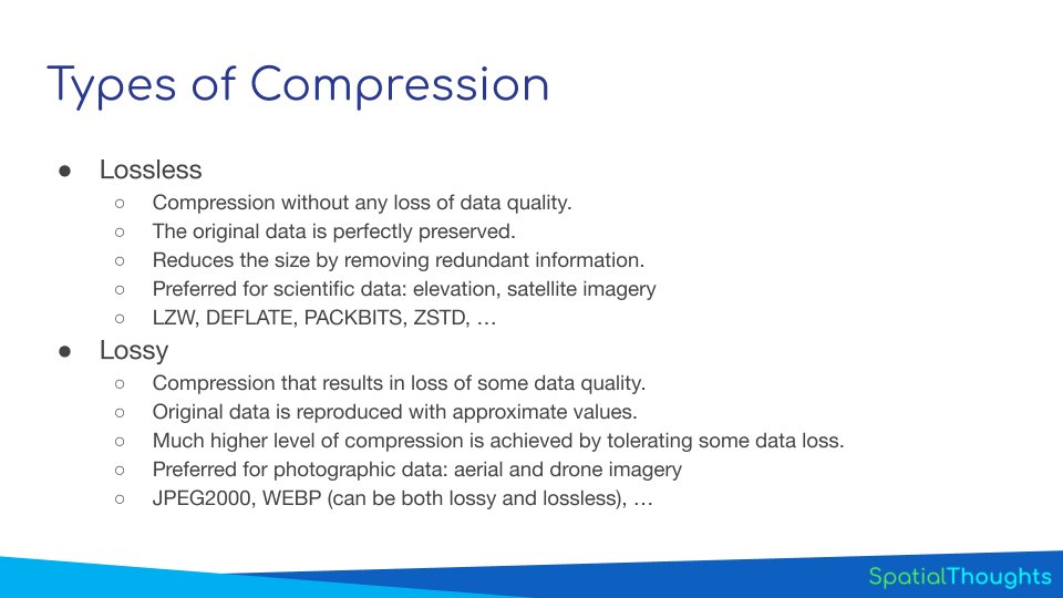
One of the most important concepts in raster image processing is 'compression'. Learn about lossless vs lossy compression and advanced options in for compression that will help you optimize storage space. youtube.com/watch?v=9iG7uo…

One of the most important concepts in raster image processing is 'compression'. Learn about lossless vs lossy compression and advanced options in #GDAL for #GeoTIFF compression that will help you optimize storage space. youtube.com/watch?v=9iG7uo…
account_circle
(一財)日本地図センター(@JapanMapCenter) 's Twitter Profile Photo

日本地図センターでは、レイヤーごとに使いやすいGeoTIFF形式へ変換し、DVDに格納する「電子地形図50000TIFF画像変換サービス」を行っています。DVDにはつなぎ合わせに便利な「図郭ファイル」を同梱してお届けしています。 今回の刊行で「東京(5339)」が提供開始となります。 net.jmc.or.jp/mapdata/gsi_on…

日本地図センターでは、レイヤーごとに使いやすいGeoTIFF形式へ変換し、DVDに格納する「電子地形図50000TIFF画像変換サービス」を行っています。DVDにはつなぎ合わせに便利な「図郭ファイル」を同梱してお届けしています。 今回の刊行で「東京(5339)」が提供開始となります。 net.jmc.or.jp/mapdata/gsi_on…
account_circle
Mark Krutov(@kromark) 's Twitter Profile Photo

Still GeoTIFF Planet image taken on May 1st for those of you who want to take a closer look. Coordinates: 45.68612, 34.42202.

Still GeoTIFF @planet image taken on May 1st for those of you who want to take a closer look. Coordinates: 45.68612, 34.42202.
account_circle
Cramel Iffy(@150000__) 's Twitter Profile Photo

プログラミング何もわからん……
今Rustで地形を3Dで描画するソフトウェアを作ろうと思って、流石にwgpuでやるのはしんどそうだったからBevy(ゲームエンジン)でやろうと思いBevyのお勉強を始めた。
これ終わったら次にGeoTiffファイルから高度情報とかを取得して、そこから地形を生成しなきゃなのだ

account_circle
dronevids(@AZDroneVids) 's Twitter Profile Photo

Here’s a great tutorial for using QGIS to extract the contour lines from your DTM and DSM.

Note: For WebODM you should use the RAW GeoTiff as your selection for the DTM/DSM image export. It will appear black and white in QGIS.

youtu.be/0oyZ0gwLKXY?fe…

account_circle
Groundsure(@Groundsure) 's Twitter Profile Photo

Join us on the 23rd May to hear from our experts and learn all about GeoTiff mapping and ArcGIS. Book your free place now! hubs.ly/Q02vQRVG0

account_circle
SoftPortal.com(@softportal) 's Twitter Profile Photo

QField for QGIS 3.2.2 - Congo softportal.com/software-50387…

Мобильное расширение популярной ГИС-платформы, которое обеспечивает возможность работы с геоданными в полевых условиях, предлагая полную функциональность QGIS на мобильных устройствах. Работает с данными в форматах GeoTIFF...

QField for QGIS 3.2.2 - Congo softportal.com/software-50387…

Мобильное расширение популярной ГИС-платформы, которое обеспечивает возможность работы с геоданными в полевых условиях, предлагая полную функциональность QGIS на мобильных устройствах. Работает с данными в форматах GeoTIFF...
account_circle
だし巻きタマゴ(@egg_of_study) 's Twitter Profile Photo

平面直角座標系のgeotiffを、WGS座標系に変換して吐き出す方法をご存知の方いらっしゃいませんか。

account_circle
Ian Jorre Beyst(@ianbeyst) 's Twitter Profile Photo

terence Let us know which one won :)
I also have some old code for a simple tool to display huge (e.g. 100k x 100k) geoTIFF files in a feh-like interface, let me know if you're interested and I'll see if I can polish it and put it on github.

account_circle
Hugh Graham @hughagraham@fosstodon.org(@hughagraham) 's Twitter Profile Photo

Darren Wiens I submitted an issue on this FYI - glad I saw your post, I totally just assumed these were valid COGs without checking! github.com/facebookresear…

account_circle
Tech Maven Geospatial(@TechMavenGeo) 's Twitter Profile Photo

Darren Wiens World Resources Inst Meta Land & Carbon Lab Mapbox I love following along to all of your work it's very impressive I'm wowed by this one.
I built my own mapbox RGB encoded terrain tiles in the past for many projects including underwater bathymetry
I love this concept of doing it dynamically using Cloud optimized geotiff

account_circle
ぴっかりん(@ra0kley) 's Twitter Profile Photo

Mapflow フリー版のWeb版とQGISプラグインの違いはこんな感じかな。
■ Web版では可能
- 任意のGeoTIFFやXYZ Tiles形式の画像の判読
 ちなみに、地理院の空中写真やPLATEAUオルソでも判読してみたけど、精度は上の結果と変わらない感じであった。
■ QGISプラグインでは可能
- 判読結果の保存

account_circle
Joshua Stevens(@jscarto) 's Twitter Profile Photo

Aravind 🌍 🛰 Data formats are only boring until they reach social media. Just whisper ‘NetCDF > GeoTIFF’ and watch…

Seriously though, very good slide!

account_circle
Пул Потокофф(@NaMi____NaMi) 's Twitter Profile Photo

trolleway.com Хм. Т.е. Geotiff это контейнер с сжатым изображением (ями) и метаинформацией?

account_circle
Joe Desbonnet(@JoeDesbonnet) 's Twitter Profile Photo

Keiko Meta World Resources Inst Samapriya Roy, PhD. Nice. Have you been able to download the GeoTIFF files from AWS? I've been trying the AWS CLI with no joy: 'Forbidden' error. (command I'm using: 'aws s3 cp --no-sign-request s3://dataforgood-fb-data/forests/v1/europe/alsgedi_europe_v6_float/chm/1221002223.tif .' )

account_circle
ORE LABO(テニス、農、猫、気象)(@orelabo) 's Twitter Profile Photo

Yohei Takano 自分の周りの人はその方が多かったですね(拡張子を変える手間がありましたが)。少なくともcsv、netcdf、geotiff、datは扱えると思います。

自分が研究していたころはmatplotlibを知ってる人が周囲にいなかったのが口惜しい私も知らなかったんですがね。

account_circle
Yohan Iddawela(@yohaniddawela) 's Twitter Profile Photo

Cloud Optimized GeoTIFFs aim to speed up the process of visualising TIFF files.

With COGs, you no longer have to batch download a bunch of files as a TAR.

Instead, you can directly access any band AND any part of a GeoTIFF you're interested in.

How does this work?

account_circle
trolleway.com(@trolleway) 's Twitter Profile Photo

Пул Потокофф я по работе в стеке ГИС работаю, там везде все растры в GeoTIFF. И геопривязка нормальная, и сколько хочешь каналов в файл добавляй, и битность любая, хоть 1, хоть 16
account_circle