Namma Karnataka Weather(@namma_vjy) 's Twitter Profileg
Namma Karnataka Weather

@namma_vjy

ಕರ್ನಾಟಕದ ಹವಾಮಾನ

Hi, Its Vijay here .A weather enthusiast who loves rains anywhere and anytime.
Disclaimer: Not a official weather Site

ID:1307351233

calendar_today27-03-2013 12:17:47

10,6K Tweets

12,6K Followers

202 Following

Namma Karnataka Weather(@namma_vjy) 's Twitter Profile Photo

SOUTHWEST MONSOON ONSET DETAILS

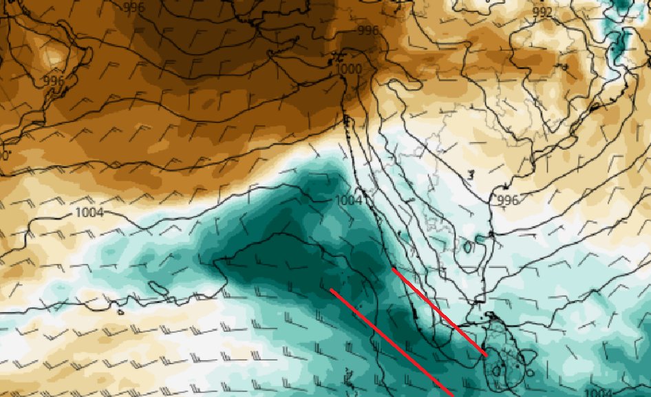
Friends, appears like the legendary SOUTHWEST MONSOON would set in over Southern Most Kerala on 29th or 30th of May.

1) Somalia Jet stream showing a massive uptick in another 3-4 days. The classical curving surging winds across Indian Ocean and

SOUTHWEST MONSOON ONSET DETAILS Friends, appears like the legendary SOUTHWEST MONSOON would set in over Southern Most Kerala on 29th or 30th of May. 1) Somalia Jet stream showing a massive uptick in another 3-4 days. The classical curving surging winds across Indian Ocean and
account_circle
Namma Karnataka Weather(@namma_vjy) 's Twitter Profile Photo

RAINFALL DATA FROM UDUPI DISTRICT RECORDED YESTERDAY

Very widespread heavy rains recorded across Udupi District yesterday.

Many places getting > 100mm.

UDUPI :HEJAMADI (GP) topping with 187mm
UDUPI :THENKA(GP) next at 186mm

Note: This is quite rare. This kind of heavy rains

RAINFALL DATA FROM UDUPI DISTRICT RECORDED YESTERDAY Very widespread heavy rains recorded across Udupi District yesterday. Many places getting > 100mm. UDUPI :HEJAMADI (GP) topping with 187mm UDUPI :THENKA(GP) next at 186mm Note: This is quite rare. This kind of heavy rains
account_circle
Namma Karnataka Weather(@namma_vjy) 's Twitter Profile Photo

RAINFALL DATA FROM DAKSHINA KANNADA RECORDED YESTERDAY

Some very big numbers from MANGALORE, BANTWAL and PUTTUR taluks.

PADUPANAMBUR(GP) in MANGALORE records whopping 189mm

KILPADY(GP) in MANGALORE records 131mm

Note:
This is quite rare. This kind of heavy rains we get to

RAINFALL DATA FROM DAKSHINA KANNADA RECORDED YESTERDAY Some very big numbers from MANGALORE, BANTWAL and PUTTUR taluks. PADUPANAMBUR(GP) in MANGALORE records whopping 189mm KILPADY(GP) in MANGALORE records 131mm Note: This is quite rare. This kind of heavy rains we get to
account_circle
Namma Karnataka Weather(@namma_vjy) 's Twitter Profile Photo

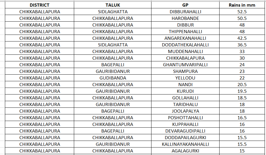
RAINFALL DATA RECORDED FROM CHIKKABALLAPURA DISTRICT RECORDED YESTERDAY SHARED

Widespread rains across CHIKKABALLAPURA and GAURIBIDANUR recorded yesterday.

RAINFALL DATA RECORDED FROM CHIKKABALLAPURA DISTRICT RECORDED YESTERDAY SHARED Widespread rains across CHIKKABALLAPURA and GAURIBIDANUR recorded yesterday. #KarnatakaRains
account_circle
Namma Karnataka Weather(@namma_vjy) 's Twitter Profile Photo

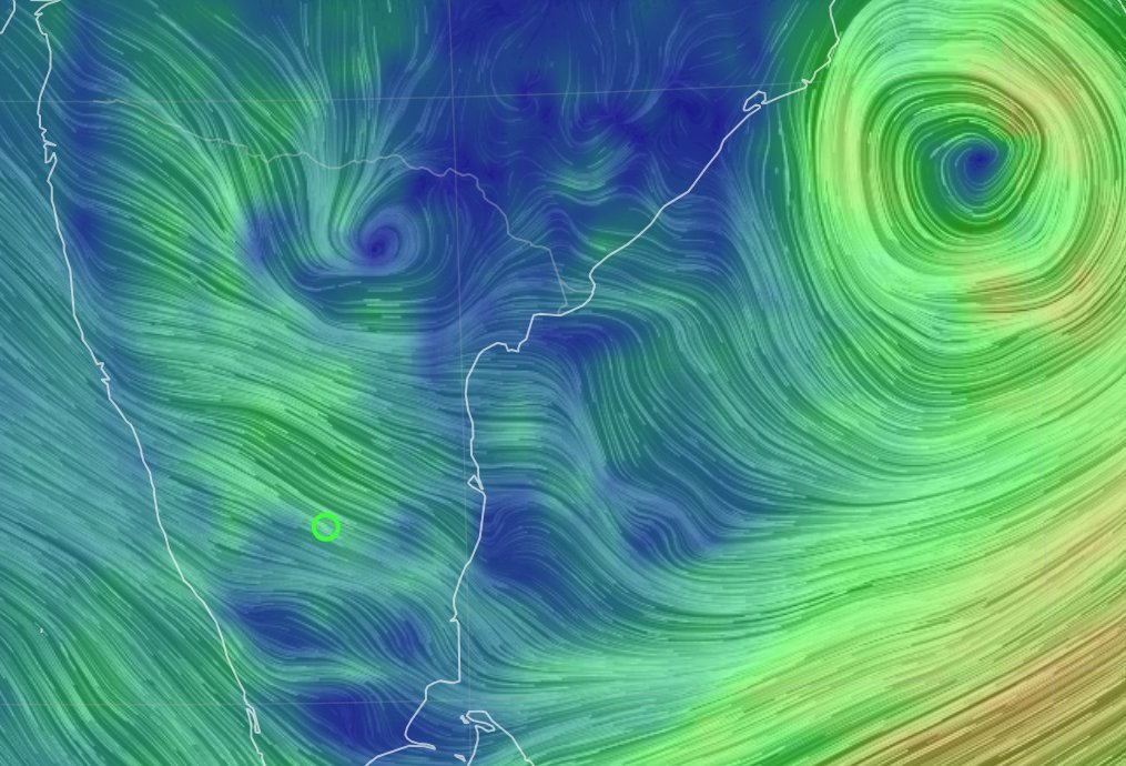
SATURDAY FORECAST FOR KARNATAKA

The Arabian sea LPA has dissipated and the BOB LPA has moved away and turned in to a depression.
The seesaw setup that we witnessed since 19th May is obsolete now. As a result the widespread rains that Karnataka experienced in the last few days

SATURDAY FORECAST FOR KARNATAKA The Arabian sea LPA has dissipated and the BOB LPA has moved away and turned in to a depression. The seesaw setup that we witnessed since 19th May is obsolete now. As a result the widespread rains that Karnataka experienced in the last few days
account_circle
Namma Karnataka Weather(@namma_vjy) 's Twitter Profile Photo

BENGALURU FORECAST FOR SATURDAY:

So finally the weekend is here :)

Lets check what's cooking on the weather front.
The wind speed at 2kms above surface has spiked to over 20knots. Quite difficult for any worthwhile TS to get generated with such high wind speed. But RH is good

BENGALURU FORECAST FOR SATURDAY: So finally the weekend is here :) Lets check what's cooking on the weather front. The wind speed at 2kms above surface has spiked to over 20knots. Quite difficult for any worthwhile TS to get generated with such high wind speed. But RH is good
account_circle
Namma Karnataka Weather(@namma_vjy) 's Twitter Profile Photo

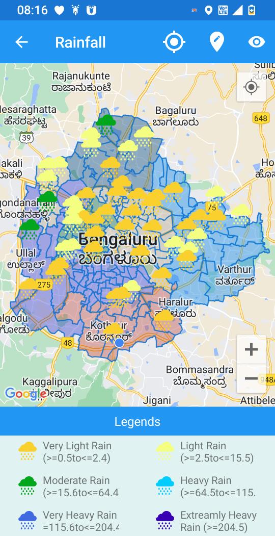
🌧️ Rainfall Map from yesterday shared for BENGALURU

Parts of North, West and North West Bengaluru received light to moderate showers last evening.


🌧️ Rainfall Map from yesterday shared for BENGALURU Parts of North, West and North West Bengaluru received light to moderate showers last evening. #BangaloreRains #BengaluruRains
account_circle
Namma Karnataka Weather(@namma_vjy) 's Twitter Profile Photo

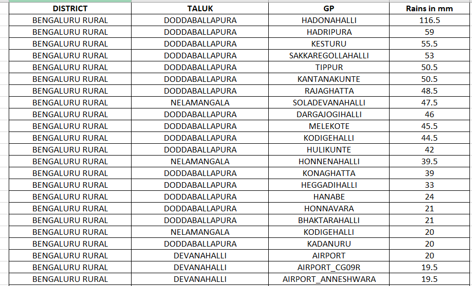
RAINFALL NUMBERS FOR BENGALURU RURAL FROM YESTEDAY SHARED

DODDABALLAPURA, DEVANAHALLI and NELAMANGALA received widespread showers last evening.

The toppers are:
DODDABALLAPURA HADONAHALLI :116.5mm DODDABALLAPURA HADRIPURA: 59mm DODDABALLAPURA KESTURU: 55.5mm

RAINFALL NUMBERS FOR BENGALURU RURAL FROM YESTEDAY SHARED DODDABALLAPURA, DEVANAHALLI and NELAMANGALA received widespread showers last evening. The toppers are: DODDABALLAPURA HADONAHALLI :116.5mm DODDABALLAPURA HADRIPURA: 59mm DODDABALLAPURA KESTURU: 55.5mm
account_circle
Namma Karnataka Weather(@namma_vjy) 's Twitter Profile Photo

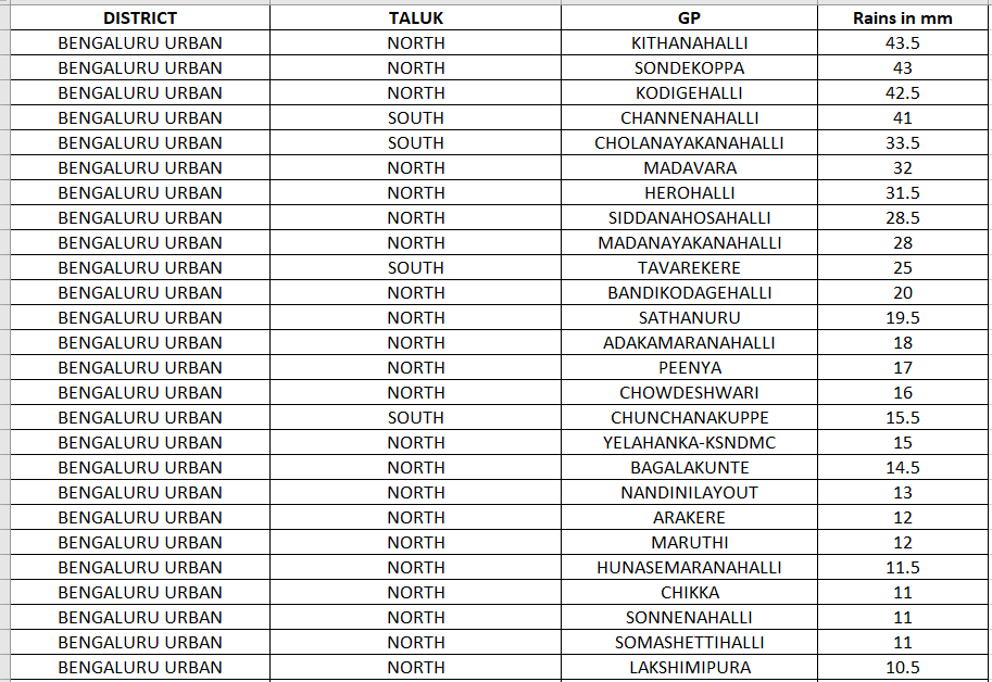
RAINFALL NUMBERS FROM LAST EVENING SHOWERS SHARED FOR BENGALURU:

LOCATION RAINFALL (mm)
Herohalli (Rrnagarzone) 31.5
Peenya Indl.Area (Dasarahallizone) 17
Chowdeshwari Ward (Yelahankazone) 16
Yelahanka-Ksndmc (Yelahankazone) 15
Bagalakunte (Dasarahallizone) 14.5

account_circle
Namma Karnataka Weather(@namma_vjy) 's Twitter Profile Photo

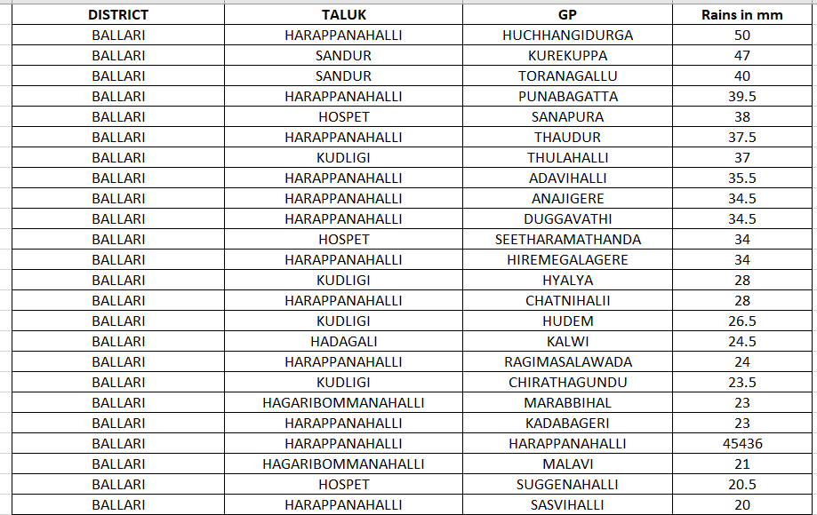
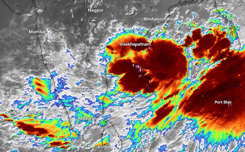
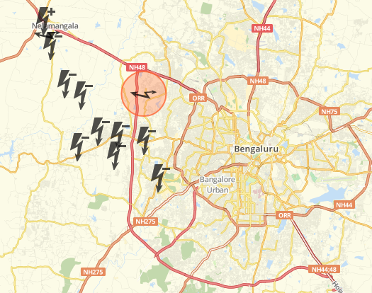
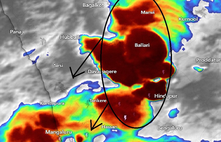
9.55 PM UPDATE: LONG TS CHAIN ACROSS NORTH AND SI KARNATAKA

Long TS across Kalaburagi-Ballari-Tumkuru districts.

Seems to be sliding SW.

9.55 PM UPDATE: LONG TS CHAIN ACROSS NORTH AND SI KARNATAKA Long TS across Kalaburagi-Ballari-Tumkuru districts. Seems to be sliding SW. #KarnatakaRains
account_circle
Namma Karnataka Weather(@namma_vjy) 's Twitter Profile Photo

Current rainfall 🌧️ in Bengaluru:

Areas where it is drizzling 🌧️
- Cantonment area ↔️
- Rajajinagar ⬆️
- Malleswaram ↔️
- Sadashivanagar ↔️
- Seshadripuram ↔️
- Shivajinagar ↔️
- Vasanth Nagar ↔️
- CV Raman Nagar ↔️
- Whitefield ↔️
- Kalyan Nagar ↔️
- Peenya ↔️
- Bommasandra ↔️

account_circle
Namma Karnataka Weather(@namma_vjy) 's Twitter Profile Photo

5.45 PM UPDATE: INTENSE TS NW OF BENGALURU

Intense TS to the NW of Bengaluru.
The 850 hpa steering is from NNW to SSE. High possibility of it impact West, NW , CBD and parts South Bengaluru.

If the TS can expand to North Bengaluru, then East would also get rains.

Lets see!

5.45 PM UPDATE: INTENSE TS NW OF BENGALURU Intense TS to the NW of Bengaluru. The 850 hpa steering is from NNW to SSE. High possibility of it impact West, NW , CBD and parts South Bengaluru. If the TS can expand to North Bengaluru, then East would also get rains. Lets see!
account_circle
Namma Karnataka Weather(@namma_vjy) 's Twitter Profile Photo

Current rainfall 🌧️ in Bengaluru:

Areas where it is raining 🌧️⛈️
- Nayandahalli ↔️

Areas where it is drizzling 🌧️
- Rajajinagar ↔️
- Malleswaram ↔️
- Hebbal ↔️
- Jalahalli ↔️
- Mathikere ↔️
- Peenya ↔️
- Yeshwanthpur ↔️
- Banashankari ↔️
- Basaveshwaranagar ↔️
- Kamakshipalya

account_circle