profile-img
David Hill

@dfosterhill

Professor. Nat Geo Explorer, POW Science Alliance Member. I study water and its response to climate from headwaters to the coast. @[email protected]

calendar_today03-08-2016 16:25:19

2,6K Tweets

946 Followers

649 Following

David Hill(@dfosterhill) 's Twitter Profile Photo

So, people seemed to enjoy the brainstorm on these crazy features from Great Salt Lake, UT. I'll try summarize and provide some additional information. Please chime in! Thread follows. 🧵

So, people seemed to enjoy the brainstorm on these crazy features from Great Salt Lake, UT. I'll try summarize and provide some additional information. Please chime in! Thread follows. 🧵
account_circle
David Hill(@dfosterhill) 's Twitter Profile Photo

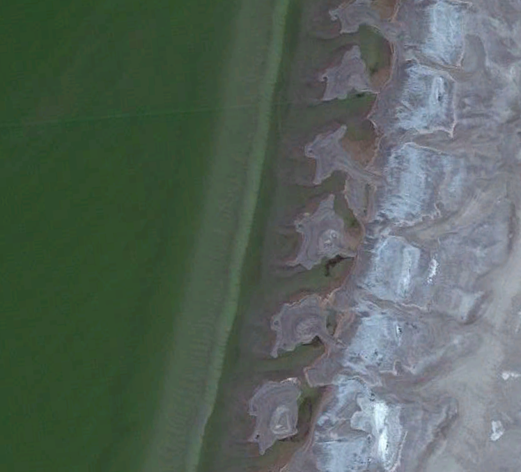
I only found these in the October 2022 imagery. Images from many previous years did not show features anything remotely like this. The 'wavelength' of these features is about 150 feet. Location is: 40°44'59.05'N, 112°11'58.54'W. On southeast corner of the lake.

account_circle
David Hill(@dfosterhill) 's Twitter Profile Photo

There was discussion of 'beach cusps.' I don't think this is it. Beach cusps are often associated with 'surf beat' or infragravity waves on open coastlines. Classic nonlinear wave theory allows you to estimate wavelength...

account_circle
David Hill(@dfosterhill) 's Twitter Profile Photo

Given the frequencies expected on a lake with limited fetch, this just does not seem like the primary mechanism. There was also talk of them being associated with surface discharge. Several people wondered about a rapid drawdown of the lake resulting in runoff channels...

account_circle
David Hill(@dfosterhill) 's Twitter Profile Photo

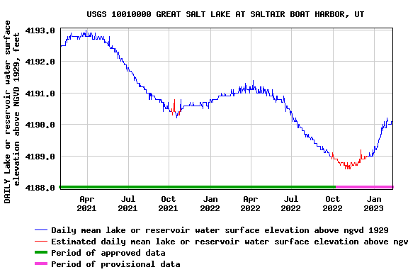
Here is the gage data associated with that location. October 2022 is associated with a period of lake decline (almost 2.5 ft in 6 months). October is near the point of the lowest lake level.

Here is the gage data associated with that location. October 2022 is associated with a period of lake decline (almost 2.5 ft in 6 months). October is near the point of the lowest lake level.
account_circle
David Hill(@dfosterhill) 's Twitter Profile Photo

So, yes, I'm inclined to associate the features with areas of surface drainage. BUT WHY the incredibly regular wavelength? That I can not grasp. Who's crowd-sourcing a paper on this with me? 😀

account_circle
David Hill(@dfosterhill) 's Twitter Profile Photo

David Hill Interesting paper here: authors.library.caltech.edu/106279/3/2020J…
Doesn’t explain your features but discusses other factors.
account_circle