Remote Sensing MDPI(@RemoteSens_MDPI) 's Twitter Profileg
Remote Sensing MDPI

@RemoteSens_MDPI

No. 1 #remotesensing #openaccess journal in Remote Sensing Category in #WoS, published by @MDPIOpenAccess; IF 2022 5.0; CiteScore 2021 7.9; #mdpiremotesensing

ID:3376897745

linkhttp://www.mdpi.com/journal/remotesensing calendar_today15-07-2015 05:11:07

11,1K Tweets

17,2K Followers

980 Following

Follow People
Remote Sensing MDPI(@RemoteSens_MDPI) 's Twitter Profile Photo

🌳A Comparison of Modeling Methods for Predicting Attributes Using Metrics
by Angel Adhikari, Cristian R. Montes and Alicia Peduzzi

mdpi.com/2072-4292/15/5…

🌳A Comparison of Modeling Methods for Predicting #Forest Attributes Using #Lidar Metrics by Angel Adhikari, Cristian R. Montes and Alicia Peduzzi mdpi.com/2072-4292/15/5… #vegetation
account_circle
Remote Sensing MDPI(@RemoteSens_MDPI) 's Twitter Profile Photo

🏢A Multi-Scale Edge Constraint Network for the Fine of Buildings from Images
by Zhenqing Wang, Yi Zhou, Futao Wang, Shixin Wang, Gang Qin, Weijie Zou and Jinfeng Zhu

mdpi.com/2072-4292/15/4…

🏢A Multi-Scale Edge Constraint Network for the Fine #Extraction of Buildings from #RemoteSensing Images by Zhenqing Wang, Yi Zhou, Futao Wang, Shixin Wang, Gang Qin, Weijie Zou and Jinfeng Zhu mdpi.com/2072-4292/15/4… #AI
account_circle
Remote Sensing MDPI(@RemoteSens_MDPI) 's Twitter Profile Photo

📝A Novel Dual-Encoder Model for and Joint Classification via Contrastive Learning
by Haibin Wu, Shiyu Dai, Chengyang Liu, Aili Wang and Yuji Iwahori

mdpi.com/2072-4292/15/4…

📝A Novel Dual-Encoder Model for #Hyperspectral and #LiDAR Joint Classification via Contrastive Learning by Haibin Wu, Shiyu Dai, Chengyang Liu, Aili Wang and Yuji Iwahori mdpi.com/2072-4292/15/4… #deeplearning
account_circle
Remote Sensing MDPI(@RemoteSens_MDPI) 's Twitter Profile Photo

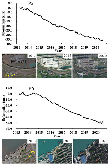
📣Monitoring along the Subways in Shanghai on the Basis of Time-Series
by Jinhua Zhang, Changqing Ke, Xiaoyi Shen, Jinxin Lin and Ru Wang

mdpi.com/2072-4292/15/4…

📣Monitoring #LandSubsidence along the Subways in Shanghai on the Basis of Time-Series #InSAR by Jinhua Zhang, Changqing Ke, Xiaoyi Shen, Jinxin Lin and Ru Wang mdpi.com/2072-4292/15/4… #geology
account_circle
Remote Sensing MDPI(@RemoteSens_MDPI) 's Twitter Profile Photo

🌽Identifying Corn Lodging in the Mature Period Using Chinese -1 PMS Images
by Xianda Huang, Fu Xuan, Yi Dong, Wei Su, Xinsheng Wang, Jianxi Huang, Xuecao Li, Yelu Zeng, Shuangxi Miao and Jiayu Li

mdpi.com/2072-4292/15/4…

🌽Identifying Corn Lodging in the Mature Period Using Chinese #GF-1 PMS Images by Xianda Huang, Fu Xuan, Yi Dong, Wei Su, Xinsheng Wang, Jianxi Huang, Xuecao Li, Yelu Zeng, Shuangxi Miao and Jiayu Li mdpi.com/2072-4292/15/4… #crops
account_circle
Remote Sensing MDPI(@RemoteSens_MDPI) 's Twitter Profile Photo

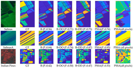
🖼PSSA: PCA-Domain Superpixelwise Singular Spectral Analysis for Unsupervised Image Classification
by Qiaoyuan Liu, Donglin Xue, Yanhui Tang, Yongxian Zhao, Jinchang Ren and Haijiang Sun

mdpi.com/2072-4292/15/4…

🖼PSSA: PCA-Domain Superpixelwise Singular Spectral Analysis for Unsupervised #Hyperspectral Image Classification by Qiaoyuan Liu, Donglin Xue, Yanhui Tang, Yongxian Zhao, Jinchang Ren and Haijiang Sun mdpi.com/2072-4292/15/4… #imageprocessing
account_circle
Remote Sensing MDPI(@RemoteSens_MDPI) 's Twitter Profile Photo

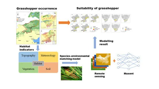
☘️Spatiotemporal Distribution and Main Influencing Factors of Potential in Two Steppe Types of Inner Mongolia, China
by Jing Guo, Longhui Lu, Yingying Dong, Wenjiang Huang, Bing Zhang et al

mdpi.com/2072-4292/15/3…

☘️Spatiotemporal Distribution and Main Influencing Factors of #Grasshopper Potential #Habitats in Two Steppe Types of Inner Mongolia, China by Jing Guo, Longhui Lu, Yingying Dong, Wenjiang Huang, Bing Zhang et al mdpi.com/2072-4292/15/3… #vegetation
account_circle
Remote Sensing MDPI(@RemoteSens_MDPI) 's Twitter Profile Photo

📑Discovering the under the Forest Using Machine Learning with Timing-Series Features of Images: Taking Baling Mountain in Jingzhou as an Example
by Yichuan Liu, Qingwu Hu, Shaohua Wang, Fengli Zou et al

mdpi.com/2072-4292/15/3…

📑Discovering the #AncientTomb under the Forest Using Machine Learning with Timing-Series Features of #Sentinel Images: Taking Baling Mountain in Jingzhou as an Example by Yichuan Liu, Qingwu Hu, Shaohua Wang, Fengli Zou et al mdpi.com/2072-4292/15/3… #Archaeology
account_circle
Remote Sensing MDPI(@RemoteSens_MDPI) 's Twitter Profile Photo

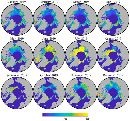
❄️Arctic Lead Detection from Chinese HY-2B Altimeter Data
by Wenqing Zhong, Maofei Jiang, Ke Xu and Yongjun Jia

mdpi.com/2072-4292/15/2…

❄️Arctic #SeaIce Lead Detection from Chinese HY-2B #Radar Altimeter Data by Wenqing Zhong, Maofei Jiang, Ke Xu and Yongjun Jia mdpi.com/2072-4292/15/2… #cryosphere
account_circle
Remote Sensing MDPI(@RemoteSens_MDPI) 's Twitter Profile Photo

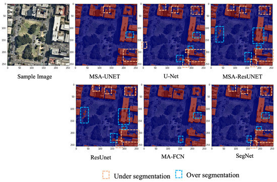
📢Multi-Scale Feature Map Aggregation and Supervised Domain Adaptation of Fully Networks for Urban Building
by Jagannath Aryal and Bipul Neupane

mdpi.com/2072-4292/15/2…

📢Multi-Scale Feature Map Aggregation and Supervised Domain Adaptation of Fully #Convolutional Networks for Urban Building #FootprintExtraction by Jagannath Aryal and Bipul Neupane mdpi.com/2072-4292/15/2… #imageprocessing
account_circle
Remote Sensing MDPI(@RemoteSens_MDPI) 's Twitter Profile Photo


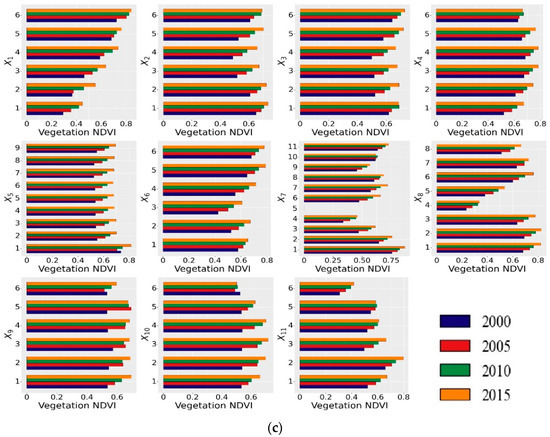
⛰Spatial–Temporal Evolution of Vegetation in Association with Climatic, Environmental and Anthropogenic Factors in the , China during 2000–2015: Quantitative Analysis Based on Geographical Detector Model

t.ly/-fOel

#MostCited ⛰Spatial–Temporal Evolution of Vegetation #NDVI in Association with Climatic, Environmental and Anthropogenic Factors in the #LoessPlateau, China during 2000–2015: Quantitative Analysis Based on Geographical Detector Model t.ly/-fOel #vegetation
account_circle
Remote Sensing MDPI(@RemoteSens_MDPI) 's Twitter Profile Photo


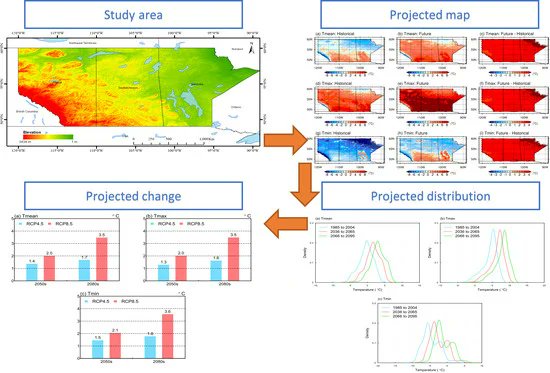
🌡Dynamical Downscaling of Variations over the Canadian Prairie Provinces under
by Xiong Zhou, Guohe Huang, Yongping Li, Qianguo Lin, Denghua Yan and Xiaojia He

mdpi.com/2072-4292/13/2…

#MostCited 🌡Dynamical Downscaling of #Temperature Variations over the Canadian Prairie Provinces under #ClimateChange by Xiong Zhou, Guohe Huang, Yongping Li, Qianguo Lin, Denghua Yan and Xiaojia He mdpi.com/2072-4292/13/2… #climate
account_circle
Remote Sensing MDPI(@RemoteSens_MDPI) 's Twitter Profile Photo


🌠On the Electron Temperature in the Topside as Seen by Swarm , Incoherent Scatter Radars, and the International Reference Ionosphere Model
by Alessio Pignalberi, Fabio Giannattasio, Vladimir Truhlik et al.

mdpi.com/2072-4292/13/2…

#MostCited 🌠On the Electron Temperature in the Topside #Ionosphere as Seen by Swarm #Satellites, Incoherent Scatter Radars, and the International Reference Ionosphere Model by Alessio Pignalberi, Fabio Giannattasio, Vladimir Truhlik et al. mdpi.com/2072-4292/13/2… #Ionosphere
account_circle
Remote Sensing MDPI(@RemoteSens_MDPI) 's Twitter Profile Photo


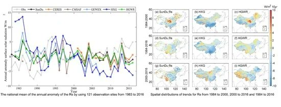
🌥Merging High-Resolution Surface Radiation Data with Sunshine Duration Observations over China from 1983 to 2017
by Fei Feng and Kaicun Wang

mdpi.com/2072-4292/13/4…

#MostCited 🌥Merging High-Resolution #Satellite Surface Radiation Data with #Meteorological Sunshine Duration Observations over China from 1983 to 2017 by Fei Feng and Kaicun Wang mdpi.com/2072-4292/13/4… #atmosphere
account_circle
Remote Sensing MDPI(@RemoteSens_MDPI) 's Twitter Profile Photo


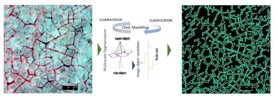
🛰An Object-Based Approach for Mapping Ice-Wedge Polygon Troughs from Very High Spatial Resolution Optical Imagery
by Chandi Witharana, Md Abul Ehsan Bhuiyan, Anna K. Liljedahl, Mikhail Kanevskiy et al.

mdpi.com/2072-4292/13/4…

#MostCited 🛰An Object-Based Approach for Mapping #Tundra Ice-Wedge Polygon Troughs from Very High Spatial Resolution Optical #Satellite Imagery by Chandi Witharana, Md Abul Ehsan Bhuiyan, Anna K. Liljedahl, Mikhail Kanevskiy et al. mdpi.com/2072-4292/13/4… #Arctic
account_circle
Remote Sensing MDPI(@RemoteSens_MDPI) 's Twitter Profile Photo


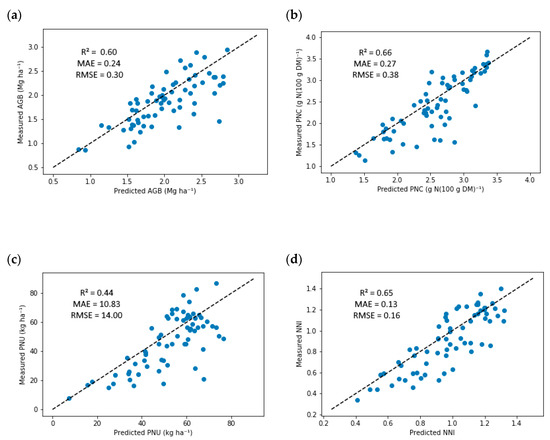
🌽Corn Status Diagnosis with an Innovative Multi-Parameter Circle Phenom Sensing System
by Cadan Cummings,Yuxin Miao, Gabriel Dias Paiao, Shujiang Kang and Fabián G. Fernández

mdpi.com/2072-4292/13/3…

#MostCited 🌽Corn #Nitrogen Status Diagnosis with an Innovative Multi-Parameter #Crop Circle Phenom Sensing System by Cadan Cummings,Yuxin Miao, Gabriel Dias Paiao, Shujiang Kang and Fabián G. Fernández mdpi.com/2072-4292/13/3… #agriculture
account_circle
Remote Sensing MDPI(@RemoteSens_MDPI) 's Twitter Profile Photo


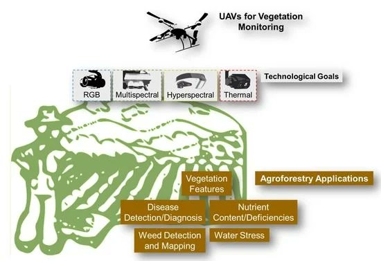
🌿 for Monitoring: Overview and Recent Scientific Contributions
by Ana I. de Castro, Yeyin Shi, Joe Mari Maja and Jose M. Peña

mdpi.com/2072-4292/13/1…

#MostCited 🌿#UAVs for #Vegetation Monitoring: Overview and Recent Scientific Contributions by Ana I. de Castro, Yeyin Shi, Joe Mari Maja and Jose M. Peña mdpi.com/2072-4292/13/1… #vegetation
account_circle
Remote Sensing MDPI(@RemoteSens_MDPI) 's Twitter Profile Photo


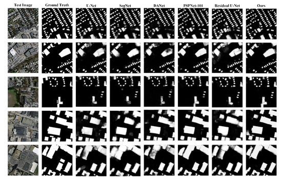
📝Self-Attention in Reconstruction Bias U-Net for of Building Rooftops in Optical Remote Sensing Images
by Ziyi Chen, Dilong Li, Wentao Fan, Haiyan Guan, Cheng Wang and Jonathan Li

mdpi.com/2072-4292/13/1…

#MostCited 📝Self-Attention in Reconstruction Bias U-Net for #SemanticSegmentation of Building Rooftops in Optical Remote Sensing Images by Ziyi Chen, Dilong Li, Wentao Fan, Haiyan Guan, Cheng Wang and Jonathan Li mdpi.com/2072-4292/13/1… #imageprocessing
account_circle
Remote Sensing MDPI(@RemoteSens_MDPI) 's Twitter Profile Photo


📢Automatic Detection of Inland Water Bodies along Tracks for Estimating Storage Variations in the Congo Basin
by Frédéric Frappart, Pierre Zeiger, Julie Betbeder, Valéry Gond, Régis Bellot et al.

mdpi.com/2072-4292/13/1…

#MostCited 📢Automatic Detection of Inland Water Bodies along #Altimetry Tracks for Estimating #SurfaceWater Storage Variations in the Congo Basin by Frédéric Frappart, Pierre Zeiger, Julie Betbeder, Valéry Gond, Régis Bellot et al. mdpi.com/2072-4292/13/1… #hydrology
account_circle