Nature Desai(@NatureDesai) 's Twitter Profileg
Nature Desai

@NatureDesai

CSE | AI/ML | IIT Guwahati | BPGC | Geography | Himalayas | Maps.

ID:1339575161410875394

calendar_today17-12-2020 14:16:52

858 Tweets

4,1K Followers

373 Following

Nature Desai(@NatureDesai) 's Twitter Profile Photo

New strategic road enters Aksai Chin from the North. It's the 3rd connectivity from Sinkiang, first two exist via Haji Langar and Qaratagh.
This connectivity will bypass the existing 300 km long Kangxiwar-Depsang route & reduce it to around 150 km.
Road building started late 2023

New strategic road enters Aksai Chin from the North. It's the 3rd connectivity from Sinkiang, first two exist via Haji Langar and Qaratagh. This connectivity will bypass the existing 300 km long Kangxiwar-Depsang route & reduce it to around 150 km. Road building started late 2023
account_circle
Nature Desai(@NatureDesai) 's Twitter Profile Photo

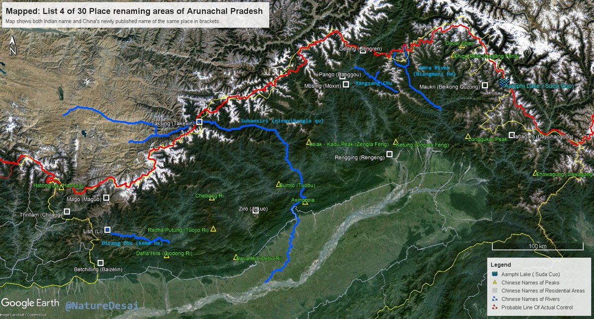
Mapped: All 30 named from the 4th list published by 🇨🇳's Ministry of Civil Affairs.

The list consists of One pass (Hatung La), Ten Residential areas (Villages), One Lake (The biggest lake in Arunachal), Four rivers, and Fourteen mountain peaks.

Is this a cognitive warfare?

Mapped: All 30 named from the 4th list published by 🇨🇳's Ministry of Civil Affairs. The list consists of One pass (Hatung La), Ten Residential areas (Villages), One Lake (The biggest lake in Arunachal), Four rivers, and Fourteen mountain peaks. Is this a cognitive warfare?
account_circle
Nature Desai(@NatureDesai) 's Twitter Profile Photo

Update:

In the Eastern Himalayas, progress on the alternate connectivity to the 'Tawang Bowl' from the Kameng Sector is also visible. They'll formally announce soon, I assume!

The strengthening of the Ground Lines of Communications along our frontier with Tibet continues.

Update: In the Eastern Himalayas, progress on the alternate connectivity to the 'Tawang Bowl' from the Kameng Sector is also visible. They'll formally announce soon, I assume! The strengthening of the Ground Lines of Communications along our frontier with Tibet continues.
account_circle
Nature Desai(@NatureDesai) 's Twitter Profile Photo

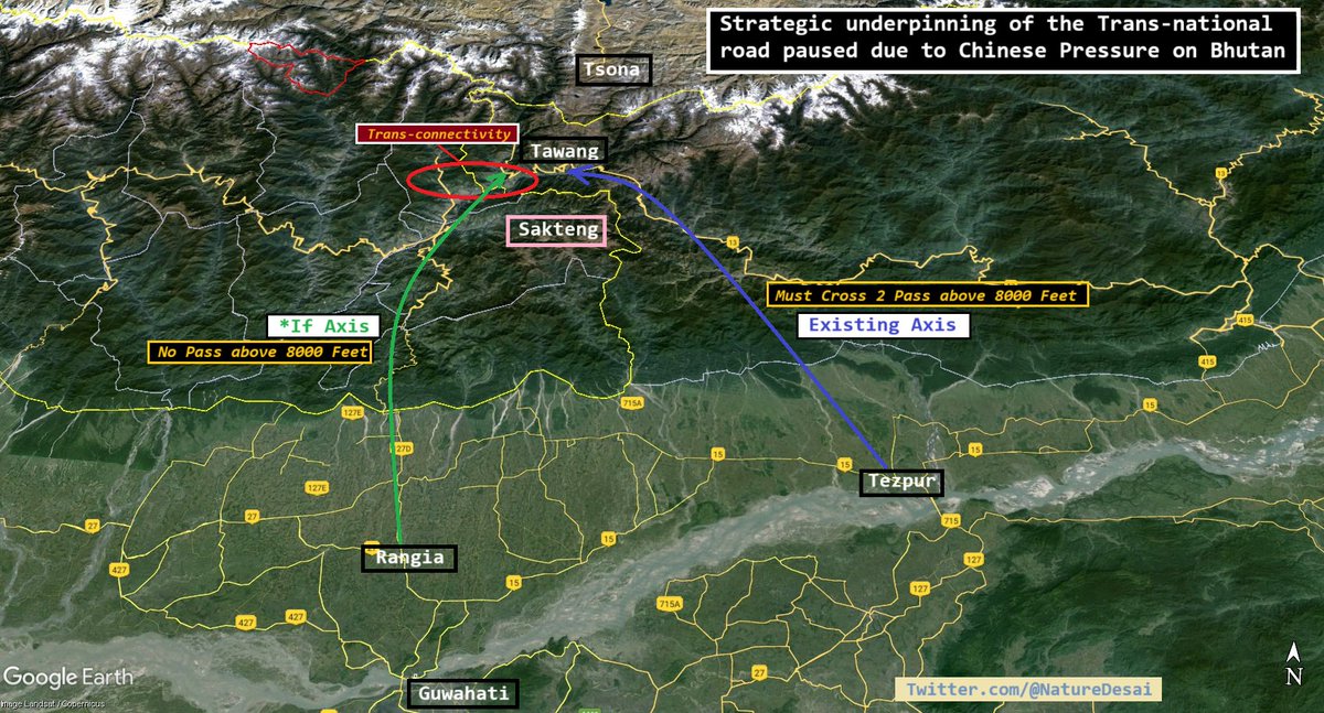
I explore the strategic importance of the road held back due to a 🇧🇹 request amidst boundary negotiations with 🇨🇳.
M1: Location of Bletting-Doksum Road Axis.
M2: How it provides & alt connectivity in case of hot conflict in the future. (In '62, some elements retreated via it.)

I explore the strategic importance of the road held back due to a 🇧🇹 request amidst boundary negotiations with 🇨🇳. M1: Location of Bletting-Doksum Road Axis. M2: How it provides & alt connectivity in case of hot conflict in the future. (In '62, some elements retreated via it.)
account_circle
Nature Desai(@NatureDesai) 's Twitter Profile Photo

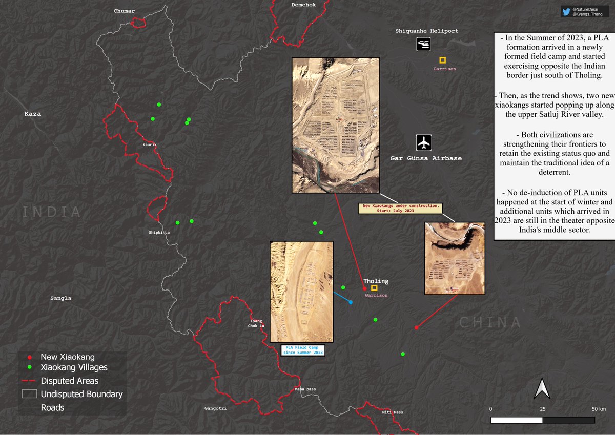
As reports suggest, one might think of the reasons for 🇮🇳 move to strengthen her positions in the middle sector by streamlining command structure & rationalizing force levels. Is it new infrastructure building and increased force levels of PLA in Zanda in comparison to the past?

As reports suggest, one might think of the reasons for 🇮🇳 move to strengthen her positions in the middle sector by streamlining command structure & rationalizing force levels. Is it new infrastructure building and increased force levels of PLA in Zanda in comparison to the past?
account_circle
Nature Desai(@NatureDesai) 's Twitter Profile Photo

Videos show forceful behaviour with monks by 🇨🇳 due to new dam?

Yena Pal Tashi Lhatse monastery of Yache bordering Yangbuting village along the Dri Chu (Yangtse), 15 km as the crow flies (60 km by road) from Derge of Kham, Tibet.

Even in Nov 1957, 🇨🇳 arrested monks from here!

Videos show forceful behaviour with monks by 🇨🇳 due to new dam? Yena Pal Tashi Lhatse monastery of Yache bordering Yangbuting village along the Dri Chu (Yangtse), 15 km as the crow flies (60 km by road) from Derge of Kham, Tibet. Even in Nov 1957, 🇨🇳 arrested monks from here!
account_circle
Nature Desai(@NatureDesai) 's Twitter Profile Photo

> It is an undefined frontier. For long 🇮🇳 nomads were not allowed to graze there. 🇮🇳 army restored grazing rights and helped re-establish 🇮🇳 nomadic presence after years.
More: x.com/NatureDesai/st…

> Traditional customary boundary lies at Chang la, 20 km beyond current LAC.

> It is an undefined frontier. For long 🇮🇳 nomads were not allowed to graze there. 🇮🇳 army restored grazing rights and helped re-establish 🇮🇳 nomadic presence after years. More: x.com/NatureDesai/st… > Traditional customary boundary lies at Chang la, 20 km beyond current LAC.
account_circle
Nature Desai(@NatureDesai) 's Twitter Profile Photo

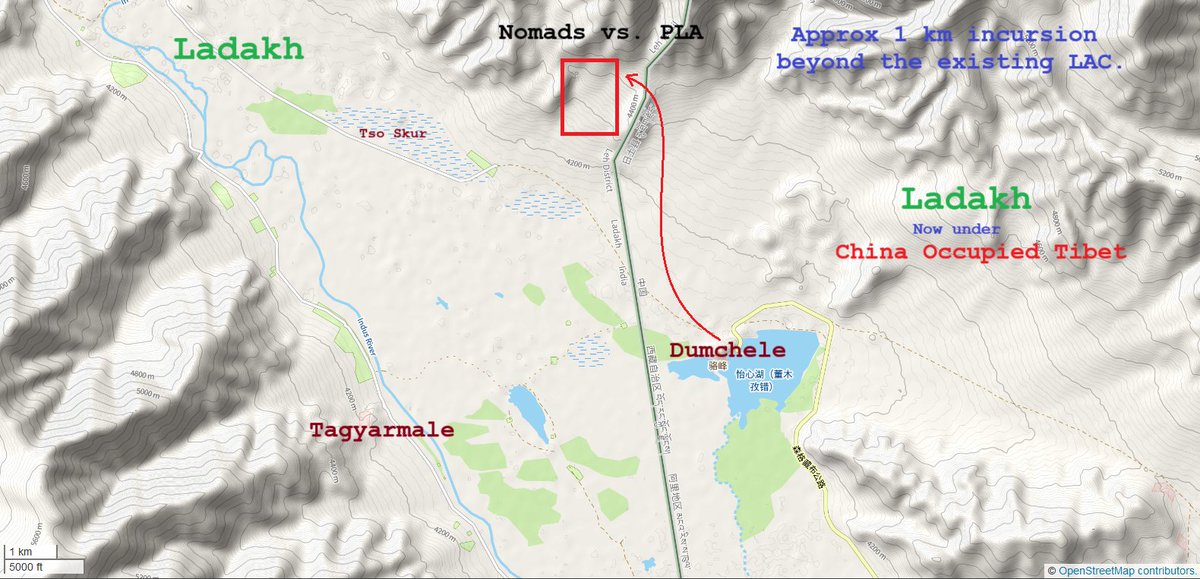
Video geolocated near LAC @ 33.1189°, 79.1415°.

This time 🇨🇳 PLA bullied nomads some 1 km inside 🇮🇳 administered area.

Interesting that they crossed their own claim line too!

I remember, in Qi Fabao vs. ITBP officer video, our folks were inside their administered Ladakhi area

Video geolocated near LAC @ 33.1189°, 79.1415°. This time 🇨🇳 PLA bullied nomads some 1 km inside 🇮🇳 administered area. Interesting that they crossed their own claim line too! I remember, in Qi Fabao vs. ITBP officer video, our folks were inside their administered Ladakhi area
account_circle
Nature Desai(@NatureDesai) 's Twitter Profile Photo

Someone seems to have dammed the Mapcha Tsangpo - known as Ghaghara (in UP 🇮🇳) or Karnali (in Nepal 🇳🇵) or Saryu (in Ayodhya/Awadh).

Interesting optics from our northern neighbour. What can you do even as we've dammed your sacred rivers; be it Sindhu, Sutlej, Siang or now Saryu.

Someone seems to have dammed the Mapcha Tsangpo - known as Ghaghara (in UP 🇮🇳) or Karnali (in Nepal 🇳🇵) or Saryu (in Ayodhya/Awadh). Interesting optics from our northern neighbour. What can you do even as we've dammed your sacred rivers; be it Sindhu, Sutlej, Siang or now Saryu.
account_circle
Nature Desai(@NatureDesai) 's Twitter Profile Photo

Update:
Drone image showing the xiaokang in Nagdoh bowl of the Shao Chu valley less than 3 miles from Bum La & less than 5 miles from Chumi Gyatse.

Coordinates: 27.76431° N, 91.90842° E
Elevation: Around 4100m

Update: Drone image showing the xiaokang in Nagdoh bowl of the Shao Chu valley less than 3 miles from Bum La & less than 5 miles from Chumi Gyatse. Coordinates: 27.76431° N, 91.90842° E Elevation: Around 4100m
account_circle
Kyang Thang རྐྱང་ཐང་(@Kyangs_Thang) 's Twitter Profile Photo

ལོ་གསར་བཀྲ་ཤིས་བདེ་ལེགས Losar Tashi Delek

1) Today marks the beginning of Ladakhi New Year. Traditionally, Tibetan calendar dictates that Losar be celebrated after the twelfth month, towards the END of winter.

So what happened in Ladakh? It has an interesting bit of history🧵

ལོ་གསར་བཀྲ་ཤིས་བདེ་ལེགས Losar Tashi Delek 1) Today marks the beginning of Ladakhi New Year. Traditionally, Tibetan calendar dictates that Losar be celebrated after the twelfth month, towards the END of winter. So what happened in Ladakh? It has an interesting bit of history🧵
account_circle
Nature Desai(@NatureDesai) 's Twitter Profile Photo

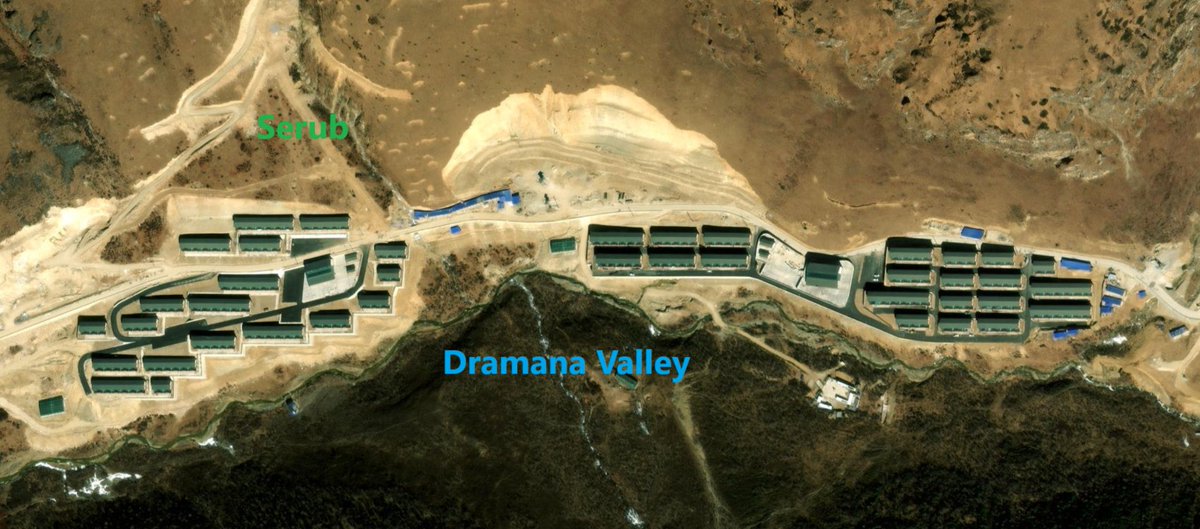
All🇨🇳 villages in western 🇧🇹 & the changed status quo

1. Amo chu valley - Pangda village cluster
2. Langmarpo chu valley
3. Shakhatoe valley village cluster
4. Dramana valley xiaokang

Let's see if 🇧🇹 let go these valleys in new border demarcation

More @ timesofindia.indiatimes.com/india/how-chin…

All🇨🇳 villages in western 🇧🇹 & the changed status quo 1. Amo chu valley - Pangda village cluster 2. Langmarpo chu valley 3. Shakhatoe valley village cluster 4. Dramana valley xiaokang Let's see if 🇧🇹 let go these valleys in new border demarcation More @ timesofindia.indiatimes.com/india/how-chin…
account_circle