NWS Detroit(@NWSDetroit) 's Twitter Profileg
NWS Detroit

@NWSDetroit

Official Twitter account for the National Weather Service Detroit/Pontiac. Details: https://t.co/DMhR7TICZ5

ID:596438734

linkhttp://weather.gov/detroit calendar_today01-06-2012 12:53:33

16,7K Tweets

33,8K Followers

158 Following

NWS Detroit(@NWSDetroit) 's Twitter Profile Photo

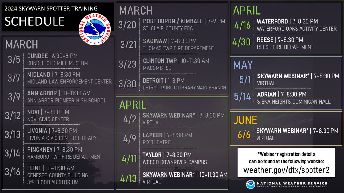
Skywarn Spotter training classes continue with a handful of opportunities remaining this spring, including one at 7pm this evening at the WCCCD Downriver campus in Taylor. Classes are free and open to all to attend. weather.gov/dtx/spotter2

Skywarn Spotter training classes continue with a handful of opportunities remaining this spring, including one at 7pm this evening at the @WCCCDistrict Downriver campus in Taylor. Classes are free and open to all to attend. weather.gov/dtx/spotter2 #miwx
account_circle
NWS Detroit(@NWSDetroit) 's Twitter Profile Photo

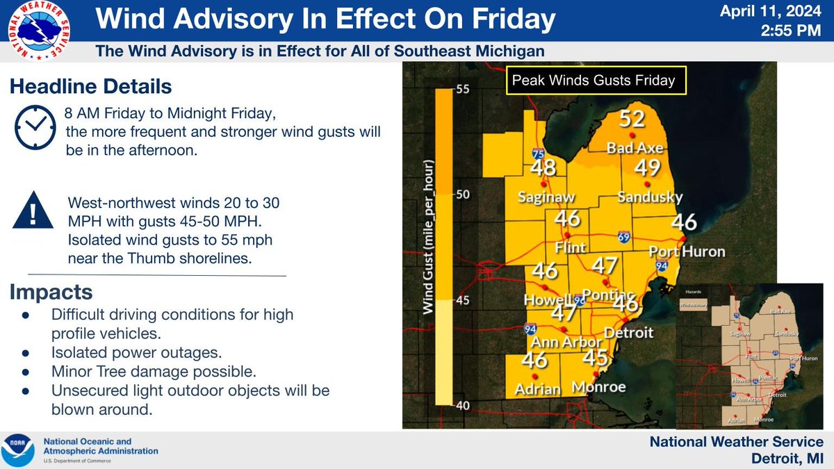
A wind advisory has been issued for Friday and Friday evening for all of southeast Michigan. West-northwest wind gusts of 45-50 mph expected, with isolated gusts up to 55 mph possible near the Thumb shorelines.

A wind advisory has been issued for Friday and Friday evening for all of southeast Michigan. West-northwest wind gusts of 45-50 mph expected, with isolated gusts up to 55 mph possible near the Thumb shorelines.
account_circle
NWS Detroit(@NWSDetroit) 's Twitter Profile Photo

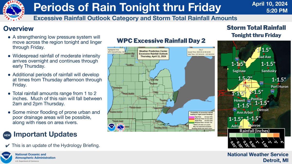
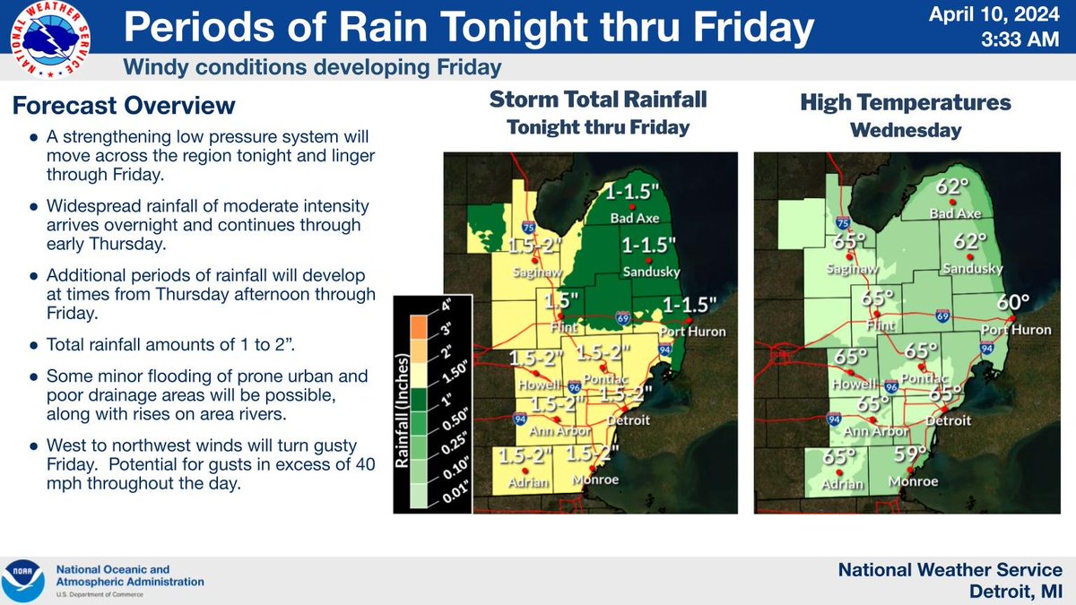
Periods of rain will continue to develop across southeast Michigan through Friday. Rainfall totals of 1 to 2 inches. Some minor flooding of prone urban and poor drainage areas will be possible, along with rises on area rivers.

Periods of rain will continue to develop across southeast Michigan through Friday. Rainfall totals of 1 to 2 inches. Some minor flooding of prone urban and poor drainage areas will be possible, along with rises on area rivers. #miwx
account_circle
NWS Detroit(@NWSDetroit) 's Twitter Profile Photo

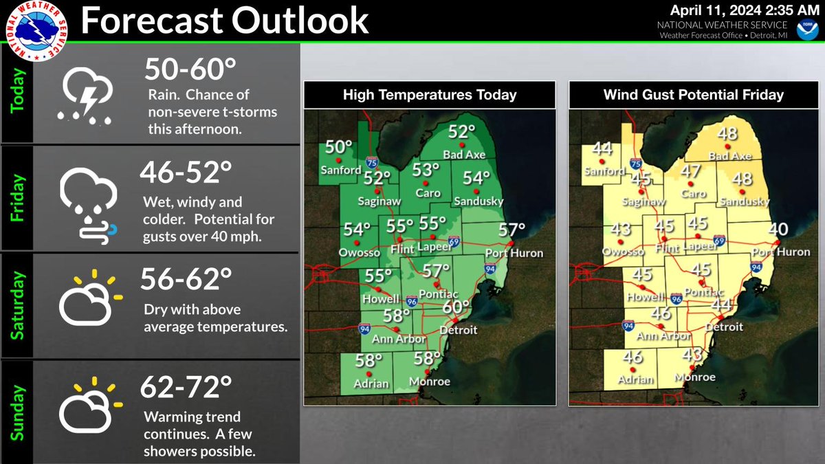
Wet conditions today through Friday, with periods of rain at times. Total rainfall amounts of 1 to 2 inches. Chance for a few non-severe thunderstorms this afternoon and early evening. Turning windy and colder Friday. Potential for northwest winds to gust over 40 mph.

Wet conditions today through Friday, with periods of rain at times. Total rainfall amounts of 1 to 2 inches. Chance for a few non-severe thunderstorms this afternoon and early evening. Turning windy and colder Friday. Potential for northwest winds to gust over 40 mph. #miwx
account_circle
NWS Detroit(@NWSDetroit) 's Twitter Profile Photo

Widespread rain arrives overnight and continues into Thursday. Periods of rain will continue Thursday night and Friday. Rainfall totals of 1 to 2 inches. Turning windy and much colder Friday. Potential for wind gusts in excess of 40 mph throughout the day.

Widespread rain arrives overnight and continues into Thursday. Periods of rain will continue Thursday night and Friday. Rainfall totals of 1 to 2 inches. Turning windy and much colder Friday. Potential for wind gusts in excess of 40 mph throughout the day. #miwx
account_circle
NWS Detroit(@NWSDetroit) 's Twitter Profile Photo

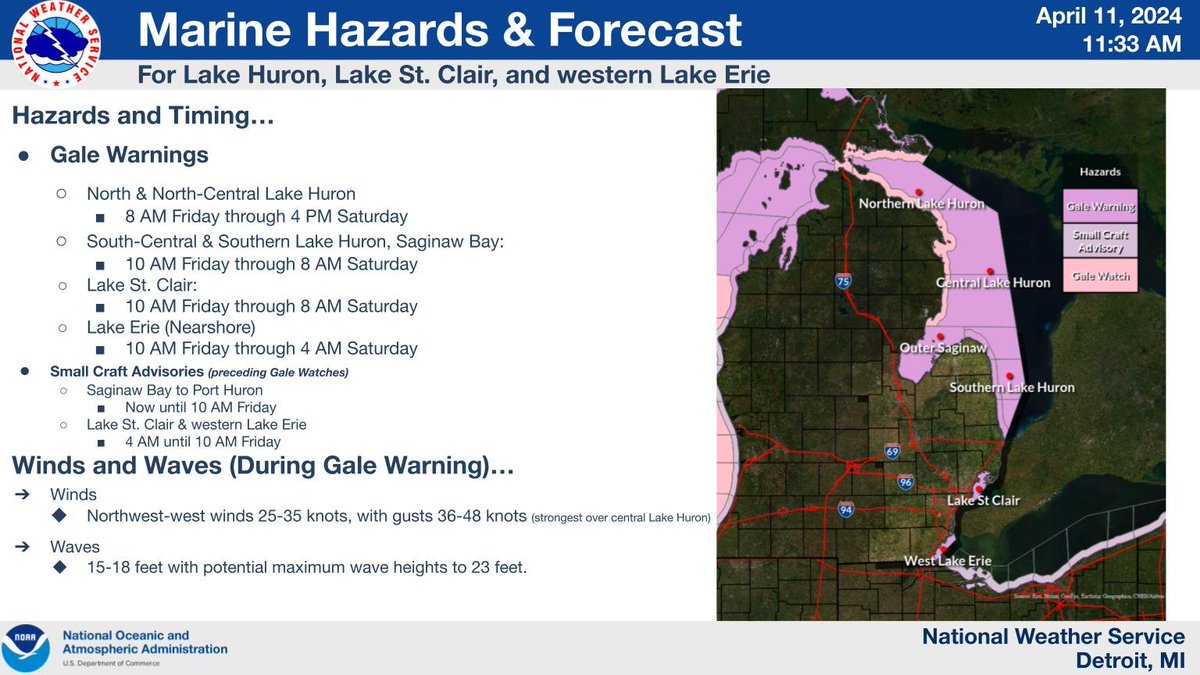
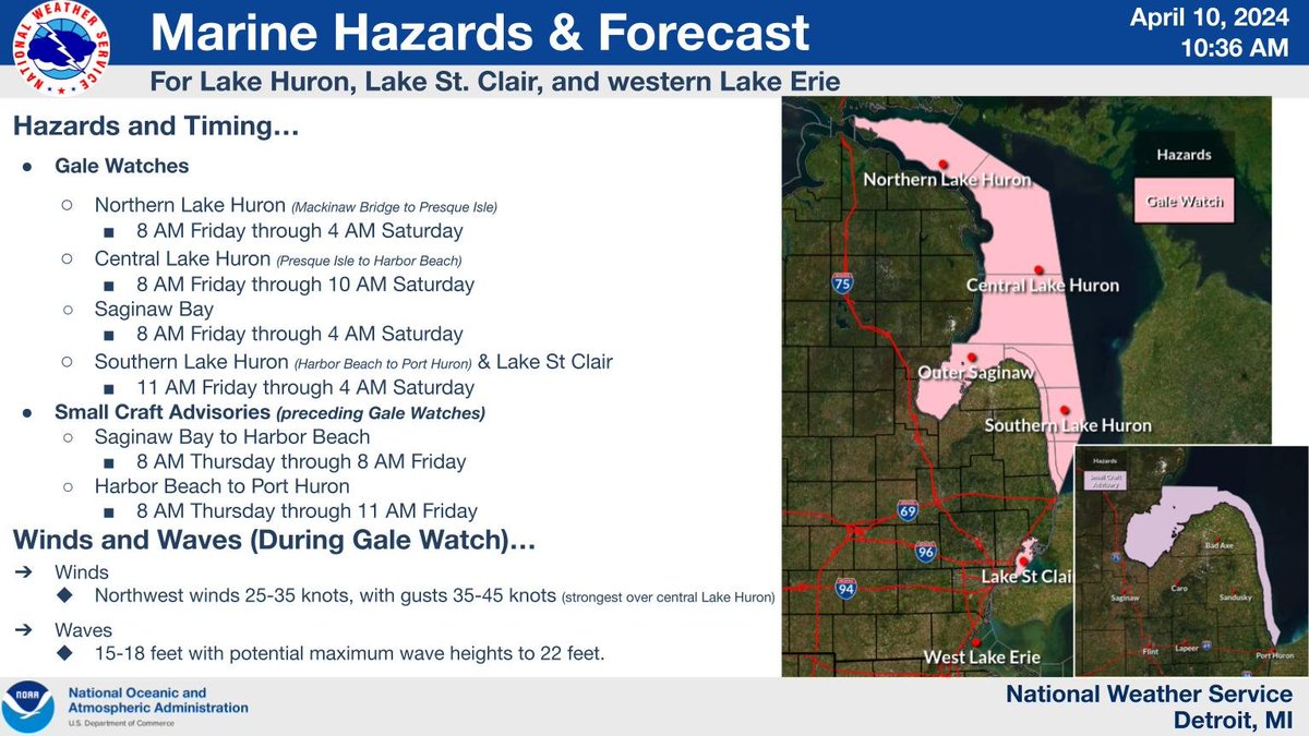
Small Craft Advisories are in effect around the Thumb Thursday. Gale Watches are up for all of Lake Huron open waters, the Thumb nearshore waters, and Lake St Clair Friday into Saturday morning.

Small Craft Advisories are in effect around the Thumb Thursday. Gale Watches are up for all of Lake Huron open waters, the Thumb nearshore waters, and Lake St Clair Friday into Saturday morning. #miwx
account_circle
NWS Detroit(@NWSDetroit) 's Twitter Profile Photo

Mild ๐Ÿ™ด dry today. Wet conditions tonight through Friday. Rain totals of 1 to 2 inches. Turning windy and colder Friday. Gusts greater than 40 mph possible.

Mild ๐Ÿ™ด dry today. Wet conditions tonight through Friday. Rain totals of 1 to 2 inches. Turning windy and colder Friday. Gusts greater than 40 mph possible. #miwx
account_circle
NWS Detroit(@NWSDetroit) 's Twitter Profile Photo

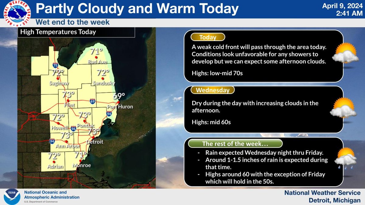
Widespread rain will move into the area Wednesday night and will persist off and on into the day Friday. Gusty winds, possibly over 40 MPH, are possible on Friday.

Widespread rain will move into the area Wednesday night and will persist off and on into the day Friday. Gusty winds, possibly over 40 MPH, are possible on Friday. #miwx
account_circle
NWS Detroit(@NWSDetroit) 's Twitter Profile Photo

Quiet weather today with a dry cold front passing through the region. Another warm day with temps back into the 70s. A large low pressure system will then move slowly through the region the second half of the week bringing widespread rainfall Wed night thru Fri.

Quiet weather today with a dry cold front passing through the region. Another warm day with temps back into the 70s. A large low pressure system will then move slowly through the region the second half of the week bringing widespread rainfall Wed night thru Fri. #miwx
account_circle
NWS Detroit(@NWSDetroit) 's Twitter Profile Photo

Temperatures dropped 3.8 F here at the office during the solar eclipse, but have quickly rebounded back to 70 degrees! The rest of the evening will be mild and clear.

account_circle
NOAA Great Lakes Environmental Research Laboratory(@NOAA_GLERL) 's Twitter Profile Photo

Itโ€™s Eclipse Day! ๐Ÿ˜Ž This will be a spectacular phenomenon all over the region, but & are at the center of the action, as the path of totality almost entirely covers them both!

nesdis.noaa.gov/events/noaa-ceโ€ฆ

๐Ÿ“ท@nasa Eclipse

Itโ€™s Eclipse Day! ๐Ÿ˜Ž This will be a spectacular phenomenon all over the #GreatLakes region, but #LakeErie & #LakeOntario are at the center of the action, as the path of totality almost entirely covers them both! nesdis.noaa.gov/events/noaa-ceโ€ฆ ๐Ÿ“ท@nasa #GreatLakesEclipse #EclipseDay2024
account_circle
NWS Detroit(@NWSDetroit) 's Twitter Profile Photo

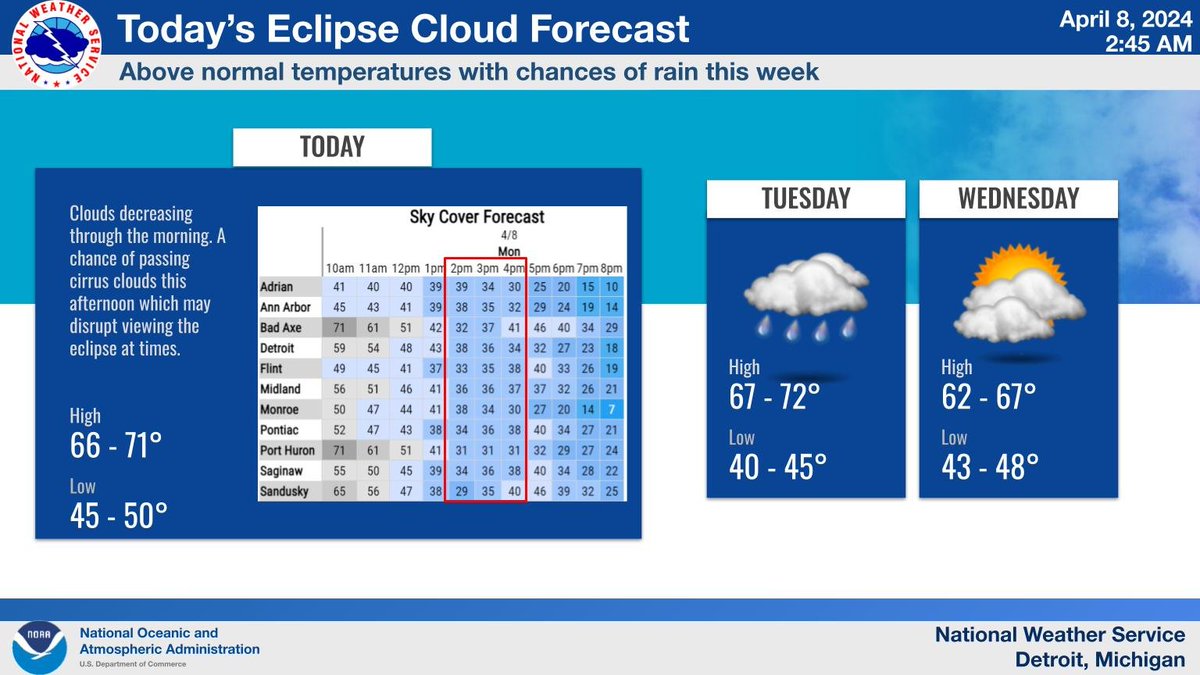
Morning clouds will mostly clear out by this afternoon but there is a chance of some passing cirrus clouds this afternoon which may disrupt viewing the eclipse at times. Rest of the week will feature above normal temperatures mainly in the 60s with a couple chances of rain.

Morning clouds will mostly clear out by this afternoon but there is a chance of some passing cirrus clouds this afternoon which may disrupt viewing the eclipse at times. Rest of the week will feature above normal temperatures mainly in the 60s with a couple chances of rain. #miwx
account_circle
NWS Weather Prediction Center(@NWSWPC) 's Twitter Profile Photo

[4/7/2024]

Updated Key Messages for tomorrow's total solar eclipse and cloud cover forecast are available. High clouds spanning across parts of the totality path are likely, but may not completely obscure the eclipse. For local forecasts visit weather.gov.

[4/7/2024] Updated Key Messages for tomorrow's total solar eclipse and cloud cover forecast are available. High clouds spanning across parts of the totality path are likely, but may not completely obscure the eclipse. For local forecasts visit weather.gov.
account_circle
NWS Detroit(@NWSDetroit) 's Twitter Profile Photo

Sunny skies to start the day turn cloudier through the afternoon with the next chance of rain arriving tonight. Clouds will be decreasing Monday morning into the afternoon and how fast they clear out will determine how well the eclipse can be seen.

Sunny skies to start the day turn cloudier through the afternoon with the next chance of rain arriving tonight. Clouds will be decreasing Monday morning into the afternoon and how fast they clear out will determine how well the eclipse can be seen. #miwx
account_circle
NWS Detroit(@NWSDetroit) 's Twitter Profile Photo

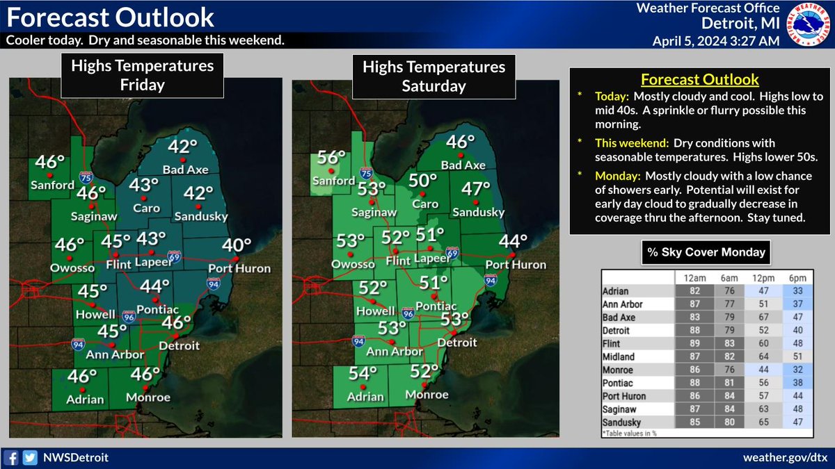
Dry and seasonable conditions thru Sunday. Chance of rain Sun night, with lingering early day clouds gradually decreasing coverage Monday. Pace of this clearing will determines the degree of visibility for the upcoming eclipse. Continue to monitor the forecast.

Dry and seasonable conditions thru Sunday. Chance of rain Sun night, with lingering early day clouds gradually decreasing coverage Monday. Pace of this clearing will determines the degree of visibility for the upcoming eclipse. Continue to monitor the forecast. #miwx
account_circle
NWS Detroit(@NWSDetroit) 's Twitter Profile Photo

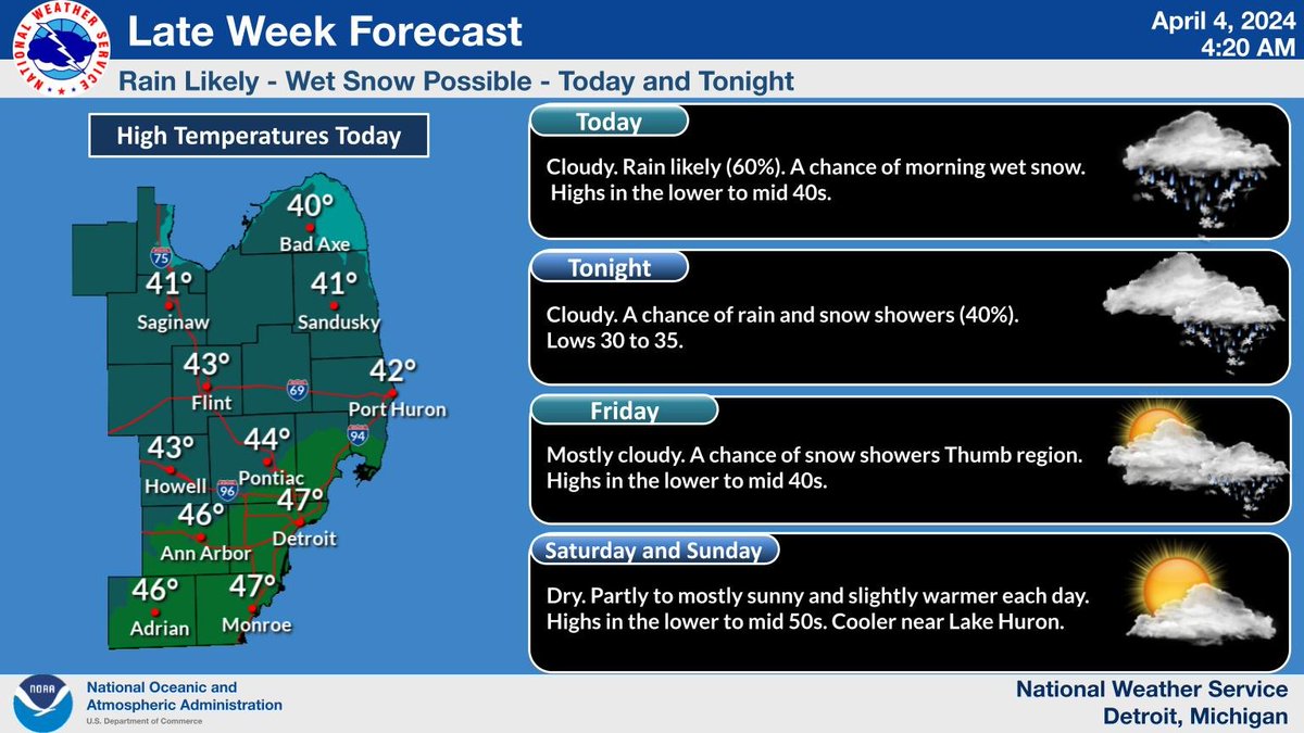
Weather today will be cloudy with rain likely (60%). There is a chance of morning wet snow. Highs in the lower to mid 40s. Cloudy tonight with a chance of rain and snow showers (40%). Lows 30 to 35. Mostly cloudy Friday. A chance of snow showers in the Thumb region.

Weather today will be cloudy with rain likely (60%). There is a chance of morning wet snow. Highs in the lower to mid 40s. Cloudy tonight with a chance of rain and snow showers (40%). Lows 30 to 35. Mostly cloudy Friday. A chance of snow showers in the Thumb region. #Miwx
account_circle
NWS Detroit(@NWSDetroit) 's Twitter Profile Photo

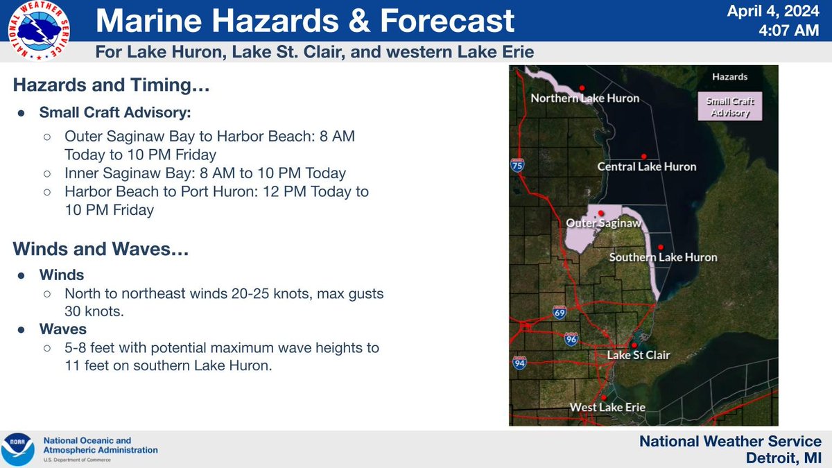
A Small Craft Advisory is in effect for Saginaw Bay and the Lake Huron nearshore waters from Port Austin to Port Huron.

A Small Craft Advisory is in effect for Saginaw Bay and the Lake Huron nearshore waters from Port Austin to Port Huron. #miwx
account_circle