NWS Buffalo(@NWSBUFFALO) 's Twitter Profileg
NWS Buffalo

@NWSBUFFALO

Official Twitter Account for National Weather Service Buffalo New York. Details: http://t.co/KKTK7cZlhK

ID:982762350

linkhttp://www.weather.gov/buf calendar_today01-12-2012 15:32:05

21,4K Tweets

46,2K Followers

242 Following

NWS Buffalo(@NWSBUFFALO) 's Twitter Profile Photo

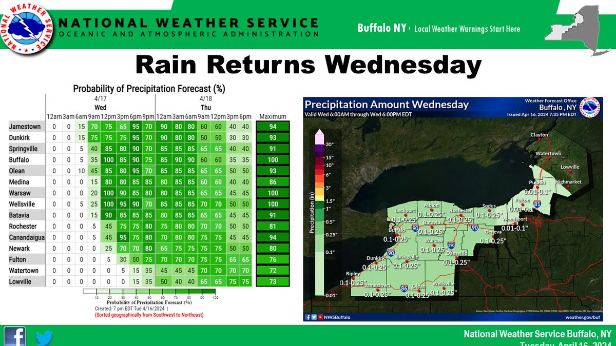
April showers bring May flowers...

Rain makes a return Wed, with showers arriving in Western NY by mid-late morning, then spreading to areas east of Lk Ontario in the afternoon. Periods of showers will continue thru Friday, but there will also be windows of rain free time.

April showers bring May flowers... Rain makes a return Wed, with showers arriving in Western NY by mid-late morning, then spreading to areas east of Lk Ontario in the afternoon. Periods of showers will continue thru Friday, but there will also be windows of rain free time. #nywx
account_circle
NWS Buffalo(@NWSBUFFALO) 's Twitter Profile Photo

It will be a dry and sunny day across the eastern Great Lakes region. You can expect daytime highs to range from the low to mid 50s east of Lake Ontario to the low to mid 60s across much of western NY. The upper 50s are expected across the higher terrain of western NY.

It will be a dry and sunny day across the eastern Great Lakes region. You can expect daytime highs to range from the low to mid 50s east of Lake Ontario to the low to mid 60s across much of western NY. The upper 50s are expected across the higher terrain of western NY.
account_circle
NWS Buffalo(@NWSBUFFALO) 's Twitter Profile Photo

(2/2) You can also choose an option to display the SkewT plot which shows different weather variables measured!

The balloon was also captured in a photo with the moon as well! Images for both the balloon & webpage below:

(2/2) You can also choose an option to display the SkewT plot which shows different weather variables measured! The balloon was also captured in a photo with the moon as well! Images for both the balloon & webpage below:
account_circle
NWS Buffalo(@NWSBUFFALO) 's Twitter Profile Photo

(1/2) This evening's weather balloon can be tracked at: sondehub.org along with weather balloons from around the world! Different overlays can be selected, such as radar & satellite.

account_circle
NWS Buffalo(@NWSBUFFALO) 's Twitter Profile Photo

Outside of a few light showers up across the North Country today, expect mainly dry weather through tomorrow. More unsettled weather on the way later this week, before a cooler pattern emerges by the weekend and likely persists into next week.

Outside of a few light showers up across the North Country today, expect mainly dry weather through tomorrow. More unsettled weather on the way later this week, before a cooler pattern emerges by the weekend and likely persists into next week. #NYwx
account_circle
NWS Buffalo(@NWSBUFFALO) 's Twitter Profile Photo

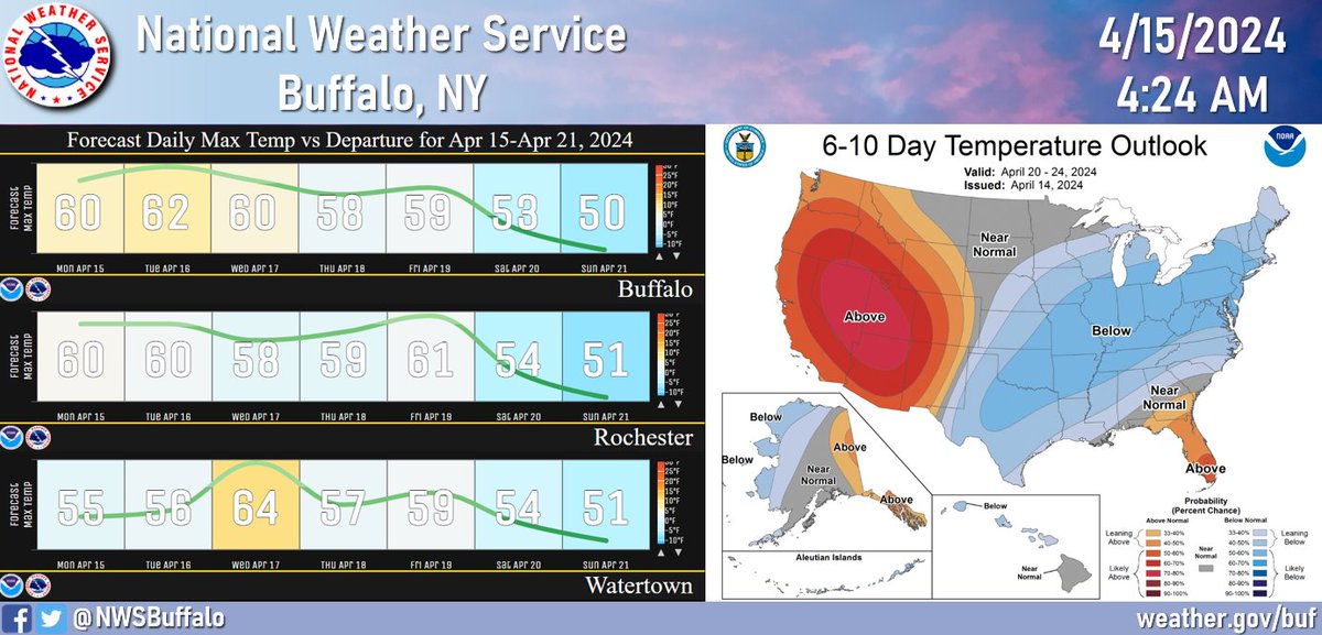
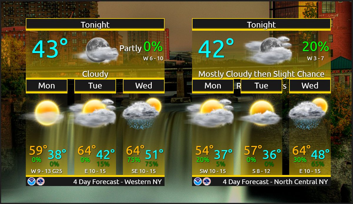
Pleasant weather through most of Tuesday night is expected across the entire area, along with above normal temperatures through mid week. Wet weather returns for the second half of the week.

Details below and at: weather.gov/buf

Pleasant weather through most of Tuesday night is expected across the entire area, along with above normal temperatures through mid week. Wet weather returns for the second half of the week. #Buffalo #Rochester #Watertown Details below and at: weather.gov/buf
account_circle
NWS Buffalo(@NWSBUFFALO) 's Twitter Profile Photo

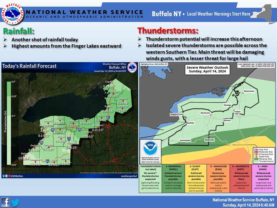
Another round of rain on tap for today with breezy conditions. There is also a Marginal Risk for severe weather across the western Southern Tier for this afternoon into the early evening hours. The main threat will be damaging wind gusts, with a lesser threat for large hail.

Another round of rain on tap for today with breezy conditions. There is also a Marginal Risk for severe weather across the western Southern Tier for this afternoon into the early evening hours. The main threat will be damaging wind gusts, with a lesser threat for large hail.
account_circle
NWS Buffalo(@NWSBUFFALO) 's Twitter Profile Photo

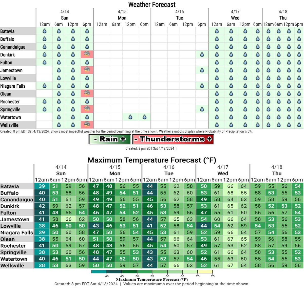
Showers with some thunderstorms for Sunday, followed by a few drier days to start the new work week. Warmer than normal temperatures return Sunday through much of the new week. Showers/rain returns again for the middle of the week.

Details below and at: weather.gov/buf

Showers with some thunderstorms for Sunday, followed by a few drier days to start the new work week. Warmer than normal temperatures return Sunday through much of the new week. Showers/rain returns again for the middle of the week. Details below and at: weather.gov/buf
account_circle
NWS Buffalo(@NWSBUFFALO) 's Twitter Profile Photo

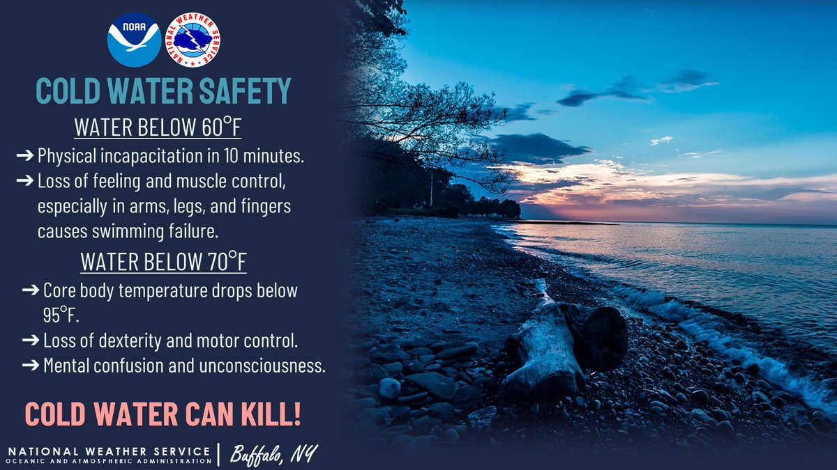
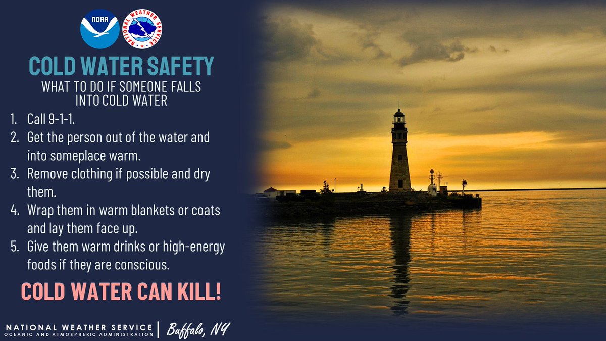
Plunging into cold water can be dangerous if you aren’t prepared. Do you know what to do if you or someone nearby falls into cold water?

Plunging into cold water can be dangerous if you aren’t prepared. Do you know what to do if you or someone nearby falls into cold water? #ColdWaterSafety
account_circle
NWS Buffalo(@NWSBUFFALO) 's Twitter Profile Photo

While we will finally start to dry out from west to east, it will still feel rather raw and blustery out there today. Wind Advisories remain in effect until this afternoon for all areas except Lewis and Jefferson counties.

While we will finally start to dry out from west to east, it will still feel rather raw and blustery out there today. Wind Advisories remain in effect until this afternoon for all areas except Lewis and Jefferson counties. #NYwx
account_circle
NWS Buffalo(@NWSBUFFALO) 's Twitter Profile Photo

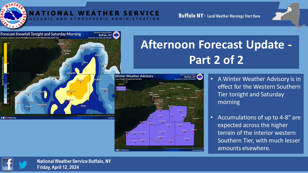
Afternoon Forecast Update, Part 2 of 2: A Winter Weather Advisory is also up for the Southern Tier, where snow could accumulate 4 to 8 inches over the higher terrain inland from Lake Erie. Note: maximum amounts in the graphic are actually only right around 8 inches - NOT 12'.

Afternoon Forecast Update, Part 2 of 2: A Winter Weather Advisory is also up for the Southern Tier, where snow could accumulate 4 to 8 inches over the higher terrain inland from Lake Erie. Note: maximum amounts in the graphic are actually only right around 8 inches - NOT 12'.
account_circle
NWS Buffalo(@NWSBUFFALO) 's Twitter Profile Photo

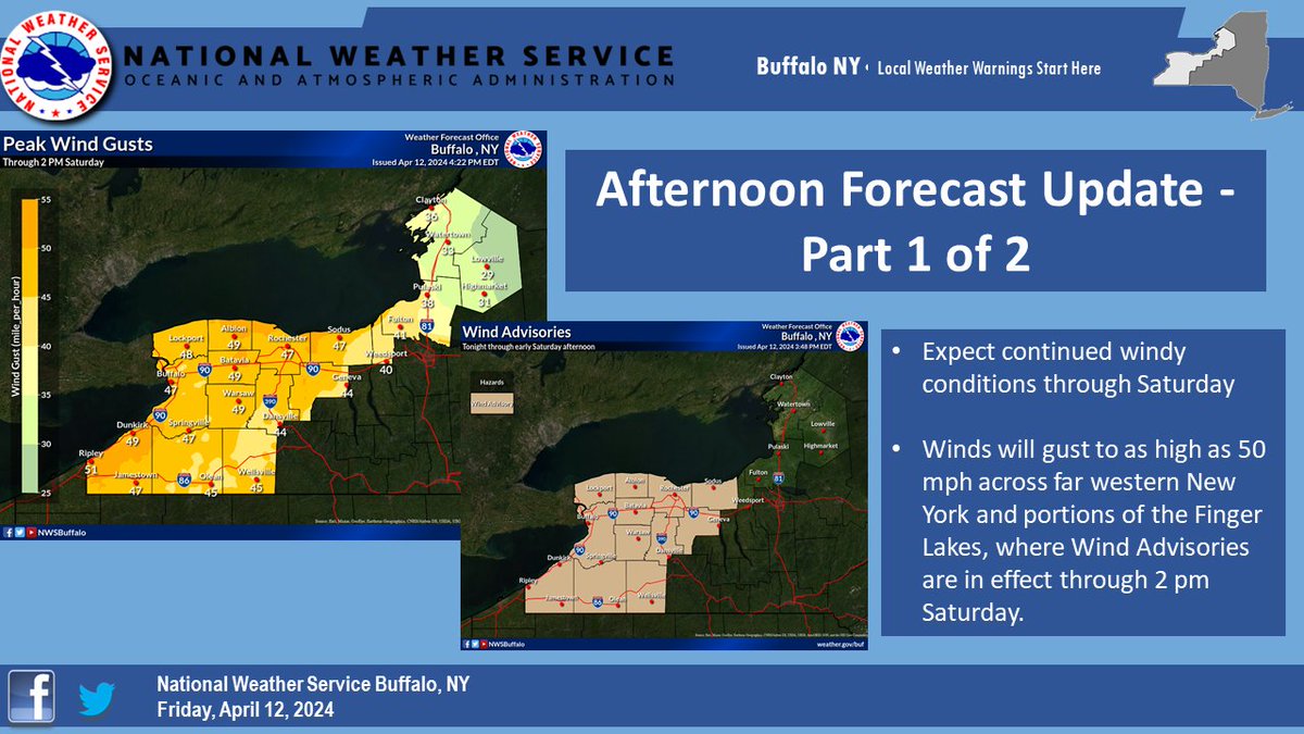
Afternoon Forecast Update, Part 1 of 2: Unsettled weather will continue tonight and Saturday. Wind Advisories are in effect through 2 pm Saturday for Western New York and much of the Finger Lakes, where westerly wind gusts to as high as 50 mph are expected.

Afternoon Forecast Update, Part 1 of 2: Unsettled weather will continue tonight and Saturday. Wind Advisories are in effect through 2 pm Saturday for Western New York and much of the Finger Lakes, where westerly wind gusts to as high as 50 mph are expected.
account_circle
NWS Buffalo(@NWSBUFFALO) 's Twitter Profile Photo

All week we’ve said dress for the water temperature, NOT the air temperature. But where can you find the water temperature? Check out our Great Lakes Portal for observations on Lake Erie and other Great Lakes!
weather.gov/greatlakes/glo…

account_circle
NWS Buffalo(@NWSBUFFALO) 's Twitter Profile Photo

A wind advisory has been issued for wind gusts up to 50 mph. Some tree limbs could blow down and a few power outages may result.

A wind advisory has been issued for wind gusts up to 50 mph. Some tree limbs could blow down and a few power outages may result. #NYwx
account_circle
NWS Buffalo(@NWSBUFFALO) 's Twitter Profile Photo

Wet soggy conditions continue today and turning colder behind the cold front. It will also be quite breezy to windy. NYwx

Wet soggy conditions continue today and turning colder behind the cold front. It will also be quite breezy to windy. NYwx
account_circle
NWS Buffalo(@NWSBUFFALO) 's Twitter Profile Photo

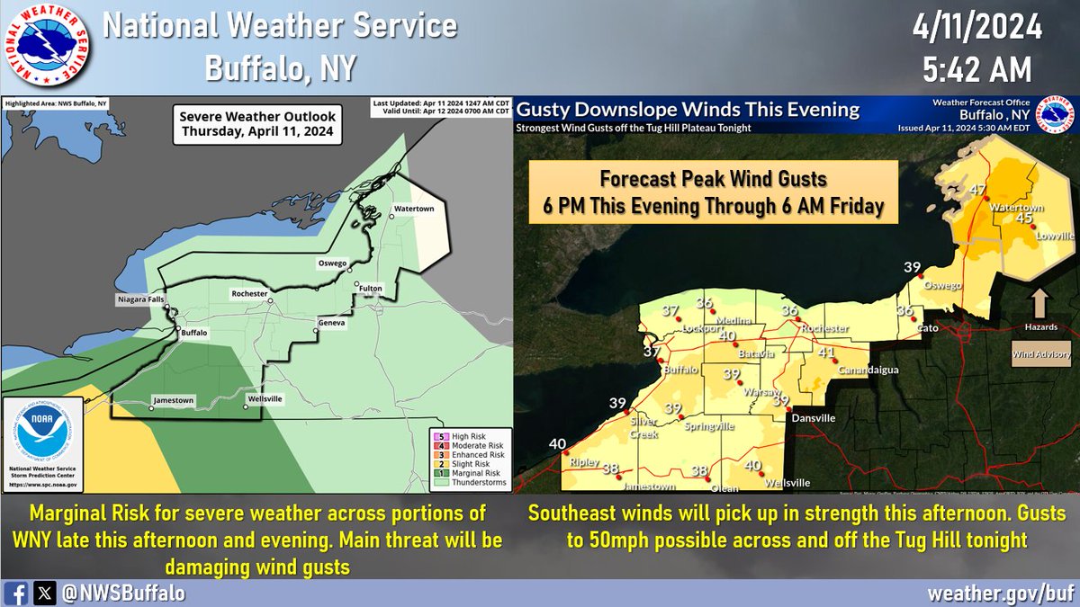
The main story through Friday night will be the wind and rain. For later today into tonight:
🌬️ Southeast winds across the region will be strongest across the hilltops and typical downslope areas, especially off the Tug Hill Plateau
⛈️ Marginal risk for severe storms across WNY

The main story through Friday night will be the wind and rain. For later today into tonight: 🌬️ Southeast winds across the region will be strongest across the hilltops and typical downslope areas, especially off the Tug Hill Plateau ⛈️ Marginal risk for severe storms across WNY
account_circle
NWS Buffalo(@NWSBUFFALO) 's Twitter Profile Photo

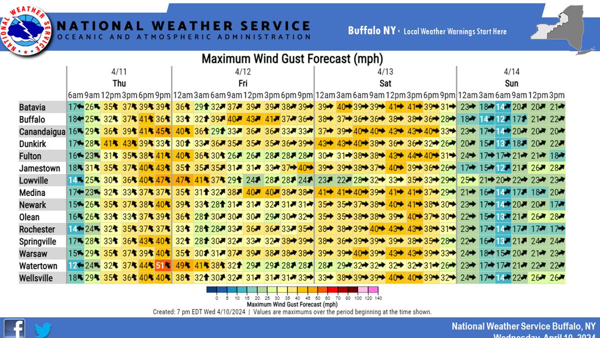
In addition to the rain the next three days, it will be breezy to windy across our region for a prolonged period of time. Initial southeast gusts Thursday will become southwest gusts Friday and westerly gusts for Saturday.

In addition to the rain the next three days, it will be breezy to windy across our region for a prolonged period of time. Initial southeast gusts Thursday will become southwest gusts Friday and westerly gusts for Saturday. #nywx
account_circle
NWS Buffalo(@NWSBUFFALO) 's Twitter Profile Photo

Another mild day on tap today, though not quite as warm as yesterday with highs in the 60s for most. There will also be more showers and possibly a few thunderstorms around, which should exit the area later this afternoon. More wet weather on the way later this week.

account_circle