National Weather Service(@NWS) 's Twitter Profileg
National Weather Service

@NWS

Official Twitter account for @NOAA's National Weather Service.
A list of official NWS accounts can be found at https://t.co/x5itrXGTJT

ID:454313925

linkhttp://weather.gov calendar_today03-01-2012 21:24:25

41,6K Tweets

3,1M Followers

328 Following

Follow People
National Weather Service(@NWS) 's Twitter Profile Photo

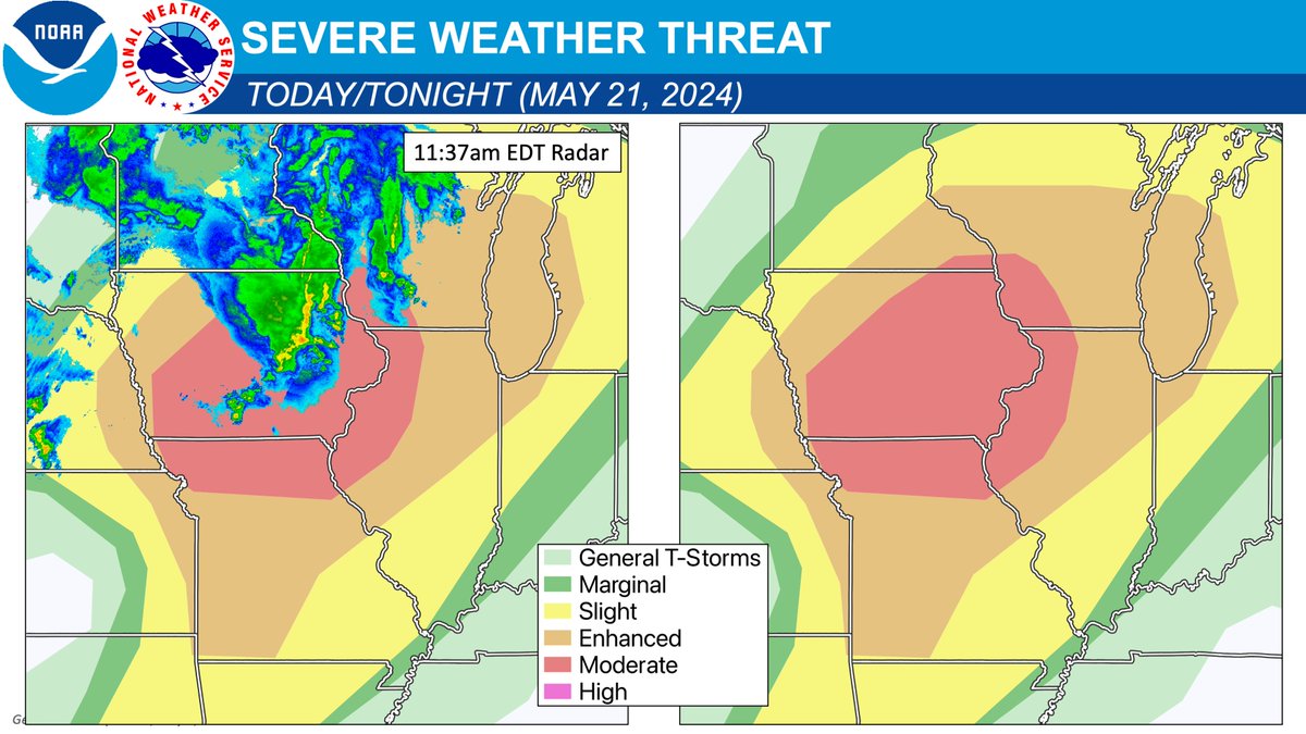
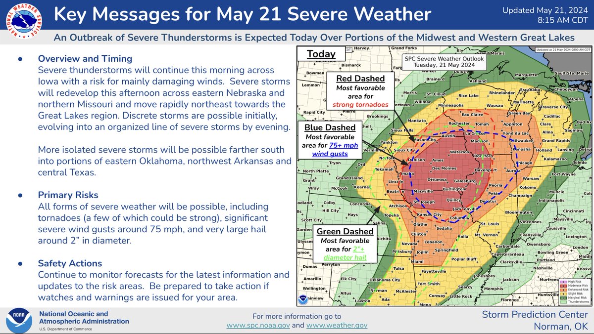
Showers and storms this morning across parts of the Midwest are bringing some severe weather and flash flooding, but this round is NOT the main severe weather event today. An outbreak of severe thunderstorms, including the potential for strong tornadoes, is expected mainly this

Showers and storms this morning across parts of the Midwest are bringing some severe weather and flash flooding, but this round is NOT the main severe weather event today. An outbreak of severe thunderstorms, including the potential for strong tornadoes, is expected mainly this
account_circle
National Weather Service(@NWS) 's Twitter Profile Photo

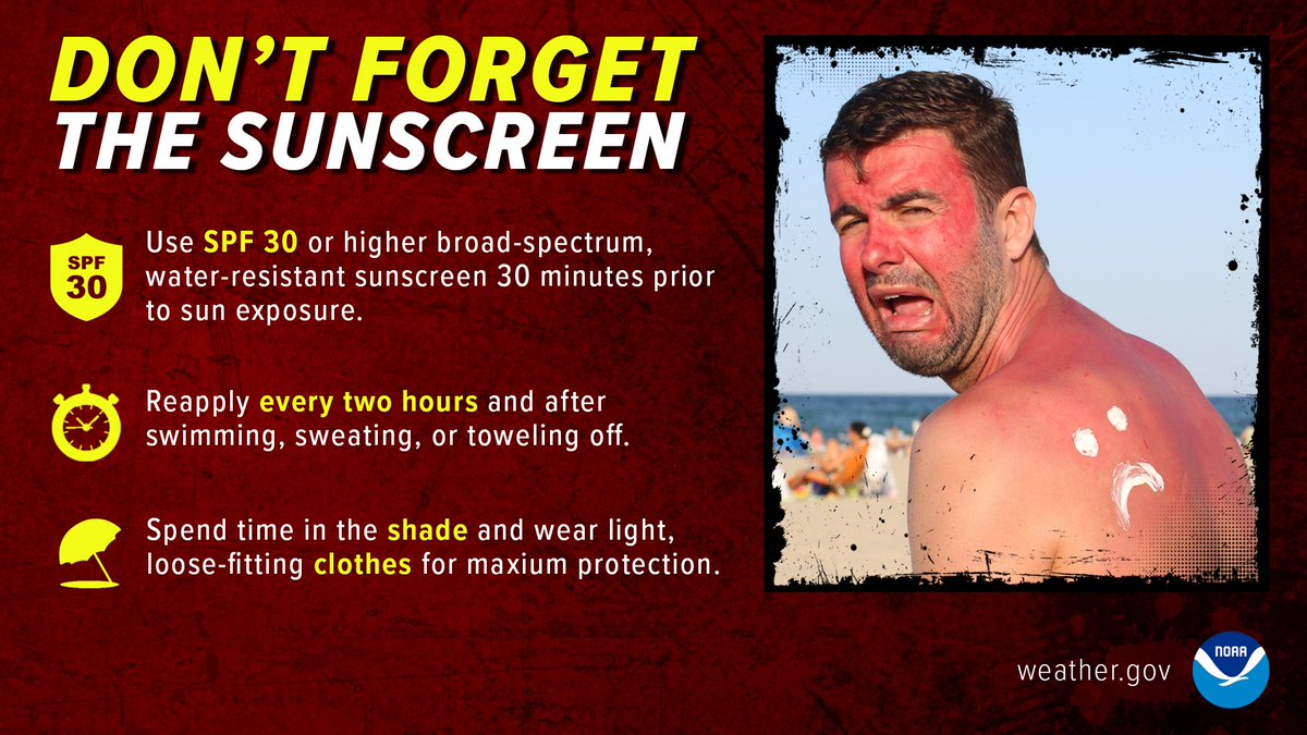
Spending time in the sun this Memorial Day Weekend?

Apply plenty of sunscreen! Also keep in mind that heat-related illness is a possibility if you don’t take precautions. Find out how to recognize & prevent heat-related illnesses at: weather.gov/safety/heat-il…

Spending time in the sun this Memorial Day Weekend? Apply plenty of sunscreen! Also keep in mind that heat-related illness is a possibility if you don’t take precautions. Find out how to recognize & prevent heat-related illnesses at: weather.gov/safety/heat-il…
account_circle
NWS Storm Prediction Center(@NWSSPC) 's Twitter Profile Photo

An outbreak of severe thunderstorms, including the potential for strong tornadoes, is expected mainly this afternoon to early evening. The greatest threat is over Iowa and parts of northwest Illinois, northern Missouri, southeast Minnesota, and southwest Wisconsin.

An outbreak of severe thunderstorms, including the potential for strong tornadoes, is expected mainly this afternoon to early evening. The greatest threat is over Iowa and parts of northwest Illinois, northern Missouri, southeast Minnesota, and southwest Wisconsin.
account_circle
National Weather Service(@NWS) 's Twitter Profile Photo

Meet Kim McMahon, who is inspired by the passion and dedication of her colleagues in the NWS. The ability to see how the work makes a difference in our communities drives the NWS to do even better every day! Learn more here: noaa.gov/careers/operat…

Meet Kim McMahon, who is inspired by the passion and dedication of her colleagues in the NWS. The ability to see how the work makes a difference in our communities drives the NWS to do even better every day! Learn more here: noaa.gov/careers/operat… #AAPI
account_circle
NWS Weather Prediction Center(@NWSWPC) 's Twitter Profile Photo

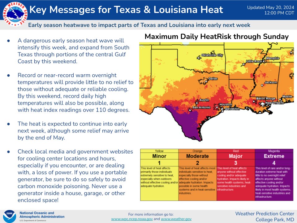
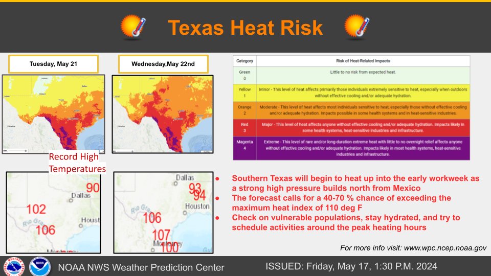
We have initiated Key Messages for an early season heatwave over parts of Texas and Louisiana that will intensify and expand over the next several days.

We have initiated Key Messages for an early season heatwave over parts of Texas and Louisiana that will intensify and expand over the next several days.
account_circle
NWS Mobile(@NWSMobile) 's Twitter Profile Photo

🦩🏖️ HOLIDAY WEEKEND - Check out your beach and forecast for vacation before you dip your toes in the sand: weather.gov/beach.

🌊 Have a blast at the beach this year and stay for maximum fun and safety! 🤙😎

🦩🏖️ HOLIDAY WEEKEND - Check out your beach and #ripcurrent forecast for vacation before you dip your toes in the sand: weather.gov/beach. 🌊 Have a blast at the beach this year and stay #BeachSmart for maximum fun and safety! 🤙😎
account_circle
National Weather Service(@NWS) 's Twitter Profile Photo

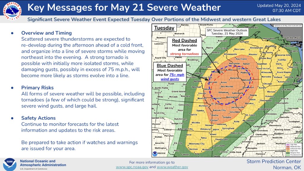
The NWS Storm Prediction Center is monitoring yet another significant severe weather outbreak possible tomorrow (Tuesday). Damaging winds, large hail, and a few, possibly strong, tornadoes are likely across portions of the Midwest.

The NWS Storm Prediction Center is monitoring yet another significant severe weather outbreak possible tomorrow (Tuesday). Damaging winds, large hail, and a few, possibly strong, tornadoes are likely across portions of the Midwest.
account_circle
NWS Storm Prediction Center(@NWSSPC) 's Twitter Profile Photo

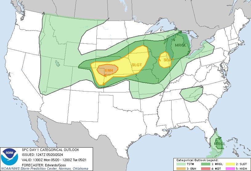
7:49am CDT Day1 Outlook Enhanced Risk: over portions of northeastern Colorado, central/southwestern Nebraska, and northwestern Kansas spc.noaa.gov/products/outlo…

7:49am CDT #SPC Day1 Outlook Enhanced Risk: over portions of northeastern Colorado, central/southwestern Nebraska, and northwestern Kansas spc.noaa.gov/products/outlo…
account_circle
National Weather Service(@NWS) 's Twitter Profile Photo

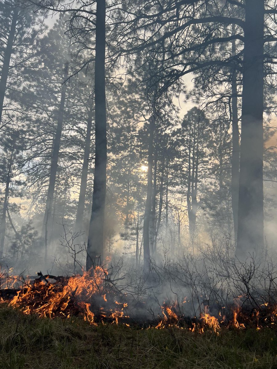
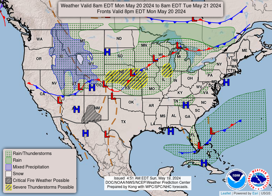
Severe thunderstorms will continue to be likely across the Central Plains into the Midwest on Monday. Thunderstorm development is also possible in portions of the Middle Mississippi Valley to Lower Michigan Monday afternoon. Gusty winds and low humidity will lead to critical fire

Severe thunderstorms will continue to be likely across the Central Plains into the Midwest on Monday. Thunderstorm development is also possible in portions of the Middle Mississippi Valley to Lower Michigan Monday afternoon. Gusty winds and low humidity will lead to critical fire
account_circle
National Weather Service(@NWS) 's Twitter Profile Photo

Severe thunderstorms will be possible over portions of the Central Plains on Sunday. An Enhanced Risk (level 3 of 5) has been issued for western and central Kansas. The main threats will be damaging wind gusts, large hail, and a few tornadoes.

account_circle
National Weather Service(@NWS) 's Twitter Profile Photo

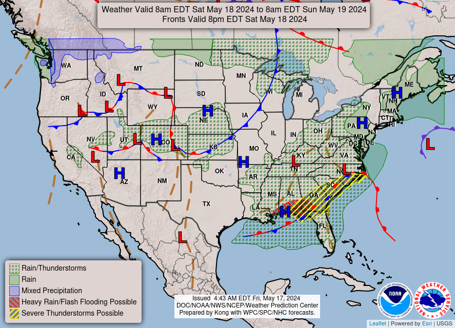
Isolated to scattered severe thunderstorms appear possible across portions of the Southeast and Carolinas on Saturday where a Slight Risk (Level 2 of 5) has been issued. A Slight Risk Excessive Rainfall Outlook (Level 2 of 4) has been issued for part of the northern Gulf Coast

Isolated to scattered severe thunderstorms appear possible across portions of the Southeast and Carolinas on Saturday where a Slight Risk (Level 2 of 5) has been issued. A Slight Risk Excessive Rainfall Outlook (Level 2 of 4) has been issued for part of the northern Gulf Coast
account_circle
National Weather Service(@NWS) 's Twitter Profile Photo

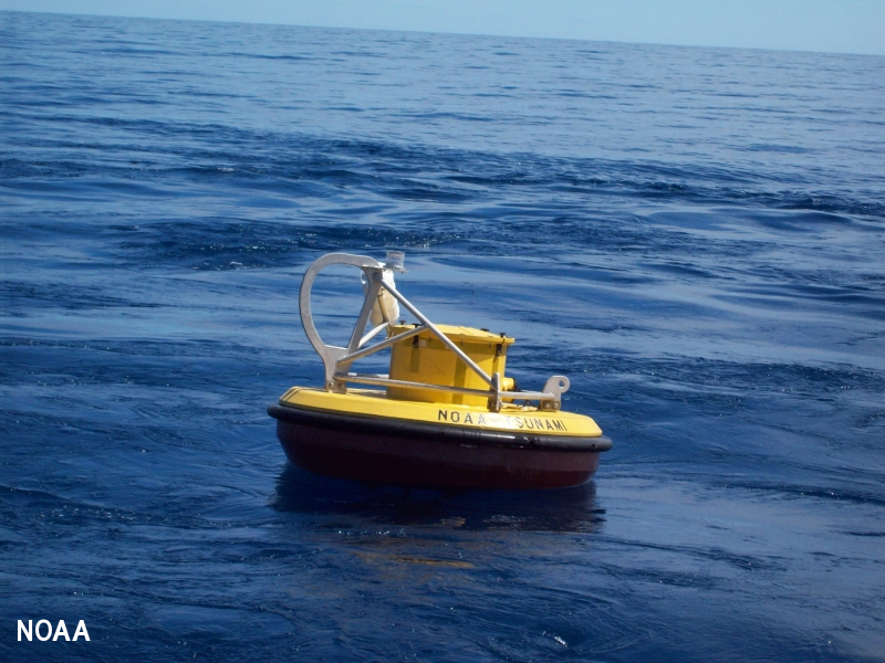
NWS to modernize the Deep-ocean Assessment and Reporting of Tsunamis (DART) buoy network to improve real-time tsunami forecasts and alerts to keep coastal communities safe.

Read more at noaa.gov/news-release/b…

NWS to modernize the Deep-ocean Assessment and Reporting of Tsunamis (DART) buoy network to improve real-time tsunami forecasts and alerts to keep coastal communities safe. Read more at noaa.gov/news-release/b…
account_circle
National Weather Service(@NWS) 's Twitter Profile Photo

Wearing a life jacket is a simple and effective measure to enhance safety and prevent drowning in aquatic environments, and today is WEAR YOUR LIFE JACKET AT WORK DAY!! 🚤🚣‍♀️⛵️🦺

account_circle
National Weather Service(@NWS) 's Twitter Profile Photo

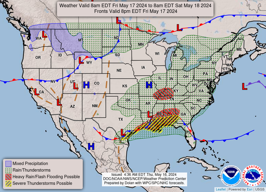
Today/Tonight: Heavy rainfall is forecast for eastern LA into central AL which could bring flash and river flooding, while scattered severe thunderstorms with a few tornadoes, very large hail, and damaging winds are possible across parts of the Gulf Coast. weather.gov

account_circle
National Weather Service(@NWS) 's Twitter Profile Photo

Heavy to excessive rainfall is forecast for eastern Louisiana into central Alabama and in the mid-Mississippi River Valley which could bring flash, urban, and riverine flooding Friday. Scattered severe thunderstorms with a few tornadoes, very large hail, and damaging winds are

Heavy to excessive rainfall is forecast for eastern Louisiana into central Alabama and in the mid-Mississippi River Valley which could bring flash, urban, and riverine flooding Friday. Scattered severe thunderstorms with a few tornadoes, very large hail, and damaging winds are
account_circle