Chris Page - Weatherman(@ChrisPage90) 's Twitter Profileg
Chris Page - Weatherman

@ChrisPage90

ITV Meteorologist & Weather Presenter for @ITVAnglia @itvweather. Previously @metoffice. Climate Ambassador. All views my own. More on Insta ☀️🌦🌈🏳️‍🌈 he/him

ID:390691770

linkhttp://chrispage.co.uk calendar_today14-10-2011 11:30:16

21,1K Tweets

14,1K Followers

1,3K Following

Follow People
Massimo(@Rainmaker1973) 's Twitter Profile Photo

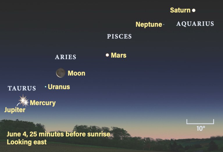
On June 4th, a rare event known as the Parade of Planets will occur.

6 planets + the crescent Moon will align in a straight line.

On June 4th, a rare event known as the Parade of Planets will occur. 6 planets + the crescent Moon will align in a straight line.
account_circle
Chris Page - Weatherman(@ChrisPage90) 's Twitter Profile Photo

⚠️ YELLOW RAIN WARNING ⚠️
Heavy rain expected Wednesday & Thursday
⌛️ Valid until 12:15am Wed to 6am Thurs
🌧 30-40mm widely
🌧50-60 mm in the wider warning zone, 100-150mm in North Wales
🌧 Localised flooding likely
🌧 A lot of spray on the roads

⚠️ YELLOW RAIN WARNING ⚠️ Heavy rain expected Wednesday & Thursday ⌛️ Valid until 12:15am Wed to 6am Thurs 🌧 30-40mm widely 🌧50-60 mm in the wider warning zone, 100-150mm in North Wales 🌧 Localised flooding likely 🌧 A lot of spray on the roads
account_circle
Chris Page - Weatherman(@ChrisPage90) 's Twitter Profile Photo

Heavy rain with embedded thunderstorms pushing in from the southeast has been impacted East Anglia for the past few hours.

Meanwhile further heavy thundery showers cracking off across Wales and the West Country.

Latest right here from Netweather.tv

Heavy rain with embedded thunderstorms pushing in from the southeast has been impacted East Anglia for the past few hours. Meanwhile further heavy thundery showers cracking off across Wales and the West Country. Latest #rainradar right here from @Netweather
account_circle
Chris Page - Weatherman(@ChrisPage90) 's Twitter Profile Photo

After a fine start, it's all change this week, but signs of something brighter by Friday.

Full ITV News Anglia forecast available here itv.com/news/anglia/we…

After a fine start, it's all change this week, but signs of something brighter by Friday. Full @itvanglia forecast available here itv.com/news/anglia/we…
account_circle
Chris Page - Weatherman(@ChrisPage90) 's Twitter Profile Photo

Time to take a break this weekend. Should be mostly dry, although a few showers possible on Saturday. Even this sea turtle is taking a well needed rest on the coral

account_circle
Philip Klotzbach(@philklotzbach) 's Twitter Profile Photo

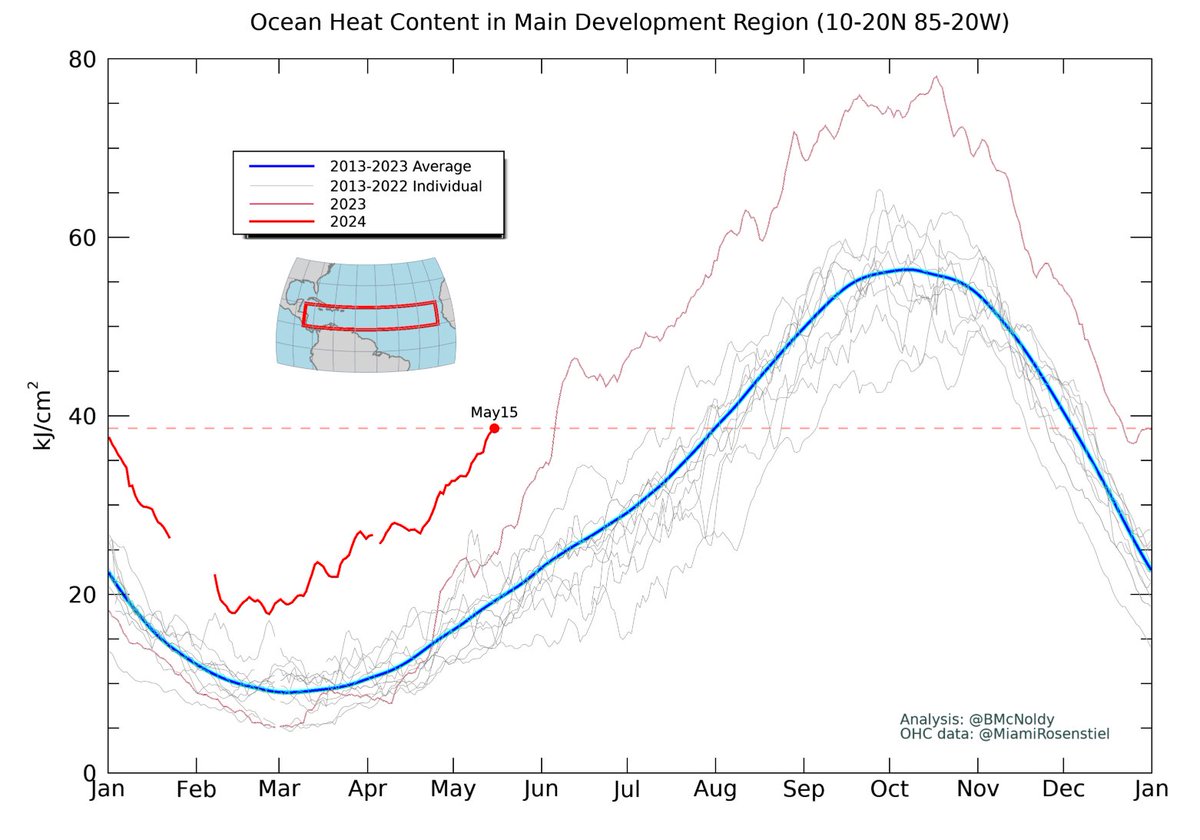
Today's ocean heat content in the Atlantic Main Development Region for is typically reached on August 1st. We're currently running about 2.5 months ahead of schedule.

Today's ocean heat content in the Atlantic Main Development Region for #hurricanes is typically reached on August 1st. We're currently running about 2.5 months ahead of schedule.
account_circle
Chris Page - Weatherman(@ChrisPage90) 's Twitter Profile Photo

I've had a number of people asking why the looks better through your camera compared to the naked eye. I explain more here:
itv.com/news/anglia/20…

account_circle
ITV News(@itvnews) 's Twitter Profile Photo

There is a 'good chance' the Aurora Borealis will be visible in the UK again tonight, according to ITV News meteorologist Chris Page - Weatherman - so when and where is best?

Full details here 👇

itv.com/news/2024-05-1…

account_circle
Chris Page - Weatherman(@ChrisPage90) 's Twitter Profile Photo

Nearly a full 24 hours of an intense causing the Aurora to be seen in both the northern and southern hemispheres!

Another good opportunity tonight. Like to see it best between 10.30pm-2pm where light pollution levels are reduced.

Get out. Look up, it’s free!

Nearly a full 24 hours of an intense #SolarStorm causing the Aurora to be seen in both the northern and southern hemispheres! Another good opportunity tonight. Like to see it best between 10.30pm-2pm where light pollution levels are reduced. Get out. Look up, it’s free!
account_circle